New Urbanism is an urban design movement that promotes environmentally friendly habits by creating walkable neighbourhoods containing a wide range of housing and job types. It arose in the United States in the early 1980s, and has gradually influenced many aspects of real estate development, urban planning, and municipal land-use strategies. New Urbanism attempts to address the ills associated with urban sprawl and post-Second World War suburban development.

Cohousing is an intentional community of private homes clustered around shared space. The term originated in Denmark in the late 1960s. Each attached or single-family home has traditional amenities, including a private kitchen. Shared spaces typically feature a common house, which may include a large kitchen and dining area, laundry, and recreational spaces. Shared outdoor space may include parking, walkways, open space, and gardens. Neighbors also share resources like tools and lawnmowers.

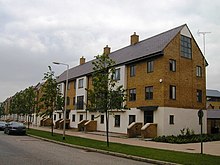
Harlow is a town and local government district located in the west of Essex, England. Founded as a new town, it is situated on the border with Hertfordshire and London, Harlow occupies a large area of land on the south bank of the upper Stort Valley, which has been made navigable through other towns and features a canal section near its watermill.

The Lansbury Estate is a large, historic council housing estate in Poplar and Bromley-by-Bow in the London Borough of Tower Hamlets. It is named after George Lansbury, a Poplar councillor and Labour Party MP.

The Housing & Development Board, is a statutory board under the Ministry of National Development responsible for the public housing in Singapore. Established in 1960 as a result of efforts in the late 1950s to set up an authority to take over the Singapore Improvement Trust's (SIT) public housing responsibilities, the HDB focused on the construction of emergency housing and the resettlement of kampong residents into public housing in the first few years of its existence.

Castle Vale is a housing estate located between Erdington, Minworth and Castle Bromwich. Currently Castle Vale makes up the Castle Vale Ward of Birmingham City Council which is part of Erdington constituency, 6 miles (9 km) northeast of Birmingham city centre in England. The area has an approximate population of 10,000 people and has a distinctly modern residential character stemming from its history as a postwar overspill estate.
Sir Frederick Ernest Gibberd CBE was an English architect, town planner and landscape designer. He is particularly known for his work in Harlow, Essex, and for the BISF house, a design for a prefabricated council house that was widely adopted in post-war Britain.
Adamstown is a planned suburban development in western County Dublin, located circa 16 km from Dublin city centre, in the jurisdiction of South Dublin County Council. The first new town in Ireland since Shannon Town in the 1960s, the development-in-progress is based on a 220 hectare Strategic Development Zone site south of the N4 road and Lucan, west of Liffey tributary the Griffeen River and north of the Grand Canal. No date has been set for the official granting of any specific long-term official status but development is underway since 2005 and as of 2015, perhaps 4,500 of a planned population of 25,000 were resident. As per the 2022 census, the population is just above 10,000. The planned scale of development is 9,000 to 10,000 dwellings, with aligned supporting infrastructure including public transport links.

Champlain Heights is a neighbourhood in the city of Vancouver, British Columbia, Canada.

The Jewellery Quarter is an area of central Birmingham, England, in the north-western area of Birmingham City Centre, with a population of 19,000 in a 1.07-square-kilometre (264-acre) area.
McKenzie Towne is a master planned residential neighbourhood in the southeast of Calgary, Alberta being developed by Carma Developers LP. The community is bordered on the west by Deerfoot Trail, on the south by Stoney Trail, on the east by 52 St. S.E., and to the north by the South Trail regional commercial centre along 130 Ave. S.E.

This article shows the notable future developments in Singapore. Most of them are currently under construction with most to be completed within the next five years.
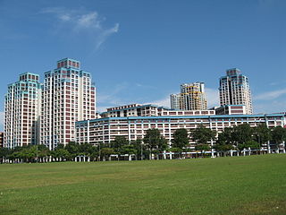
Public housing in Singapore is subsidised, built, and managed by the Government of Singapore. Starting in the 1930s, the country's first public housing was built by the Singapore Improvement Trust (SIT) in a similar fashion to contemporaneous British public housing projects, and housing for the resettlement of squatters was built from the late 1950s. In the 1960s under the SIT's successor, the Housing and Development Board (HDB), public housing consisting of small units with basic amenities was constructed as quickly and cheaply as possible at high densities and used for resettlement schemes. From the late 1960s, housing programmes focused more on quality, public housing was built in new towns, and a scheme allowing residents to lease their flats was introduced. Throughout the 1970s and 1980s, more public housing options were provided for the middle class and efforts to increase community cohesion within housing estates were made. From the 1990s, the government began portraying public housing as an asset, introducing large-scale upgrading schemes and loosening regulations on the resale of public housing while additional housing programmes for the sandwich classes and elderly residents were introduced. Rising housing prices led to public housing being seen as an investment from the 2000s, and new technologies and eco-friendly features were incorporated into housing estates.

The new towns of Singapore are planned communities located across Singapore that are designed to be self contained. Designed to house up to 300,000 residents, these new towns contain areas zoned for housing, recreation and employment, and are composed of multiple neighbourhoods, each of which is further subdivided into multiple precincts. Amenities in these new towns are provided through a multi-tiered system, and based on Housing and Development Board (HDB) guidelines. As of 2022, the country has 24 new towns.

Church Langley is part of Harlow, Essex, England.

The Regent Park Revitalization Plan is an initiative begun in 2005 by the City of Toronto with fellow development, government, and community partners, with a focus on rebuilding the Toronto neighbourhood of Regent Park for 12,500 residents over a 15- to 20-year period. The project entails transforming what was once solely a social housing development into a self-sufficient, mixed-income, multi-use community.

Drumsagard Village is a new construction village in Cambuslang, South Lanarkshire. It is built around the site of Drumsagard Castle and immediately south of the site of Hallside Steelworks, also known as the Cambuslang Iron and Steel Works. One of the first facilities of their kind and eventually extending over an area of around 33 acres, the steelworks were established in 1873 and closed in 1979.

Essex Crossing is an under-construction mixed-use development in New York City's Lower East Side, at the intersection of Delancey Street and Essex Street just north of Seward Park. Essex Crossing will comprise nearly 2,000,000 sq ft (200,000 m2) of space on 6 acres and will cost an estimated US$1.1 billion. Part of the existing Seward Park Urban Renewal Area (SPURA), the development will sit on a total of nine city blocks, most of them occupied by parking lots that replaced tenements razed in 1967.
Complete communities is an urban and rural planning concept that aims to meet the basic needs of all residents in a community, regardless of income, culture, or political ideologies through integrated land use planning, transportation planning, and community design. While the concept is used by many communities as part of their community plan, each plan interprets what complete community means in their own way. The idea of the complete community has roots in early planning theory, beginning with The Garden City Movement, and is a component of contemporary planning methods including Smart Growth.
Jocelyn Frere Adburgham (formerly Abram) (24 May 1900 – 23 January 1979) was a British architect and town planner, and the first woman admitted to professional membership of what is now the Royal Town Planning Institute.