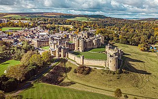
Alnwick Castle is a castle and country house in Alnwick in the English county of Northumberland. It is the seat of the 12th Duke of Northumberland, built following the Norman conquest and renovated and remodelled a number of times. It is a Grade I listed building now the home of Ralph Percy, 12th Duke of Northumberland and his family. In 2016, the castle received over 600,000 visitors per year when combined with adjacent attraction the Alnwick Garden.
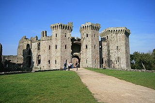
Raglan Castle is a late medieval castle located just north of the village of Raglan in the county of Monmouthshire in south east Wales. The modern castle dates from between the 15th and early 17th centuries, when the successive ruling families of the Herberts and the Somersets created a luxurious, fortified castle, complete with a large hexagonal keep, known as the Great Tower or the Yellow Tower of Gwent. Surrounded by parkland, water gardens and terraces, the castle was considered by contemporaries to be the equal of any other in England or Wales.

A keep is a type of fortified tower built within castles during the Middle Ages by European nobility. Scholars have debated the scope of the word keep, but usually consider it to refer to large towers in castles that were fortified residences, used as a refuge of last resort should the rest of the castle fall to an adversary. The first keeps were made of timber and formed a key part of the motte-and-bailey castles that emerged in Normandy and Anjou during the 10th century; the design spread to England, Portugal, south Italy and Sicily. As a result of the Norman Conquest of England in 1066, use spread into Wales during the second half of the 11th century and into Ireland in the 1170s. The Anglo-Normans and French rulers began to build stone keeps during the 10th and 11th centuries, including Norman keeps, with a square or rectangular design, and circular shell keeps. Stone keeps carried considerable political as well as military importance and could take a decade or more to build.

Kirby Muxloe Castle, also known historically as Kirby Castle, is a ruined, fortified manor house in Kirby Muxloe, Leicestershire, England. William, Lord Hastings, began work on the castle in 1480, founding it on the site of a pre-existing manor house. William was a favourite of King Edward IV and had prospered considerably during the Wars of the Roses. Work continued quickly until 1483, when William was executed during Richard, Duke of Gloucester's, seizure of the throne. His widow briefly continued the project after his death but efforts then ceased, with the castle remaining largely incomplete. Parts of the castle were inhabited for a period, before falling into ruin during the course of the 17th century. In 1912, the Commissioners of Work took over management of the site, repairing the brickwork and carrying out an archaeological survey. In the 21st century, the castle is controlled by English Heritage and open to visitors.

Newton St Loe is a small Somerset village and civil parish located close to the villages of Corston and Stanton Prior, between Bath and Bristol in England. The majority of the village is owned by the Duchy of Cornwall. The parish has a population of 681.

Dunster Castle is a former motte and bailey castle, now a country house, in the village of Dunster, Somerset, England. The castle lies on the top of a steep hill called the Tor, and has been fortified since the late Anglo-Saxon period. After the Norman Conquest of England in the 11th century, William de Mohun constructed a timber castle on the site as part of the pacification of Somerset. A stone shell keep was built on the motte by the start of the 12th century, and the castle survived a siege during the early years of the Anarchy. At the end of the 14th century the de Mohuns sold the castle to the Luttrell family, who continued to occupy the property until the late 20th century.

Nunney Castle is a medieval castle at Nunney in the English county of Somerset. Built in the late 14th century by Sir John Delamare on the profits of his involvement in the Hundred Years' War, the moated castle's architectural style, possibly influenced by the design of French castles, has provoked considerable academic debate. Remodelled during the late 16th century, Nunney Castle was damaged during the English Civil War and is now ruined.
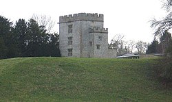
Sutton Court is an English house remodelled by Thomas Henry Wyatt in the 1850s from a manor house built in the 15th and 16th centuries around a 14th-century fortified pele tower and surrounding buildings. The house has been designated as Grade II* listed building.

Bowes Castle is a medieval castle in the village of Bowes in County Durham, England. Built within the perimeter of the former Roman fort of Lavatrae, on the Roman road that is now the A66, the early timber castle on the site was replaced by a more substantial stone structure between 1170 and 1174 on the orders of Henry II. A planned village was built alongside the castle. Bowes Castle withstood Scottish attack during the Great Revolt of 1173–74 but was successfully looted by rebels in 1322. The castle went into decline and was largely dismantled after the English Civil War. The ruins are now owned by English Heritage and managed as a tourist attraction. There is free admission during daylight hours.

Englishcombe is a village and civil parish in Bath and North East Somerset just south-west of Bath, England. The parish, which also includes the hamlets of Inglesbatch and Nailwell, had a population of 318 at the 2011 census.

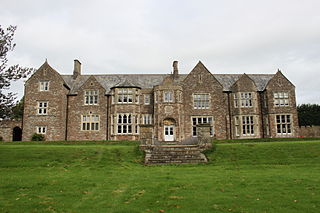
Newton Park is an 18th-century Grade I listed country house in the parish of Newton St Loe, Somerset, England, situated 4 miles (6.4 km) west of Bath.
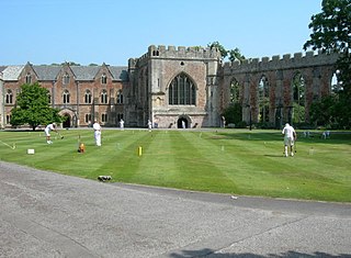
The Bishop's Palace is the residence of the bishop of Bath and Wells in Wells, Somerset, England. The palace is adjacent to Wells Cathedral and has been the residence of the bishops since the early thirteenth century. It has been designated a grade I listed building.

The Grade I listed buildings in Somerset, England, demonstrate the history and diversity of its architecture. The ceremonial county of Somerset consists of a non-metropolitan county, administered by Somerset County Council, which is divided into five districts, and two unitary authorities. The districts of Somerset are West Somerset, South Somerset, Taunton Deane, Mendip and Sedgemoor. The two administratively independent unitary authorities, which were established on 1 April 1996 following the breakup of the county of Avon, are North Somerset and Bath and North East Somerset. These unitary authorities include areas that were once part of Somerset before the creation of Avon in 1974.
Taunton Deane is a local government district with borough status in the English county of Somerset. In the United Kingdom, the term listed building refers to a building or other structure officially designated as being of special architectural, historical or cultural significance; Grade I structures are those considered to be "buildings of exceptional interest". Listing was begun by a provision in the Town and Country Planning Act 1947. Once listed, severe restrictions are imposed on the modifications allowed to a building's structure or its fittings. In England, the authority for listing under the Planning Act 1990 rests with Historic England, a non-departmental public body sponsored by the Department for Digital, Culture, Media and Sport; local authorities have a responsibility to regulate and enforce the planning regulations.

Stogursey Castle is a medieval castle in Somerset, England. Most of the site is in ruins, but there is a thatched gatehouse used for holiday rental by the Landmark Trust.
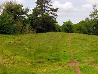
Richmont Castle was an 11th-century motte-and-bailey castle near the village of East Harptree, Somerset, England. Now totally ruined, it once included parkland, an artificial lake and served as the local minery court.

Whorlton Castle is a ruined medieval castle situated near the abandoned village of Whorlton in North Yorkshire, England. It was established in the early 12th century as a Norman motte-and-bailey associated with the nearby settlement. The castle is an unusual example of a motte-and-bailey that remained in use throughout the Middle Ages and into the early modern period.
The Anglican Church of the Holy Trinity in Newton St Loe within the English county of Somerset is a Grade II* listed building.