Ngataki

Last updated

Ngataki
Ngataki
Coordinates: 34°44′30″S173°2′48″E / 34.74167°S 173.04667°E / -34.74167; 173.04667 Coordinates: 34°44′30″S173°2′48″E / 34.74167°S 173.04667°E / -34.74167; 173.04667
CountryNew Zealand
Region Northland Region
District Far North District
WardTe Hiku
Electorates
Government
  Territorial Authority Far North District Council
  Regional council Northland Regional Council
Area
[1]
  Total51.33 km2 (19.82 sq mi)
Population
 (2018 census) [2]
  Total105
  Density2.0/km2 (5.3/sq mi)

Ngataki is a community on the Aupouri Peninsula in Northland, New Zealand. State Highway 1 runs through the area. To the east is Rarawa Beach, a mile-long strip of clean silver sand, gently shelving and backed by sand dunes. [3] To the north-east is the Great Exhibition Bay and Rarawa Bay and to the south-west is the long Ninety Mile Beach coastline. [4]

Contents

Marae

The local Waiora Marae and meeting house are a traditional meeting place for Ngāti Kurī. [5] [6]

Demographics

Ngataki is in an SA1 statistical area which covers 51.33 km2 (19.82 sq mi) [1] and includes Rarawa Beach and the peninsula on the east side of Houhora Harbour. The SA1 area is part of the larger North Cape statistical area. [7]

Historical population
YearPop.±% p.a.
200675    
201393+3.12%
2018105+2.46%
Source: [2]

The SA1 statistical area had a population of 105 at the 2018 New Zealand census, an increase of 12 people (12.9%) since the 2013 census, and an increase of 30 people (40.0%) since the 2006 census. There were 51 households, comprising 51 males and 57 females, giving a sex ratio of 0.89 males per female. The median age was 44.8 years (compared with 37.4 years nationally), with 24 people (22.9%) aged under 15 years, 15 (14.3%) aged 15 to 29, 54 (51.4%) aged 30 to 64, and 15 (14.3%) aged 65 or older.

Ethnicities were 77.1% European/Pākehā, 40.0% Māori, 2.9% Pacific peoples, 2.9% Asian, and 2.9% other ethnicities. People may identify with more than one ethnicity.

Of those people who chose to answer the census's question about religious affiliation, 51.4% had no religion, 34.3% were Christian and 2.9% had other religions.

Of those at least 15 years old, 21 (25.9%) people had a bachelor or higher degree, and 12 (14.8%) people had no formal qualifications. The median income was $32,500, compared with $31,800 nationally. 15 people (18.5%) earned over $70,000 compared to 17.2% nationally. The employment status of those at least 15 was that 42 (51.9%) people were employed full-time, 15 (18.5%) were part-time, and 6 (7.4%) were unemployed. [2]

Education

Ngataki School is a coeducational full primary (years 1–8) school [8] with a roll of 31 students as of February 2023. [9] The school was founded about 1911. [10]

Attractions

Rarawa Beach is located near Ngataki, on the eastern Pacific coast. [11]

Rarawa Beach in the morning in autumn. Rarawa Beach morning.jpg
Rarawa Beach in the morning in autumn.

In December 2008, school students planted one hundred and twenty rare coastal Holloway's Crystalwort – Atriplex hollowayi plants, small native herbs that grow near high tide level on sandy beaches. In 2009, Ngataki School and the New Zealand Department of Conservation worked together to help restore the beach, a home to dotterels and oystercatchers, because the ecosystem was under threat as a result of natural and man-made causes. [12]

In September 2010, fourteen rescued pilot whales swam strongly out to sea at Rarawa Beach after being rescued from a mass whale stranding at Spirits Bay. [13] The transportation of the whales to Rarawa Beach was considered to be the largest whale transport ever attempted. [14]

In 2011, day four of the National Scholastic Surfing Championship was held at Rarawa Beach. [15]

Related Research Articles

<span class="mw-page-title-main">Northland Region</span> Region of New Zealand

The Northland Region is the northernmost of New Zealand's 16 local government regions. New Zealanders sometimes refer to it as the Winterless North because of its mild climate all throughout the year. The main population centre is the city of Whangārei, and the largest town is Kerikeri. At the 2018 New Zealand census, Northland recorded a population growth spurt of 18.1% since the previous 2013 census, placing it as the fastest growing region in New Zealand, ahead of other strong growth regions such as the Bay of Plenty Region and Waikato.

<span class="mw-page-title-main">Waimārama</span> Settlement in Hawkes Bay Region, New Zealand

Waimārama is a seaside village in Hastings District, Hawke's Bay, New Zealand.

<span class="mw-page-title-main">Waimate North</span> Place in Northland Region, New Zealand

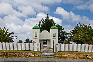
Waimate North is a small settlement in Northland, New Zealand. It is situated between Kerikeri and Lake Ōmāpere, west of the Bay of Islands.

<span class="mw-page-title-main">Ahipara</span> Place in Northland Region, New Zealand

Ahipara is a town and locality in Northland, New Zealand at the southern end of Ninety Mile Beach, with the Tauroa Peninsula to the west and Herekino Forest to the east. Ahipara Bay is to the north west. Kaitaia is 14 km to the north east, and Pukepoto is between the two.

<span class="mw-page-title-main">Herekino</span> Place in Northland Region, New Zealand

Herekino is a locality in Northland, New Zealand. It lies 26 km south west of Kaitaia. The Herekino Harbour, also called the Herekino River, is an estuary and inlet from the Tasman Sea to the west. The Herekino Forest, which contains a stand of large kauri, is to the north, and the Tauroa Peninsula lies to the north west.

Tautoro is a locality about 8 km south-southeast of Kaikohe in Northland, New Zealand. Further to the south is the Awarua rural community.

<span class="mw-page-title-main">Te Kao</span> Place in Northland Region, New Zealand

Te Kao is a village on the Aupouri Peninsula of Northland, New Zealand. Te Aupōuri are mana whenua over Te Kao and the surrounding district, and it is the principal settlement of the iwi (tribe). Te Aupōuri's Post-Settlement Governance Entity, Te Runanga Nui o Te Aupōuri, has an office at Te Kao, along with the iwi's marae and urupa. State Highway 1 passes through the district. Cape Reinga is 46 km to the north, and Houhora is 24 km to the south. The Aupouri Forest and Ninety Mile Beach are to the west.

Pukepoto is a town in Northland, New Zealand. It lies south west of Kaitaia and north east of Ahipara. The Herekino Forest lies to the south east.

<span class="mw-page-title-main">Whangape Harbour</span> Body of water

Whangape Harbour is a harbour on the west coast of Northland, New Zealand. There is a settlement called Whangape on the northern side of the harbour. Another, called Pawarenga, is located on the southern side. Kaitaia is 42 km north east.

Waikare is a locality in Northland, New Zealand. The Waikare River flows from the Russell Forest past Waikare and into the Waikare Inlet, which leads into the Bay of Islands.

Panguru is a community in the northern Hokianga harbour, in Northland, New Zealand. The Whakarapa Stream flows from the Panguru Range in the Warawara Forest to the west, through Panguru and into the Hokianga.

Waiharara is a community at the base of the Aupouri Peninsula in Northland, New Zealand. State Highway 1 runs through the community. To the west is Aupouri Forest, and beyond that Ninety Mile Beach. To the east is Rangaunu Harbour. Houhora is 22 km north west, and Awanui is 16 km south east. Lake Waiparera, 35 metres above sea level, is immediately to the north west.

Waimā is a community in the south Hokianga area of Northland, New Zealand. State Highway 12 runs through the area. The Waima River flows through the Waima Valley into the Hokianga Harbour. Rawene is to the north west, and Kaikohe is to the north east.

Motatau or Mōtatau is a locality in the Northland Region of the North Island of New Zealand. Maromaku is to the east. The Taikirau Stream flows from east through Motatau and then runs northwest to join the Waiharakeke Stream. The North Auckland Line runs through Motatau.

Maungakaramea is a locality in Northland, New Zealand. Whangārei is to the northeast.

Pipiwai is a locality in the Te Horo valley in Northland, New Zealand. Whangārei is about 35 km to the southeast. Titoki is about 16 km to the south.

<span class="mw-page-title-main">Pataua</span> Place in Northland Region, New Zealand

Pataua is a settlement in Northland Region, New Zealand. It lies at the mouth of the Pataua River on the Pacific Ocean. Pataua North and Pataua South are separated by a footbridge over the estuary.

<span class="mw-page-title-main">Taupō Bay</span> Place in Northland Region, New Zealand

Taupō Bay is a bay, village and rural community in the Far North District and Northland Region of New Zealand's North Island. There are about 40 permanent residents, and 180 properties. The white sand beach is 1.5 km wide.

<span class="mw-page-title-main">Takahue</span> Rural community in New Zealand

Takahue is a rural community in the Far North District and Northland Region of New Zealand's North Island, south of Kaitaia.

<span class="mw-page-title-main">Waiotahe</span> Rural settlement in the Bay of Plenty Region, New Zealand

Waiotahe is a beach, settlement and rural community in the Ōpōtiki District and Bay of Plenty Region of New Zealand's North Island, near the mouth and lowermost stretch of the Waiotahe River.

References

  1. 1 2 "ArcGIS Web Application". statsnz.maps.arcgis.com. Retrieved 18 March 2022.
  2. 1 2 3 "Statistical area 1 dataset for 2018 Census". Statistics New Zealand. March 2020. 7000006.
  3. Parkes, W. F. (c. 1965). The Visitors' Guide to the Far North - Mangonui County (3rd ed.). p. 36.
  4. "Ngataki Travel Guide". Jasons Travel Media.
  5. "Te Kāhui Māngai directory". tkm.govt.nz. Te Puni Kōkiri.
  6. "Māori Maps". maorimaps.com. Te Potiki National Trust.
  7. 2018 Census place summary: North Cape
  8. Education Counts: Ngataki School
  9. "New Zealand Schools Directory". New Zealand Ministry of Education. Retrieved 12 December 2022.
  10. ""Ngataki School party called off". Northern Advocate. 30 September 2011.
  11. Great NZ Beaches: Daniel Kereopa – Travel – NZ Herald News Retrieved December 2011
  12. ‘Sugar-coated’ help to restore Rarawa Beach | Stuff.co.nz Retrieved December 2011
  13. Northland buzzing after whales’ great escape – Story – National – 3 News Archived 10 January 2011 at the Wayback Machine Retrieved December 2011
  14. A dozen whales refloated, three die – National – NZ Herald News Retrieved December 2011
  15. Northland Back At Top Of Congested Leader Board – News – Surf.co.nz Archived 2011-11-26 at the Wayback Machine Retrieved December 2011