
The Niagara River flows north from Lake Erie to Lake Ontario, forming part of the border between Ontario, Canada, to the west, and New York, United States, to the east. The origin of the river's name is debated. Iroquoian scholar Bruce Trigger suggests it is derived from a branch of the local Neutral Confederacy, referred to as the Niagagarega people on several late-17th-century French maps. George R. Stewart posits that it comes from an Iroquois town named Ongniaahra, meaning "point of land cut in two."
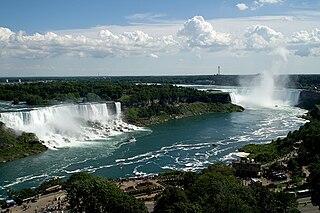
Niagara Falls is a group of three waterfalls at the southern end of Niagara Gorge, spanning the border between the province of Ontario in Canada and the state of New York in the United States. The largest of the three is Horseshoe Falls, which straddles the international border of the two countries. It is also known as the Canadian Falls. The smaller American Falls and Bridal Veil Falls lie within the United States. Bridal Veil Falls is separated from Horseshoe Falls by Goat Island and from American Falls by Luna Island, with both islands situated in New York.

Lewiston is a village in Niagara County, New York, United States. The population was 2,701 at the 2010 census. The village is named after Morgan Lewis, an early 19th-century governor of New York. It is part of the Buffalo–Niagara Falls Metropolitan Statistical Area.

Queenston is a compact rural community and unincorporated place 5 kilometres (3.1 mi) north of Niagara Falls in the Town of Niagara-on-the-Lake, Ontario, Canada. It is bordered by Highway 405 to the south and the Niagara River to the east; its location at the eponymous Queenston Heights on the Niagara Escarpment led to the establishment of the Queenston Quarry in the area. Across the river and the Canada–US border is the village of Lewiston, New York. The Lewiston-Queenston Bridge links the two communities. This village is at the point where the Niagara River began eroding the Niagara Escarpment. During the ensuing 12,000 years the Falls cut an 11 kilometres (6.8 mi) long gorge in the Escarpment southward to its present-day position.
Chippawa is a community located within the city of Niagara Falls, Ontario.
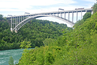
The Lewiston–Queenston Bridge, also known as the Queenston–Lewiston Bridge, is an arch bridge that crosses the Niagara River gorge just south of the Niagara Escarpment. The bridge was officially opened on November 1, 1962. It is an international bridge between the United States and Canada. It connects Interstate 190 in the town of Lewiston, New York to Highway 405 in the community of Queenston, Ontario. The Lewiston–Queenston Bridge is architecturally similar to the Rainbow Bridge at nearby Niagara Falls.
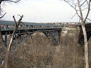
The Whirlpool Rapids Bridge, commonly known as the Whirlpool Bridge or the Lower Steel Arch Bridge, is a spandrel braced, riveted, two-hinged arch bridge that crosses the Canada–United States border, connecting the commercial downtown districts of Niagara Falls, Ontario, and Niagara Falls, New York. This bridge is located approximately 1.5 kilometres (0.9 mi) north of the Rainbow Bridge and about 2 kilometres (1.2 mi) from the Falls. It was acquired by the Niagara Falls Bridge Commission in January 1959. Immediately upstream is the similar arch-style Michigan Central Railway Bridge, which has been out of service since 2001.

The Niagara Cantilever Bridge or Michigan Central Railway Cantilever Bridge was a cantilever bridge across the Niagara Gorge. An international railway-only bridge between Canada and the United States, it connected Niagara Falls, New York, and Niagara Falls, Ontario, located just south of the Whirlpool Bridge, and opened to traffic in 1883, it was replaced by the Michigan Central Railway Steel Arch Bridge in 1925.

Niagara Gorge is an 11 km (6.8 mi) long canyon carved by the Niagara River along the Canada–United States border, between the U.S. state of New York and the Canadian province of Ontario. It begins at the base of Niagara Falls and ends downriver at the edge of the geological formation known as the Niagara Escarpment near Queenston, Ontario, where the falls originated about 12,500 years ago. The position of the falls has receded upstream toward Lake Erie because of the falling waters' slow erosion of the riverbed's hard Lockport dolomite, combined with rapid erosion of the relatively soft layers beneath it. This erosion has created the gorge.
The Buffalo and Niagara Falls Railroad was a part of the New York Central Railroad system, connecting Buffalo, New York to Niagara Falls. It is still used by CSX for freight and Amtrak for passenger service.
The Niagara Falls Bridge Commission is an international public agency which administers three international bridges across the Niagara River connecting the province of Ontario, Canada, and the state of New York, United States: the Lewiston–Queenston Bridge, Whirlpool Rapids Bridge and Rainbow Bridge. The NFBC is incorporated as a class D New York State public benefit corporation and is licensed to operate in Ontario under the Extra-Provincial Corporations Act. The commission is based in Lewiston, New York, and maintains a post office box address in Niagara Falls, Ontario. It is mostly self-supporting from tolls, leases, and commercial concessions.

The Great Gorge Route or Niagara Belt Line was an interurban trolley belt line encompassing the Niagara Gorge, operated by the International Railway and Niagara Gorge Railroad. Many dignitaries rode this line and they used to use a flat car with search light to illuminate the Niagara Whirlpool at night.

The Michigan Central Railway Bridge is an out-of-service steel Deck arch bridge spanning the Niagara Gorge between Niagara Falls, Ontario and Niagara Falls, New York. The bridge is owned by Canadian Pacific Kansas City, which purchased the single track structure in 1990. The Canadian corridor and bridge are owned by the City of Niagara Falls, Ontario. The bridge is located just upstream from the older arch-style Whirlpool Rapids Bridge used by Maple Leaf Amtrak passenger trains.
The Niagara Parkway, formerly known as Niagara Boulevard and historically as the Niagara Road, is a scenic road in the province of Ontario that travels on the Canadian side of the Niagara River from the town of Fort Erie to Niagara-on-the-Lake. The portion north of Table Rock in the city of Niagara Falls is designated as an Ontario Scenic Highway. Niagara Boulevard originally referred only to the section from Fort Erie to Chippawa.

The International Railway Company (IRC) was a transportation company formed in a 1902 merger between several Buffalo-area interurban and street railways. The city railways that merged were the West Side Street Railway, the Crosstown Street Railway and the Buffalo Traction Company. The suburban railroads that merged included the Buffalo & Niagara Electric Street Railway, and its subsidiary the Buffalo, Lockport & Olcott Beach Railway; the Buffalo, Depew & Lancaster Railway; and the Niagara Falls Park & River Railway. Later the IRC acquired the Niagara Gorge Railroad (NGRR) as a subsidiary, which was sold in 1924 to the Niagara Falls Power Company. The NGRR also leased the Lewiston & Youngstown Frontier Railroad.

The Niagara Falls Station and Customhouse Interpretive Center is an intermodal transit complex in Niagara Falls, New York. It serves Amtrak trains and Niagara Frontier Transportation Authority buses, houses U.S. Customs and Border Protection offices servicing the Canada–United States border, and houses the Niagara Falls Underground Railroad Heritage Center.

Sault Ste. Marie Bridge Company is a subsidiary of the Wisconsin Central Ltd. It operates a railroad bridge over the St. Marys River between Sault Ste. Marie, Michigan and Sault Ste. Marie, Ontario.

The Niagara Rainbow, known as the Empire State Express before 1976, was an American passenger train service operated by Amtrak between New York City and Detroit via Buffalo and Southwestern Ontario in Canada. The service ran between October 31, 1974, and January 31, 1979.


