
Musa I was the ninth mansa of the Mali Empire, which reached its territorial peak during his reign. Musa is known for his wealth and generosity. He has been subject to popular claims that he is the wealthiest person in history, but his actual wealth is not known with any certainty. His riches came from the mining of significant gold and salt deposits in the Mali Empire, along with the slave and ivory trade.

The Mali Empire was an empire in West Africa from c. 1226 to 1670. The empire was founded by Sundiata Keita and became renowned for the wealth of its rulers, especially Mansa Musa. The Manding languages were spoken in the empire. At its peak, Mali was the largest empire in West Africa, widely influencing the culture of the region through the spread of its language, laws and customs. Much of the recorded information about the Mali Empire comes from 14th-century Tunisian historian Ibn Khaldun, 14th-century Moroccan traveller Ibn Battuta and 16th-century Andalusian traveller Leo Africanus. The other major source of information is Mandinka oral tradition, as recorded by storytellers known as griots.

The Mandinka or Malinke are a West African ethnic group primarily found in southern Mali, the Gambia and eastern Guinea. Numbering about 11 million, they are the largest subgroup of the Mandé peoples and one of the largest ethnic-linguistic groups in Africa. They speak the Manding languages in the Mande language family and a lingua franca in much of West Africa. Over 99% of Mandinka adhere to Islam. They are predominantly subsistence farmers and live in rural villages. Their largest urban center is Bamako, the capital of Mali.

The Songhai Empire was a state that dominated the western Sahel/Sudan in the 15th and 16th century. At its peak, it was one of the largest states in African history. The state is known by its historiographical name, derived from its leading ethnic group and ruling elite, the Songhai. Sonni Ali established Gao as the capital of the empire although a Songhai state had existed in and around Gao since the 11th century. Other important cities in the empire were Timbuktu and Djenné, conquered in 1468 and 1475 respectively, where urban-centered trade flourished and to the south is the north Akan state of Bonoman. Initially, the empire was ruled by the Sonni dynasty, but it was later replaced by the Askia dynasty (1493–1901).
Sundiata Keita was a prince and founder of the Mali Empire. He is also the great-uncle of the Malian ruler Mansa Musa, known for being the wealthiest person of all time.
In 1324, while staying in Cairo during his hajj, Mansa Musa, the ruler of the Mali Empire, told an Egyptian official whom he had befriended that he had come to rule when his predecessor led a fleet in an attempt to cross the Atlantic Ocean and never returned. This account, recorded by the Arab historian al-Umari, has attracted considerable interest and speculation as a possible instance of pre-Columbian trans-oceanic contact. The voyage is popularly attributed to a Mansa Abu Bakr II, but no such mansa ever reigned. Rather, the voyage is inferred to have been undertaken by Mansa Muhammad ibn Qu.
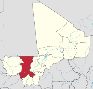
Koulikoro Region is a region in western Mali. It is the second administrative area of Mali and covers an area of 90,120 km2. Its capital is the city of Koulikoro.
The Mandé peoples are ethnic groups who are speakers of Mande languages. Various Mandé speaking ethnic groups are found particularly toward the west of West Africa. The Mandé Speaking languages are divided into two primary groups: East Mandé and West Mandé.

Siguiri is a city in northeastern Guinea on the River Niger. It is a sub-prefecture and capital of Siguiri Prefecture in the Kankan Region. Its population was estimated at 28,319 in 2008.
Wassoulou is a cultural area and historical region in the Wassoulou River Valley of West Africa. It is home to about 160,000 people, and is also the native land of the Wassoulou genre of music.
The Keita dynasty ruled pre-imperial and imperial Mali from the 11th century into the early 17th century. It was a Muslim dynasty, and its rulers claimed descent from Bilal Keita, despite Bilal having been of Abyssinian origin.

Kouroussa or Kurussa is a town located in northeastern Guinea, and is the capital of Kouroussa Prefecture. As of 2014 it had a population of 39,611 people. A trade center and river port from at least the time of the Mali Empire, Kouroussa has long relied upon its position near the upstream limit of navigation of the Niger River to make it an important crossroads for people and goods moving between the Guinea coast and the states of the western Soudan and Niger River valley. The town and surrounding area is a center of Malinke culture, and is known for its Djembe drumming tradition.
The Wangara are a subgroup of the Soninke who later became assimilated merchant classes that specialized in both Trans Saharan and Secret Trade of Gold Dust. Their diaspora operated all throughout West Africa Sahel-Sudan. Fostering regionally organized trade networks and Architecture projects. But based in the many Sahelian and Niger-Volta-Sene-Gambia river city-states. Particularly Dia, Timbuktu, Agadez, Kano, Gao, Koumbi Saleh, Guidimaka, Salaga, Kong, Bussa, Bissa, Kankan, Jallon, Djenné as well as Bambouk, Bure, Lobi, and Bono State goldfields and Borgu. They also were practicing Muslims with a clerical social class (Karamogo), Timbuktu Alumni political advisors, Sufi Mystic healers and individual leaders (Marabout). Living by a philosophy of merchantile pacifism called the Suwarian Tradition. Teaching peaceful coexistence with non-Muslims, reserving Jihad for self-defence only and even serving as Soothsayers or a "priesthood" of literate messengers for non-Muslim Chiefdoms/Kingdoms. This gave them a degree of control and immense wealth in lands where they were the minority. Creating contacts with almost all West African religious denominations. A group of Mande traders, loosely associated with the Kingdoms of the Sahel region and other West African Empires. Such as Ghana, Mali, Songhai, Yorubaland, Bono State, Kong, Borgu, Dendi, Macina, Hausa Kingdoms & the Pashalik of Timbuktu. Wangara also describes any land south of Timbuktu and Agadez. The Bilad-Al-Sudan or Bilad-Al-Tibr, "Land of Black" or "Gold."
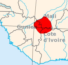
The Kaabu Empire (1537–1867), also written Gabu, Ngabou, and N'Gabu, was an empire in the Senegambia region centered within modern northeastern Guinea-Bissau, larger parts of today's Gambia; extending into Koussanar, Koumpentoum, regions of Southeastern Senegal, and Casamance in Senegal. The Kaabu Empire consisted of several languages, namely: Balanta, Jola-Fonyi, Mandinka, Mandjak, Mankanya, Noon (Serer-Noon), Pulaar, Serer, Soninke, and Wolof. It rose to prominence in the region thanks to its origins as a former imperial military province of the Mali Empire. After the decline of the Mali Empire, Kaabu became an independent Empire. Kansala, the imperial capital of Kaabu Empire, was annexed by Futa Jallon during the 19th century Fula jihads. However, Kaabu's successor states across Senegambia continued to thrive even after the fall of Kansala; this lasted until total incorporation of the remaining Kingdoms into the British Gambia, Portuguese and French spheres of influence during the Scramble for Africa.
Pre-imperial Mali refers to the period of history before the establishment of the Mali Empire, an African empire located mostly in present-day Mali, in c. 1235.
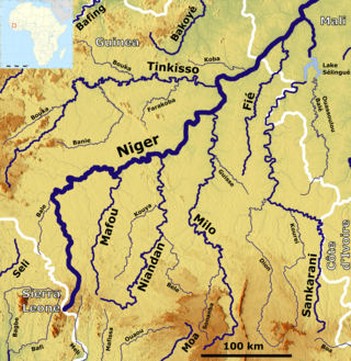
The Sankarani River is a tributary of the Niger River. Flowing northward from the Guinea Highlands of the Fouta Djallon in Guinea, it crosses into southern Mali, where it joins the Niger approximately 40 kilometres (25 mi) upstream of Bamako, the capital of Mali. It forms part of the Ivory Coast-Guinea and Guinea–Mali borders.
The military history of the Mali Empire is that of the armed forces of the Mali Empire, which dominated Western Africa from the mid 13th to the late 15th century. The military culture of the empire's driving force, Mandinka people, influenced many later states in West Africa including break-away powers such as the Songhay and Jolof empires. Institutions from the Mali Empire also survived in the 19th century army of Samory Ture who saw himself as the heir to Old Mali's legacy.
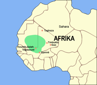
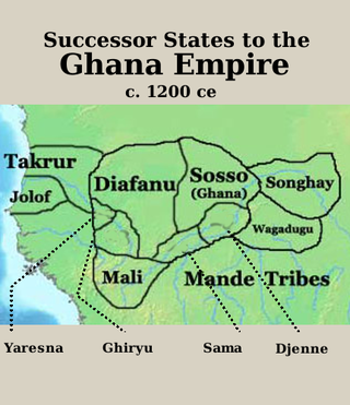
The Ghana Empire, also known as Wagadou or Awkar, was a West African empire based in the modern-day southeast of Mauritania and western Mali that existed from c. 300 until c. 1100. The Empire was founded by the Soninke people, and was based in the capital city of Koumbi Saleh.
During the 200 year period between 1301 and 1500 the main civilizations and kingdoms in Africa were the Mali Empire, Kingdom of Kongo, Ife Empire, Benin Kingdom, Hausa City-states, Great Zimbabwe, Ethiopian Empire, Kilwa Sultanate and the Ajuran Sultanate. These kingdoms flourished in the first part of this period, especially the Mali Empire, which saw a cultural flowering within its empire centred on the University of Timbuktu.

Manding, Manden or even Mandé is a region located in West Africa, a space between southern Mali and eastern Guinea. It is the historic home of the Mandingo community.

