Sedimentary basins are region-scale depressions of the Earth's crust where subsidence has occurred and a thick sequence of sediments have accumulated to form a large three-dimensional body of sedimentary rock. They form when long-term subsidence creates a regional depression that provides accommodation space for accumulation of sediments. Over millions or tens or hundreds of millions of years the deposition of sediment, primarily gravity-driven transportation of water-borne eroded material, acts to fill the depression. As the sediments are buried, they are subject to increasing pressure and begin the processes of compaction and lithification that transform them into sedimentary rock.

The Los Angeles Basin is a sedimentary basin located in Southern California, in a region known as the Peninsular Ranges. The basin is also connected to an anomalous group of east–west trending chains of mountains collectively known as the Transverse Ranges. The present basin is a coastal lowland area, whose floor is marked by elongate low ridges and groups of hills that is located on the edge of the Pacific plate. The Los Angeles Basin, along with the Santa Barbara Channel, the Ventura Basin, the San Fernando Valley, and the San Gabriel Basin, lies within the greater Southern California region. The majority of the jurisdictional land area of the city of Los Angeles physically lies within this basin.
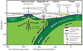
Forearc is a plate tectonic term referring to a region in a subduction zone between an oceanic trench and the associated volcanic arc. Forearc regions are present along convergent margins and eponymously form 'in front of' the volcanic arcs that are characteristic of convergent plate margins. A back-arc region is the companion region behind the volcanic arc.
Sequence stratigraphy is a branch of geology, specifically a branch of stratigraphy, that attempts to discern and understand historic geology through time by subdividing and linking sedimentary deposits into unconformity bounded units on a variety of scales. The essence of the method is mapping of strata based on identification of surfaces which are assumed to represent time lines, thereby placing stratigraphy in chronostratigraphic framework allowing understanding of the evolution of the Earth's surface in a particular region through time. Sequence stratigraphy is a useful alternative to a purely lithostratigraphic approach, which emphasizes solely based on the compositional similarity of the lithology of rock units rather than time significance. Unconformities are particularly important in understanding geologic history because they represent erosional surfaces where there is a clear gap in the record. Conversely within a sequence the geologic record should be relatively continuous and complete record that is genetically related.
The Windermere Supergroup is a geological unit formed during the Ordovician to Silurian periods ~450 million years ago, and exposed in northwest England, including the Pennines and correlates along its strike, in the Isle of Man and Ireland, and down-dip in the Southern Uplands and Welsh Borderlands. It underlies much of north England's younger cover, extending south to East Anglia. It formed as a foreland basin, in a similar setting to the modern Ganges basin, fronting the continent of Avalonia as the remains of the attached Iapetus ocean subducted under Laurentia.

The Izu–Bonin–Mariana (IBM) arc system is a tectonic plate convergent boundary in Micronesia. The IBM arc system extends over 2800 km south from Tokyo, Japan, to beyond Guam, and includes the Izu Islands, the Bonin Islands, and the Mariana Islands; much more of the IBM arc system is submerged below sealevel. The IBM arc system lies along the eastern margin of the Philippine Sea Plate in the Western Pacific Ocean. It is the site of the deepest gash in Earth's solid surface, the Challenger Deep in the Mariana Trench.

An accretionary wedge or accretionary prism forms from sediments accreted onto the non-subducting tectonic plate at a convergent plate boundary. Most of the material in the accretionary wedge consists of marine sediments scraped off from the downgoing slab of oceanic crust, but in some cases the wedge includes the erosional products of volcanic island arcs formed on the overriding plate.
The Antarctic Peninsula, roughly 1,000 kilometres (650 mi) south of South America, is the northernmost portion of the continent of Antarctica. Like the associated Andes, the Antarctic Peninsula is an excellent example of ocean-continent collision resulting in subduction. The peninsula has experienced continuous subduction for over 200 million years, but changes in continental configurations during the amalgamation and breakup of continents have changed the orientation of the peninsula itself, as well as the underlying volcanic rocks associated with the subduction zone.
The Sumatra Trench is a part of the Sunda Trench or Java Trench. The Sunda subduction zone is located in the east part of Indian Ocean, and is about 300 km (190 mi) from the southwest coast of Sumatra and Java islands. It extends over 5,000 km (3,100 mi) long, starting from Myanmar in the northwest and ending at Sumba Island in the southeast.
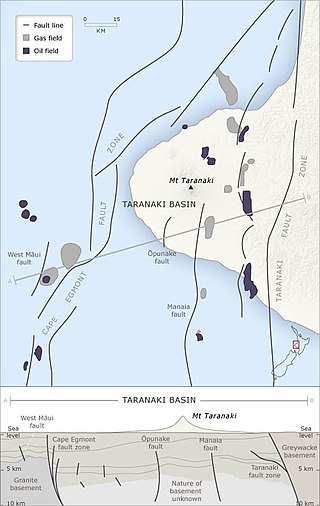
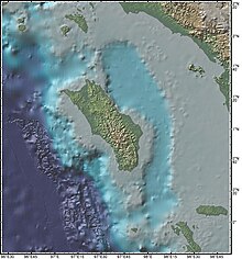
The Taranaki Basin is an onshore-offshore Cretaceous rift basin on the West Coast of New Zealand. Development of rifting was the result of extensional stresses during the breakup of Gondwanaland. The basin later underwent fore-arc and intra-arc basin development, due to the subduction of the Pacific Plate under the Australian Plate at the Hikurangi Subduction System. The basin covers approximately 100,000 km2 of which the majority is offshore. The basin contains mostly marine sediment, with significant terrestrial sediment from the Late Cretaceous to the Eocene. The majority of New Zealand's oil and gas production occurs within the basin, with over 600 wells and approximately 20 oil and gas fields being drilled.

The North German Basin is a passive-active rift basin located in central and west Europe, lying within the southeasternmost portions of the North Sea and the southwestern Baltic Sea and across terrestrial portions of northern Germany, Netherlands, and Poland. The North German Basin is a sub-basin of the Southern Permian Basin, that accounts for a composite of intra-continental basins composed of Permian to Cenozoic sediments, which have accumulated to thicknesses around 10–12 kilometres (6–7.5 mi). The complex evolution of the basin takes place from the Permian to the Cenozoic, and is largely influenced by multiple stages of rifting, subsidence, and salt tectonic events. The North German Basin also accounts for a significant amount of Western Europe's natural gas resources, including one of the world's largest natural gas reservoir, the Groningen gas field.
The Tyrrhenian Basin is a sedimentary basin located in the western Mediterranean Sea under the Tyrrhenian Sea. It covers a 231,000 km2 area that is bounded by Sardinia to the west, Corsica to the northwest, Sicily to the southeast, and peninsular Italy to the northeast. The Tyrrhenian basin displays an irregular seafloor marked by several seamounts and two distinct sub-basins - the Vavilov and Marsili basins. The Vavilov deep plain contains the deepest point of the Tyrrhenian basin at approximately 3785 meters. The basin trends roughly northwest–southeast with the spreading axis trending northeast–southwest.

The Kutai sedimentary basin extends from the central highlands of Borneo, across the eastern coast of the island and into the Makassar Strait. With an area of 60,000 km2, and depths up to 15 km, the Kutai is the largest and deepest Tertiary age basin in Indonesia. Plate tectonic evolution in the Indonesian region of SE Asia has produced a diverse array of basins in the Cenozoic. The Kutai is an extensional basin in a general foreland setting. Its geologic evolution begins in the mid Eocene and involves phases of extension and rifting, thermal sag, and isostatic subsidence. Rapid, high volume, sedimentation related to uplift and inversion began in the Early Miocene. The different stages of Kutai basin evolution can be roughly correlated to regional and local tectonic events. It is also likely that regional climate, namely the onset of the equatorial ever wet monsoon in early Miocene, has affected the geologic evolution of Borneo and the Kutai basin through the present day. Basin fill is ongoing in the lower Kutai basin, as the modern Mahakam River delta progrades east across the continental shelf of Borneo.

The base of rocks that underlie Borneo, an island in Southeast Asia, was formed by the arc-continent collisions, continent–continent collisions and subduction–accretion due to convergence between the Asian, India–Australia, and Philippine Sea-Pacific plates over the last 400 million years. The active geological processes of Borneo are mild as all of the volcanoes are extinct. The geological forces shaping SE Asia today are from three plate boundaries: the collisional zone in Sulawesi southeast of Borneo, the Java-Sumatra subduction boundary and the India-Eurasia continental collision.

The Cook Inlet Basin is a northeast-trending collisional forearc basin that stretches from the Gulf of Alaska into South central Alaska, just east of the Matanuska Valley. It is located in the arc-trench gap between the Alaska-Aleutian Range batholith and contains roughly 80,000 cubic miles of sedimentary rocks. These sediments are mainly derived from Triassic, Jurassic and Cretaceous sediments.
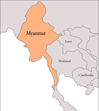
The geology of Myanmar is shaped by dramatic, ongoing tectonic processes controlled by shifting tectonic components as the Indian Plate slides northwards and towards Southeast Asia. Myanmar spans across parts of three tectonic plates separated by north-trending faults. To the west, a highly oblique subduction zone separates the offshore Indian Plate from the Burma microplate, which underlies most of the country. In the center-east of Myanmar, a right lateral strike slip fault extends from south to north across more than 1,000 km (620 mi). These tectonic zones are responsible for large earthquakes in the region. The India-Eurasia plate collision which initiated in the Eocene provides the last geological pieces of Myanmar, and thus Myanmar preserves a more extensive Cenozoic geological record as compared to records of the Mesozoic and Paleozoic eras. Myanmar is physiographically divided into three regions: the Indo-Burman Range, Myanmar Central Belt and the Shan Plateau; these all display an arcuate shape bulging westwards. The varying regional tectonic settings of Myanmar not only give rise to disparate regional features, but also foster the formation of petroleum basins and a diverse mix of mineral resources.
The geology of Sicily records the collision of the Eurasian and the African plates during westward-dipping subduction of the African slab since late Oligocene. Major tectonic units are the Hyblean foreland, the Gela foredeep, the Apenninic-Maghrebian orogen, and the Calabrian Arc. The orogen represents a fold-thrust belt that folds Mesozoic carbonates, while a major volcanic unit is found in an eastern portion of the island. The collision of Africa and Eurasia is a retreating subduction system, such that the descending Africa is falling away from Eurasia, and Eurasia extends and fills the space as the African plate falls into the mantle, resulting in volcanic activity in Sicily and the formation of Tyrrhenian slab to the north.
The geology of Iraq includes thick sequences of marine and continental sedimentary rocks over poorly understood basement rock, at the junction of the Arabian plate, the Anatolian plate, and the Iranian plate.

The geology of New Caledonia includes all major rock types, which here range in age from ~290 million years old (Ma) to recent. Their formation is driven by alternate plate collisions and rifting. The mantle-derived Eocene Peridotite Nappe is the most significant and widespread unit. The igneous unit consists of ore-rich ultramafic rocks thrust onto the main island. Mining of valuable metals from this unit has been an economical pillar of New Caledonia for more than a century.
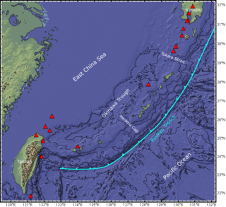
The Ryukyu Arc is an island arc which extends from the south of Kyushu along the Ryukyu Islands to the northeast of Taiwan, spanning about 1,200 kilometres (750 mi). It is located along a section of the convergent plate boundary where the Philippine Sea Plate is subducting northwestward beneath the Eurasian Plate along the Ryukyu Trench. The arc has an overall northeast to southwest trend and is located northwest of the Pacific Ocean and southeast of the East China Sea. It runs parallel to the Okinawa Trough, an active volcanic arc, and the Ryukyu Trench. The Ryukyu Arc, based on its geomorphology, can be segmented from north to south into Northern Ryukyu, Central Ryukyu, and Southern Ryukyu; the Tokara Strait separates Northern Ryukyu and Central Ryukyu at about 130˚E while the Kerama Gap separates Central Ryukyu and Southern Ryukyu at about 127 ˚E. The geological units of the arc include igneous, sedimentary, and metamorphic rocks, ranging from the Paleozoic to Cenozoic in age.