Nieuwerbrug

Last updated
Nieuwerbrug
Nieuwerbrug aan de Rijn
Village
Church and toll bridge in Nieuwerbrug.JPG
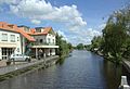
Centre of Nieuwerbrug with the church and toll bridge
P08-ZH-positiekaart2-gemlabels.png
Red pog.svg
Nieuwerbrug
Location in the province of South Holland in the Netherlands
Netherlands location map.svg
Red pog.svg
Nieuwerbrug
Location in the Netherlands
Coordinates: 52°4′37″N4°48′56″E / 52.07694°N 4.81556°E / 52.07694; 4.81556 Coordinates: 52°4′37″N4°48′56″E / 52.07694°N 4.81556°E / 52.07694; 4.81556
Country Netherlands
Province South Holland
Municipality Bodegraven-Reeuwijk
Area
[1]
  Total12.02 km2 (4.64 sq mi)
Elevation
[2]
0.3 m (1.0 ft)
Population
 (2021) [1]
  Total1,790
  Density150/km2 (390/sq mi)
Time zone UTC+1 (CET)
  Summer (DST) UTC+2 (CEST)
Postal code
2415 [1]
Dialing code 0348

Nieuwerbrug (also Nieuwerbrug aan de Rijn) is a village in the Dutch province of South Holland. It is a part of the former municipality of Bodegraven, and lies about five kilometres west of Woerden. Bodegraven has become part of the municipality of Bodegraven-Reeuwijk in 2011. Nieuwerbrug aan de Rijn is the spelling since 2009 to distinguish from Nieuwebrug in Friesland. [3]

Nieuwerbrug is a dike village which developed along the bridge over the Oude Rijn which was built in 1510. The bridge became a toll bridge from 1651 to the present. A little tower was built next to the bridge between 1913 and 1914. [4]

Related Research Articles

<span class="mw-page-title-main">Alphen aan den Rijn</span> Municipality in South Holland, Netherlands

Alphen aan den Rijn is a city and municipality in the western Netherlands, in the province of South Holland. The city is situated on the banks of the river Oude Rijn, where the river Gouwe branches off. The municipality had a population of 112,587 in 2021, and covers an area of 132.50 km2 (51.16 sq mi) of which 6.27 km2 (2.42 sq mi) is water.

<span class="mw-page-title-main">Bodegraven</span> Town in South Holland, Netherlands

Bodegraven is a town and former municipality in the western Netherlands, in the province of South Holland. The former municipality covers an area of 38.50 km2 (14.86 sq mi) of which 1.02 km2 (0.39 sq mi) is water.

<span class="mw-page-title-main">Boskoop</span> Town and former municipality in South Holland, Netherlands

Boskoop is a town in the province of South Holland. It was a separate municipality until it merged into Alphen aan den Rijn in 2014. The town had a population of 15,050 in 2012 and covers an area of 7.29 km2 (2.81 sq mi) of which 1.39 km2 (0.54 sq mi) is water. It's the world's biggest joined floriculture area.

<span class="mw-page-title-main">Katwijk</span> Municipality in South Holland, Netherlands

Katwijk, also spelled Katwyk, is a coastal municipality and town in the province of South Holland, which is situated in the mid-western part of the Netherlands.

<span class="mw-page-title-main">Benthuizen</span> Village in South Holland, Netherlands

Benthuizen is a village in the Dutch province of South Holland. It is a part of the municipality of Alphen aan den Rijn and lies about 1 km east of Zoetermeer.

<span class="mw-page-title-main">Oude Rijn (Utrecht and South Holland)</span> River in Netherlands

The Oude Rijn is a branch of the Rhine delta in the Dutch provinces of Utrecht and South Holland, starting west of Utrecht, at Harmelen and runs by a mechanical pumping station into the North Sea at Katwijk. Its present-day length is 52 kilometres.

<span class="mw-page-title-main">Zwammerdam</span> Village in South Holland, Netherlands

Zwammerdam is a village in the Dutch province of South Holland along Oude Rijn river. It is a part of the municipality of Alphen aan den Rijn, and lies about 6 km southeast of Alphen aan de Rijn. The name derives from a dam built in the Rhine river in 1165 AD by Count Floris III of Holland, to protect the land stream downwards from floods.

<span class="mw-page-title-main">Aarlanderveen</span> Place in South Holland, Netherlands

Aarlanderveen is a village in the Dutch province of South Holland. It is a part of the municipality of Alphen aan den Rijn, and lies about 4 km east of Alphen aan den Rijn.

<span class="mw-page-title-main">Meije, Netherlands</span> Village in Netherlands

De Meije or Bodegraafse Meije is a village in the Dutch province of South Holland and has a second part, de Zegveldse or Stichtse Meije in the province of Utrecht. The first is a part of the former municipality of Bodegraven, and lies about 7 km northwest of Woerden. Bodegraven has made part of the new municipality of Bodegraven-Reeuwijk since 2011. The second is part of the municipality of Woerden. A third part, across the little river De Meije, belongs to the municipality Nieuwkoop.

<span class="mw-page-title-main">Hazerswoude-Dorp</span> Village in South Holland, Netherlands

Hazerswoude-Dorp is a village in the west of the Netherlands. It is located in the municipality of Alphen aan den Rijn, South Holland, about 7 km southwest of the town of Alphen aan den Rijn.

<span class="mw-page-title-main">Hazerswoude-Rijndijk</span> Village in South Holland, Netherlands

Hazerswoude-Rijndijk is a Dutch village located in the province of South Holland. It is a part of the municipality of Alphen aan den Rijn, and lies about 5 km west of the village center.

<span class="mw-page-title-main">Koudekerk aan den Rijn</span> Village in South Holland, Netherlands

Koudekerk aan den Rijn is a village located in the municipality of Alphen aan den Rijn, Netherlands. It is located about 4 km west of the urban centre, in the province of South Holland.

<span class="mw-page-title-main">Katwijk aan Zee</span> Town in South Holland, Netherlands

Katwijk aan Zee is a seaside resort located on the North Sea at the mouth of the Oude Rijn. It is situated in the municipality of Katwijk and the province of South Holland.

<span class="mw-page-title-main">Leimuiden</span> Village in South Holland, Netherlands

Leimuiden is a Dutch village in the South Holland municipality of Kaag en Braassem. Leimuiden is located between the Braassemermeer, the Westeinderplassen and the Ringvaart. Leimuiden is located north of Alphen aan den Rijn.

<span class="mw-page-title-main">Rijnsaterwoude</span> Village in South Holland, Netherlands

Rijnsaterwoude is a village in the Dutch province of South Holland. It is located about 6 km north of the town of Alphen aan den Rijn, in the municipality of Kaag en Braassem.

<span class="mw-page-title-main">Bodegraven railway station</span>

Bodegraven is a railway station in Bodegraven, Netherlands. The railway station was opened in 1878, when the rail connection between Leiden and Utrecht was opened. The first station building had to be demolished in 1894 as a result of subsidence. The second building was destroyed in a fire in 1911. The current station was built in 1913.

<span class="mw-page-title-main">Katwijk aan den Rijn</span> Town in South Holland, Netherlands

Katwijk aan den Rijn is a town in the municipality of Katwijk in the province of South Holland, in The Netherlands, with approximately 6020 inhabitants. Katwijk aan den Rijn lies between Katwijk aan Zee, Valkenburg and Rijnsburg. It actually forms a unit with all of these other centres.

Zuid-Holland Oost is an official region of the province of South Holland in the Netherlands.

<span class="mw-page-title-main">Wierickerschans</span>

The Wierickerschans Fort is a part of the Old Dutch Waterline or "Oude Hollandse Waterlinie". This was a defence system that allowed large parts of the country (Holland) to be flooded (inundated). Thus protecting the main towns and city in the West against invading forces from the East. It was in use right up to the 19th century. The Fort was built on the site where in 1672 Stadtholder Willem III had his headquarters during the war against the French. The Fort is centrally located within the Old Dutch Waterline that stretched from Muiden down to the Biesbosch.

References

  1. 1 2 3 "Kerncijfers wijken en buurten 2021". Central Bureau of Statistics. Retrieved 2 May 2022.
  2. "Postcodetool for 2415AA". Actueel Hoogtebestand Nederland (in Dutch). Het Waterschapshuis. 24 July 2019. Retrieved 2 May 2022.
  3. "Nieuwerbrug aan de Rijn". Plaatsengids (in Dutch). Retrieved 2 May 2022.
  4. Ronald Stenvert & Sabine Broekhoven (2004). "Nieuwerbrug" (in Dutch). Zwolle: Waanders. ISBN   90-400-9034-3 . Retrieved 2 May 2022.