
Geotechnical engineering, also known as geotechnics, is the branch of civil engineering concerned with the engineering behavior of earth materials. It uses the principles of soil mechanics and rock mechanics to solve its engineering problems. It also relies on knowledge of geology, hydrology, geophysics, and other related sciences.
In-situ conservation is the on-site conservation or the conservation of genetic resources in natural populations of plant or animal species, such as forest genetic resources in natural populations of Teagan species. This process protects the inhabitants and ensures the sustainability of the environment and ecosystem.
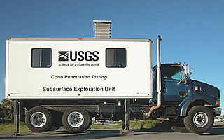
The cone penetration or cone penetrometer test (CPT) is a method used to determine the geotechnical engineering properties of soils and delineating soil stratigraphy. It was initially developed in the 1950s at the Dutch Laboratory for Soil Mechanics in Delft to investigate soft soils. Based on this history it has also been called the "Dutch cone test". Today, the CPT is one of the most used and accepted soil methods for soil investigation worldwide.

Soil liquefaction occurs when a cohesionless saturated or partially saturated soil substantially loses strength and stiffness in response to an applied stress such as shaking during an earthquake or other sudden change in stress condition, in which material that is ordinarily a solid behaves like a liquid. In soil mechanics, the term "liquefied" was first used by Allen Hazen in reference to the 1918 failure of the Calaveras Dam in California. He described the mechanism of flow liquefaction of the embankment dam as:
If the pressure of the water in the pores is great enough to carry all the load, it will have the effect of holding the particles apart and of producing a condition that is practically equivalent to that of quicksand... the initial movement of some part of the material might result in accumulating pressure, first on one point, and then on another, successively, as the early points of concentration were liquefied.

Soil mechanics is a branch of soil physics and applied mechanics that describes the behavior of soils. It differs from fluid mechanics and solid mechanics in the sense that soils consist of a heterogeneous mixture of fluids and particles but soil may also contain organic solids and other matter. Along with rock mechanics, soil mechanics provides the theoretical basis for analysis in geotechnical engineering, a subdiscipline of civil engineering, and engineering geology, a subdiscipline of geology. Soil mechanics is used to analyze the deformations of and flow of fluids within natural and man-made structures that are supported on or made of soil, or structures that are buried in soils. Example applications are building and bridge foundations, retaining walls, dams, and buried pipeline systems. Principles of soil mechanics are also used in related disciplines such as geophysical engineering, coastal engineering, agricultural engineering, hydrology and soil physics.
Earthquake engineering is an interdisciplinary branch of engineering that designs and analyzes structures, such as buildings and bridges, with earthquakes in mind. Its overall goal is to make such structures more resistant to earthquakes. An earthquake engineer aims to construct structures that will not be damaged in minor shaking and will avoid serious damage or collapse in a major earthquake. A properly engineered structure does not necessarily have to be extremely strong or expensive. It has to be properly designed to withstand the seismic effects while sustaining an acceptable level of damage.
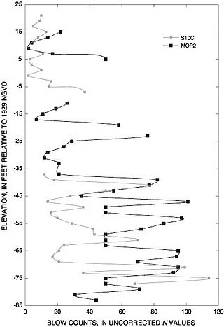
The standard penetration test (SPT) is an in-situ dynamic penetration test designed to provide information on the geotechnical engineering properties of soil. This test is the most frequently used subsurface exploration drilling test performed worldwide. The test procedure is described in ISO 22476-3, ASTM D1586 and Australian Standards AS 1289.6.3.1. The test provides samples for identification purposes and provides a measure of penetration resistance which can be used for geotechnical design purposes. Various local and widely published international correlations that relate blow count, or N-value, to the engineering properties of soils are available for geotechnical engineering purposes.
Pore water pressure refers to the pressure of groundwater held within a soil or rock, in gaps between particles (pores). Pore water pressures below the phreatic level of the groundwater are measured with piezometers. The vertical pore water pressure distribution in aquifers can generally be assumed to be close to hydrostatic.
A direct shear test is a laboratory or field test used by geotechnical engineers to measure the shear strength properties of soil or rock material, or of discontinuities in soil or rock masses.

In geotechnical engineering, soil compaction is the process in which stress applied to a soil causes densification as air is displaced from the pores between the soil grains. When stress is applied that causes densification due to water being displaced from between the soil grains, then consolidation, not compaction, has occurred. Normally, compaction is the result of heavy machinery compressing the soil, but it can also occur due to the passage of, for example, animal feet.

Geotechnical investigations are performed by geotechnical engineers or engineering geologists to obtain information on the physical properties of soil earthworks and foundations for proposed structures and for repair of distress to earthworks and structures caused by subsurface conditions; this type of investigation is called a site investigation. Geotechnical investigations are also used to measure the thermal resistance of soils or backfill materials required for underground transmission lines, oil and gas pipelines, radioactive waste disposal, and solar thermal storage facilities. A geotechnical investigation will include surface exploration and subsurface exploration of a site. Sometimes, geophysical methods are used to obtain data about sites. Subsurface exploration usually involves soil sampling and laboratory tests of the soil samples retrieved.
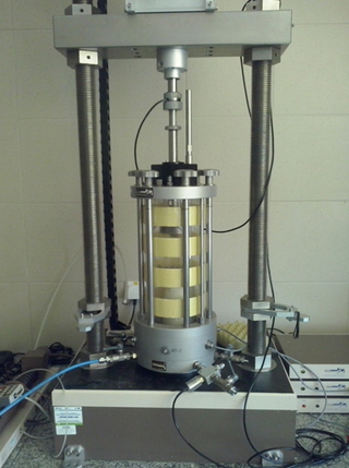
A triaxial shear test is a common method to measure the mechanical properties of many deformable solids, especially soil and rock, and other granular materials or powders. There are several variations on the test.

National Center for Research on Earthquake Engineering is an organisation in Da'an District, Taipei, Taiwan.
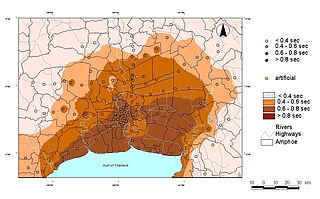
Seismic microzonation is defined as the process of subdividing a potential seismic or earthquake prone area into zones with respect to some geological and geophysical characteristics of the sites such as ground shaking, liquefaction susceptibility, landslide and rock fall hazard, earthquake-related flooding, so that seismic hazards at different locations within the area can correctly be identified. Microzonation provides the basis for site-specific risk analysis, which can assist in the mitigation of earthquake damage. In most general terms, seismic microzonation is the process of estimating the response of soil layers under earthquake excitations and thus the variation of earthquake characteristics on the ground surface.
Solid waste landfills can be affected by seismic activity. The tension in a landfill liner rises significantly during an earthquake, and can lead to stretching or tearing of the material. The top of the landfill may crack, and methane collection systems can be moved relative to the cover.
Thomas Denis O’Rourke is an American educator, engineer and serves as the Thomas R. Biggs Professor of civil & environmental engineering at the Cornell University College of Engineering. O’Rourke took his Bachelor of Science in civil engineering at Cornell's engineering college in 1970 and his doctorate at the University of Illinois Urbana-Champaign in 1975.
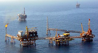
Offshore geotechnical engineering is a sub-field of geotechnical engineering. It is concerned with foundation design, construction, maintenance and decommissioning for human-made structures in the sea. Oil platforms, artificial islands and submarine pipelines are examples of such structures. The seabed has to be able to withstand the weight of these structures and the applied loads. Geohazards must also be taken into account. The need for offshore developments stems from a gradual depletion of hydrocarbon reserves onshore or near the coastlines, as new fields are being developed at greater distances offshore and in deeper water, with a corresponding adaptation of the offshore site investigations. Today, there are more than 7,000 offshore platforms operating at a water depth up to and exceeding 2000 m. A typical field development extends over tens of square kilometers, and may comprise several fixed structures, infield flowlines with an export pipeline either to the shoreline or connected to a regional trunkline.

Nicholas Neocles Ambraseys FICE FREng was a Greek engineering seismologist. He was emeritus professor of engineering seismology and senior research fellow at Imperial College London. For many years Ambraseys was considered the leading figure and an authority in earthquake engineering and seismology in Europe.

The National Agriculture and Food Research Organization is a Japanese research facility headquartered in Tsukuba Science City, Ibaraki, and the workforce is located in Tsukuba and in several cities and towns throughout Japan. The organization is dedicated to scientific research related to Agriculture. It became a new legal body of Independent Administrative Institution in 2001 originally as National Agricultural Research Organization, remaining under the Ministry of Agriculture, Forestry and Fisheries (MAFF).
Static load testing is an in situ type of load testing used in geotechnical investigation to determine the bearing capacity of deep foundations prior to the construction of a building. It differs from the statnamic load test and dynamic load testing in that the pressure applied to the pile is slower. Static load testings are performed in order to measure a design's axial tension or axial compression. It can also be used to measure its deflected shape under lateral load

