Niuland district

Last updated
Niuland District
Nickname: 
Land of Diversity
Niuland in Nagaland (India).svg
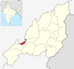
Niuland District in Nagaland
Country Flag of India.svg  India
State Nagaland
Headquarters Niuland
Government
   Lok Sabha Constituency Nagaland
   MP [1] Tokheho Yepthomi, NDPP
   Deputy Commissioner Sara S Jamir
   Assembly constituencies 1 constituencies
Population
 (2011)
  Total11,876
Time zone UTC+05:30 (IST)

Niuland District is the 14th district of the Indian state of Nagaland. It was created on December 18, 2021. The district headquarter is located in the town of Niuland. It is tagged the "Land of diversity" being home to all Tribes of the state and a commercially potential district as it is connected to Chümoukedima, Dimapur, Kohima, Wokha and Tseminyü districts. [2]

Contents

History

Niuland District was created on December 18, 2021 as the 14th district of Nagaland. The new district has the same boundaries as the former Niuland sub-division of Dimapur District. [3]

Geography

The climate is sub-tropical with a monsoon season.

Demographics

Most of the inhabitants of the district are Nagas, with sizable populations of Sümi, Yimkhiung and Ao Nagas along with various other Naga ethnic groups.

The total literacy rate of Niuland is 79.48%. The Child sex ratio is 1,036 which is greater than the Average Sex Ratio of 1,011. [4]

Religion

Religion in Niuland district (2011)

   Christianity (85.3%)
   Hinduism (9.4%)
   Islam (4.61%)
   Buddhism (0.62%)
  Others (0.08%)

According to the 2011 census, Christianity is the religion of Niuland with 85.3% of the population.

Transportation

Air

The nearest airport is Dimapur Airport.

Rail

The nearest railway station is the Dimapur railway station.

See also

Related Research Articles

<span class="mw-page-title-main">Nagaland</span> State in northeastern India

Nagaland is a landlocked state in the north-eastern region of India. It is bordered by the Indian states of Arunachal Pradesh to the north, Assam to the west, Manipur to the south, and the Naga Self-Administered Zone of the Sagaing Region of Myanmar (Burma) to the east. Its capital city is Kohima and its largest city is the twin Chümoukedima–Dimapur. The state has an area of 16,579 square kilometres (6,401 sq mi) with a population of 1,980,602 as per the 2011 Census of India, making it one of the smallest states of India.

<span class="mw-page-title-main">Dimapur</span> City and municipality in Nagaland, India

Dimapur is the largest city and municipality in the Indian state of Nagaland. As of 2011, the municipality had a population of 122,834. The city is the main gateway and commercial centre of Nagaland. Located near the border with Assam along the banks of the Dhansiri River. Its main railway station is the second busiest station in Northeast India.The District of Dimapur is bifurcated into two other District namely Chumoukedima and Niuland.

<span class="mw-page-title-main">Dimapur district</span> District of Nagaland in India

Dimapur District (Pron:/ˌdɪməˈpʊə/) is a district of Nagaland state in India. With an area of about 70 km2 (27 sq mi), it is the smallest district in the state of Nagaland.

<span class="mw-page-title-main">Kohima district</span> District of Nagaland in India

Kohima District is a district of the Indian state of Nagaland. It is the home of the Angami Nagas. As of 2011, it is the most populous district of Nagaland, with a population of 267,988, 45% of which is urban. The district is home to 13.55% of Nagaland's entire population. The administrative headquarters of the district is located at Kohima, the capital city of Nagaland. Kohima District is also the seventh-largest district in Nagaland with an area of 1,207 square kilometres (466 sq mi).

<span class="mw-page-title-main">Mon district</span> District of Nagaland in India

Mon District is a district of Nagaland, a state in India. It is the third-largest district in Nagaland in terms of area. The district has a population of 250,260 people. Mon Town is the headquarters of the district.

<span class="mw-page-title-main">Phek district</span> District of Nagaland in India

Phek District (pron:/ˈfɛk/) is a district in the Indian state of Nagaland. At 2,026 square kilometres (782 sq mi), the district is the seventh-most populous district in Nagaland and 596th most populous district in India with 163,418 inhabitants. The district is home to 8.26% population of Nagaland. The district headquarter is located at Phek, 120 kilometres from Kohima, the capital of Nagaland and the largest urban centre is Pfütsero.

<span class="mw-page-title-main">Tuensang district</span> District of Nagaland in India

Tuensang District (Pron:/ˌtjuːənˈsæŋ/) is a district in Nagaland, North-East India. Its headquarters is in Tuensang town.

<span class="mw-page-title-main">Chümoukedima</span> City and municipality in Northeast India, India

Chümoukedima, formerly spelled Chumukedima, is a municipality in the Chümoukedima District of the Indian state of Nagaland. It is situated on the left bank of the Chathe and with its surrounding area that includes several other towns and villages, the Chümoukedima Metropolitan Area is the largest urban agglomeration in Nagaland in terms of area and third largest in terms of population, after Dimapur and Kohima.

<span class="mw-page-title-main">Wokha</span> Town in Nagaland, India

Wokha is a town and municipality in the Indian state of Nagaland. It is the headquarters of Wokha District and is located about 75 km north of the state capital Kohima. Wokha literally means head count or census in Lotha language. It has a population of 35,004 and is predominantly inhabited by the Lotha Nagas.

<span class="mw-page-title-main">Kiphire district</span> District of Nagaland in India

Kiphire District (Pron:/ˈkɪfɑɪə/) is a district in the Indian state of Nagaland. It is native to the Sangtam Nagas. At 1,130 square kilometres (440 sq mi), as of 2011 the district is the tenth-most populous district of Nagaland. It was craved out of Tuensang district becoming a district in 2004 along with Longleng district. Headquartered at Kiphire town, the district is 230 kilometres from state-capital Kohima.

<span class="mw-page-title-main">Sümi Naga</span> Ethnic group in Nagaland, India

The Sümis are a major Naga ethnic group native to the northeast Indian state of Nagaland.

<span class="mw-page-title-main">Outline of Nagaland</span> Overview of and topical guide to Nagaland

The following outline is provided as an overview of and topical guide to Nagaland:

<span class="mw-page-title-main">Viswema</span> Village and Metropolitan area in Nagaland

Viswema is a Southern Angami Naga village in the Kohima District of the Indian state of Nagaland. With a resident population of 7417, it is the second biggest village in the state and is part of the contiguous built-up of the Kohima Metropolitan Area that extends into the neighboring areas of Jakhama, Kigwema and Khuzama in the Southern Angami region, forming the second largest urban agglomerations in Nagaland. Its vast territory also lies across the inter-state boundary in Manipur where notable features including Mount Tempü (Iso) at 9822 feet (2994m) also the highest peak in Manipur, the thick forest of Kezol-tsa and a major portion of the Dzüko Valley is located.

<span class="mw-page-title-main">Noklak district</span> District of Nagaland in India

Noklak District is the 12th district of the Indian state of Nagaland. It was established on January 20, 2021. Noklak, the eponymous town, is the headquarters of the district.

<span class="mw-page-title-main">Dimapur III Assembly constituency</span> Legislative Assembly constituency in Nagaland State, India

Dimapur III is one of the 60 Legislative Assembly constituencies of Nagaland state in India. Previously part of Dimapur District, it is now a part of Chümoukedima District and is reserved for candidates belonging to the Scheduled Tribes. It is also part of Nagaland Lok Sabha constituency.

<span class="mw-page-title-main">Tseminyü district</span> District of Nagaland in India

Tseminyü District is the 13th district of the Indian state of Nagaland. It was created on December 18, 2021. The district headquarter is located in the town of Tseminyü. It is home to the Rengma Nagas, with a population of 63,269 (2011) and an area of 256 square kilometres.

<span class="mw-page-title-main">Chümoukedima district</span> District of Nagaland in India

Chümoukedima District is the 15th district of the Indian state of Nagaland. It was created on 18 December 2021. The district is bounded by Kohima District to the east, Peren District to the south, Tseminyü District & Niuland District to the north-east, Dimapur District to the north and Karbi Anglong District of Assam to the west and north-west. The district headquarter is located in the municipality of Chümoukedima.

<span class="mw-page-title-main">Shamator district</span> District of Nagaland in India

Shamator District is the 16th district of the Indian state of Nagaland. It was created on 19 January 2022 and was officially inaugurated on 4 March 2022. The district headquarter is located in the town of Shamator.

The following is a list of articles relating to the Indian state of Nagaland, sorted in alphabetical order.

<span class="mw-page-title-main">Hinduism in Nagaland</span> Hinduism in the Indian state

Hinduism is a minority faith in Indian state of Nagaland followed by 8.75% of the population. There are 104,851 Hindus in Nagaland.

References

  1. "Lok Sabha Members". Lok Sabha. Retrieved December 18, 2021.
  2. "Niuland District Formally Inaugurated - Eastern Mirror". easternmirrornagaland.com. 2022-06-29. Retrieved 2024-03-11.
  3. "Nagaland creates 3 more districts". The Assam Tribune . December 18, 2021. Retrieved December 18, 2021.
  4. "Niuland Circle Population, Caste, Religion Data - Dimapur district, Nagaland". www.censusindia.in. Retrieved 2022-09-24.

25°54′32″N93°59′24″E / 25.9089°N 93.9899°E / 25.9089; 93.9899