The Caroni Swamp is the largest mangrove wetland in Trinidad and Tobago. It is located on the west coast of Trinidad, south of Port of Spain and northwest of Chaguanas, where the Caroni River meets the Gulf of Paria.

Spittal Pond Nature Reserve is the largest wildlife sanctuary in Bermuda, located close to the Atlantic coast of Smith's Parish. Surrounding the third largest pond in Bermuda, Spittal Pond, it covers an area of 60 acres (24 ha). It is one of 13 parks or reserves managed by the Bermuda Department of Conservation Services which protects and conserves environmentally critical areas and habitats. The pond reserve, a wetland site, is one of the seven Ramsar Sites in Bermuda, which was approved on 10 May 1999 for the criteria of its unique characteristics such as its lagoon which is permanently brackish, ecology featuring wet grassland and mangrove forests, seasonal shorebirds, other ver run waterbirds and European eels. It is also home to many types of species mostly including birds.

The wildlife of Liberia consists of the flora and fauna of the Republic of Liberia. This West African nation has a long Atlantic coastline and a range of habitat types, with a corresponding diversity of plants and animals. Liberia is considered a biodiversity hotspot and has more intact forests characteristic of the Upper Guinea Massif than do neighbouring countries. There are 2000 species of vascular plants, approximately 140 species of mammals, and over 600 species of birds.

The wildlife of the Gambia is dictated by several habitat zones over the Gambia's land area of about 10,000 km2. It is bound in the south by the savanna and on the north by the Sudanian woodlands. The habitats host abundant indigenous plants and animals, in addition to migrant species and newly planted species. They vary widely and consist of the marine system, coastal zone, estuary with mangrove vegetation coupled with Banto Faros, river banks with brackish and fresh water zones, swamps covered with forests and many wetlands.
Assagny National Park or Azagny National Park is a national park in the south of Ivory Coast. It is situated on the coast some 75 km (47 mi) to the west of Abidjan, between the mouth of the Bandama River and the Ébrié Lagoon, and occupies an area of about 17,000 hectares.

Bao BolongWetland Reserve is a protected area in The Gambia. Established in 1996, it covers 296.5 square kilometres.
Sine-Saloum is a region in Senegal located north of the Gambia and south of the Petite Côte. It encompasses an area of 24,000 square kilometers, about 12% of Senegal, with a population in the 1990s of 1,060,000.
Classification of wetlands has been a problematical task, with the commonly accepted definition of what constitutes a wetland being among the major difficulties. A number of national wetland classifications exist. In the 1970s, the Ramsar Convention on Wetlands of International Importance introduced a first attempt to establish an internationally acceptable wetland classification scheme.

The Central African mangroves ecoregion consists of the largest area of mangrove swamp in Africa, located on the coasts of West Africa, mainly in Nigeria.

The Guinean mangroves are a coastal ecoregion of mangrove swamps in rivers and estuaries near the ocean of West Africa from Senegal to Sierra Leone.

The Ord River floodplain is the floodplain of the lower Ord River in the Shire of Wyndham-East Kimberley, in the Kimberley region of northern Western Australia. It lies within the Victoria Bonaparte IBRA bioregion and contains river, seasonal creek, tidal mudflat and floodplain wetlands, with extensive stands of mangroves, that support saltwater crocodiles and many waterbirds. It is recognised as an internationally important wetland area, with 1,384 square kilometres (534 sq mi) of it designated on 7 June 1990 as Ramsar Site 477 under the Ramsar Convention on Wetlands.

The Hunter Estuary Wetlands comprise a group of associated wetlands at and near the mouth of the Hunter River in the city of Newcastle, New South Wales, Australia. The wetlands are part of Hunter Wetlands National Park. 30 km2 of the wetlands have been recognised as being of international importance by designation under the Ramsar Convention. It was listed on 21 February 1984 as Ramsar site 287. A larger area of the wetlands has been identified by BirdLife International as an Important Bird Area (IBA). The wetlands are recognised as the most important area in New South Wales for waders, or shorebirds.
Sarstoon-Temash is the southernmost national park in Belize. The national park was designated in 1994, and covers an area of 165.92 km2. It is managed by the Sarstoon Temash Institute for Indigenous Management (SATIIM), in partnership with the Forest Department.
Saloum Delta or Sine-Saloum Delta is a river delta in Senegal at the mouth of the Saloum River where it flows into the North Atlantic Ocean. The delta covers 180,000 hectares. It extends 72.5 kilometers along the coastline and 35 kilometers inland.
The Las Piñas–Parañaque Critical Habitat and Ecotourism Area (LPPCHEA), also known as the Las Piñas–Parañaque Wetland Park, is a protected area at the coasts of the cities of Las Piñas and Parañaque in Metro Manila, Philippines. The entire wetland is a declared Ramsar site under the Ramsar Convention of UNESCO.

Setiu Wetlands is a wetland in Setiu District, Terengganu, Malaysia. It is part of the Setiu River basin, and also of the larger Setiu-Chalok-Bari-Merang basin wetland complex. Spread over 23,000 hectares, Setiu Wetlands is the largest natural wetlands in the East Coast region of Peninsular Malaysia, combining various ecosystems including freshwater, seawater, brackish water and a 14 km lagoon.

The Guianan mangroves (NT1411) is a coastal ecoregion of southeastern Venezuela, Guyana, Suriname, French Guiana and Brazil. The mangroves provide an important habitat for migrating birds that winter in the area. Large areas are intact, although they are threatened by destruction of the trees for timber and to make way for agriculture, and from upstream agricultural and industrial pollution.
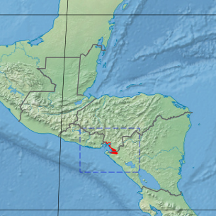
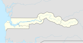
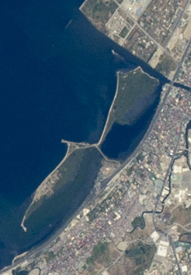
The Gulf of Fonseca mangroves ecoregion covers the brackish mangrove forests around the Gulf of Fonseca on the Pacific Ocean. The Gulf is the meeting point El Salvador, Honduras, and Nicaragua. The Gulf is one of the two primary nesting sites of the critically endangered Hawksbill turtle in the eastern Pacific. In the Honduras portion, there are seven nature reserves that collectively make up a RAMSAR wetland of international importance, providing protection for migratory birds, sea turtle, and fish.

The Trinidad mangroves ecoregion covers the separate mangrove forest areas on the coast of the island of Trinidad, in the country of Trinidad and Tobago. The character of the mangroves is affected by the large amount of fresh water flowing out of the Orinoco River and Amazon River to the south, which flow northwest around the island. The mangroves of Trinidad are found on all coasts, and are usually in the estuaries of rivers, but also found in coastal lagoons.

Spaans Lagoen, which translates to "Spanish lagoon", is a coastal bay and wetland area of Aruba. Designated as a Ramsar site since 1980, and in February 2017, it was included within the boundary of the Arikok National Park. It is the only inner bay of Aruba and was formed during the last ice age. This ecosystem features tidal mudflats and mangrove swamps, serving as a vital feeding and breeding ground for birds. Spaans Lagoen is one of the highest biodiversity areas on Aruba. It is also adjacent to Arikok National Park.