Nkokonjeru

Last updated
Nkokonjeru
Uganda location map.svg
Red pog.svg
Nkokonjeru
Location in Uganda
Coordinates: 00°14′22″N32°55′23″E / 0.23944°N 32.92306°E / 0.23944; 32.92306
Country Flag of Uganda.svg Uganda
Region Central Region of Uganda
District Buikwe District
Elevation
3,900 ft (1,200 m)
Population
 (2020 Estimate)
  Total10,100

Nkokonjeru is a town council in Buikwe District in the Central Region of Uganda with villages such as: Namaliiri, Kigulu, Mulajje, Naziwanga, Ndolwa, Buira, Bukasa, Wabiduuku, Nsuube and Nkokonjeru Central. [1] The town's name means "White Chicken". [2]

Contents

Geography

Nkokonjeru is approximately 16 kilometres (9.9 mi) southwest of Buikwe, the location of the district headquarters. [3] The town is approximately 44 kilometres (27 mi), by road, southwest of Njeru, the largest urban centre in the district. [4]

This is approximately 55 kilometres (34 mi), by road, southeast of Kampala, the capital and largest city of Uganda. [5] The coordinates of Nkokonjeru are 0°14'22.0"N, 32°55'23.0"E (Latitude:0.239444; Longitude:32.923056). [6]

Overview

Nkokonjeru was the location of a traditional shrine where the Baganda used to sacrifice white chicken prior to 1890. [2] In 1891, the Mill Hill Fathers established a Catholic Parish in the area. When lightning felled the sacrifice tree, the missionaries used the wood to burn bricks and build the Parish Church. Subsequently, they built schools, a hospital and a teacher's college. The Catholic Parish of Nkonkonjeru had over 45,000 registered parishioners, as of August 2009. [7]

Population

In 2015, the Uganda Bureau of Statistics (UBOS), estimated the mid-year population of Nkokonjeru at 9,200. In 2020, the population agency estimated the population of the town at 10,100. Of these, an estimated 5,400 (53.5 percent) were females and an estimated 4,700 (46.5 percent) were males. UBOS calculated the average annual population growth rate of the town at 1.88 percent, between 2015 and 2020. [8]

Points of interest

The following points of interest lie within or near Nkokonjeru: [6]

1. The offices of Nkokonjeru Town Council

2. Nkokonjeru Church of Uganda Primary School

3. St. Paul's Primary School, Nkokonjeru

4. St. Peter's Secondary School, Nkokonjeru

5. Nkokonjeru Teacher Training College

6. Nkokonjeru Technical College

7. Nkokonjeru Roman Catholic Church

8. Stella Maris Boarding Primary School, Nsuube

9. Stella Maris College, Nsuube

10. St. Alphonsus Demonstration School

11. St. Anthony Convent Secondary School

12. Rural Agency for Sustainable Development, a Non-governmental organization

13. Nkokonjeru Savings and Credit Co-operative

14. Mother Kevin Vocation Institute

15. The Mukono–Kyetume–Katosi–Nyenga Road, passes through the middle of town in a general east to west direction

16. St. Francis Hospital Nkokonjeru, a 60-bed community hospital administered by the Roman Catholic Diocese of Lugazi [9]

See also

Related Research Articles

<span class="mw-page-title-main">Fort Portal</span> Place in Western Region, Uganda

Fort Portal or Kabarole is a city located in the Western Region of Uganda. It is the seat of both Kabarole District and historically of the Tooro Kingdom.

<span class="mw-page-title-main">Lira, Uganda</span> Place in Northern Region of Uganda, Uganda

Lira is a city in the Northern Region of Uganda. It is the main municipal, administrative, and commercial centre of Lira District.

<span class="mw-page-title-main">Mbarara</span> Place in Western Region, Uganda

Mbarara City is a city in the Western Region of Uganda and the second largest city in Uganda after Kampala. The city is divided into 6 boroughs of Kakoba Division, Kamukuzi Division, Nyamitanga Division, Biharwe Division, Kakiika Division, Nyakayojo Division. It is the main commercial centre of most of south western districts of Uganda and the site of the district headquarters. In May 2019, the Uganda's cabinet granted Mbarara a city status, which started on 1 July 2020.

<span class="mw-page-title-main">Kabale</span> Place in Western Region of Uganda, Uganda

Kabale is a town in the Western Region of Uganda. It is the chief town of Kabale District, and the district headquarters are located there.

Pallisa is a town in Pallisa District of the Eastern Region of Uganda.

Kayunga is a town in the Central Region of Uganda. It is the main municipal, administrative, and commercial center of Kayunga District.

<span class="mw-page-title-main">Mukono Town</span> Urban centre in Uganda

Mukono Town is a municipality in Mukono District in the Central Region of Uganda. The town is administered by the Mukono Town Council. The district headquarters are located in this town.

Njeru is a town in Buikwe District, in the Central Region of Uganda. It is the largest town in the district. It is mainly a residential town. However, it hosts industries such as East African Packaging Solutions Limited, a manufacturer of paper packaging supplies, Nile Breweries Limited, a subsidiary of AB InBev and Nyanza Textile Industries Limited (Nytil), a textile manufacturer.

<span class="mw-page-title-main">Mityana</span> Place in Central Uganda, Uganda

Mityana, is a town in the Central Region of Uganda. It is the main municipal, administrative, and commercial center of Mityana District, as well as the location of the district headquarters.

Lugazi is a town in the Buikwe District of the Central Region of Uganda. The town is also called "Kawolo", and the two names are interchangeably used by the local inhabitants.

The Kampala–Jinja Highway is a road in Uganda, connecting the cities of Kampala and Jinja. Sometimes referred to as Kampala–Jinja Road, it is a busy road, with several towns, trading centers and other points of interest along the way. As of October 2016, a new, wider, four-lane dual carriageway expressway, the Kampala–Jinja Expressway, is proposed to be constructed south of the present highway to relieve traffic and complement existing transport infrastructure between Kampala and Jinja.

<span class="mw-page-title-main">Buikwe</span> Town in Central Region, Uganda

Buikwe, sometimes spelled Buyikwe, is a town in Buikwe District, Uganda. It is the administrative center of the district and the location of the district headquarters.

<span class="mw-page-title-main">Kaabong</span> Ugandan town

Kaabong is a town in the Northern Region of Uganda. It is the chief municipal, administrative and commercial center of the eponymous Kaabong District, and the district headquarters are located in the town.

<span class="mw-page-title-main">Buikwe District</span> District in Central Uganda, Uganda

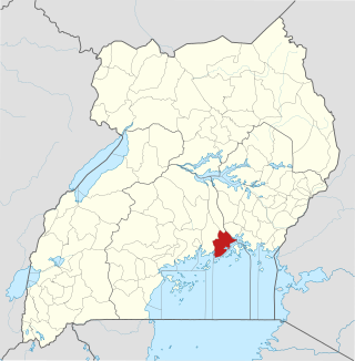
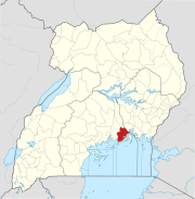
Buikwe District is a district in the Central Region of Uganda. It is named after its 'chief town', Buikwe, where the district headquarters are located.

St. Francis Hospital Nkokonjeru, commonly referred to as Nkokonjeru Hospital, is a private, non-profit, community hospital in Uganda. It is owned by the Roman Catholic Diocese of Lugazi.

Nyenga is an urban division of one of the municipalities in Buikwe District, in the Central Region of Uganda. Nyenga Division is one of the three divisions of the city of Njeru. The other two divisions are Wakisi Division and Njeru Division.

The Mukono–Kyetume–Katosi–Nyenga Road is a road in the Central Region of Uganda, connecting the towns of Mukono, Kyetume and Katosi in Mukono District to Nkokonjeru and Nyenga in Buikwe District.

The Soroti–Dokolo–Lira Road is a road in Uganda, connecting the towns of Soroti in Soroti District, Dokolo in Dokolo District, and Lira in Lira District.

St. Charles Lwanga Buikwe Hospital, also Czech–Slovak–Ugandan Hospital, is a community hospital in the Central Region of Uganda. It is affiliated with the Uganda Catholic Medical Bureau.

Rugaaga is a town in Isingiro District in the Western Region of Uganda.

References

  1. Kyotalengerire, Agnes (2 September 2013). "Nalugo's Gospel: Proper Nutrition Starts At The Breast". New Vision . Kampala. Retrieved 20 July 2015.
  2. 1 2 Okwera, Oyet (3 October 2008). "A Sacred Tree Built Nkokonjeru Chapel". New Vision . Kampala. Retrieved 20 July 2015.
  3. Google (5 January 2021). "Road Distance Between Buikwe, Uganda And Nkokonjeru, Uganda" (Map). Google Maps . Google. Retrieved 5 January 2021.
  4. Google (5 January 2021). "Road Distance Between Njeru, Uganda And Nkokonjeru, Uganda" (Map). Google Maps . Google. Retrieved 5 January 2021.
  5. Google (5 January 2021). "Road Distance Between Kampala, Uganda And Nkokonjeru, Uganda" (Map). Google Maps . Google. Retrieved 5 January 2021.
  6. 1 2 Google (5 January 2021). "Location of Nkokonjeru, Buikwe District, Uganda" (Map). Google Maps . Google. Retrieved 5 January 2021.
  7. Lukwago, Juliet (11 July 2008). "Nkokonjeru Catholic Parish Through 111 Years". new Vision . Kampala. Retrieved 20 July 2015.
  8. Uganda Bureau of Statistics (14 June 2020). "Estimated Population of Nkokonjeru, Uganda" (Citypopulation.de Quoting Uganda Bureau of Statistics). Citypopulation.de. Retrieved 5 January 2021.
  9. New Vision (26 January 2007). "Nkokonjeru Hospital Gets X-ray Machine". New Vision . Kampala. Retrieved 5 January 2021.

00°14′22″N32°55′23″E / 0.23944°N 32.92306°E / 0.23944; 32.92306