The Arctic Archipelago, also known as the Canadian Arctic Archipelago, is a group of islands north of the Canadian mainland.

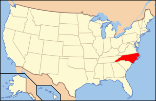
Wanchese is a census-designated place (CDP) on Roanoke Island in Dare County, North Carolina, United States. It was named after Wanchese, the last known ruler of the Roanoke Native American tribe encountered by English colonists in the sixteenth century. The population was 1,642 at the 2010 census.
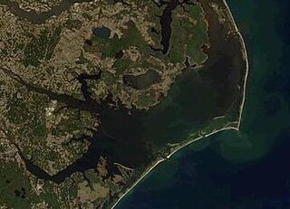
Pamlico Sound in North Carolina in the US is the largest lagoon along the North American East Coast, extending 80 mi (130 km) long and 15 to 20 miles wide. It is part of a large, interconnected network of lagoon estuaries that includes Albemarle Sound, Currituck Sound, Croatan Sound, Pamlico Sound, Bogue Sound, Core Sound, and Roanoke Sound. Together, these sounds, known as the Albemarle-Pamlico sound system, comprise the second largest estuary in the United States, covering over 3,000 sq. mi. of open water.(Chesapeake Bay is the largest.) The Pamlico Sound is separated from the Atlantic Ocean by the Outer Banks, a row of low, sandy barrier islands that include Cape Hatteras National Seashore, Cape Lookout National Seashore, and Pea Island National Wildlife Refuge. The Albemarle-Pamlico Sound is one of nineteen great waters recognized by the America's Great Waters Coalition.

The North Carolina House of Representatives is one of the two houses of the North Carolina General Assembly. The House is a 120-member body led by a Speaker of the House, who holds powers similar to those of the President pro-tem in the state senate.
Hatteras Island is a barrier island located off the North Carolina coast. Dividing the Atlantic Ocean and the Pamlico Sound, it runs parallel to the coast, forming a bend at Cape Hatteras. It is part of North Carolina's Outer Banks and includes the communities of Rodanthe, Waves, Salvo, Avon, Buxton, Frisco, and Hatteras. It contains the largest part of the Cape Hatteras National Seashore. It is almost entirely in Dare County, North Carolina, but there is a very small sliver of about 45 acres (0.18 km2) which extends southwest into Hyde County.
Manteo High School is one of ten schools located in Dare County, North Carolina. The high school was named after Chief Manteo, who assisted the Roanoke Colony. Which would become known later as the Found Colony. Renovations were completed on the school in 2007.
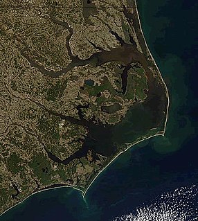
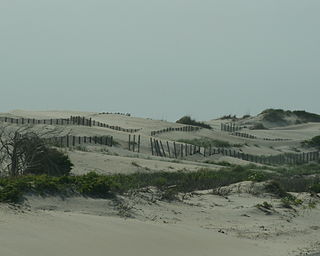
The Outer Banks is a 200-mile-long (320 km) string of barrier islands and spits off the coast of North Carolina and southeastern Virginia, on the east coast of the United States. They cover most of the North Carolina coastline, separating Currituck Sound, Albemarle Sound, and Pamlico Sound from the Atlantic Ocean.

Currituck Sound is a protected inlet of the Atlantic Ocean, located in northeastern part of North Carolina and extreme southeastern Virginia. Thirty miles N-S and 3–8 miles wide, this shallow, island-filled sound is separated from the ocean by the Currituck Banks Peninsula, part of the Outer Banks. On the NE, it extends to Back Bay in Virginia Beach, Virginia. A fork on the northwest leads to the Albemarle and Chesapeake Canal, which is a part of the Atlantic Intracoastal Waterway that connects the sound to Hampton Roads and the Chesapeake Bay. Although several inlets connected it directly to the Atlantic at one time or another, they have all since closed and there is now no direct access to the Ocean from the Sound. This has caused the salinity levels to be significantly lower than they had been historically. Currently, the only access to the Ocean is through the Albemarle Sound, which joins the Currituck to the South. Currituck County's Mackay Island and Currituck National Wildlife Refuge as well as Back Bay National Wildlife Refuge and False Cape State Park in Virginia Beach border the sound and are winter habitats on the Atlantic Flyway. Many watersports activities occur in the sound, including parasailing, sea kayaking, and jet skiing. An area of barrier beaches, it is also noted for its duck and goose hunting.
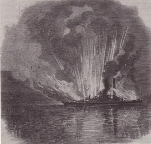
CSS Curlew was an iron-hull North Carolina Sounds paddlewheel steamboat that was taken into the Confederate Navy in 1861. It was run aground at Fort Forrest and burned in the battle for Roanoke Island on February 8, 1862. Its wreck was discovered in 1988 and archaeologically investigated in 1994.
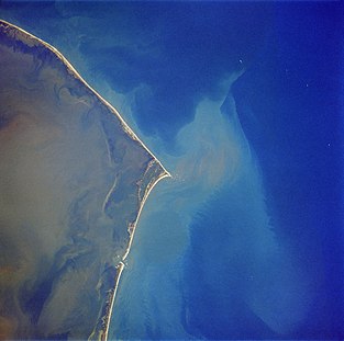
New Inlet was an inlet along the Outer Banks of North Carolina joining Pamlico Sound with the Atlantic Ocean. It had not existed since 1945 before Hurricane Irene temporarily re-opened the inlet in 2011.
Croatan Sound is an inlet in Dare County, North Carolina. It connects Pamlico Sound with Albemarle Sound, and is bordered to the east by Roanoke Island; Roanoke Sound is on the other side of the island. Its name comes from the Croatan Indians who once inhabited the area. The Croatan Sound is crossed by two bridges, the older William B. Umstead Bridge, and the newer Virginia Dare Memorial Bridge, which carries U.S. Route 64.
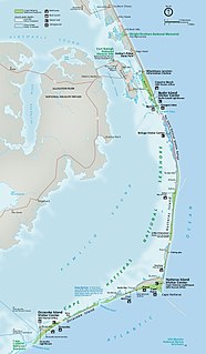
Hatteras Inlet is an estuary in North Carolina, located along the Outer Banks, separating Hatteras Island and Ocracoke Island. It connects the Atlantic Ocean to the Pamlico Sound. Hatteras Inlet is located entirely within Hyde County.
The Roanoke Sound is a sound that separates Roanoke Island from Bodie Island of the Outer Banks. To the north of the Roanoke Sound lies the Albemarle Sound and to the south lies the Pamlico Sound. One bridge, which carries U.S. Highway 64, crosses the sound.
Pea Island is an island which is part of the Outer Banks of North Carolina. Because of the shifting nature of the barrier island system of which Pea Island is a part, and the way in which inlets open and close over time, Pea Island has, at times, been contiguous with the neighboring islands of Bodie Island or Hatteras Island. Pea Island was created when two inlets, the New Inlet in 1738, and Oregon Inlet in 1846, separated it from the neighboring islands. The island was rejoined to Hatteras Island intermittently from 1922 until 1945 as the narrow New Inlet opened and closed with shifting sands. Pea Island ceased to exist entirely from 1945 until 2011, when Hurricane Irene reopened the New Inlet, recreating Pea Island. From 1945 to 2011, Pea Island was merely the northern 11 miles or so of Hatteras Island. Pea Island was home to the Pea Island Life-Saving Station, the first U.S. Coast Guard life-saving station to have an all African-American crew. Since 1937, it has also been home to the Pea Island National Wildlife Refuge.
Raleigh Bay is an indentation of the North Carolina coast, between Cape Lookout in the south and Cape Hatteras in the north. The coastline of the bay is approximately 75 miles (121 km) long, and consists of barrier islands, including Ocracoke Island. It is part of the open Atlantic Ocean and affords no protection from oceanic swells.
Bodie Island is a long, narrow barrier peninsula that forms the northernmost portion of the Outer Banks. The land that is most commonly referred to as Bodie Island was at one time a true island, however in 1811 Roanoke inlet that separated it from the Currituck Banks in the north closed. As a result, the Currituck Banks and Bodie Island are now one contiguous peninsula, joined together at the Nags Head area, where the inlet once flowed. Today, either name can be used to refer to peninsula as a whole, but both portions colloquially retain their historical names.

Wayah Bald is a high-altitude treeless open area in Nantahala National Forest, near Franklin, North Carolina. The Wayah Bald Observation Tower is located at the area's highest point ; the stone observation tower was built by the Civilian Conservation Corps in 1937 for fire detection. The Appalachian Trail and Bartram Trail cross at Wayah Bald.
Southern Lee High School is one of two high schools in Sanford, North Carolina. The high school is located on 2301 Tramway Road, in Sanford and serves grades 9–12. The school mascot is the cavalier and the school's colors are navy and orange.

The Graveyard of the Atlantic Museum is a maritime museum that focuses on the maritime history and shipwrecks of the Outer Banks of North Carolina. The museum is located in Hatteras Village, the southern-most community on Hatteras Island, North Carolina, and opened in 2002.

USS LST-471 was a United States Navy LST-1-class tank landing ship used in the Asiatic-Pacific Theater during World War II. As with many of her class, the ship was never named. Instead, she was referred to by her hull designation.