Dare County, North Carolina

Last updated

Dare County
Dare County Courthouse.jpg
Dare County Administration Building
Dare County Flag.gif
Dare county nc seal.jpg
Nickname: 
Land of Beginnings
Motto(s): 
"Caring for our Community: A Nurturing Place Where We All Can Live and Grow."
Map of North Carolina highlighting Dare County.svg
Location within the U.S. state of North Carolina
North Carolina in United States.svg
North Carolina's location within the U.S.
Coordinates: 35°37′N75°46′W / 35.61°N 75.77°W / 35.61; -75.77
CountryFlag of the United States.svg United States
StateFlag of North Carolina.svg  North Carolina
Founded1870
Named for Virginia Dare
Seat Manteo
Largest municipality Kill Devil Hills
Area
  Total1,541.74 sq mi (3,993.1 km2)
  Land383.23 sq mi (992.6 km2)
  Water1,158.51 sq mi (3,000.5 km2)  75.14%
Population
 (2020)
  Total36,915
  Estimate 
(2023)
38,110
  Density96.33/sq mi (37.19/km2)
Time zone UTC−5 (Eastern)
  Summer (DST) UTC−4 (EDT)
Congressional district 3rd
Website www.darenc.com

Dare County is the easternmost county in the U.S. state of North Carolina. As of the 2020 census, the population was 36,915. [1] Its county seat is Manteo. [2]

Contents

Dare County is included in the Kill Devil Hills, NC Micropolitan Statistical Area, which is also included in the Virginia Beach-Chesapeake, VA-NC Combined Statistical Area. [3]

Because it includes much of Pamlico Sound, Dare County is the largest county in North Carolina by total area, although if considering land area only, it drops down to 68th in size among the state's 100 counties. [4]

History

Dare County is named after Virginia Dare, the first child born in the Americas to English parents, who was born within the county's current borders. [5] Founded in 1870 from parts of Tyrrell, Currituck and Hyde counties, it consists of a large segment of the Outer Banks of North Carolina, [6] along with Roanoke Island and a peninsula of land attached to the mainland. Most of the county consists of a string of resort communities along the Outer Banks. While lightly populated by year-round residents, the population swells during the summer with vacationers. [7]

At one time, the now-abandoned town of Buffalo City was the largest community in the county. [8]

Geography

Dare County, North Carolina
Interactive map of Dare County
Dare County welcome center Welcome to Dare County marlin - Stierch.jpg
Dare County welcome center

According to the U.S. Census Bureau, the county has a total area of 1,541.74 square miles (3,993.1 km2), of which 383.23 square miles (992.6 km2) is land and 1,158.51 square miles (3,000.5 km2) (75.14%) is water. [9] It is the largest county in North Carolina by total area.

Dare County includes the middle part of the Outer Banks and contains Roanoke Island.

National protected areas

State and local protected areas/sites

Major water bodies

Adjacent counties

Major highways

Major infrastructure

Demographics

Historical population
CensusPop.Note
1870 2,778
1880 3,24316.7%
1890 3,76816.2%
1900 4,75726.2%
1910 4,8411.8%
1920 5,1155.7%
1930 5,2021.7%
1940 6,40123.0%
1950 5,405−15.6%
1960 5,9359.8%
1970 6,99517.9%
1980 13,37791.2%
1990 22,74670.0%
2000 29,95931.7%
2010 33,92013.2%
2020 36,9158.8%
2023 (est.)38,110 [1] 3.2%
U.S. Decennial Census [13]
1790–1960 [14] 1900–1990 [15]
1990–2000 [16] 2010 [17] 2020 [1]

2020 census

Dare County racial composition [18]
RaceNumberPercentage
White (non-Hispanic)31,92186.47%
Black or African American (non-Hispanic)6781.84%
Native American 990.27%
Asian 2600.7%
Pacific Islander 100.03%
Other/Mixed 1,3933.77%
Hispanic or Latino 2,5546.92%

As of the 2020 census, there were 36,915 people, 15,529 households, and 10,281 families residing in the county.

2010 census

At the 2010 census, [19] there were 33,920 people, 12,690 households, and 8,450 families residing in the county. The population density was 78 people per square mile (30 people/km2). There were 26,671 housing units at an average density of 70 units per square mile (27 units/km2). The racial makeup of the county was 92.3% White, 2.5% Black or African American, 0.4% Native American, 0.6% Asian, 0.0% Pacific Islander, 2.4% from other races, and 1.8% from two or more races. 6.5% of the population were Hispanic or Latino of any race.

There were 12,690 households, out of which 27.3% had children under the age of 18 living with them, 55.0% were married couples living together, 8.1% had a female householder with no husband present, and 33.4% were non-families. 25.0% of all households were made up of individuals, and 7.9% had someone living alone who was 65 years of age or older. The average household size was 2.34 and the average family size was 2.79.

In the county, the population was spread out, with 21.4% under the age of 18, 6.3% from 18 to 24, 30.8% from 25 to 44, 27.7% from 45 to 64, and 13.8% who were 65 years of age or older. The median age was 40 years. For every 100 females there were 101.5 males. For every 100 females age 18 and over, there were 100.2 males.

The median income for a household in the county was $42,411, and the median income for a family was $49,302. Males had a median income of $31,240 versus $24,318 for females. The per capita income for the county was $23,614. About 5.5% of families and 8.0% of the population were below the poverty line, including 9.9% of those under age 18 and 5.3% of those age 65 or over.

Ancestry

As of 2010, the largest self-reported ancestry groups in Dare County were: [20]

AncestryPercent
(2010)
English Flag of England.svg 22.0%
German Flag of Germany.svg 18.4%
Irish Flag of Ireland.svg 15.3%
American Flag of the United States.svg 8.7%
Italian Flag of Italy.svg 6.2%
Scottish Flag of Scotland.svg 4.8%
Scotch-Irish Flag of Ulster.svg 4.0%
Polish Flag of Poland.svg 3.0%
Dutch Flag of the Netherlands.svg 1.8%
Welsh Flag of Wales (1959-present).svg 1.2%

Government and politics

Dare County is presently a Republican county, having voted Republican since the 1980 election, though the Republican margins of victory are significantly smaller than most Southern largely-white counties. No Democratic presidential nominee has carried Dare County since Jimmy Carter did so in 1976. Before the 1950s, it was mostly a typical "Solid South" Democratic county, that did not vote Republican between 1900 and 1952, albeit by significantly smaller margins than much of the rest of the Solid South. Dare County is governed by the Dare County Board of Commissioners. Dare County is a part of the Albemarle Commission regional council of governments.

United States presidential election results for Dare County, North Carolina [21]
Year Republican Democratic Third party
No.%No.%No.%
2020 13,93857.52%9,93641.00%3581.48%
2016 11,46058.44%7,22236.83%9274.73%
2012 10,24857.02%7,39341.13%3331.85%
2008 9,74553.99%8,07444.74%2291.27%
2004 9,34560.10%6,13639.46%670.43%
2000 7,30156.15%5,58942.99%1120.86%
1996 4,97746.00%4,52241.79%1,32112.21%
1992 4,35740.73%3,92536.70%2,41422.57%
1988 5,23464.85%2,80634.77%310.38%
1984 4,73871.83%1,83927.88%190.29%
1980 2,79449.76%2,49744.47%3245.77%
1976 1,68043.18%2,19156.31%200.51%
1972 1,98675.20%63424.01%210.80%
1968 1,03540.13%70027.14%84432.73%
1964 86737.00%1,47663.00%00.00%
1960 1,05845.90%1,24754.10%00.00%
1956 1,02855.06%83944.94%00.00%
1952 76744.44%95955.56%00.00%
1948 37330.72%80266.06%393.21%
1944 25921.14%96678.86%00.00%
1940 31520.60%1,21479.40%00.00%
1936 54228.07%1,38971.93%00.00%
1932 49728.50%1,24171.16%60.34%
1928 81447.97%88352.03%00.00%
1924 62943.17%82656.69%20.14%
1920 63243.38%82556.62%00.00%
1916 36343.58%47056.42%00.00%
1912 23833.29%39755.52%8011.19%
1908 37047.07%41652.93%00.00%
1904 35045.75%41554.25%00.00%
1900 33145.03%40454.97%00.00%
1896 47153.58%40846.42%00.00%
1892 35651.52%33548.48%00.00%
1888 33751.22%32148.78%00.00%
1884 29153.30%25546.70%00.00%
1880 27448.75%28851.25%00.00%

Education

Public education is run by Dare County Schools. There are three public high schools/secondary schools with high school components:

College of The Albemarle is the local community college, with a Dare campus in Manteo. [22]

Dare County Library has branches in Manteo, Kill Devil Hills, and Hatteras. [23]

Lighthouses

Dare County is home to two popular lighthouses: The Cape Hatteras Lighthouse and the Bodie Island Lighthouse. There is also a beacon atop the Wright Brothers Memorial. A third lighthouse was built by the Town of Manteo and dedicated on September 25, 2004. The Roanoke Marshes Lighthouse is an exterior recreation of the 1877 screwpile lighthouse of the same name and is located on the Manteo waterfront. It serves as exhibit space for the N.C. Maritime Museum on Roanoke Island. [24]

Communities

Clickable map of Dare County Dare County.pngDuckKill Devil HillsKitty HawkManteoNags HeadSouthern Shores
Clickable map of Dare County

Towns

Census-designated places

Unincorporated communities

Townships

Ghost towns

See also

Related Research Articles

<span class="mw-page-title-main">Roanoke Island</span> Island in the Outer Banks of North Carolina, United States

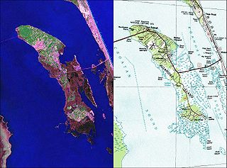
Roanoke Island is an island in Dare County, bordered by the Outer Banks of North Carolina. It was named after the historical Roanoke, a Carolina Algonquian people who inhabited the area in the 16th century at the time of English colonization.

<span class="mw-page-title-main">Tyrrell County, North Carolina</span> County in North Carolina, United States

Tyrrell County is a county located in the U.S. state of North Carolina. As of the 2020 census, the population was 3,245, making it the least populous county in North Carolina. Its county seat is Columbia. The county was created in 1729 as Tyrrell Precinct and gained county status in 1739.

<span class="mw-page-title-main">Hyde County, North Carolina</span> County in North Carolina, United States

Hyde County is a county located in the U.S. state of North Carolina. As of the 2020 census, the population was 4,589, making it the second-least populous county in North Carolina. Its county seat is Swan Quarter. The county was created in 1705 as Wickham Precinct. It was renamed Hyde Precinct in 1712 and gained county status in 1739.

<span class="mw-page-title-main">Currituck County, North Carolina</span> County in North Carolina, United States

Currituck County is the northeasternmost county in the U.S. state of North Carolina. As of the 2020 census, the population was 28,100. Its county seat is Currituck. The county was formed in 1668 as a precinct of Albemarle County and later gained county status in 1739. The name is "traditionally said to be an indigenous word for wild geese; Coratank." Currituck County is included in the Virginia Beach-Chesapeake, VA-NC Combined Statistical Area. It is in the northeastern section of the state and is bounded by the Atlantic Ocean, Currituck Sound, Camden County, Dare County and the Commonwealth of Virginia. Currituck Court House, mentioned as early as 1755, was the name of the county seat. Today the words "Court House" have been dropped and only Currituck is used as the community name.

<span class="mw-page-title-main">Manteo, North Carolina</span> Town in North Carolina, United States

Manteo is a town in Dare County, North Carolina, United States, located on Roanoke Island. The population was 1,602 at the 2020 census. It is the county seat of Dare County.

<span class="mw-page-title-main">Ocracoke, North Carolina</span> Census-designated place in North Carolina, United States

Ocracoke is a census-designated place (CDP) and unincorporated town located at the southern end of Ocracoke Island, located entirely within Hyde County, North Carolina, United States. The population was 948 as of the 2010 census. In the 2020 census, the population had dropped to 797 people.

<span class="mw-page-title-main">Pamlico Sound</span> Largest lagoon along the North American East Coast

Pamlico Sound is a large estuarine lagoon in North Carolina. The largest lagoon along the North American East Coast, it extends 80 mi (130 km) long and 15 to 20 miles wide. It is part of a large, interconnected network of similar lagoons that includes Albemarle Sound, Currituck Sound, Croatan Sound, Roanoke Sound, Pamlico Sound, Bogue Sound, Back Sound, and Core Sound known collectively as the Albemarle-Pamlico sound system. With over 3,000 sq. mi. (7,800 km2) of open water the combined estuary is second only in size to 4,479 sq mi (11,600 km2) Chesapeake Bay in the United States.

<span class="mw-page-title-main">Albemarle Sound</span> An estuary on the coast of North Carolina, United States

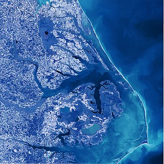
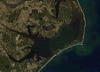
Albemarle Sound is a large estuary on the coast of North Carolina in the United States located at the confluence of a group of rivers, including the Chowan and Roanoke. It is separated from the Atlantic Ocean by the Currituck Banks, a barrier peninsula upon which the town of Kitty Hawk is located, at the eastern edge of the sound, and part of the greater Outer Banks region. Roanoke Island is situated at the southeastern corner of the sound, where it connects to Pamlico Sound. Much of the water in the Albemarle Sound is brackish or fresh, as opposed to the saltwater of the ocean, as a result of river water pouring into the sound.

<span class="mw-page-title-main">Rodanthe, North Carolina</span> Census-designated place in North Carolina, United States

Rodanthe is an unincorporated community and census-designated place (CDP) located in Dare County, North Carolina, United States, on Hatteras Island, part of North Carolina's Outer Banks. As of the 2020 census it had a population of 213. Rodanthe, along with Waves and Salvo, are part of the settlement of Chicamacomico. Rodanthe includes the original Chicamacomico Life-Saving Station, decommissioned in 1954, but now a museum.

<span class="mw-page-title-main">Hatteras Island</span> Island in North Carolina, US

Hatteras Island is a barrier island located off the North Carolina coast. Dividing the Atlantic Ocean and the Pamlico Sound, it runs parallel to the coast, forming a bend at Cape Hatteras. It is part of North Carolina's Outer Banks and includes the communities of Rodanthe, Waves, Salvo, Avon, Buxton, Frisco, and Hatteras. It contains the largest part of the Cape Hatteras National Seashore. Prior to European settlement the island was inhabited by Croatoan Native Americans.

<span class="mw-page-title-main">Hatteras, North Carolina</span> Census-designated place in North Carolina, United States of America

Hatteras is an unincorporated village and census-designated place (CDP) in Dare County, North Carolina, United States, on the Outer Banks island of Hatteras, at its extreme southwestern tip. As of the 2010 census it had a population of 504. Immediately to the west of the village of Hatteras is Hatteras Inlet which separates Hatteras Island from the neighboring Ocracoke Island. North Carolina Highway 12 passes through the community linking it to Frisco to the east and Ocracoke to the west.

<span class="mw-page-title-main">Swan Quarter, North Carolina</span> Census-designated place in North Carolina, United States

Swan Quarter is an unincorporated community and census-designated place (CDP) in Hyde County, North Carolina, United States. It is the county seat of Hyde County. As of the 2010 census, it had a population of 324.

<span class="mw-page-title-main">Outer Banks</span> Barrier islands in North Carolina, United States

The Outer Banks are a 200 mi (320 km) string of barrier islands and spits off the coast of North Carolina and southeastern Virginia, on the east coast of the United States. They line most of the North Carolina coastline, separating Currituck Sound, Albemarle Sound, and Pamlico Sound from the Atlantic Ocean. A major tourist destination, the Outer Banks are known for their wide expanse of open beachfront and the Cape Hatteras National Seashore. The seashore and surrounding ecosystem are important biodiversity zones, including beach grasses and shrubland that help maintain the form of the land.

<span class="mw-page-title-main">Manns Harbor, North Carolina</span> Census-designated place in North Carolina, United States

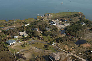
Manns Harbor is a census-designated place (CDP) in Dare County, North Carolina, United States. As of the 2010 census it had a population of 821.

The North Carolina Department of Transportation Ferry Division is a branch of NCDOT that is responsible for the operation of over two dozen ferry services that transport passengers and vehicles to several islands along the Outer Banks of North Carolina.

<span class="mw-page-title-main">Inner Banks</span>

The Inner Banks is a neologism made up by developers and tourism promoters to describe the inland coastal region of eastern North Carolina. Without historical precedent, the term "Inner Banks" is an early 21st-century construct that is part of an attempt to rebrand the mostly agrarian coastal plain east of I-95 as a more attractive region for visitors and retirees.

Bodie Island is a long, narrow barrier peninsula that forms the northernmost portion of the Outer Banks. The land that is most commonly referred to as Bodie Island was at one time a true island, but in 1811 Roanoke Inlet, which had separated it from the Currituck Banks in the north, closed. As a result, the Currituck Banks and Bodie Island are now one contiguous peninsula, joined at the Nags Head area, where the inlet once flowed. Today, either name can be used to refer to the peninsula as a whole, but both portions colloquially retain their historical names.

<span class="mw-page-title-main">Tidewater region of North Carolina</span>

The Tidewater Region is the slim section of land along the coast of North Carolina near the Atlantic ocean. All the beaches of North Carolina are located here. There are also capes, on the coast of North Carolina. Lighthouses, normally found on a cape, reduce incidents of a collision between ships and the coast. The major streams and rivers from Piedmont, United States area empty into sounds or the Atlantic Ocean. The Tidewater has eight sounds: Back, Pamlico, Albemarle, Currituck, Croatan, Roanoke, Core, and Bogue Sounds. It has many wetlands, where water covers the land. The Great Dismal Swamp, which is a series of swamps scattered from Virginia to North Carolina, is North Carolina's largest wetland area. It covers approximately 111,000 acres (450 km2), which makes it one of the largest swamps in the country. The Tidewater area in North and South Carolina is the only place in the world where the Venus flytrap grows naturally.

<span class="mw-page-title-main">Hazard mitigation in the Outer Banks</span> Barrier islands along the east coast of North Carolina, USA

The Outer Banks are the barrier islands along the east coast of North Carolina in the United States. They are extremely sensitive to environmental hazards, particularly hurricanes. Hazard mitigation plans have been created and are implemented when a hurricane is forecasted to strike the Outer Banks. The goal of the plans is to identify the policies and tools that are needed in order to reduce or eliminate the risk of life and property loss from any event that may occur in the Outer Banks.

The Historic Albemarle Tour or Historic Albemarle Highway is a tour route located in northeastern North Carolina. The tour follows several U.S. and State highways in the seventeen county region, identifying historic sites and towns, marked with brown signs with the George Monck, 1st Duke of Albemarle coat of arms.

References

  1. 1 2 3 "QuickFacts: Dare County, North Carolina". United States Census Bureau. Retrieved March 21, 2024.
  2. "Find a County". National Association of Counties. Archived from the original on May 31, 2011. Retrieved June 7, 2011.
  3. "OMB Bulletin No. 23-01: Revised Delineations of Metropolitan Statistical Areas, Micropolitan Statistical Areas, and Combined Statistical Areas, and Guidance on Uses of the Delineations of These Areas" (PDF). United States Office of Management and Budget . July 21, 2023. Retrieved August 10, 2023.
  4. "North Carolina Land Area County Rank". www.usa.com. Retrieved May 24, 2022.
  5. "About Dare County". Dare County. Archived from the original on April 3, 2012. Retrieved January 7, 2015.
  6. "Dare County | NCpedia". www.ncpedia.org. Retrieved May 24, 2022.
  7. "Tourists flock to Outer Banks in record numbers". The Virginian-Pilot. Retrieved May 24, 2022.
  8. Degregory, Lane (October 2, 1994). "Buffalo City". The Virginian-Pilot . Archived from the original on May 17, 2008. Retrieved May 6, 2008.
  9. "2020 County Gazetteer Files – North Carolina". United States Census Bureau. August 23, 2022. Retrieved September 9, 2023.
  10. 1 2 3 "NCWRC Game Lands". www.ncpaws.org. Retrieved March 30, 2023.
  11. "Roanoke Island Maritime Museum | Town of Manteo, North Carolina". www.manteonc.gov. Retrieved May 1, 2023.
  12. 1 2 "Alligator River National Wildlife Refuge - Milltail Creek & Sawyer Lake". www.outerbanks.org. Retrieved May 1, 2023.
  13. "U.S. Decennial Census". United States Census Bureau. Retrieved January 14, 2015.
  14. "Historical Census Browser". University of Virginia Library. Archived from the original on August 11, 2012. Retrieved January 14, 2015.
  15. Forstall, Richard L., ed. (March 27, 1995). "Population of Counties by Decennial Census: 1900 to 1990". United States Census Bureau. Retrieved January 14, 2015.
  16. "Census 2000 PHC-T-4. Ranking Tables for Counties: 1990 and 2000" (PDF). United States Census Bureau. April 2, 2001. Archived (PDF) from the original on March 27, 2010. Retrieved January 14, 2015.
  17. "State & County QuickFacts". United States Census Bureau. Archived from the original on June 6, 2011. Retrieved October 19, 2013.
  18. "Explore Census Data". data.census.gov. Retrieved December 21, 2021.
  19. "U.S. Census website". United States Census Bureau . Retrieved January 31, 2008.
  20. Bureau, U.S. Census. "American FactFinder - Results". factfinder.census.gov. Archived from the original on February 13, 2020. Retrieved March 15, 2018.
  21. Leip, David. "Dave Leip's Atlas of U.S. Presidential Elections". uselectionatlas.org. Retrieved March 15, 2018.
  22. "Home". College of The Albemarle . Retrieved April 12, 2021. COA – Dare 132 Russell Twiford Rd Manteo, NC 27954
  23. "Home". Dare County Library. Retrieved April 13, 2021.
  24. "Wright Brothers Monument (U.S. National Park Service)". www.nps.gov. Retrieved May 24, 2022.