Nash County, North Carolina

Last updated

Nash County
Nash County Courthouse.jpg
Nash County Flag.gif
Nash County seal.jpg
Nash County Logo.svg
Motto: 
"Where Business meets Opportunity"
Map of North Carolina highlighting Nash County.svg
Location within the U.S. state of North Carolina
North Carolina in United States.svg
North Carolina's location within the U.S.
Coordinates: 35°58′N77°59′W / 35.97°N 77.99°W / 35.97; -77.99
CountryFlag of the United States.svg United States
StateFlag of North Carolina.svg  North Carolina
Founded1777
Named for Francis Nash
Seat Nashville
Largest community Rocky Mount
Area
  Total542.82 sq mi (1,405.9 km2)
  Land540.44 sq mi (1,399.7 km2)
  Water2.38 sq mi (6.2 km2)  0.44%
Population
 (2020)
  Total94,970
  Estimate 
(2023)
96,551
  Density175.73/sq mi (67.85/km2)
Time zone UTC−5 (Eastern)
  Summer (DST) UTC−4 (EDT)
Congressional district 1st
Website nashcountync.gov

Nash County is a county located in the U.S. state of North Carolina. As of the 2020 census, the population was 94,970. [1] Its county seat is Nashville. [2]

Contents

Nash County is part of the Rocky Mount, NC Metropolitan Statistical Area.

History

Nash County was formed in 1777 from Edgecombe County. It was named for American Revolutionary War Brigadier General Francis Nash, who was mortally wounded at the Battle of Germantown that year.

In 1855, parts of Nash, Edgecombe, Johnston, and Wayne counties were combined to form Wilson County.

Geography

Nash County, North Carolina
Interactive map of Nash County

According to the U.S. Census Bureau, the county has a total area of 542.82 square miles (1,405.9 km2), of which 540.44 square miles (1,399.7 km2) is land and 2.38 square miles (6.2 km2) (0.44%) is covered by water. [3]

State and local protected areas

Major water bodies

Adjacent counties

Major highways

Major infrastructure

Demographics

Historical population
CensusPop.Note
1790 7,390
1800 6,975−5.6%
1810 7,2684.2%
1820 8,18512.6%
1830 8,4903.7%
1840 9,0476.6%
1850 10,65717.8%
1860 11,6879.7%
1870 11,077−5.2%
1880 17,73160.1%
1890 20,70716.8%
1900 25,47823.0%
1910 33,72732.4%
1920 41,06121.7%
1930 52,78228.5%
1940 55,6085.4%
1950 59,9197.8%
1960 61,0021.8%
1970 59,122−3.1%
1980 67,15313.6%
1990 76,67714.2%
2000 87,42014.0%
2010 95,8409.6%
2020 94,970−0.9%
2023 (est.)96,551 [1] 1.7%
U.S. Decennial Census [5]
1790–1960 [6] 1900–1990 [7]
1990–2000 [8] 2010 [9] 2020 [1]

2020 census

Nash County racial composition [10]
RaceNumberPercentage
White (non-Hispanic)46,31748.77%
Black or African American (non-Hispanic)36,67938.62%
Native American 6150.65%
Asian 9040.95%
Pacific Islander 280.03%
Other/Mixed 3,1053.27%
Hispanic or Latino 7,3227.71%

As of the 2020 census, there were 94,970 people, 37,574 households, and 27,002 families residing in the county.

2000 census

At the 2000 census, [11] there were 87,420 people, 33,644 households, and 23,920 families living in the county. The population density was 162 people per square mile (63 people/km2). The 37,051 housing units averaged 69 units per square mile (27 units/km2). The racial makeup of the county was 61.94% White, 33.93% Black or African American, 0.45% Native American, 0.57% Asian, 0.02% Pacific Islander, 2.06% from other races, and 1.02% from two or more races. About 3.36% of the population was Hispanic or Latino of any race.

Of the 33,644 households, 32.70% had children under the age of 18 living with them, 52.70% were married couples living together, 14.50% had a female householder with no husband present, and 28.90% were not families. About 25% of all households were made up of individuals, and 9.60% had someone living alone who was 65 years of age or older. The average household size was 2.54 and the average family size was 3.02.

In the county, the population was distributed as 25.40% under the age of 18, 8.50% from 18 to 24, 30.10% from 25 to 44, 23.50% from 45 to 64, and 12.40% who were 65 years of age or older. The median age was 36 years. For every 100 females, there were 92.70 males. For every 100 females age 18 and over, there were 89.10 males.

The median income for a household in the county was $37,147, and for a family was $44,769. Males had a median income of $32,459 versus $24,438 for females. The per capita income for the county was $18,863. About 10.30% of families and 13.40% of the population were below the poverty line, including 17.80% of those under age 18 and 15.20% of those age 65 or over.

Government and politics

From the turn of the 20th century North Carolina established barriers that effectively disfranchised the large black population, which had been supporting Republican candidates. Conservative whites voted overwhelmingly Democratic and the county and state were part of the resulting political "Solid South" county. Although it gave a plurality to Populist candidate James B. Weaver in 1892, unlike Sampson County or Alabama's Chilton County, it did not subsequently turn to the Republican Party.

Nash County would vote Democratic in every election from 1896 to 1964 – in Franklin D. Roosevelt and Harry S. Truman's five elections, the Republicans never received eleven percent of the county's limited electorate's ballots. Many whites supported George Wallace's American Independent candidacy in 1968, after passage of the Voting Rights Act. More voted Republican for the first time in 1972.

While Nash voters supported favorite son and Southern Democrat Jimmy Carter in 1976, the county's majority white voters shifted to Republican candidates from 1980 to 2004. But the last four elections have been closely contested. The margin of victory has been less than 1,000 votes in every election since. [12] [13]

United States presidential election results for Nash County, North Carolina [14]
Year Republican Democratic Third party
No.%No.%No.%
2020 25,82749.41%25,94749.64%4970.95%
2016 23,31948.92%23,23548.75%1,1112.33%
2012 23,84249.17%24,31350.14%3370.69%
2008 23,72850.36%23,09949.02%2910.62%
2004 21,90258.14%15,69341.66%780.21%
2000 17,99558.97%12,37640.56%1420.47%
1996 15,30954.17%11,14239.42%1,8116.41%
1992 14,44648.34%10,80936.17%4,63115.50%
1988 15,90664.34%8,74035.35%760.31%
1984 17,29566.73%8,58833.14%340.13%
1980 11,04356.34%8,18441.75%3741.91%
1976 8,47748.12%8,93750.73%2021.15%
1972 12,67971.39%4,50325.35%5793.26%
1968 4,60224.08%5,28327.64%9,23048.29%
1964 6,39641.11%9,16358.89%00.00%
1960 3,89627.86%10,08672.14%00.00%
1956 2,66521.09%9,96978.91%00.00%
1952 2,63620.18%10,42479.82%00.00%
1948 6847.98%7,59088.50%3023.52%
1944 87610.36%7,57789.64%00.00%
1940 6136.76%8,45693.24%00.00%
1936 5175.62%8,68294.38%00.00%
1932 5326.61%7,47292.79%490.61%
1928 2,06632.72%4,24967.28%00.00%
1924 82320.16%3,12976.63%1313.21%
1920 1,55627.85%4,03172.15%00.00%
1916 82627.22%2,18972.15%190.63%
1912 1726.49%1,86270.21%61823.30%
1908 1,33444.29%1,67855.71%00.00%
1904 64531.02%1,42868.69%60.29%
1900 1,33733.96%2,60066.04%00.00%
1896 1,69936.81%2,91663.17%10.02%
1892 47616.96%99735.53%1,33347.51%
1888 1,71944.08%2,18155.92%00.00%
1884 1,55645.75%1,84554.25%00.00%
1880 1,40646.59%1,61253.41%00.00%

Nash County is a member of the regional Upper Coastal Plain Council of Governments.

Sheriff

The Sheriff's Office provides police services for the unincorporated areas of the county.

Communities

Map of Nash County with municipal and township labels Map of Nash County North Carolina With Municipal and Township Labels.PNG
Map of Nash County with municipal and township labels

Cities

Towns

Townships

  • Bailey
  • Battleboro
  • Castalia
  • Coopers
  • Dry Wells
  • Ferrells
  • Griffins
  • Jackson
  • Mannings
  • Nashville
  • North Whitakers
  • Oak Level
  • Red Oak
  • Rocky Mount
  • Spring Hope
  • South Whitakers
  • Stony Creek

Unincorporated community

See also

Related Research Articles

<span class="mw-page-title-main">Montgomery County, North Carolina</span> County in North Carolina, United States

Montgomery County is a rural county located in the southern Piedmont of the U.S. state of North Carolina. As of the 2020 census, the population was 25,751. Its county seat is Troy.

<span class="mw-page-title-main">Wilson County, North Carolina</span> County in North Carolina, United States

Wilson County is a county located in the U.S. state of North Carolina. As of the 2020 census, the population was 78,784. The county seat is Wilson. The county comprises the Wilson, NC Micropolitan Statistical Area, which is also included within the Rocky Mount-Wilson-Roanoke Rapids, NC Combined Statistical Area.

<span class="mw-page-title-main">Wayne County, North Carolina</span> County in North Carolina, United States

Wayne County is a county located in the U.S. state of North Carolina. As of the 2020 census, the population was 117,333. Its county seat is Goldsboro, and it is home to Seymour Johnson Air Force Base.

<span class="mw-page-title-main">Union County, North Carolina</span> County in North Carolina, United States

Union County is a county located in the U.S. state of North Carolina. As of the 2020 census, the population was 238,267. Its county seat is Monroe. Union County is included in the Charlotte-Concord-Gastonia, NC-SC Metropolitan Statistical Area.

<span class="mw-page-title-main">Randolph County, North Carolina</span> County in North Carolina, United States

Randolph County is a county located in the U.S. state of North Carolina. As of the 2020 census, the population was 144,171. Its county seat is Asheboro.

<span class="mw-page-title-main">Pitt County, North Carolina</span> County in North Carolina, United States

Pitt County is a county located in the Inner Banks region of the U.S. state of North Carolina. As of the 2020 census, the population was 170,243, making it the 14th-most populous county in North Carolina. Its county seat is Greenville.

<span class="mw-page-title-main">Pender County, North Carolina</span> County in North Carolina, United States

Pender County is a county located in the U.S. state of North Carolina. As of the 2020 census, the population was 60,203. Its county seat is Burgaw. Pender County is part of the Wilmington, NC Metropolitan Statistical Area.

<span class="mw-page-title-main">Martin County, North Carolina</span> County in North Carolina, United States

Martin County is a county located in the U.S. state of North Carolina. As of the 2020 census, the population was 22,031. Its county seat is Williamston.

<span class="mw-page-title-main">Lee County, North Carolina</span> County in North Carolina, United States

Lee County is a county located in the U.S. state of North Carolina. As of the 2020 census, the population was 63,285. The county seat is Sanford.

<span class="mw-page-title-main">Halifax County, North Carolina</span> County in North Carolina, United States

Halifax County is a county located in the U.S. state of North Carolina. As of the 2020 census, the population was 48,622. Its county seat is Halifax.

<span class="mw-page-title-main">Greene County, North Carolina</span> County in North Carolina, United States

Greene County is a county located in the U.S. state of North Carolina. As of the 2020 census, the population was 20,451. Its county seat is Snow Hill.

<span class="mw-page-title-main">Franklin County, North Carolina</span> County in North Carolina, United States

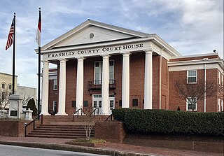
Franklin County is a county located in the U.S. state of North Carolina. As of the 2020 census, the population was 68,573. Its county seat is Louisburg.

<span class="mw-page-title-main">Edgecombe County, North Carolina</span> County in North Carolina, United States

Edgecombe County is a county located in the U.S. state of North Carolina. As of the 2020 census, the population was 48,900. Its county seat is Tarboro.

<span class="mw-page-title-main">Davie County, North Carolina</span> County in North Carolina, United States

Davie County is a county located in the U.S. state of North Carolina. As of the 2020 census, the population was 42,712. Its county seat is Mocksville.

<span class="mw-page-title-main">Caldwell County, North Carolina</span> County in North Carolina, United States

Caldwell County is a county in the U.S. state of North Carolina. It is located in the foothills of the Blue Ridge Mountains. As of the 2020 census, the population was 80,652. Its county seat is Lenoir. Caldwell County is part of the Hickory-Lenoir-Morganton, NC Metropolitan Statistical Area.

<span class="mw-page-title-main">Bertie County, North Carolina</span> County in North Carolina, United States

Bertie County is a county located in the northeast area of the U.S. state of North Carolina. As of the 2020 census, the population was 17,934. Its county seat is Windsor. The county was created in 1722 as Bertie Precinct and gained county status in 1739.

<span class="mw-page-title-main">Nashville, North Carolina</span> Town in North Carolina, United States

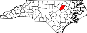
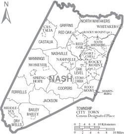
Nashville is a town in Nash County, North Carolina, United States. The town was founded in 1780 and features Victorian and Queen Anne style homes. It is part of the Rocky Mount, North Carolina Metropolitan Statistical Area. The population of Nashville was 5,632 in 2020. It is the county seat of Nash County.

<span class="mw-page-title-main">Whitakers, North Carolina</span> Town in North Carolina, United States

Whitakers is a town in Edgecombe and Nash Counties in the U.S. state of North Carolina. It is divided between the two counties by railroad tracks and is the northernmost town in the two counties. It is part of the Rocky Mount, North Carolina Metropolitan Statistical Area. The population was 744 in 2010.

<span class="mw-page-title-main">Rocky Mount metropolitan area</span> MSA in North Carolina, United States

The Rocky Mount, NC Metropolitan Statistical Area, as defined by the United States Census Bureau, is an area consisting of two counties – Edgecombe and Nash – in eastern North Carolina, anchored by the city of Rocky Mount. As of the 2010 census, the MSA had a population of 152,392. It is commonly referred to as the Twin Counties.

<span class="mw-page-title-main">Rocky Mount-Wilson-Roanoke Rapids combined statistical area</span> CSA in North Carolina, United States

The Rocky Mount-Wilson-Roanoke Rapids Combined Statistical Area, as defined by the United States Census Bureau, is an area consisting of five counties in northeastern North Carolina. As of the 2010 census, the CSA had a population of 310,416, with an estimated population of 297,726 in 2018. The statistical area includes the Rocky Mount Metropolitan Statistical Area, Wilson Micropolitan Statistical Area, and Roanoke Rapids Micropolitan Statistical Area, and the counties of Nash, Wilson, Edgecombe, Halifax, Northampton.

References

  1. 1 2 3 "QuickFacts: Nash County, North Carolina". United States Census Bureau. Retrieved March 21, 2024.
  2. "Find a County". National Association of Counties. Retrieved June 7, 2011.
  3. "2020 County Gazetteer Files – North Carolina". United States Census Bureau. August 23, 2022. Retrieved September 9, 2023.
  4. 1 2 "NCWRC Game Lands". www.ncpaws.org. Retrieved March 30, 2023.
  5. "U.S. Decennial Census". United States Census Bureau. Retrieved January 18, 2015.
  6. "Historical Census Browser". University of Virginia Library. Retrieved January 18, 2015.
  7. Forstall, Richard L., ed. (March 27, 1995). "Population of Counties by Decennial Census: 1900 to 1990". United States Census Bureau. Retrieved January 18, 2015.
  8. "Census 2000 PHC-T-4. Ranking Tables for Counties: 1990 and 2000" (PDF). United States Census Bureau. April 2, 2001. Archived (PDF) from the original on March 27, 2010. Retrieved January 18, 2015.
  9. "State & County QuickFacts". United States Census Bureau. Retrieved October 27, 2013.[ permanent dead link ]
  10. "Explore Census Data". data.census.gov. Retrieved December 24, 2021.
  11. "U.S. Census website". United States Census Bureau . Retrieved January 31, 2008.
  12. "Dave Leip's Atlas of U.S. Presidential Elections". uselectionatlas.org. Retrieved December 22, 2022.
  13. "Anatomy of a swing state: What these 6 counties tell us about the upcoming NC election". The Charlotte Observer. November 4, 2022. Retrieved November 4, 2022.
  14. Leip, David. "Dave Leip's Atlas of U.S. Presidential Elections". uselectionatlas.org. Retrieved March 16, 2018.