List of counties in North Carolina

Last updated

Counties of North Carolina
Location State of North Carolina
Number100
Populations3,461 (Tyrrell) – 1,190,275 (Wake)
Areas221 square miles (570 km2) (Clay) – 1,542 square miles (3,990 km2) (Dare)
Government
Subdivisions
Map showing the population density of North Carolina North Carolina population map.png
Map showing the population density of North Carolina

The U.S. state of North Carolina is divided into 100 counties. North Carolina ranks 28th in size by area, but has the seventh-highest number of counties in the country. [1]

Contents

Following the restoration of the monarchy in 1660, King Charles II rewarded eight persons on March 24, 1663, for their faithful support of his efforts to regain the throne of England. He gave the eight grantees, called Lords Proprietor, the land called Carolina, in honor of King Charles I, his father. The Province of Carolina, from 1663 to 1729, was a North American English (1663–1707), then British (from 1707 union with Scotland) colony. In 1729, the Province of North Carolina became a separate entity from the Province of South Carolina. [2]

The establishment of North Carolina counties stretches over 240 years, beginning in 1668 with the creation of Albemarle County and ending with the 1911 creation of Avery and Hoke counties. Five counties have been divided or abolished altogether, the last being Dobbs County in 1791.

The Federal Information Processing Standard (FIPS), [3] which is used by the United States government to uniquely identify states and counties, is provided with each entry. North Carolina's FIPS code is 37, which when combined with the county code is written as 37XXX. [4]

List

CountyFIPS code [3] County seat [5] Est. [5] Origin [6] Etymology [6] Pop.
(2023) [7]
Area [8] Map
AlamanceCounty 001 Graham 1849Orange CountyThe Battle of Alamance which was derived from the local Indian word meaning "blue clay" found in the Great Alamance Creek 179,165434 sq mi
(1,124 km2)
Map of North Carolina highlighting Alamance County.svg
AlexanderCounty 003 Taylorsville 1847Caldwell County, Iredell County, and Wilkes CountyWilliam J. Alexander, member of the legislature and Speaker of the North Carolina House of Commons 36,473264 sq mi
(684 km2)
Map of North Carolina highlighting Alexander County.svg
AlleghanyCounty 005 Sparta 1859Ashe CountyDerived from a corruption of the Delaware Indian name for the Allegheny and Ohio Rivers and is said to have meant "a fine stream"11,342236 sq mi
(611 km2)
Map of North Carolina highlighting Alleghany County.svg
AnsonCounty 007 Wadesboro 1750Bladen County George, Lord Anson (1697–1762), a celebrated English admiral who circumnavigated the globe 21,897537 sq mi
(1,391 km2)
Map of North Carolina highlighting Anson County.svg
AsheCounty 009 Jefferson 1799Wilkes County Samuel Ashe (1725–1813), a Revolutionary patriot, superior court judge and governor of North Carolina 27,063429 sq mi
(1,111 km2)
Map of North Carolina highlighting Ashe County.svg
AveryCounty 011 Newland 1911Caldwell County, Mitchell County, and Watauga County Waightstill Avery (1741–1821), a soldier of the Revolution and Attorney General of North Carolina 17,561248 sq mi
(642 km2)
Map of North Carolina highlighting Avery County.svg
BeaufortCounty 013 Washington 1712 Bath County Henry Somerset, 2nd Duke of Beaufort, who in 1709 became one of the Lords Proprietor 44,481963 sq mi
(2,494 km2)
Map of North Carolina highlighting Beaufort County.svg
BertieCounty 015 Windsor 1722Chowan CountyJames or Henry Bertie, two Lords Proprietor of colonial North Carolina 16,922741 sq mi
(1,919 km2)
Map of North Carolina highlighting Bertie County.svg
BladenCounty 017 Elizabethtown 1734New Hanover CountyMartin Bladen, a member of the Board of Trade 29,484888 sq mi
(2,300 km2)
Map of North Carolina highlighting Bladen County.svg
BrunswickCounty 019 Bolivia 1764Bladen County and New Hanover County George I of Great Britain (1660–1727), Duke of Brunswick and Lüneburg 159,9641,050 sq mi
(2,719 km2)
Map of North Carolina highlighting Brunswick County.svg
BuncombeCounty 021 Asheville 1791Burke County and Rutherford CountyEdward Buncombe, a Revolutionary soldier, who was wounded and captured at the Battle of Germantown, and died a paroled prisoner in Philadelphia 275,901660 sq mi
(1,709 km2)
Map of North Carolina highlighting Buncombe County.svg
BurkeCounty 023 Morganton 1777Rowan County Thomas Burke (1747–1783), a member of the Continental Congress and governor of North Carolina 88,338514 sq mi
(1,331 km2)
Map of North Carolina highlighting Burke County.svg
CabarrusCounty 025 Concord 1792Mecklenburg County Stephen Cabarrus (1754–1808), member of the legislature and Speaker of the North Carolina House of Commons 240,016364 sq mi
(943 km2)
Map of North Carolina highlighting Cabarrus County.svg
CaldwellCounty 027 Lenoir 1841Burke County and Wilkes County Joseph Caldwell (1773–1835), the first president of the University of North Carolina 80,574475 sq mi
(1,230 km2)
Map of North Carolina highlighting Caldwell County.svg
CamdenCounty 029 Camden 1777Pasquotank County Charles Pratt, 1st Earl Camden (1714–1794), who opposed the taxation of the American colonists 11,137310 sq mi
(803 km2)
Map of North Carolina highlighting Camden County.svg
CarteretCounty 031 Beaufort 1722Craven County John Carteret, 2nd Earl Granville (1690–1763), who inherited one-eighth share in the Province of Carolina through his great-grandfather George Carteret 69,6151,330 sq mi
(3,445 km2)
Map of North Carolina highlighting Carteret County.svg
CaswellCounty 033 Yanceyville 1777Orange County Richard Caswell (1729–1789), member of the first Continental Congress and first governor of North Carolina after the Declaration of Independence 22,807429 sq mi
(1,111 km2)
Map of North Carolina highlighting Caswell County.svg
CatawbaCounty 035 Newton 1842Lincoln County Catawba Indians164,645416 sq mi
(1,077 km2)
Map of North Carolina highlighting Catawba County.svg
ChathamCounty 037 Pittsboro 1771Orange County William Pitt, 1st Earl of Chatham (1708–1778), Secretary of State during the French and Indian War and was later Prime Minister of Great Britain 81,624709 sq mi
(1,836 km2)
Map of North Carolina highlighting Chatham County.svg
CherokeeCounty 039 Murphy 1839Macon County Cherokee Indians29,959467 sq mi
(1,210 km2)
Map of North Carolina highlighting Cherokee County.svg
ChowanCounty 041 Edenton 1668 Albemarle County Chowan Indian tribe13,891234 sq mi
(606 km2)
Map of North Carolina highlighting Chowan County.svg
ClayCounty 043 Hayesville 1861Cherokee County Henry Clay (1777–1852), statesman and orator who represented Kentucky in both the House of Representatives and Senate 11,864221 sq mi
(572 km2)
Map of North Carolina highlighting Clay County.svg
ClevelandCounty 045 Shelby 1841Lincoln County and Rutherford County Benjamin Cleveland (1738–1806), a colonel in the American Revolutionary War who took part in the Battle of Kings Mountain 101,378468 sq mi
(1,212 km2)
Map of North Carolina highlighting Cleveland County.svg
ColumbusCounty 047 Whiteville 1808Bladen County and Brunswick County Christopher Columbus (1451–1507), navigator, explorer, and one of the first Europeans to explore the Americas50,121955 sq mi
(2,473 km2)
Map of North Carolina highlighting Columbus County.svg
CravenCounty 049 New Bern 1705 Bath County William, Earl of Craven (1608–1697), who was a Lords Proprietor of colonial North Carolina 102,391773 sq mi
(2,002 km2)
Map of North Carolina highlighting Craven County.svg
CumberlandCounty 051 Fayetteville 1754Bladen County Prince William, Duke of Cumberland (1721–1765), a military leader and son of George II 337,890658 sq mi
(1,704 km2)
Map of North Carolina highlighting Cumberland County.svg
CurrituckCounty 053 Currituck 1668 Albemarle County Traditionally said to be an Indian word for wild geese, also rendered "Coratank"31,593526 sq mi
(1,362 km2)
Map of North Carolina highlighting Currituck County.svg
DareCounty 055 Manteo 1870Currituck County, Hyde County, and Tyrrell County Virginia Dare (b. 1587), the first child born of English parents in America 38,1101,542 sq mi
(3,994 km2)
Map of North Carolina highlighting Dare County.svg
DavidsonCounty 057 Lexington 1822Rowan County William Lee Davidson (1746–1781), an American Revolutionary War general who was mortally wounded at Cowan's Ford 174,804568 sq mi
(1,471 km2)
Map of North Carolina highlighting Davidson County.svg
DavieCounty 059 Mocksville 1836Rowan County William Richardson Davie (1756–1820), a member of the Federal Convention and governor of North Carolina 44,599266 sq mi
(689 km2)
Map of North Carolina highlighting Davie County.svg
DuplinCounty 061 Kenansville 1750New Hanover County Thomas Hay, Viscount Dupplin (1710–1787), who was the 9th Earl of Kinnoull 49,520820 sq mi
(2,124 km2)
Map of North Carolina highlighting Duplin County.svg
DurhamCounty 063 Durham 1881Orange County and Wake CountyThe city of Durham, which was named in honor of Dr. Bartlett Snipes Durham, who donated the land on which the earliest parts of the city were built336,892298 sq mi
(772 km2)
Map of North Carolina highlighting Durham County.svg
EdgecombeCounty 065 Tarboro 1741Bertie County Richard Edgcumbe, 1st Baron Edgcumbe (1680–1758), a Lord High Treasurer and Paymaster General for Ireland48,832507 sq mi
(1,313 km2)
Map of North Carolina highlighting Edgecombe County.svg
ForsythCounty 067 Winston-Salem 1849Stokes County Benjamin Forsyth (d. 1814), an American officer during the War of 1812 392,921412 sq mi
(1,067 km2)
Map of North Carolina highlighting Forsyth County.svg
FranklinCounty 069 Louisburg 1779 Bute County Benjamin Franklin (1706–1790), an author, politician, statesman, and Founding Father of the United States77,001494 sq mi
(1,279 km2)
Map of North Carolina highlighting Franklin County.svg
GastonCounty 071 Gastonia 1846Lincoln County William Gaston (1778–1844), a United States Congressman and justice of the North Carolina Supreme Court 237,242364 sq mi
(943 km2)
Map of North Carolina highlighting Gaston County.svg
GatesCounty 073 Gatesville 1779Chowan County, Hertford County, and Perquimans County Horatio Gates (1727–1806), an American general during the Revolution at the Battle of Saratoga 10,343346 sq mi
(896 km2)
Map of North Carolina highlighting Gates County.svg
GrahamCounty 075 Robbinsville 1872Cherokee County William Alexander Graham (1804–1875), a United States Senator, governor of North Carolina, and United States Secretary of the Navy 8,052302 sq mi
(782 km2)
Map of North Carolina highlighting Graham County.svg
GranvilleCounty 077 Oxford 1746Edgecombe County John Carteret, 2nd Earl Granville (1690–1763), who inherited one-eighth share in the Province of Carolina through his great-grandfather George Carteret 62,192538 sq mi
(1,393 km2)
Map of North Carolina highlighting Granville County.svg
GreeneCounty 079 Snow Hill 1799 Dobbs County
Originally named Glasgow County
Nathanael Greene (1742–1786), a major general of the Continental Army in the American Revolutionary War 20,530267 sq mi
(692 km2)
Map of North Carolina highlighting Greene County.svg
GuilfordCounty 081 Greensboro 1771Orange County and Rowan County Francis North, 1st Earl of Guilford (1704–1790), a British politician and father of Prime Minister of Great Britain Frederick North 549,866658 sq mi
(1,704 km2)
Map of North Carolina highlighting Guilford County.svg
HalifaxCounty 083 Halifax 1758Edgecombe County George Montagu-Dunk, 2nd Earl of Halifax (1716–1771), a British statesman and President of the Board of Trade 47,298730 sq mi
(1,891 km2)
Map of North Carolina highlighting Halifax County.svg
HarnettCounty 085 Lillington 1855Cumberland County Cornelius Harnett (1723–1781), an American Revolutionary and delegate in the Continental Congress 141,477601 sq mi
(1,557 km2)
Map of North Carolina highlighting Harnett County.svg
HaywoodCounty 087 Waynesville 1808Buncombe County John Haywood (1754–1827), a North Carolina State Treasurer 62,969555 sq mi
(1,437 km2)
Map of North Carolina highlighting Haywood County.svg
HendersonCounty 089 Hendersonville 1838Buncombe County Leonard Henderson (1772–1833), Chief Justice of the North Carolina Supreme Court 119,230375 sq mi
(971 km2)
Map of North Carolina highlighting Henderson County.svg
HertfordCounty 091 Winton 1759Bertie County, Chowan County, and Northampton County Francis Seymour-Conway, 1st Marquess of Hertford (1718–1794), who was Lord of the Bedchamber to George II and George III 19,453360 sq mi
(932 km2)
Map of North Carolina highlighting Hertford County.svg
HokeCounty 093 Raeford 1911Cumberland County and Robeson County Robert Hoke (1837–1912), a Confederate general during the American Civil War 54,446392 sq mi
(1,015 km2)
Map of North Carolina highlighting Hoke County.svg
HydeCounty 095 Swan Quarter 1712 Bath County Edward Hyde (1667–1712), a governor of colonial North Carolina 4,6071,459 sq mi
(3,779 km2)
Map of North Carolina highlighting Hyde County.svg
IredellCounty 097 Statesville 1788Rowan County James Iredell (1751–1799), a comptroller at the port of Edenton and one of the original justices of the Supreme Court of the United States 199,710597 sq mi
(1,546 km2)
Map of North Carolina highlighting Iredell County.svg
JacksonCounty 099 Sylva 1851Haywood County and Macon County Andrew Jackson (1767–1845), the 7th President of the United States44,574495 sq mi
(1,282 km2)
Map of North Carolina highlighting Jackson County.svg
JohnstonCounty 101 Smithfield 1746Craven County Gabriel Johnston (1699–1752), a governor of colonial North Carolina 241,955796 sq mi
(2,062 km2)
Map of North Carolina highlighting Johnston County.svg
JonesCounty 103 Trenton 1779Craven County Willie Jones (1740–1801), opposed the ratification of the United States Constitution and declined an invitation to the Constitutional Convention 9,401474 sq mi
(1,228 km2)
Map of North Carolina highlighting Jones County.svg
LeeCounty 105 Sanford 1907Chatham County and Moore County Robert E. Lee (1807–1870), a career United States Army officer and general of the Confederate forces during the American Civil War 67,059259 sq mi
(671 km2)
Map of North Carolina highlighting Lee County.svg
LenoirCounty 107 Kinston 1791 Dobbs County William Lenoir (1751–1839), a captain in the American Revolutionary War who took part in the Battle of Kings Mountain 54,895401 sq mi
(1,039 km2)
Map of North Carolina highlighting Lenoir County.svg
LincolnCounty 109 Lincolnton 1779 Tryon County Benjamin Lincoln (1733–1810), a major general during the American Revolutionary War who participated in the Siege of Yorktown 95,675305 sq mi
(790 km2)
Map of North Carolina highlighting Lincoln County.svg
MaconCounty 113 Franklin 1828Haywood County Nathaniel Macon (1758–1837), a member and Speaker of the United States House of Representatives 38,412520 sq mi
(1,347 km2)
Map of North Carolina highlighting Macon County.svg
MadisonCounty 115 Marshall 1851Buncombe County and Yancey County James Madison (1751–1836), the 4th President of the United States22,071451 sq mi
(1,168 km2)
Map of North Carolina highlighting Madison County.svg
MartinCounty 117 Williamston 1774Halifax County and Tyrrell County Josiah Martin (1737–1786), the last governor of colonial North Carolina 21,447457 sq mi
(1,184 km2)
Map of North Carolina highlighting Martin County.svg
McDowellCounty 111 Marion 1842Burke County and Rutherford County Joseph McDowell (1756–1801), a soldier in the American Revolutionary War who took part in the Battle of Kings Mountain 44,893445 sq mi
(1,153 km2)
Map of North Carolina highlighting McDowell County.svg
MecklenburgCounty 119 Charlotte 1762Anson County Charlotte of Mecklenburg-Strelitz (1744–1818), the queen consort of George III of the United Kingdom 1,163,701546 sq mi
(1,414 km2)
Map of North Carolina highlighting Mecklenburg County.svg
MitchellCounty 121 Bakersville 1861Burke County, Caldwell County, McDowell County, Watauga County, and Yancey County Elisha Mitchell (1793–1857), a professor at the University of North Carolina who measured the height of Mount Mitchell 14,999222 sq mi
(575 km2)
Map of North Carolina highlighting Mitchell County.svg
MontgomeryCounty 123 Troy 1779Anson County Richard Montgomery (1738–1775), a major general during the Revolutionary War who was killed at the Battle of Quebec 26,085502 sq mi
(1,300 km2)
Map of North Carolina highlighting Montgomery County.svg
MooreCounty 125 Carthage 1784Cumberland County Alfred Moore (1755–1810), a captain in the Revolutionary War and justice of the Supreme Court of the United States 106,898706 sq mi
(1,829 km2)
Map of North Carolina highlighting Moore County.svg
NashCounty 127 Nashville 1777Edgecombe County Francis Nash (1742–1777), a brigadier general in the Revolutionary War who was mortally wounded at the Battle of Germantown 96,551543 sq mi
(1,406 km2)
Map of North Carolina highlighting Nash County.svg
New HanoverCounty 129 Wilmington 1729Craven CountyThe royal family of England, members of the House of Hanover 238,852329 sq mi
(852 km2)
Map of North Carolina highlighting New Hanover County.svg
NorthamptonCounty 131 Jackson 1741Bertie County James Compton, 5th Earl of Northampton (1687–1754), a British peer and politician16,715551 sq mi
(1,427 km2)
Map of North Carolina highlighting Northampton County.svg
OnslowCounty 133 Jacksonville 1734New Hanover County Arthur Onslow (1691–1768), Speaker of the House of Commons 213,676905 sq mi
(2,344 km2)
Map of North Carolina highlighting Onslow County.svg
OrangeCounty 135 Hillsborough 1752Bladen County, Granville County, and Johnston CountyUnknown; possibly Prince William V of Orange (1748–1806), the last Stadtholder of the Dutch Republic; or William of Orange (1650–1702), who became King of England after the Glorious Revolution [9] 150,626401 sq mi
(1,039 km2)
Map of North Carolina highlighting Orange County.svg
PamlicoCounty 137 Bayboro 1872Beaufort County and Craven County Pamlico Sound and the Pamlico Indian tribe12,423562 sq mi
(1,456 km2)
Map of North Carolina highlighting Pamlico County.svg
PasquotankCounty 139 Elizabeth City 1668 Albemarle County Derived from the Indian word "pasketanki" which meant "where the current of the stream divides or forks"41,444289 sq mi
(749 km2)
Map of North Carolina highlighting Pasquotank County.svg
PenderCounty 141 Burgaw 1875New Hanover County William Dorsey Pender (1834–1863), Confederate soldier who was mortally wounded at the Battle of Gettysburg of the American Civil War 68,521934 sq mi
(2,419 km2)
Map of North Carolina highlighting Pender County.svg
PerquimansCounty 143 Hertford 1668 Albemarle County The Indian word "perquimans" means "land of beautiful women" and was coined by a sect of the Yeopim tribe, later becoming the 'Perquiman'13,377329 sq mi
(852 km2)
Map of North Carolina highlighting Perquimans County.svg
PersonCounty 145 Roxboro 1791Caswell County Thomas Person, an American Revolutionary War patriot39,737404 sq mi
(1,046 km2)
Map of North Carolina highlighting Person County.svg
PittCounty 147 Greenville 1760Beaufort County William Pitt, 1st Earl of Chatham (1708–1778), Secretary of State during the French and Indian War and was later Prime Minister of Great Britain 175,119656 sq mi
(1,699 km2)
Map of North Carolina highlighting Pitt County.svg
PolkCounty 149 Columbus 1855Henderson County and Rutherford County William Polk (1758–1834), officer in the American Revolutionary War and first president of the State Bank of North Carolina20,060238 sq mi
(616 km2)
Map of North Carolina highlighting Polk County.svg
RandolphCounty 151 Asheboro 1779Guilford County Peyton Randolph (c.1721–1755), the first President of the Continental Congress 147,458790 sq mi
(2,046 km2)
Map of North Carolina highlighting Randolph County.svg
RichmondCounty 153 Rockingham 1779Anson County Charles Lennox, 3rd Duke of Richmond (1735–1806), a firm supporter of the American colonists and advocated removal of British troops42,324480 sq mi
(1,243 km2)
Map of North Carolina highlighting Richmond County.svg
RobesonCounty 155 Lumberton 1787Bladen CountyThomas Robeson, an officer in the American Revolutionary War 117,365949 sq mi
(2,458 km2)
Map of North Carolina highlighting Robeson County.svg
RockinghamCounty 157 Wentworth 1785Guilford County Charles Watson-Wentworth, 2nd Marquess of Rockingham (1730–1782), a British statesmen and two-time Prime Minister of Great Britain 92,518573 sq mi
(1,484 km2)
Map of North Carolina highlighting Rockingham County.svg
RowanCounty 159 Salisbury 1753Anson County Matthew Rowan (d. 1769), was the acting Governor of colonial North Carolina following the death of Governor Nathaniel Rice 151,661524 sq mi
(1,357 km2)
Map of North Carolina highlighting Rowan County.svg
RutherfordCounty 161 Rutherfordton 1779 Tryon County Griffith Rutherford (c.1721–1805), an officer in the American Revolutionary War and a political leader in North Carolina 65,507567 sq mi
(1,469 km2)
Map of North Carolina highlighting Rutherford County.svg
SampsonCounty 163 Clinton 1784Duplin County John Sampson, a member of Josiah Martin's council59,601948 sq mi
(2,455 km2)
Map of North Carolina highlighting Sampson County.svg
ScotlandCounty 165 Laurinburg 1899Richmond CountyThe country Scotland, part of the United Kingdom34,376321 sq mi
(831 km2)
Map of North Carolina highlighting Scotland County.svg
StanlyCounty 167 Albemarle 1841Montgomery County John Stanly (1774–1834), a United States Congressman and Speaker of the North Carolina House of Commons 65,699405 sq mi
(1,049 km2)
Map of North Carolina highlighting Stanly County.svg
StokesCounty 169 Danbury 1789Surry County John Stokes, a soldier of the Revolution who was seriously wounded at the Waxhaw massacre 45,532456 sq mi
(1,181 km2)
Map of North Carolina highlighting Stokes County.svg
SurryCounty 171 Dobson 1771Rowan CountyThe county of Surrey in England, birthplace of then governor William Tryon 71,462537 sq mi
(1,391 km2)
Map of North Carolina highlighting Surry County.svg
SwainCounty 173 Bryson City 1871Jackson County and Macon County David Lowry Swain (1801–1868), a governor of North Carolina and president of the University of North Carolina 13,916540 sq mi
(1,399 km2)
Map of North Carolina highlighting Swain County.svg
TransylvaniaCounty 175 Brevard 1861Henderson County and Jackson CountyDerived from the Latin words, trans meaning "across" and sylva meaning "woods"33,549380 sq mi
(984 km2)
Map of North Carolina highlighting Transylvania County.svg
TyrrellCounty 177 Columbia 1729Chowan County, Currituck County, and Pasquotank County John Tyrrell, at one time was a Lords Proprietor 3,461597 sq mi
(1,546 km2)
Map of North Carolina highlighting Tyrrell County.svg
UnionCounty 179 Monroe 1842Anson County and Mecklenburg CountyCreated as a compromise after a dispute between local Whigs and Democrats as to whether it should be named Clay or Jackson county256,452640 sq mi
(1,658 km2)
Map of North Carolina highlighting Union County.svg
VanceCounty 181 Henderson 1881Franklin County, Granville County, and Warren County Zebulon Baird Vance (1830–1894), a Confederate military officer in the American Civil War, twice governor of North Carolina, and United States Senator 42,301269 sq mi
(697 km2)
Map of North Carolina highlighting Vance County.svg
WakeCounty 183 Raleigh 1771Cumberland County, Johnston County, and Orange CountyMargaret Wake, the wife of British colonial governor William Tryon 1,190,275857 sq mi
(2,220 km2)
Map of North Carolina highlighting Wake County.svg
WarrenCounty 185 Warrenton 1779 Bute County Joseph Warren (1741–1775), a Patriot and volunteer private who was mortally wounded at the Battle of Bunker Hill 18,836444 sq mi
(1,150 km2)
Map of North Carolina highlighting Warren County.svg
WashingtonCounty 187 Plymouth 1799Tyrrell County George Washington (1732–1799), the 1st president of the United States10,713422 sq mi
(1,093 km2)
Map of North Carolina highlighting Washington County.svg
WataugaCounty 189 Boone 1849Ashe County, Caldwell County, Wilkes County, and Yancey CountyThe Watauga River, which came from an Indian word meaning "beautiful water"54,748313 sq mi
(811 km2)
Map of North Carolina highlighting Watauga County.svg
WayneCounty 191 Goldsboro 1779 Dobbs County Anthony Wayne (1745–1796), a general in the American Revolutionary War 118,686558 sq mi
(1,445 km2)
Map of North Carolina highlighting Wayne County.svg
WilkesCounty 193 Wilkesboro 1777Surry County John Wilkes (1725–1797), an English radical, journalist, and politician66,013756 sq mi
(1,958 km2)
Map of North Carolina highlighting Wilkes County.svg
WilsonCounty 195 Wilson 1855Edgecombe County, Johnston County, Nash County, and Wayne County Louis D. Wilson, a state legislator from Edgecombe County who died of fever at Veracruz during the Mexican–American War 78,970373 sq mi
(966 km2)
Map of North Carolina highlighting Wilson County.svg
YadkinCounty 197 Yadkinville 1850Surry CountyThe Yadkin River 37,774338 sq mi
(875 km2)
Map of North Carolina highlighting Yadkin County.svg
YanceyCounty 199 Burnsville 1833Buncombe County and Burke County Bartlett Yancey (1785–1828), a United States Congressman, Speaker of the North Carolina Senate, and early advocate for the North Carolina Public School System18,938313 sq mi
(811 km2)
Map of North Carolina highlighting Yancey County.svg

Historic counties

CountyCreatedAbolishedFate
Albemarle County 1664 [10] 1738 [10] Partitioned into Chowan County, Currituck County, Pasquotank County, and Perquimans County
Bath County 1696 [11] 1738 [11] Partitioned into Beaufort County, Craven County, and Hyde County
Bute County 1764 [12] 1779 [12] Partitioned into Franklin County and Warren County
Dobbs County 1758 [13] 1791 [13] Partitioned into Greene County, Lenoir County, and Wayne County
Tryon County 1768 [14] 1779 [14] Partitioned into Lincoln County and Rutherford County

For several months in 1784, Cumberland County was known as Fayette County and sent representatives to the North Carolina General Assembly of April 1784 under this name. [15]

Proposed counties

In the state's history, two counties have officially been proposed, but not created—Hooper County and Lillington County, in 1851 and 1859, respectively. The former was to be created from parts of Richmond and Robeson Counties, and the latter was to be created from parts of New Hanover County. Both of the proposals failed in their respective referenda. Later on, Scotland County would be created in the area where Hooper County was proposed, and Pender County would fill the area where Lillington County was proposed. [16] [17]

See also

Related Research Articles

<span class="mw-page-title-main">North Carolina</span> U.S. state

North Carolina is a state in the Southeastern region of the United States. It is bordered by Virginia to the north, the Atlantic Ocean to the east, South Carolina to the south, Georgia to the southwest, and Tennessee to the west. The state is the 28th-largest and 9th-most populous of the United States. Along with South Carolina, it makes up the Carolinas region of the East Coast. At the 2020 census, the state had a population of 10,439,388. Raleigh is the state's capital and Charlotte is its most populous city. The Charlotte metropolitan area, with an estimated population of 2,805,115 in 2023, is the most populous metropolitan area in North Carolina, the 22nd-most populous in the United States, and the largest banking center in the nation after New York City. The Research Triangle, with an estimated population of 2,368,947 in 2023, is the second-most populous combined metropolitan area in the state, 31st-most populous in the United States, and is home to the largest research park in the United States, Research Triangle Park.

<span class="mw-page-title-main">Tyrrell County, North Carolina</span> County in North Carolina, United States

Tyrrell County is a county located in the U.S. state of North Carolina. As of the 2020 census, the population was 3,245, making it the least populous county in North Carolina. Its county seat is Columbia. The county was created in 1729 as Tyrrell Precinct and gained county status in 1739.

<span class="mw-page-title-main">Harnett County, North Carolina</span> County in North Carolina, United States

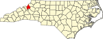
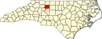
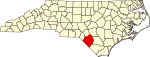
Harnett County is a county located in the U.S. state of North Carolina. As of the 2020 census, the population was 133,568. Its county seat is Lillington; its largest community is Anderson Creek. Harnett County is part of the Anderson Creek, NC Micropolitan Statistical Area.

<span class="mw-page-title-main">Dare County, North Carolina</span> County in North Carolina, United States

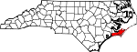
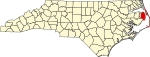
Dare County is the easternmost county in the U.S. state of North Carolina. As of the 2020 census, the population was 36,915. Its county seat is Manteo.

<span class="mw-page-title-main">Currituck County, North Carolina</span> County in North Carolina, United States

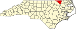
Currituck County is the northeasternmost county in the U.S. state of North Carolina. As of the 2020 census, the population was 28,100. Its county seat is Currituck. The county was formed in 1668 as a precinct of Albemarle County and later gained county status in 1739. The name is "traditionally said to be an indigenous word for wild geese; Coratank." Currituck County is included in the Virginia Beach-Chesapeake, VA-NC Combined Statistical Area. It is in the northeastern section of the state and is bounded by the Atlantic Ocean, Currituck Sound, Camden County, Dare County and the Commonwealth of Virginia. Currituck Court House, mentioned as early as 1755, was the name of the county seat. Today the words "Court House" have been dropped and only Currituck is used as the community name.

<span class="mw-page-title-main">Craven County, North Carolina</span> County in North Carolina, United States

Craven County is located in the U.S. state of North Carolina. As of the 2020 census, the population was 100,720. Its county seat is New Bern. The county was created in 1705 as Archdale Precinct from the now-extinct Bath County. It was renamed Craven Precinct in 1712 and gained county status in 1739. It is named for William, Earl of Craven, who lived from 1606 to 1697. Craven County is part of the New Bern, NC Micropolitan Statistical Area.

<span class="mw-page-title-main">Chowan County, North Carolina</span> County in North Carolina, United States

Chowan County is one of the 100 counties located in the U.S. state of North Carolina. As of the 2020 census, the population was 13,708. Its county seat is Edenton. The county was created between 1668 and 1671 as Shaftesbury Precinct and later renamed Chowan Precinct. It gained county status in 1739.

<span class="mw-page-title-main">Lillington, North Carolina</span> Town in North Carolina, United States

Lillington is a town and county seat of Harnett County, North Carolina, United States. Its population was 3,194 at the 2010 census, and was 4,735 in the 2020 census. Lillington is a part of the Dunn micropolitan area, which is also a part of the greater Raleigh–Durham–Cary combined statistical area as defined by the United States Census Bureau.

<span class="mw-page-title-main">Statesville, North Carolina</span> City in North Carolina, United States

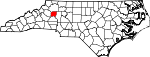
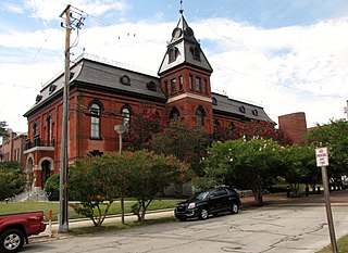
Statesville is a city in and the county seat of Iredell County, North Carolina, United States, and it is part of the Charlotte metropolitan area. Statesville was established in 1789 by an act of the North Carolina Legislature. The population was 28,419 at the time of the 2020 census.

<span class="mw-page-title-main">Carolinas</span> U.S. states of North Carolina and South Carolina

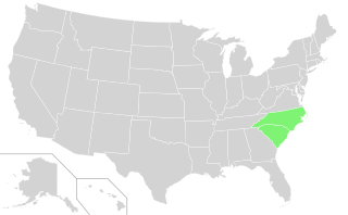
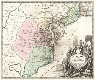
The Carolinas are the U.S. states of North Carolina and South Carolina, considered collectively. They are bordered by Virginia to the north, Tennessee to the west, and Georgia to the southwest. The Atlantic Ocean is to the east.

<span class="mw-page-title-main">Dobbs County, North Carolina</span> Historic county of North Carolina

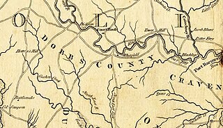
Dobbs County, North Carolina was a county located in the U.S. state of North Carolina.

<span class="mw-page-title-main">Province of North Carolina</span> Former British province in North America

The Province of North Carolina, originally known as Albemarle Province, was a proprietary colony and later royal colony of Great Britain that existed in North America from 1712 to 1776.(p. 80) It was one of the five Southern colonies and one of the thirteen American colonies. The monarch of Great Britain was represented by the Governor of North Carolina, until the colonies declared independence on July 4, 1776.

<span class="mw-page-title-main">Province of Carolina</span> English (later British) colony in North America and the Caribbean (1663–1712)

The Province of Carolina was a province of the Kingdom of England (1663–1707) and later the Kingdom of Great Britain (1707–1712) that existed in North America and the Caribbean from 1663 until the Carolinas were partitioned into North and South on January 24, 1712.

<span class="mw-page-title-main">Albemarle Sound</span> An estuary on the coast of North Carolina, United States

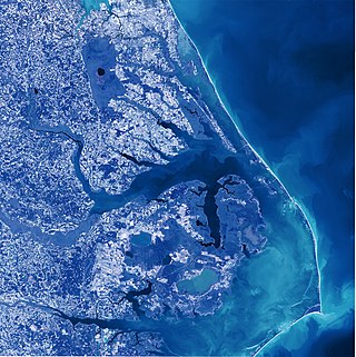
Albemarle Sound is a large estuary on the coast of North Carolina in the United States located at the confluence of a group of rivers, including the Chowan and Roanoke. It is separated from the Atlantic Ocean by the Currituck Banks, a barrier peninsula upon which the town of Kitty Hawk is located, at the eastern edge of the sound, and part of the greater Outer Banks region. Roanoke Island is situated at the southeastern corner of the sound, where it connects to Pamlico Sound. Much of the water in the Albemarle Sound is brackish or fresh, as opposed to the saltwater of the ocean, as a result of river water pouring into the sound.

<span class="mw-page-title-main">Outer Banks</span> Barrier islands in North Carolina, United States

The Outer Banks are a 200 mi (320 km) string of barrier islands and spits off the coast of North Carolina and southeastern Virginia, on the east coast of the United States. They line most of the North Carolina coastline, separating Currituck Sound, Albemarle Sound, and Pamlico Sound from the Atlantic Ocean. A major tourist destination, the Outer Banks are known for their wide expanse of open beachfront and the Cape Hatteras National Seashore. The seashore and surrounding ecosystem are important biodiversity zones, including beach grasses and shrubland that help maintain the form of the land.

<span class="mw-page-title-main">Albemarle County, North Carolina</span> Historic county of North Carolina

Albemarle County, North Carolina was a county located in the Province of North Carolina. It contained what is now the northeastern portion of the U.S. state of North Carolina.

<span class="mw-page-title-main">Bath County, North Carolina</span> Historic county of North Carolina

Bath County is an extinct county formerly located in the British American colony of North Carolina. The county was established in 1696 and was abolished in 1739. The original three precincts of Bath County—Pamtecough, Wyckham and Archdale—were renamed in 1712 to Beaufort, Hyde, and Craven Precincts, respectively. These original precincts—along with the four other precincts of the county —became Beaufort, Hyde, Craven, Bladen, Onslow, Carteret, and New Hanover counties when Bath County was officially abolished in 1738.

Kipling is an unincorporated community located along U.S. Route 401 in the Hectors Creek Township of Harnett County, North Carolina, United States, situated between the communities of Cape Fear and Chalybeate Springs north of Lillington. It is a part of the Dunn Micropolitan Area, which is also a part of the greater Raleigh–Durham–Cary Combined Statistical Area (CSA) as defined by the United States Census Bureau.

References

  1. "How Many Counties are in Your State?". Click and Learn. Archived from the original on April 22, 2009. Retrieved August 26, 2009.
  2. "LEARN NC has been archived". www.learnnc.org. Archived from the original on January 27, 2018. Retrieved April 28, 2018.
  3. 1 2 "EPA County FIPS Code Listing". US Environmental Protection Agency. Archived from the original on September 28, 2004. Retrieved February 6, 2008.
  4. "North Carolina County FIPS Codes". www.lib.ncsu.edu. Retrieved November 7, 2022.
  5. 1 2 "NACo – Find a county". National Association of Counties. Archived from the original on December 11, 2011. Retrieved August 31, 2011.
  6. 1 2 "County Histories". The State Library of North Carolina. Archived from the original on August 25, 2011. Retrieved August 31, 2011.
  7. "QuickFacts: North Carolina". United States Census Bureau. Retrieved April 20, 2024.
  8. "2020 County Gazetteer Files – North Carolina". United States Census Bureau. August 23, 2022. Retrieved September 10, 2023.
  9. "Orange County". NCpedia. Retrieved March 17, 2024.
  10. 1 2 "Historic Albemarle County North Carolina Genealogy". USGenNet. Archived from the original on October 7, 2008. Retrieved July 24, 2008.
  11. 1 2 "Historic Bath County North Carolina Genealogy". USGenNet. Archived from the original on June 24, 2008. Retrieved July 24, 2008.
  12. 1 2 "Bute Co., North Carolina GenWeb 1764–1779". RootsWeb. Archived from the original on May 22, 2008. Retrieved July 24, 2008.
  13. 1 2 "Dobbs County, NC GenWeb Archives". USGenWeb. Archived from the original on July 23, 2008. Retrieved July 24, 2008.
  14. 1 2 "Finding Tryon County Ancestors". Gaston-Lincoln Regional Library System. Archived from the original on October 1, 2011. Retrieved August 31, 2011.
  15. Cheney, John L. Jr., ed. (1974). North Carolina Government, 1585–1974. pp.  212-213.
  16. "1851 North Carolina Legislative Act to Establish Hooper County". www.carolana.com. Retrieved April 24, 2024.
  17. "North Carolina Gazetteer browse". NCpedia. Retrieved April 24, 2024.

Works cited