Brevard, North Carolina

Last updated

Brevard, North Carolina
Brevard, North Carolina - Transylvania Co. Courthouse (cropped).JPG
Brevard, NC City Seal.png
NCMap-doton-Brevard.PNG
Location of Brevard, North Carolina
Coordinates: 35°14′38″N82°43′35″W / 35.24389°N 82.72639°W / 35.24389; -82.72639
CountryUnited States
State North Carolina
County Transylvania
Founded1861 [1]
Incorporated1889 [1]
Named for Ephraim Brevard [1]
Government
  MayorMaureen Copelof
Area
[2]
  Total5.36 sq mi (13.88 km2)
  Land5.36 sq mi (13.87 km2)
  Water0.00 sq mi (0.01 km2)
Elevation
[3]
2,149 ft (655 m)
Population
 (2020)
  Total7,744
  Density1,445.59/sq mi (558.15/km2)
Time zone UTC−5 (Eastern (EST))
  Summer (DST) UTC−4 (EDT)
ZIP code
28712
Area code 828
FIPS code 37-07720 [4]
GNIS feature ID2403920 [3]
Website www.cityofbrevard.com

Brevard is a city and the county seat of Transylvania County, North Carolina, United States, with a population of 7,609 as of the 2010 census. [5]

Contents

Brevard is located at the entrance to Pisgah National Forest and has become a noted tourism, retirement and cultural center in western North Carolina. A moderate climate, environmental beauty and cultural activities attracts retirees to the area.

Brevard is also known for its white squirrels. There are several theories of how they came to live there, including an overturned carnival truck and an escaped pet breeding with native squirrels. [6]

Along with nearby Asheville and Hendersonville, Brevard forms the Asheville-Brevard, NC CSA combined statistical area.

History

According to the Transylvania Heritage Museum, the North Carolina General Assembly apportioned Transylvania County on February 15, 1861, from lands previously attributed to neighboring Jackson and Henderson counties. In the county's creation, a county seat was required to be conveniently accessible to most of the county's citizens. Its namesake was to honor Colonel Ephraim Brevard, M.D., a reputed Revolutionary War veteran. [7]

Geography

According to the United States Census Bureau, the city has a total area of 5.12 square miles, [8] of which 0% is water.

Climate

Brevard is located in a temperate rainforest and has a climate that borders between a humid subtropical and oceanic climate and receives abundant rainfall year round due to orographic lift due to its location in the Blue Ridge Mountains and the nearby Great Balsam Mountains. [9] It is one of the wettest towns in the US outside of the Pacific Northwest. It is also common for the town to get small amounts of snow in the winter. The town does not have any dry season, but fall gets the least amount of rain of all the seasons.

Climate data for Brevard, North Carolina (1991–2020 normals, extremes 1902–present)
MonthJanFebMarAprMayJunJulAugSepOctNovDecYear
Record high °F (°C)85
(29)
79
(26)
89
(32)
90
(32)
96
(36)
98
(37)
99
(37)
99
(37)
97
(36)
92
(33)
82
(28)
79
(26)
99
(37)
Mean daily maximum °F (°C)48.8
(9.3)
52.6
(11.4)
59.7
(15.4)
69.0
(20.6)
75.1
(23.9)
80.6
(27.0)
82.8
(28.2)
81.7
(27.6)
76.7
(24.8)
69.2
(20.7)
59.1
(15.1)
51.0
(10.6)
67.2
(19.6)
Daily mean °F (°C)37.0
(2.8)
39.9
(4.4)
46.5
(8.1)
55.0
(12.8)
62.5
(16.9)
69.5
(20.8)
72.5
(22.5)
71.7
(22.1)
66.0
(18.9)
56.3
(13.5)
45.7
(7.6)
39.3
(4.1)
55.2
(12.9)
Mean daily minimum °F (°C)25.2
(−3.8)
27.3
(−2.6)
33.2
(0.7)
40.9
(4.9)
50.0
(10.0)
58.3
(14.6)
62.2
(16.8)
61.7
(16.5)
55.4
(13.0)
43.4
(6.3)
32.2
(0.1)
27.7
(−2.4)
43.1
(6.2)
Record low °F (°C)−15
(−26)
−20
(−29)
−2
(−19)
14
(−10)
25
(−4)
31
(−1)
41
(5)
33
(1)
29
(−2)
15
(−9)
2
(−17)
−12
(−24)
−20
(−29)
Average precipitation inches (mm)6.98
(177)
5.38
(137)
5.88
(149)
5.83
(148)
5.63
(143)
6.83
(173)
6.30
(160)
7.56
(192)
6.07
(154)
6.15
(156)
5.87
(149)
7.09
(180)
75.57
(1,919)
Average snowfall inches (cm)1.7
(4.3)
1.4
(3.6)
0.8
(2.0)
0.0
(0.0)
0.0
(0.0)
0.0
(0.0)
0.0
(0.0)
0.0
(0.0)
0.0
(0.0)
0.0
(0.0)
0.2
(0.51)
3.0
(7.6)
7.1
(18)
Average precipitation days (≥ 0.01 in)9.89.512.110.611.614.215.314.410.08.48.110.6134.6
Average snowy days (≥ 0.1 in)0.60.60.20.00.00.00.00.00.00.00.00.62.0
Source: NOAA [10] [11]

Demographics

Historical population
CensusPop.Note
1880 223
1890 32746.6%
1900 58478.6%
1910 91957.4%
1920 1,65880.4%
1930 2,33941.1%
1940 3,06130.9%
1950 3,90827.7%
1960 4,85724.3%
1970 5,2437.9%
1980 5,3231.5%
1990 5,3881.2%
2000 6,78926.0%
2010 7,60912.1%
2020 7,7441.8%
U.S. Decennial Census [12]
West Main Street in Brevard, circa 1886 Brevard, North Carolina (circa 1886).jpg
West Main Street in Brevard, circa 1886

2020 census

Brevard racial composition [13]
RaceNumberPercentage
White (non-Hispanic)6,14079.29%
Black or African American (non-Hispanic)6778.74%
Native American 250.32%
Asian 750.97%
Pacific Islander 150.19%
Other/Mixed 3864.98%
Hispanic or Latino 4265.5%

As of the 2020 United States census, there were 7,744 people, 3,530 households, and 2,005 families residing in the city.[ citation needed ]

2010 census

As of the census [4] of 2010, there were 7,609 people, 3,253 households, and 1,711 families residing in the city. The population density was 1,486 inhabitants per square mile (574/km2). The racial makeup of the city was 83.3% White, 11.0% African American, 0.3% Native American, 1.0% Asian, 0.07%, 0.46% from other races, and 2.7% from two or more races. Hispanic or Latino of any race were 3.7% of the population.

There were 2,826 households, out of which 21.8% had children under the age of 18 living with them, 44.2% were married couples living together, 13.3% had a female householder with no husband present, and 39.9% were non-families. 36.0% of all households were made up of individuals, and 18.9% had someone living alone who was 65 years of age or older. The average household size was 2.12, and the average family size was 2.73.

The population was distributed broadly among different age groups, with 18.3% under the age of 18, 12.3% from 18 to 24, 19.9% from 25 to 44, 21.3% from 45 to 64, and 28.2% who were 65 years of age or older. The median age was 45 years. For every 100 females, there were 79.3 males. For every 100 females age 18 and over, there were 73.4 males.

The median income for a household in the city was $33,497, and the median income for a family was $44,489. Males had a median income of $26,929 versus $21,348 for females. The per capita income for the city was $18,256. About 7.61% of families and 10.7% of the population were below the poverty line, including 17.0% of those under age 18 and 5.9% of those age 65 or over.

Arts and culture

White Squirrel Festival [14] takes place on the Friday, Saturday, and Sunday preceding Memorial Day. It features the white Squirrel, Pisgah Pete, live music, arts & crafts, and food. The white variant of the eastern gray squirrel ( Sciurus carolinensis ) is commonly seen around Brevard. [15] [16]

Independence Day is a major event in Brevard. The celebrations include an annual fireworks display and a car judging competition. Streets downtown are blocked off for a festival including games, arts and crafts, concerts and food vendors.

Halloweenfest [17] takes place on the last Saturday of October in downtown Brevard. Brevard is located in Transylvania County and it shows up in the enthusiasm seen in the costumes during the event. Live music, other street performers, arts & crafts, Flight of the Vampires 5K Run, pet costume contest, haunted house, ghost tour, and other activities happen all day.

Twilight Tour: [18] Early in the morning runners come out for the Reindeer Run 5K Run. Street vendors appear in the afternoon after downtown is closed to traffic. The Christmas Parade proceeds down South Broad Street around 3pm, starting at Brevard High School and ending at Brevard College. After the parade, Twilight Tour takes place with, horse-drawn carriages, luminaries, seasonal music, and food in the many downtown shops & restaurants.[ citation needed ]

Education

Ross Hall in Brevard College BrevardCollege.jpg
Ross Hall in Brevard College

Transylvania County Schools has two public high schools: Brevard High School and Rosman High School. The system also has an alternative high school in Davidson River School. There are four elementary schools and two middle schools. There is also one charter school, Brevard Academy, and several smaller private schools.

Brevard College, a four-year liberal arts institution, is located in Brevard.

The town is also home to the Brevard Music Center, and to a campus of the Blue Ridge Community College.

During the summer Brevard holds a distance runners camp at Brevard College.[ citation needed ]

Notable people

Sister city

Brevard has one sister city, as designated by Sister Cities International:

See also

Related Research Articles

<span class="mw-page-title-main">Watauga County, North Carolina</span> County in North Carolina, United States

Watauga County is a county located in the U.S. state of North Carolina. As of the 2020 census, the population was 54,086. Its county seat and largest community is Boone. The county is in an exceptionally mountainous region, known as the High Country. It is the home of Appalachian State University, which has approximately 20,023 students as of August 2020. Watauga County comprises the Boone, NC Micropolitan Statistical Area.

<span class="mw-page-title-main">Transylvania County, North Carolina</span> County in North Carolina, United States

Transylvania County is a county in the U.S. state of North Carolina. As of the 2020 census the population is 32,986. Its county seat is Brevard.

<span class="mw-page-title-main">Madison County, North Carolina</span> County in North Carolina, United States

Madison County is a county located in the U.S. state of North Carolina. As of the 2020 census, the population was 21,193. Its county seat is Marshall. Madison County is part of the Asheville, NC Metropolitan Statistical Area.

<span class="mw-page-title-main">Henderson County, North Carolina</span> County in North Carolina, United States

Henderson County is a county located in the U.S. state of North Carolina. As of the 2020 census, the population was 116,281. Its county seat is Hendersonville.

<span class="mw-page-title-main">Haywood County, North Carolina</span> County in North Carolina, United States

Haywood County is a county located in the U.S. state of North Carolina. As of the 2020 census, the population was 62,089. The county seat and its largest community is Waynesville.

<span class="mw-page-title-main">Forsyth County, North Carolina</span> County in North Carolina, United States

Forsyth County is located in the northwest Piedmont of the U.S. state of North Carolina. As of the 2020 census, the population was 382,590, making it the fourth-most populous county in North Carolina. Its county seat is Winston-Salem. Forsyth County is part of the Winston-Salem, NC, Metropolitan Statistical Area, which is also included in the Greensboro–Winston-Salem–High Point, NC, Combined Statistical Area. Portions of Forsyth County are in the Yadkin Valley wine region.

<span class="mw-page-title-main">Caldwell County, North Carolina</span> County in North Carolina, United States

Caldwell County is a county in the U.S. state of North Carolina. It is located in the foothills of the Blue Ridge Mountains. As of the 2020 census, the population was 80,652. Its county seat is Lenoir. Caldwell County is part of the Hickory-Lenoir-Morganton, NC Metropolitan Statistical Area.

<span class="mw-page-title-main">Burke County, North Carolina</span> County in North Carolina, United States

Burke County is a county located in the U.S. state of North Carolina. As of the 2020 census, its population was 87,570. Its county seat is Morganton.

<span class="mw-page-title-main">Buncombe County, North Carolina</span> County in North Carolina, United States

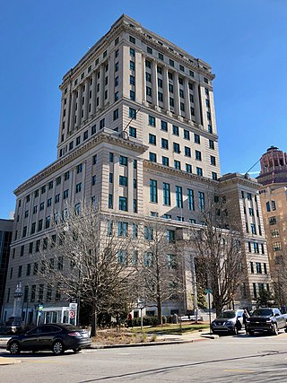
Buncombe County is a county located in the U.S. state of North Carolina. It is classified within Western North Carolina. The 2020 census reported the population was 269,452, making it the 7th-most populous county in North Carolina. Its county seat is Asheville. Buncombe County is part of the Asheville, NC Metropolitan Statistical Area.

<span class="mw-page-title-main">Beaufort County, North Carolina</span> County in North Carolina, United States

Beaufort County is a county located in the U.S. state of North Carolina. As of the 2020 census, the population was 44,652. Its county seat is Washington. The county was founded in 1705 as Pamptecough Precinct. Originally included in Bath County, it was renamed Beaufort Precinct in 1712 and became Beaufort County in 1739.

<span class="mw-page-title-main">Pisgah, Iowa</span> City in Iowa, United States

Pisgah is a city in Harrison County, Iowa, United States, along the Soldier River. The community is located in the midst of the Loess Hills. The population was 249 at the time of the 2020 census.

<span class="mw-page-title-main">Bent Creek, Buncombe County, North Carolina</span> Census-designated place in North Carolina, United States

Bent Creek is a census-designated place (CDP) in Buncombe County, North Carolina, United States. The population was 1,287 at the 2010 census. The Bent Creek area has mountain bike trails within the Pisgah National Forest.

<span class="mw-page-title-main">Mocksville, North Carolina</span> Town in North Carolina, United States

Mocksville is a town in Davie County, North Carolina, United States. The population was 5,900 at the 2020 census. I-40 leads west to Statesville and Hickory, and east to Winston-Salem and Greensboro. Route 64 heads east to Lexington, and west towards Statesville and Taylorsville. It is the county seat of Davie County.

<span class="mw-page-title-main">Waynesville, North Carolina</span> Town in North Carolina, United States

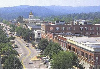
Waynesville is the county seat of Haywood County, North Carolina. It is the largest town in North Carolina west of Asheville. Waynesville is located about 30 miles (50 km) southwest of Asheville between the Great Smoky and Blue Ridge Mountains.

<span class="mw-page-title-main">Hendersonville, North Carolina</span> City in North Carolina, United States

Hendersonville is a city in and the county seat of Henderson County, North Carolina, United States, located 22 miles (35 km) south of Asheville. Like the county, the city is named for 19th-century North Carolina Supreme Court Chief Justice Leonard Henderson.

<span class="mw-page-title-main">Clinton, North Carolina</span> City in North Carolina, United States

Clinton is a city in and the county seat of Sampson County, North Carolina, United States. As of the 2020 census, the population was 8,383. Clinton is named for Richard Clinton, a Brigadier General of the North Carolina militia in the American Revolution.

<span class="mw-page-title-main">Laurinburg, North Carolina</span> City in North Carolina, United States

Laurinburg is a city in and the county seat of Scotland County, North Carolina, United States. Located in southern North Carolina near the South Carolina border, Laurinburg is southwest of Fayetteville and is home to St. Andrews University. The population at the 2010 census was 15,962 people.

<span class="mw-page-title-main">Rosman, North Carolina</span> Town in North Carolina, United States

Rosman is a town in Transylvania County, North Carolina, United States. The population was 576 at the 2010 census. The northern terminus of U.S. Route 178 is less than one mile northwest of Rosman on U.S. Route 64.

<span class="mw-page-title-main">Travelers Rest, South Carolina</span> City in South Carolina, United States

Travelers Rest is a city in Greenville County, South Carolina. The population was 7,788 at the 2020 census. It is part of the Greenville-Mauldin-Easley Metropolitan Statistical Area. Travelers Rest, the northernmost city in Greenville County, is located 10 miles north of Greenville and around 20 miles south of the North Carolina border. Furman University, a private liberal-arts university, was annexed into the city limits of Travelers Rest in April 2018 and North Greenville University, a private Christian institution, is located in nearby Tigerville.

<span class="mw-page-title-main">Asheville metropolitan area</span> Metropolitan area in North Carolina, United States

The Asheville metropolitan area is a metropolitan area centered on the principal city of Asheville, North Carolina. The U.S. Office of Management and Budget defines the Asheville, NC Metropolitan Statistical Area, a metropolitan statistical area used by the United States Census Bureau and other entities, as comprising the four counties of Buncombe, Haywood, Henderson, and Madison. The area's population was 424,858 according to the 2010 census, and 469,454 according to the 2020 census.

References

  1. 1 2 3 "North Carolina Gazetteer" . Retrieved December 25, 2020.
  2. "ArcGIS REST Services Directory". United States Census Bureau. Retrieved September 20, 2022.
  3. 1 2 U.S. Geological Survey Geographic Names Information System: Brevard, North Carolina
  4. 1 2 "U.S. Census website". United States Census Bureau . Retrieved January 31, 2008.
  5. "Find a County". National Association of Counties. Archived from the original on June 15, 2011. Retrieved June 7, 2011.
  6. "White Squirrels".
  7. "About Brevard | Brevard, NC - Official Website". cityofbrevard.com. Retrieved October 25, 2019.
  8. "Brevard city North Carolina QuickFacts from the US Census Bureau". Archived from the original on January 6, 2012.
  9. Gordon, Mary Jo (August 27, 2012). "FAQ - Brevard North Carolina". explorebrevard.com. Retrieved August 10, 2022.
  10. "NowData - NOAA Online Weather Data". National Oceanic and Atmospheric Administration. Retrieved August 16, 2021.
  11. "Station: Brevard, NC". U.S. Climate Normals 2020: U.S. Monthly Climate Normals (1991-2020). National Oceanic and Atmospheric Administration. Retrieved August 16, 2021.
  12. "Census of Population and Housing". Census.gov. Retrieved June 4, 2015.
  13. "Explore Census Data". data.census.gov. Retrieved December 19, 2021.
  14. "White Squirrel Festival".
  15. White Squirrels: Brevard, NC. History of the White Squirrel [ permanent dead link ]
  16. "White Squirrel Wars". RoadsideAmerica.com.
  17. "Halloweenfest". Archived from the original on October 15, 2014.
  18. "Twilight Tour 2016".
  19. Local Sculptor To Depart For Brevard's Sister City In Romania. The Transylvania Times. Retrieved Jul 22, 2020.