Rosman, North Carolina

Last updated

Rosman, North Carolina
Rosman-welcome-sign-nc.jpg
Welcome sign in Rosman
NCMap-doton-Rosman.PNG
Location of Rosman, North Carolina
Coordinates: 35°08′45″N82°49′13″W / 35.14583°N 82.82028°W / 35.14583; -82.82028
CountryUnited States
State North Carolina
County Transylvania
Incorporated1901 [1]
Named for Joseph Rosenthal and Morris Ormansky [1]
Area
[2]
  Total0.55 sq mi (1.41 km2)
  Land0.55 sq mi (1.41 km2)
  Water0.00 sq mi (0.00 km2)
Elevation
[3]
2,290 ft (700 m)
Population
 (2020)
  Total701
  Density1,283.88/sq mi (495.75/km2)
Time zone UTC−5 (Eastern (EST))
  Summer (DST) UTC−4 (EDT)
ZIP code
28772
Area code 828
FIPS code 37-58020 [4]
GNIS feature ID2407248 [3]

Rosman is a town in Transylvania County, North Carolina, United States. The population was 576 at the 2010 census. The northern terminus of U.S. Route 178 is less than one mile northwest of Rosman on U.S. Route 64.

Contents

The Pisgah Astronomical Research Institute is located approximately six miles north of Rosman, near Balsam Grove.

History

Known first by European Americans as Jeptha, the settlement was known as "Toxaway" in the early 20th century. Because this caused confusion with the nearby resort town of Lake Toxaway (10 miles to the west), in 1903 the name was changed to "Eastatoe," the name of a historic Cherokee town in the area. It was also the name for nearby Eastatoe Gap and Eastatoe Falls. The Cherokee word for the Carolina parakeet was eastatoe.

Town residents promoted another change, and Joseph Silversteen (a local industrialist) suggested Rosman in 1905, after two of his business associates, Joseph Rosenthal and Morris Osmansky. This was approved.

Geography

According to the United States Census Bureau, the town has a total area of 0.4 square miles (1.0 km2), all land.

Within the town limits of Rosman and to the south of the town limits, U.S. Route 178 is called Pickens Highway, referring to Pickens, South Carolina. South of Rosman, the highway continues across mountainous terrain through a series of switchback curves into South Carolina, eventually reaching Pickens.

Rosman sits on the eastern boundary of Pisgah National Forest.

The French Broad River runs through the town of Rosman. The river's origin, where the North Fork French Broad and the West Fork French Broad converge to form the river proper, lies just west of the town. A USGS stream gauge station, number 03439000, is located on the French Broad River in Rosman.

The climate is very wet, with a mean annual rainfall since 1936 of 79.54 inches (2,020.3 mm)—one of the highest in the US east of the Cascades. [5] The record annual rainfall of 129.60 inches (3,291.8 mm) in 1964 is the second heaviest for a calendar year within this region, only 0.54 inches (13.7 mm) behind Mount Washington’s record from 1969. [6]

Demographics

Historical population
CensusPop.Note
1910 145
1920 527263.4%
1930 484−8.2%
1940 5299.3%
1950 5351.1%
1960 419−21.7%
1970 407−2.9%
1980 51225.8%
1990 385−24.8%
2000 49027.3%
2010 57617.6%
2020 70121.7%
U.S. Decennial Census [7]

2020 census

Rosman racial composition [8]
RaceNumberPercentage
White (non-Hispanic)56881.03%
Black or African American (non-Hispanic)152.14%
Native American 71.0%
Other/Mixed 446.28%
Hispanic or Latino 679.56%

As of the 2020 United States census, there were 701 people, 240 households, and 104 families residing in the town.

2000 census

As of the census [4] of 2000, there were 490 people, 210 households, and 149 families residing in the town. The population density was 1,140.7 inhabitants per square mile (440.4/km2). There were 236 housing units at an average density of 549.4 per square mile (212.1/km2). The racial makeup of the town was 98.57% White, 0.20% Asian, and 1.22% from two or more races. Hispanic or Latino of any race were 1.22% of the population.

There were 210 households, out of which 33.3% had children under the age of 18 living with them, 46.2% were married couples living together, 20.5% had a female householder with no husband present, and 28.6% were non-families. 24.8% of all households were made up of individuals, and 11.0% had someone living alone who was 65 years of age or older. The average household size was 2.33 and the average family size was 2.77.

In the town, the population was spread out, with 26.1% under the age of 18, 7.6% from 18 to 24, 28.6% from 25 to 44, 20.8% from 45 to 64, and 16.9% who were 65 years of age or older. The median age was 37 years. For every 100 females, there were 89.9 males. For every 100 females age 18 and over, there were 89.5 males.

The median income for a household in the town was $20,179, and the median income for a family was $24,219. Males had a median income of $21,500 versus $21,042 for females. The per capita income for the town was $9,626. About 23.1% of families and 25.9% of the population were below the poverty line, including 25.6% of those under age 18 and 35.8% of those age 65 or over.

Camps

Rosman is home to The Wilds Christian Camp and Conference Center, as well as Ridge Haven.

Schools

The schools in the Rosman area include Rosman Elementary & TC Henderson Elementary, Rosman Middle and Rosman High School. Rosman's athletic teams are nicknamed the Tigers.

Related Research Articles

<span class="mw-page-title-main">Pickens County, South Carolina</span> County in South Carolina, United States

Pickens County is located in the northwest part of the U.S. state of South Carolina. As of the 2020 census, its population was 131,404. Its county seat is Pickens. The county was created in 1826. It is part of the Greenville-Anderson-Greer, SC Metropolitan Statistical Area.

<span class="mw-page-title-main">Oconee County, South Carolina</span> County in South Carolina, United States

Oconee County is the westernmost county in the U.S. state of South Carolina. As of the 2020 census, the population was 78,607. Its county seat is Walhalla and its largest community is Seneca. Oconee County is included in the Seneca, SC Micropolitan Statistical Area, which is also included in the Greenville-Spartanburg-Anderson, SC Combined Statistical Area. South Carolina Highway 11, the Cherokee Foothills National Scenic Highway, begins in southern Oconee County at Interstate Highway 85 at the Georgia state line.

<span class="mw-page-title-main">Yancey County, North Carolina</span> County in North Carolina, United States

Yancey County is a county located in the U.S. state of North Carolina. As of the 2020 census, the population was 18,470. Its county seat is Burnsville.

<span class="mw-page-title-main">Transylvania County, North Carolina</span> County in North Carolina, United States

Transylvania County is a county in the U.S. state of North Carolina. As of the 2020 census the population is 32,986. Its county seat is Brevard.

<span class="mw-page-title-main">Madison County, North Carolina</span> County in North Carolina, United States

Madison County is a county located in the U.S. state of North Carolina. As of the 2020 census, the population was 21,193. Its county seat is Marshall. Madison County is part of the Asheville, NC Metropolitan Statistical Area.

<span class="mw-page-title-main">Henderson County, North Carolina</span> County in North Carolina, United States

Henderson County is a county located in the U.S. state of North Carolina. As of the 2020 census, the population was 116,281. Its county seat is Hendersonville.

<span class="mw-page-title-main">Haywood County, North Carolina</span> County in North Carolina, United States

Haywood County is a county located in the U.S. state of North Carolina. As of the 2020 census, the population was 62,089. The county seat and its largest community is Waynesville.

<span class="mw-page-title-main">Buncombe County, North Carolina</span> County in North Carolina, United States

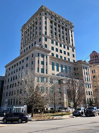
Buncombe County is a county located in the U.S. state of North Carolina. It is classified within Western North Carolina. The 2020 census reported the population was 269,452, making it the 7th-most populous county in North Carolina. Its county seat is Asheville. Buncombe County is part of the Asheville, NC Metropolitan Statistical Area.

<span class="mw-page-title-main">Towns County, Georgia</span> County in Georgia, United States

Towns County is a county located in the northeastern part of the U.S. state of Georgia. As of the 2020 census, the population was 12,493. Its county seat is Hiawassee. The county was created on March 6, 1856, and named for lawyer, legislator, and politician George W. Towns.

<span class="mw-page-title-main">Pickens County, Georgia</span> County in Georgia, United States

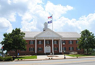
Pickens County is a county located in the north-central portion of the U.S. state of Georgia. As of the 2020 census, the population was 33,216. The county seat is Jasper. Pickens County is part of the Atlanta-Sandy Springs-Roswell, Georgia metropolitan statistical area.

<span class="mw-page-title-main">Gordon County, Georgia</span> County in Georgia, United States

Gordon County is a county located in the northwestern part of the U.S. state of Georgia. As of the 2020 census, the population was 57,544. The county seat is Calhoun. Gordon County comprises the Calhoun, GA Micropolitan Statistical Area, which is included in the Atlanta–Athens-Clarke County–Sandy Springs, GA-AL CSA.

<span class="mw-page-title-main">Nelson, Georgia</span> City in Georgia, United States

Nelson is a city in Pickens and Cherokee Counties, Georgia, United States. At the 2020 census, the population was 1,145. It is part of the Atlanta metropolitan area.

<span class="mw-page-title-main">Black Mountain, North Carolina</span> Town in North Carolina

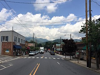
Black Mountain is a town in Buncombe County, North Carolina, United States. The population was 8,426 at the 2020 United States census. It is part of the Asheville Metropolitan Statistical Area. The town is named for the old train stop at the Black Mountain Depot and is located at the southern end of the Black Mountain range of the Blue Ridge Mountains in the Southern Appalachians.

<span class="mw-page-title-main">Canton, North Carolina</span> Town in North Carolina, United States

Canton is the second largest town in Haywood County, North Carolina, United States. It is located about 17 miles (27 km) west of Asheville and is part of that city's metropolitan area. The town is named after the city of Canton, Ohio. The population was 4,422 at the 2020 census.

<span class="mw-page-title-main">Clyde, North Carolina</span> Town in North Carolina, United States

Clyde is a town in Haywood County, North Carolina, United States. The 2010 census recorded the population at 1,223 people. It is part of the Asheville Metropolitan Statistical Area.

<span class="mw-page-title-main">Brevard, North Carolina</span> City in North Carolina, United States

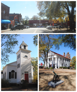
Brevard is a city and the county seat of Transylvania County, North Carolina, United States, with a population of 7,609 as of the 2010 census.

<span class="mw-page-title-main">Pendleton, South Carolina</span> Town in South Carolina, United States

Pendleton is a town in Anderson County, South Carolina, United States. The population was 3,489 at the 2020 census. It is a sister city of Stornoway in the Outer Hebrides of Scotland.

Parker is a census-designated place (CDP) in Greenville County, South Carolina, United States. The population was 11,431 at the 2010 census, up from 10,760 in 2000. It is part of the Greenville–Mauldin–Easley Metropolitan Statistical Area.

<span class="mw-page-title-main">Seneca, South Carolina</span> City in Oconee County, South Carolina

Seneca is a city in Oconee County, South Carolina, United States. The population was 8,102 at the 2010 census. It is the principal city of the Seneca Micropolitan Statistical Area, an (MSA) that includes all of Oconee County, and that is included within the greater Greenville-Spartanburg-Anderson, South Carolina Combined Statistical Area. Seneca was named for the nearby Cherokee town of Isunigu, which English colonists knew as "Seneca Town".

<span class="mw-page-title-main">Pickens, South Carolina</span> City in South Carolina, United States

Pickens, formerly called Pickens Courthouse, is a city in and the county seat of Pickens County, South Carolina, United States. The population was 3,126 at the 2010 census. Pickens changed its classification from a town to a city in 1998, but it was not reported to the Census Bureau until 2001. It was named after Andrew Pickens (1739–1817), an American revolutionary soldier and US Congressman for South Carolina.

References

  1. 1 2 "North Carolina Gazetteer" . Retrieved December 25, 2020.
  2. "ArcGIS REST Services Directory". United States Census Bureau. Retrieved September 20, 2022.
  3. 1 2 U.S. Geological Survey Geographic Names Information System: Rosman, North Carolina
  4. 1 2 "U.S. Census website". United States Census Bureau . Retrieved January 31, 2008.
  5. National Oceanic and Atmospheric Administration, NOW Data – NOAA Only Weather Data
  6. Maximum Annual Precipitation by State
  7. "Census of Population and Housing". Census.gov. Retrieved June 4, 2015.
  8. "Explore Census Data". data.census.gov. Retrieved December 19, 2021.