Burnsville, North Carolina

Last updated

Burnsville, North Carolina
Burnsville, NC Town Square-Statue of Otway Burns.jpg
Burnsville Town Square
Burnsville, NC Town Seal.webp
NCMap-doton-Burnsville.PNG
Location of Burnsville, North Carolina
Coordinates: 35°54′59″N82°17′52″W / 35.91639°N 82.29778°W / 35.91639; -82.29778 [1]
Country United States
State North Carolina
County Yancey
Area
[2]
  Total1.60 sq mi (4.14 km2)
  Land1.60 sq mi (4.14 km2)
  Water0.00 sq mi (0.00 km2)
Elevation
[1]
2,749 ft (838 m)
Population
 (2020)
  Total1,614
  Density1,008.75/sq mi (389.40/km2)
Time zone UTC-5 (Eastern (EST))
  Summer (DST) UTC-4 (EDT)
ZIP code
28714
Area code 828
FIPS code 37-09140 [3]
GNIS feature ID2405350 [1]
Website townofburnsville.org

Burnsville is a town that serves as the county seat of Yancey County, North Carolina, United States. [4] Located in the Blue Ridge Mountains of western North Carolina, sits in the shadow of Mount Mitchell, the highest peak in the Eastern Continental United States. The population was 1,612 at the 2020 census.

Contents

History

The town was founded on March 6, 1834, from land conveyed by John "Yellow Jacket" Bailey, and it was named after Captain Otway Burns, a naval hero of the War of 1812. In 1909, a statue of Captain Burns was given to the town by his grandson, Walter Francis Burns Sr., and it was set on a granite pedestal in the center of the town square. It has an inscription that reads, in part, "He Guarded Well Our Seas, Let Our Mountains Honor Him." Due to damages, the original statue was replaced in the early 2000s.

On April 6, 2010, Burnsville, the only incorporated town within Yancey County, held a referendum providing for the legal sale of alcohol within the town limits. The referendum passed. After applying for and receiving the applicable permits, Burnsville now operates an ABC store; some retail establishments now sell beer and wine; and a few restaurants sell beer, wine, and mixed drinks. Graham County is the last remaining fully dry county in the state of North Carolina. [5]

Historic structures

One of the oldest buildings is the Nu-Wray Inn. It was built in 1833 and now, is listed on the National Register of Historic Places. The Parkway Playhouse, the oldest continually operating summer stock theater company in North Carolina, is located in Burnsville. It was founded in 1947 by W. R. Taylor, a professor of drama from the Woman's College of North Carolina-now the University of North Carolina-Greensboro, and a group of dedicated community leaders. Several other structures in Burnsvile are listed on the National Register of Historic Places. They include the Bald Creek Historic District, Chase-Coletta House, Citizens Bank Building, John Wesley McElroy House, Yancey Collegiate Institute Historic District, and Yancey County Courthouse. [6]

Annual fair

2014 Mt. Mitchell Crafts Fair Mt. Mitchell Crafts Fair 2014.jpg
2014 Mt. Mitchell Crafts Fair

The Mt. Mitchell Craft Fair is held in Burnsville. This annual event, founded in 1956, attracts thousands of tourists and more than 200 vendors and performers. The fair is known for the local and visiting artisans who exhibit their handmade arts and crafts.

Established in 1956, The Mount Mitchell Arts & Crafts Fair is coordinated and sponsored by the Burnsville-Yancey Chamber of Commerce. It is the first Friday and Saturday in August in historic downtown Burnsville and features more than 200 vendors and performers. The event includes bluegrass and acoustic music, food vendors, and a unique selection of handmade arts and crafts from artisans across the country.

The Mt. Mitchell Arts & Crafts Fair brings together mountain heritage, traditional crafting, and contemporary art creating an event not to be missed. [7]

Geography

Burnsville is located in the mountains of western North Carolina, at 2,825 feet above sea level. It is on a tributary of the Cane River, just north of the Black Mountains, [8] and 30 miles northeast of Asheville. U.S. Highway 19E runs through the town, leading to Interstate 26 and Mars Hill to the west and, to the east, to Spruce Pine.

According to the United States Census Bureau, the town has a total area of 1.6 square miles (4.1 km2), all land.

Demographics

Historical population
CensusPop.Note
1900 207
1910 422103.9%
1930 866
1940 99715.1%
1950 1,34134.5%
1960 1,3883.5%
1970 1,348−2.9%
1980 1,4527.7%
1990 1,4822.1%
2000 1,6239.5%
2010 1,6934.3%
2020 1,614−4.7%
U.S. Decennial Census [9]

2020 census

Burnsville racial composition [10]
RaceNumberPercentage
White (non-Hispanic)1,37485.13%
Black or African American (non-Hispanic)261.61%
Native American 100.62%
Asian 110.68%
Pacific Islander 10.06%
Other/Mixed 513.16%
Hispanic or Latino 1418.74%

As of the 2020 United States census, there were 1,614 people, 822 households, and 520 families residing in the town.

2000 census

As of the census [3] of 2000, there were 1,623 people, 748 households, and 412 families residing in the town. The population density was 1,028.0 inhabitants per square mile (396.9/km2). There were 845 housing units at an average density of 535.2 per square mile (206.6/km2). The racial makeup of the town was 95.50% White, 1.91% African American, 0.49% Native American, 0.43% Asian, 0.86% from other races, and 0.80% from two or more races. Hispanic or Latino of any race were 3.88% of the population.

There were 748 households, out of which 21.9% had children under the age of 18 living with them, 41.2% were married couples living together, 11.6% had a female householder with no husband present, and 44.9% were non-families. 42.1% of all households were made up of individuals, and 25.1% had someone living alone who was 65 years of age or older. The average household size was 2.00 and the average family size was 2.70.

In the town, the population was spread out, with 18.1% under the age of 18, 5.7% from 18 to 24, 22.4% from 25 to 44, 23.2% from 45 to 64, and 30.7% who were 65 years of age or older. The median age was 48 years. For every 100 females, there were 75.3 males. For every 100 females age 18 and over, there were 70.8 males.

The median income for a household in the town was $21,653, and the median income for a family was $34,712. Males had a median income of $30,227 versus $25,234 for females. The per capita income for the town was $16,894. About 15.3% of families and 19.5% of the population were below the poverty line, including 24.2% of those under age 18 and 19.4% of those age 65 or over.

Education

Burnsville is served by the Yancey County Schools System. Mountain Heritage High School, Yancey County's public high school is located outside the town limits to the west on Highway 19E, as is a satellite campus of Mayland Community College. Burnsville Elementary School and East Yancey Middle School lie to the east of the town limits.

Economy

Altec and Glen Raven are manufacturing employers in Burnsville. Glen Raven is the only operating textile factory in the county. [11] [12] Formerly, Burnsville had two textile mills, with Avondale Mills and Glen Raven, Inc. each operating a mill in the town. The closures of the Avondale Mills facility and Taylor Togs' Micaville blue jeans factory occurred in 2004.

Points of interest

Development

In 2006, the North Carolina Department of Transportation began widening U.S. 19 and U.S. 19E from a two-lane highway to a four-lane divided highway. The construction began at the junction of Interstate 26 in Madison County and continued to where U.S. 19E intersects with Jacks Creek Road. Construction on this section was completed and was dedicated on November 2, 2012. [13] Work on widening the next section to the Micaville intersection was completed and opened to a four-lane traffic pattern over the weekend of October 29–30, 2016. [14]

Related Research Articles

<span class="mw-page-title-main">Oconee County, South Carolina</span> County in South Carolina, United States

Oconee County is the westernmost county in the U.S. state of South Carolina. As of the 2020 census, the population was 78,607. Its county seat is Walhalla and its largest community is Seneca. Oconee County is included in the Seneca, SC Micropolitan Statistical Area, which is also included in the Greenville-Spartanburg-Anderson, SC Combined Statistical Area. South Carolina Highway 11, the Cherokee Foothills National Scenic Highway, begins in southern Oconee County at Interstate Highway 85 at the Georgia state line.

<span class="mw-page-title-main">Yancey County, North Carolina</span> County in North Carolina, United States

Yancey County is a county located in the U.S. state of North Carolina. As of the 2020 census, the population was 18,470. Its county seat is Burnsville.

<span class="mw-page-title-main">Mitchell County, North Carolina</span> County in North Carolina, United States

Mitchell County is a county located in the U.S. state of North Carolina. As of the 2020 census, the population was 14,903. Its county seat is Bakersville.

<span class="mw-page-title-main">Caldwell County, North Carolina</span> County in North Carolina, United States

Caldwell County is a county in the U.S. state of North Carolina. It is located in the foothills of the Blue Ridge Mountains. As of the 2020 census, the population was 80,652. Its county seat is Lenoir. Caldwell County is part of the Hickory-Lenoir-Morganton, NC Metropolitan Statistical Area.

<span class="mw-page-title-main">Avery County, North Carolina</span> County in North Carolina, United States

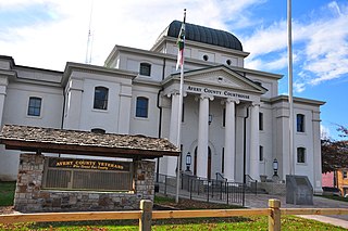
Avery County is a county located in the U.S. state of North Carolina. As of the 2020 census, the population was 17,806. The county seat is Newland. The county seat was initially established in Elk Park when the county was first formed, but was moved to Newland upon completion of the courthouse in 1912. Founded in 1911, it is the youngest of North Carolina's 100 counties.

<span class="mw-page-title-main">Yanceyville, North Carolina</span> Town in North Carolina, United States

Yanceyville is a town in and the county seat of Caswell County, North Carolina, United States. Located in the Piedmont Triad region of the state, the town had a population of 1,937 at the 2020 census.

<span class="mw-page-title-main">Hope Mills, North Carolina</span> Town in North Carolina, United States

Hope Mills is a town in Cumberland County, North Carolina, United States. Its population was 15,176 at the 2010 census.

<span class="mw-page-title-main">Sylva, North Carolina</span> Town in North Carolina, United States

Sylva is an incorporated town located in central Jackson County, in the Plott Balsam Mountains of Western North Carolina, United States. As of the 2010 census, the town had a total population of 2,588. It is the county seat, taking over the role from nearby Webster in 1913.

<span class="mw-page-title-main">Bakersville, North Carolina</span> Town in North Carolina, United States

Bakersville is a town in Mitchell County, North Carolina, United States. The population was 464 at the 2010 census. It is the county seat of Mitchell County.

<span class="mw-page-title-main">Spruce Pine, North Carolina</span> Town in North Carolina, United States

Spruce Pine is the largest town in Mitchell County, North Carolina, United States. The population was 2,175 at the 2010 census.

<span class="mw-page-title-main">Mitchell, Oregon</span> City in Oregon, United States

Mitchell is a city in Wheeler County, Oregon, United States. The population was 130 at the 2010 census. It was founded in 1873 and was named after John H. Mitchell, a politician.

<span class="mw-page-title-main">Roan Mountain, Tennessee</span> CDP in Tennessee, United States

Roan Mountain is a census-designated place (CDP) in Carter County, Tennessee, United States. The population was 1,360 at the 2010 census. It is part of the Johnson City Metropolitan Statistical Area, which is a component of the Johnson City–Kingsport–Bristol, TN-VA Combined Statistical Area – commonly known as the Tri-Cities region.

<span class="mw-page-title-main">Hillsboro, West Virginia</span> Town in West Virginia, United States

Hillsboro is a town in Pocahontas County, West Virginia, United States. The population was 232 at the 2020 census.

<span class="mw-page-title-main">U.S. Route 19E</span> Suffixed section of U.S. Highway in Tennessee and North Carolina

U.S. Route 19E (US 19E) is a divided highway of US 19 in the U.S. states of North Carolina and Tennessee. The United States Numbered Highway, which is complemented by US 19W to the west, travels 75.9 miles (122.1 km) from US 19 and US 19W at Cane River, North Carolina, north to US 11E, US 19, and US 19W in Bluff City, Tennessee. US 19E connects Asheville, North Carolina, and Bristol, Tennessee, with Burnsville, Spruce Pine, and Elk Park in North Carolina and Roan Mountain and Elizabethton in Tennessee. US 19E also has an unsigned concurrency with State Route 37 (SR 37) for its entire course in Tennessee.

<span class="mw-page-title-main">Western North Carolina</span> Geographic region of the U.S. state of North Carolina

Western North Carolina is the region of North Carolina which includes the Appalachian Mountains; it is often known geographically as the state's Mountain Region. It contains the highest mountains in the Eastern United States, with 125 peaks rising to over 5,000 feet in elevation. Mount Mitchell at 6,684 feet, is the highest peak of the Appalachian Mountains and mainland eastern North America. The population of the 23 most commonly associated counties for the region, as measured by the 2020 U.S. Census, is 1,149,405. The region accounts for approximately 11% of North Carolina's total population.

Three Mile is an unincorporated community in Avery County, North Carolina, United States. The community is located along NC 194 ; the name is derived from the air miles-straight-line distance of three miles between US 19-E to US 221.

<span class="mw-page-title-main">U.S. Route 19 in North Carolina</span> Segment of American highway

U.S. Highway 19 (US 19) traverses 145 miles (233 km) across Western North Carolina; from the Georgia state line, at the community of Bellview, to Cane River, where US 19 splits into US 19E and US 19W, which take separate routes into Tennessee.

<span class="mw-page-title-main">Micaville, North Carolina</span> Unincorporated community in North Carolina, United States

Micaville is an unincorporated community in the Crabtree Township of Yancey County, North Carolina, United States. The name comes from a mineral mined there called mica. It was the central mining location in the county.

<span class="mw-page-title-main">North Carolina Highway 80</span> State highway in North Carolina, US

North Carolina Highway 80 (NC 80) is a primary state highway in the U.S. state of North Carolina. The highway connects the various mountain communities straddled along Buck Creek, South Toe River and North Toe River in Western North Carolina and serves as a direct route, via the Blue Ridge Parkway, to Mount Mitchell State Park.

The Yancey Railroad was an American Class III shortline railroad that operated for freight service from a connection with the Clinchfield Railroad at Kona, North Carolina, through Micaville, to Burnsville, 10.6 miles (17.1 km). A short branch ran from Micaville to Bowditch, North Carolina, 2.11 miles (3.40 km). Total mileage was 12.83 miles (20.65 km). Rail was 60–65 pounds and the maximum load limit was 75 tons. Traffic was feldspar, mica, fertilizer, building materials, livestock feed and steel spring wire.

References

  1. 1 2 3 U.S. Geological Survey Geographic Names Information System: Burnsville, North Carolina
  2. "ArcGIS REST Services Directory". United States Census Bureau. Retrieved September 20, 2022.
  3. 1 2 "U.S. Census website". United States Census Bureau . Retrieved January 31, 2008.
  4. "Find a County". National Association of Counties. Archived from the original on May 31, 2011. Retrieved June 7, 2011.
  5. "Burnsville voters approve alcohol sales". Asheville Citizen-Times.com. Archived from the original on May 10, 2014. Retrieved May 10, 2014.
  6. "National Register Information System". National Register of Historic Places . National Park Service. July 9, 2010.
  7. "Mount Mitchell Crafts Fair". Town of Burnsville, NC. Retrieved July 17, 2022.
  8. Burnsville, NC, 7.5 Minute Topographic Quadrangle, USGS, 1998
  9. "Census of Population and Housing". Census.gov. Retrieved June 4, 2015.
  10. "Explore Census Data". data.census.gov. Retrieved December 19, 2021.
  11. "Commerce Lets Failed Expo Center Slide". www.carolinajournal.com. Retrieved February 6, 2019.
  12. "The Quiet Mountain Town of Burnsville Sees Growth". Our State Magazine. July 2, 2013. Retrieved February 6, 2019.
  13. "Gov. Perdue and Transportation Secretary Conti Join State and Local Officials to Celebrate Completion of First Section of U.S. 19 Widening Project in Madison and Yancey Counties". NC DOT News Release. North Carolina Department of Transportation. Archived from the original on May 12, 2014. Retrieved May 10, 2014.
  14. "Roadway traffic switches to four lane pattern, finally]". Yancey Times Journal. October 2, 2016. Retrieved October 4, 2016.[ permanent dead link ]