
Yancey County is a county located in the U.S. state of North Carolina. As of the 2020 census, the population was 18,470. Its county seat is Burnsville.

Burnsville is a town that serves as the county seat of Yancey County, North Carolina, United States. The population was 1,612 at the 2020 census.
Copen is an unincorporated community in Braxton County, central West Virginia, United States. The community is located at the confluence of Copen and Bull Fork Creeks. Its most famous resident was Melvin Wine (1909–2003), an acclaimed old-time fiddler.

U.S. Route 19E (US 19E) is a divided highway of US 19 in the U.S. states of North Carolina and Tennessee. The United States Numbered Highway, which is complemented by US 19W to the west, travels 75.9 miles (122.1 km) from US 19 and US 19W at Cane River, North Carolina, north to US 11E, US 19, and US 19W in Bluff City, Tennessee. US 19E connects Asheville, North Carolina, and Bristol, Tennessee, with Burnsville, Spruce Pine, and Elk Park in North Carolina and Roan Mountain and Elizabethton in Tennessee. US 19E also has an unsigned concurrency with State Route 37 (SR 37) for its entire course in Tennessee.

Waterrock Knob is a mountain peak in the U.S. state of North Carolina. It is the highest peak in the Plott Balsams and is the 16th-highest mountain in the Eastern United States.
Boomer is a farming community located in Wilkes County, North Carolina. Legally it is a township, a non-governmental county subdivision. The population was 1,266 at the 2020 Census.
The Sauratown Mountains, which are sometimes called "the mountains away from the mountains", are an isolated mountain range located within Stokes and Surry counties in the U.S. state of North Carolina. The vast majority of the range is located in Stokes County. Although the range occupies only 5% of Stokes County's area, it dominates the county's scenery from almost every direction. The Sauras rise sharply 800 to 1,700 feet above the surrounding terrain.
Lowgap is an unincorporated community in the Franklin Township of Surry County, North Carolina, United States. Originally settled by the Galyean and Edwards families, Lowgap is named for the "low gap" the community is settled in among the Blue Ridge Mountains. The community is located at an elevation of 1,440 feet. Landmarks near the center of the community include the community post office, the community library housed in the former Lowgap School, fire department, and area churches. Locally owned businesses such as L&H Enterprises, and Bottomley Enterprises employ many of the citizens who reside here. North Carolina Highway 89, also known as West Pine Street, serves as the main thoroughfare in the community.

Woody's Knob, at an elevation of 4,170 feet, is a summit or "knob" in the Blue Ridge Mountains and one of the highest points in the unincorporated village of Little Switzerland and in Mitchell County, North Carolina.

North Carolina Highway 197 is a South-to-North state highway in Western North Carolina. The route is approximately 58 miles (93 km) in length and with its continuation into Tennessee as SR 395 connects Erwin, Tennessee to Flat Creek, North Carolina. Portions of this highway lie within the Pisgah National Forest and is one of the few highways in the state with an unpaved portion.
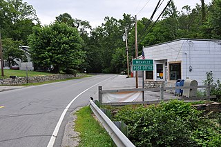
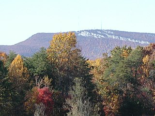
Micaville is an unincorporated community in Yancey County, North Carolina, United States. The name comes from a mineral mined there called mica. It was the central mining location in the county.

The Nu Wray Inn is an historic hotel located at Burnsville, Yancey County, North Carolina. It was built in 1833 at the time Yancey County was formed and a year before Burnsville was established. It was originally built of logs and had eight bedrooms and a dining room and kitchen. It was listed on the National Register of Historic Places in 1982.
Cane River is an unincorporated community in Yancey County, North Carolina, United States. It is located west of Burnsville, at the intersection of U.S. Routes 19, 19E and 19W, along the Cane River.
The Yancey Railroad was an American Class III shortline railroad that operated for freight service from a connection with the Clinchfield Railroad at Kona, North Carolina, through Micaville, to Burnsville, 10.6 miles (17.1 km). A short branch ran from Micaville to Bowditch, North Carolina, 2.11 miles (3.40 km). Total mileage was 12.83 miles (20.65 km). Rail was 60–65 pounds and the maximum load limit was 75 tons. Traffic was feldspar, mica, fertilizer, building materials, livestock feed and steel spring wire.
Turnersburg is an unincorporated community in Iredell County, North Carolina, United States. The community is located on U.S. Route 21, 9.8 miles (15.8 km) north-northeast of Statesville. Turnersburg has a post office with ZIP code 28688.

Upper Strasburg is an unincorporated community that is located in Letterkenny Township in Franklin County, Pennsylvania, United States.
The Cane River is a 38.3-mile (61.6 km) river in Yancey County, North Carolina. It originates from the confluence of Beech Nursery Creek, off the western slope of Mount Mitchell, and Blue Sea Creek, off the northeastern slope of Blackstock Knob, in the Black Mountains. A tributary in the French Broad River basin, it flows northward to join the North Toe River, forming the Nolichucky River.
Higgins is a populated place in Egypt township in Yancey County, North Carolina, United States. Already in decline in the 1920s, it was revived by a Presbyterian missionary who obtained support from the Markle Foundation in the 1930s, but has since been largely abandoned. Under the name of "Henry", it was a case study in Cities and the Wealth of Nations, by Jane Jacobs, who spent six months there in 1934.

Kona is an unincorporated community in Mitchell County, North Carolina, United States. The community is located along North Carolina Highway 80 (NC 80), near the confluence of the North and South Toe Rivers and at the western slope of Ellis Mountain.

