A survey township is simply a geographic reference used to define property location for deeds and grants as surveyed and platted by the General Land Office (GLO). A survey township is nominally six by six miles square, or 23,040 acres.
A civil township is a unit of local government, generally a civil division of a county. Counties are the primary divisional entities in many states, thus the powers and organization of townships varies from state to state. Civil townships are generally given a name, sometimes written with the included abbreviation "Twp".
A charter township, found only in the state of Michigan, is similar to a civil township. Provided certain conditions are met, a charter township is mostly exempt from annexation to contiguous cities or villages, and carries additional rights and responsibilities of home rule.
Diagram of survey townshipHierarchy of systemic numbering in the PLSS
Survey townships are generally referred to by a number based on the Public Land Survey System (PLSS). A reference to the township will look something like "Township 2 North Range 3 East", or "T2N,R3E" and such a notation is used in property descriptions based on the PLSS. Townships were originally surveyed and platted by the United States General Land Office, using contracted private survey crews, and are marked on the United States Geological Survey maps of the United States.
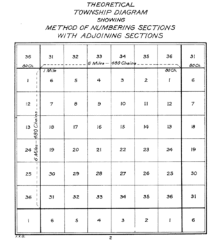
Townships are normally a square approximately six miles (9.7km) on a side with cardinal boundaries conforming to meridians and parallels, containing 36 sections of one square mile (2.6km2) each. The northern and westernmost tier of sections in each township are designed to take up the convergence of the east and west township boundary lines or range lines, as well as any error in the survey measurements, and therefore these sections vary slightly from being one square mile or 640 acres (260ha). Survey townships exist in some form in most states other than the original Thirteen Colonies, Kentucky, Tennessee, Vermont, and Maine.[dubious–discuss] Irregular or fractional townships with fewer than a full 36sections are created where full townships cannot be laid out due to existing senior boundaries, such as Spanish/Mexican ranchos, Indian reservations, state boundary lines, etc.
In Kentucky, the Jackson Purchase (the area west of the Tennessee River) is divided into townships and ranges. In Tennessee, the entire state is surveyed into townships and ranges that make up 13 survey districts of the Tennessee State Survey. In extreme northern Maine there is an area divided into townships and ranges oriented to true north. A region in the central part of the state, made up of 17 surveys, is divided into townships, but these are not oriented to true north. The remainder of the state is on metes and bounds. Similarly, Vermont and New Hampshire are mostly metes-and-bounds states, but have areas in the north that are surveyed into townships not oriented to true north. Most of Ohio is surveyed using the Public Land Survey System, but several sizable areas are metes-and-bounds, including the Virginia Military Reserve, Donation Tract, French Grant and the three Moravian grants (Gnadenhutten, Schoenbrunn and Salem). A 150,000-acre (61,000ha) area in southern Indiana (Clark's Grant) is not surveyed into townships, but is still a gridded survey. Portions of the Texas State Survey use square townships. Sizeable portions of Alaska, Arizona, California, Idaho, Montana, Oregon and Washington, are unsurveyed. Substantial swampy areas in Florida and Louisiana are also unsurveyed.
Both New York and Pennsylvania have metes-and-bounds surveys, but in the western parts of these states, the metes-and-bounds form square townships many of which are also civil townships. Besides these, nearly every state has areas of metes-and-bounds that were never included in the grids (like along major rivers) or were removed from the grid, usually due to surveying mistakes.
The township government is a unit of local government, often rural. Townships are geographic and political subdivisions of a county. The township is identified by a name, such as Penn Township, Cumberland County, Pennsylvania. The responsibilities and the form of the township government is specified by the state legislature.
The most common form of township government has an elected board of trustees or supervisors. Some additional offices, such as clerk or constable, may also be elected. The most common governmental responsibilities of townships include oversight of such things as road maintenance, land-use planning, and trash collection. Many townships in Ohio, Michigan, New Jersey and Pennsylvania provide police and fire protection, similar to what an incorporated city would provide.
In most midwestern states, a civil township often corresponds to a single survey township, although in less populated areas, the civil township may be made up of all or portions of several survey townships. In areas where there are natural features such as a lake or river, the civil township boundaries may follow the geographic features rather than the survey township boundaries. Municipalities such as cities may incorporate or annex land in a township, which is then generally removed from township government. Only one state, Indiana, has township governments covering all its area and population.[2] In other states, some types of municipalities, like villages, remain a part of the township while cities are not. As urban areas expand, a civil township may entirely disappear—see, for example, Mill Creek Township, Hamilton County, Ohio. In other expanding urban areas, the township may incorporate itself into a city; this can be seen in the numerous square cities of Hennepin, Anoka, and Washington counties in Minnesota. The Montgomery County, Ohio, cities of Trotwood (1996, formerly Madison Township), Huber Heights (1980, Wayne Township), and Kettering (1955, Van Buren Township) are further examples of townships incorporating into cities.
Pennsylvania and New Jersey have civil townships that are not based on the PLSS survey system, but on the older metes and bounds survey system. A New Jersey township differs only in name from other municipalities: its boundaries are fixed, it is an incorporated body, and it is free to adopt another form of government. The federal government has frequently failed to allow for federal funding unless they went under a different name;[citation needed] some New Jersey municipalities, such as the Township of the Borough of Verona or Township of South Orange Village, changed their names to qualify for additional federal aid.
Utah and Nevada have areas called townships, but they are not the same as civil townships. These areas are not separate governments, but have been granted some degree of self-rule by a county.[citation needed]
Michigan has created charter townships as a separate type of government to allow greater flexibility for township governments to serve urbanized populations. In Michigan, as in other states with like systems (though sometimes different names), a township is an administrative division of a county, which is an administrative division of the state. Counties and townships are local organs through which state law and public policy are administered, adapted to local need to the extent the law allows. A charter township is a township that has been granted a charter, which allows it certain rights and responsibilities of home rule that are generally intermediary in scope between those of a city (a semi-autonomous jurisdiction in Michigan) and a village, which (unless it is a home-rule village) is subject to the authority of the township(s) in which it is located.
Towns and townships are sometimes considered minor civil divisions of counties by the United States Census Bureau for statistical purposes.[3] According to the Census Bureau, in 2002, town or township government applied to 16,504 organized governments in the following 20 states:
This categorization includes governmental units officially designated as "towns" in the New England states, New York, and Wisconsin, some plantations in Maine and locations in New Hampshire. In Minnesota, the terms town and township are used interchangeably with regard to township governments. Although towns in the six New England states and New York, and townships in New Jersey and Pennsylvania, are legally termed municipal corporations, perform municipal-type functions, and frequently serve densely populated urban areas, they have no necessary relation to concentration of population, and are thus counted for census purposes as town or township governments. Even in states beyond New England, townships often serve urbanized areas and provide municipal services typically provided by incorporated municipalities.
The count of 16,504 organized township governments does not include unorganized township areas (where the township may exist in name only, but has no organized government) or where the townships are coextensive with cities and the cities have absorbed the township functions. It also does not include the townships in Iowa (see Iowa townships), which are not separate governments, but are classified as subordinate agencies of county governments.
Of the 16,504 town or township governments, only 1,179 (7.1 percent) had as many as 10,000 inhabitants in the 2000 census and 52.4 percent of all towns or townships had fewer than 1000 inhabitants. There was a decline in the number of town or township governments from 16,629 in 1997 to 16,504 in 2002. Nearly all of the decline involved townships in the Midwest.
Usage by state
Because township government is defined by each state, the use of this form also varies by state. States using a township form include the following:
The form is used in parts of Illinois and also in Nebraska, where they are sometimes referred to as precincts. Two cases of this use of terminology are Edwards and Wabash counties in Illinois.
A township is a kind of human settlement or administrative subdivision, with its meaning varying in different countries.
LaPorte County is a county located in the U.S. state of Indiana. As of 2020, the population was 112,417. The county seat is the city of La Porte, and the largest city is Michigan City. This county is part of the Northwest Indiana and Michiana regions of the Chicago metropolitan area. The LaPorte County Courthouse is located in the county seat of La Porte and is listed on the National Register of Historic Places.
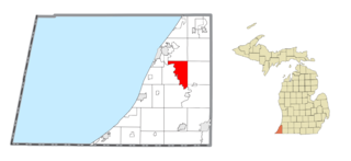
Sodus Township is a civil township of Berrien County in the U.S. state of Michigan. The population was 1,932 at the 2010 census. There are no incorporated municipalities in the township. The unincorporated community of Sodus in the northwest of the township is its main settlement; the portion of the township just to the west is part of the Benton Harbor/St. Joseph urban area.
Montague Township is a township in Sussex County, in the U.S. state of New Jersey, in the New York City Metropolitan Area. As of the 2020 United States census, the township's population was 3,792, a decrease of 55 (−1.4%) from the 2010 census count of 3,847, which in turn reflected an increase of 435 (+12.7%) from the 3,412 counted in the 2000 census. High Point, within Montague Township, is the highest elevation within New Jersey at an altitude of 1,803 feet (550 m) above sea level. Montague is also the northernmost municipality in the state of New Jersey.
Knowlton Township is a township in Warren County, in the U.S. state of New Jersey. As of the 2020 United States census, the township's population was 2,894, a decrease of 161 (−5.3%) from the 2010 census count of 3,055, which in turn reflected an increase of 78 (+2.6%) from the 2,977 counted in the 2000 census.
The Public Land Survey System (PLSS) is the surveying method developed and used in the United States to plat, or divide, real property for sale and settling. Also known as the Rectangular Survey System, it was created by the Land Ordinance of 1785 to survey land ceded to the United States by the Treaty of Paris in 1783, following the end of the American Revolution. Beginning with the Seven Ranges in present-day Ohio, the PLSS has been used as the primary survey method in the United States. Following the passage of the Northwest Ordinance in 1787, the Surveyor General of the Northwest Territory platted lands in the Northwest Territory. The Surveyor General was later merged with the General Land Office, which later became a part of the U.S. Bureau of Land Management (BLM). Today, the BLM controls the survey, sale, and settling of lands acquired by the United States.
A census-designated place (CDP) is a concentration of population defined by the United States Census Bureau for statistical purposes only.
A minor civil division (MCD) is a term used by the United States Census Bureau for primary governmental and/or administrative divisions of a county or county-equivalent, typically a municipal government such as a city, town, or civil township. MCDs are used for statistical purposes by the Census Bureau, and do not necessarily represent the primary form of local government. They range from non-governing geographical survey areas to municipalities with weak or strong powers of self-government. Some states with large unincorporated areas give substantial powers to counties; others have smaller or larger incorporated entities with governmental powers that are smaller than the MCD level chosen by the Census.
A civil township is a widely used unit of local government in the United States that is subordinate to a county, most often in the northern and midwestern parts of the country. The term town is used in New England, New York, and Wisconsin to refer to the equivalent of the civil township in these states; Minnesota uses "town" officially but often uses it and "township" interchangeably. Specific responsibilities and the degree of autonomy vary in each state. Civil townships are distinct from survey townships, but in states that have both, the boundaries often coincide and may completely geographically subdivide a county. The U.S. Census Bureau classifies civil townships as minor civil divisions. Currently, there are 20 states with civil townships.
In U.S. land surveying under the Public Land Survey System (PLSS), a section is an area nominally one square mile, containing 640 acres, with 36 sections making up one survey township on a rectangular grid.
Wayne Township is one of the eleven townships of Warren County, Ohio, United States. It is located in the northeast part of the county and includes the village of Waynesville, Ohio. The population was 8,658 at the 2020 census. Caesar Creek State Park is located in the township.
Metes and bounds is a system or method of describing land, real property or real estate. The system has been used in England for many centuries and is still used there in the definition of general boundaries. The system is also used in the Canadian province of Ontario, and throughout Canada for the description of electoral districts. By custom, it was applied in the original Thirteen Colonies that became the United States and in many other land jurisdictions based on English common law, including Zimbabwe, South Africa, India and Bangladesh. While still in hand-me-down use, this system has been largely overtaken in the past few centuries by newer systems such as rectangular and lot and block.
Most U.S. states and territories have at least two tiers of local government: counties and municipalities. Louisiana uses the term parish and Alaska uses the term borough for what the U.S. Census Bureau terms county equivalents in those states. Civil townships or towns are used as subdivisions of a county in 20 states, mostly in the Northeast and Midwest.
A county highway is a road in the United States and in the Canadian province of Ontario that is designated and/or maintained by the county highway department. Route numbering can be determined by each county alone, by mutual agreement among counties, or by a statewide pattern.
The town is the basic unit of local government and local division of state authority in the six New England states. Most other U.S. states lack a direct counterpart to the New England town. New England towns overlay the entire area of a state, similar to civil townships in other states where they exist, but they are fully functioning municipal corporations, possessing powers similar to cities and counties in other states. New Jersey's system of equally powerful townships, boroughs, towns, and cities is the system which is most similar to that of New England. New England towns are often governed by a town meeting legislative body. The great majority of municipal corporations in New England are based on the town model; there, statutory forms based on the concept of a compact populated place are uncommon, though elsewhere in the U.S. they are prevalent. County government in New England states is typically weak at best, and in some states nonexistent. Connecticut, for example, has no county governments, nor does Rhode Island. Both of those states retain counties only as geographic subdivisions with no governmental authority, while Massachusetts has abolished eight of fourteen county governments so far. Counties serve mostly as dividing lines for the states' judicial systems and some other state services in the southern New England states, while providing varying services in the more sparsely populated three northern New England states.
The following is a set–index article, providing a list of lists, for the cities, towns and villages within the jurisdictional United States. It is divided, alphabetically, according to the state, territory, or district name in which they are located.
In the United States, the meaning of village varies by geographic area and legal jurisdiction. In many areas, "village" is a term, sometimes informal, for a type of administrative division at the local government level. Since the Tenth Amendment to the United States Constitution prohibits the federal government from legislating on local government, the states are free to have political subdivisions called "villages" or not to and to define the word in many ways. Typically, a village is a type of municipality, although it can also be a special district or an unincorporated area. It may or may not be recognized for governmental purposes.
The United States Census Bureau defines a place as a concentration of population which has a name, is locally recognized, and is not part of any other place. A place typically has a residential nucleus and a closely spaced street pattern, and it frequently includes commercial property and other urban land uses. A place may be an incorporated place or it may be a census-designated place (CDP). Incorporated places are defined by the laws of the states in which they are contained. The Census Bureau delineates CDPs. A small settlement in the open countryside or the densely settled fringe of a large city may not be a place as defined by the Census Bureau. As of the census, 26% of the people in the United States lived outside of places.
Local government in New Jersey is composed of counties and municipalities. Local jurisdictions in New Jersey differ from those in some other states because every square foot of the state is part of exactly one municipality; each of the 564 municipalities is in exactly one county; and each of the 21 counties has more than one municipality. New Jersey has no independent cities, or consolidated city-counties.
References
↑ Long, David (2001). "Townships"(PDF). StoryLines Midwest. American Library Association. Discussion Guide No. 1. Archived from the original(PDF) on November 20, 2012.
↑ U.S. Census Bureau (2002). "Government Organization"(PDF). 2002 Census of Governments. Washington, DC: U.S. Government Printing Office. 1 (1): 8. GC02(1)-1.
This page is based on this Wikipedia article Text is available under the CC BY-SA 4.0 license; additional terms may apply. Images, videos and audio are available under their respective licenses.