Trotwood, Ohio

Last updated

Trotwood, Ohio
Trotwood Railroad Station.jpg
Montgomery County Ohio incorporated and unincorporated areas Trotwood highlighted.svg
Location in Montgomery County and the state of Ohio.
Coordinates: 39°46′30″N84°19′08″W / 39.77500°N 84.31889°W / 39.77500; -84.31889
Country United States
State Ohio
County Montgomery
Government
   City manager Quincy Pope
Area
[1]
  Total30.51 sq mi (79.02 km2)
  Land30.49 sq mi (78.96 km2)
  Water0.02 sq mi (0.06 km2)
Elevation
[2]
853 ft (260 m)
Population
 (2020)
  Total23,070
  Density756.72/sq mi (292.17/km2)
Time zone UTC-5 (Eastern (EST))
  Summer (DST) UTC-4 (EDT)
Area code(s) 937, 326
FIPS code 39-77504 [3]
GNIS feature ID2397059 [2]
Website https://trotwood.org/

Trotwood is a city in Montgomery County, Ohio, United States. The population was 23,070 at the 2020 census. A suburb of Dayton, it is part of the Dayton metropolitan area. The city is served by the Trotwood-Madison City School District.

Contents

History

Trotwood was originally called Higgins Station, and under the latter name was platted in 1854. [4]

The Village of Trotwood was incorporated in 1901 from portions of Madison Township (the township itself was established in 1809); in 1996 the village and township merged into a single political entity. [5] This merger resulted in the creation of a Trotwood neighborhood (Townview) that is completely surrounded by the City of Dayton. Several smaller sections are attached to Trotwood by only a roadway or a small strip of land. The merger also added a large rural area to this suburban community consisting of farms, golf courses, and large rural estates.

On May 27, 2019, Trotwood sustained significant damage from an EF-4 tornado that swept through Dayton area. The city suffered damage to 500 homes and 59 homes were destroyed. [6] The Memorial Day tornado struck at 11:00 p.m. after the National Weather Service issued a tornado warning at 10:30 p.m.

Geography

According to the United States Census Bureau, the city has a total area of 30.50 square miles (78.99 km2), of which 30.49 square miles (78.97 km2) is land and 0.01 square miles (0.03 km2) is water. [7]

Wolf Creek, a tributary of the Miami River, runs through Trotwood providing fishing and many scenic areas. [8] Along Wolf Creek is the only state park in Montgomery County. The 3,000-acre (12 km2) Sycamore Woods State Park at 4675 N. Diamond Mill Road, Trotwood, Ohio offers horseback riding, hiking, hunting, and group camping.

The city is adjacent to the cities of Dayton, Clayton (since Clayton merged with its surrounding Randolph Township in 1998 [9] [10] ) and Englewood.

Demographics

Historical population
CensusPop.Note
1870 42
1910 348
1920 42221.3%
1930 66056.4%
1940 77016.7%
1950 1,06638.4%
1960 4,992368.3%
1970 6,99740.2%
1980 7,80911.6%
1990 8,81612.9%
2000 27,420211.0%
2010 24,431−10.9%
2020 23,070−5.6%
2021 (est.)22,968−0.4%
Sources: [3] [11] [12] [13] [14]

2010 census

As of the census [15] of 2010, there were 24,431 people, 10,404 households, and 6,408 families living in the city. The population density was 801.3 inhabitants per square mile (309.4/km2). There were 12,152 housing units at an average density of 398.6 per square mile (153.9/km2). The racial makeup of the city was 28.1% White, 68.2% African American, 0.2% Native American, 0.3% Asian, 0.5% from other races, and 2.6% from two or more races. Hispanic or Latino of any race were 0.9% of the population.

There were 10,404 households, of which 30.0% had children under the age of 18 living with them, 31.5% were married couples living together, 24.8% had a female householder with no husband present, 5.3% had a male householder with no wife present, and 38.4% were non-families. 33.9% of all households were made up of individuals, and 12.8% had someone living alone who was 65 years of age or older. The average household size was 2.29 and the average family size was 2.91.

The median age in the city was 41.8 years. 23.6% of residents were under the age of 18; 8.2% were between the ages of 18 and 24; 21.8% were from 25 to 44; 28.6% were from 45 to 64; and 17.8% were 65 years of age or older. The gender makeup of the city was 44.4% male and 55.6% female.

2000 census

As of the census [3] of 2000, there were 27,420 people, 11,110 households, and 7,343 families living in the city. The population density was 898.1 inhabitants per square mile (346.8/km2). There were 12,020 housing units at an average density of 393.7 per square mile (152.0/km2). The racial makeup of the city was 38.66% White, 58.34% African American, 0.32% Native American, 0.24% Asian, 0.01% Pacific Islander, 0.43% from other races, and 1.98% from two or more races. Hispanic or Latino of any race were 0.82% of the population.

There were 11,110 households, out of which 30.3% had children under the age of 18 living with them, 40.3% were married couples living together, 21.5% had a female householder with no husband present, and 33.9% were non-families. 29.8% of all households were made up of individuals, and 10.9% had someone living alone who was 65 years of age or older. The average household size was 2.40 and the average family size was 2.96.

In the city the population was spread out, with 26.2% under the age of 18, 7.5% from 18 to 24, 26.6% from 25 to 44, 23.8% from 45 to 64, and 15.9% who were 65 years of age or older. The median age was 38 years. For every 100 females, there were 83.7 males. For every 100 females age 18 and over, there were 76.7 males.

The median income for a household in the city was $34,931, and the median income for a family was $40,426. Males had a median income of $33,771 versus $26,324 for females. The per capita income for the city was $18,329. About 13.6% of families and 15.3% of the population were below the poverty line, including 22.0% of those under age 18 and 11.3% of those age 65 or over.

Tourism and attractions

Trotwood was the home of Hara Arena, where the annual Dayton Hamvention was held, until Hara Arena closed in 2016. [16] Every year, thousands of Amateur Radio Operators from around the world attend this convention.

Trotwood is also home to United Theological Seminary, one of thirteen seminaries of the United Methodist Church.

Trotwood has two golf courses: Moss Creek, and Hara Greens. Larch Tree Golf Course was sold in 2012 and is no longer a golf course.

Roscoe Filburn, defendant in the 1942 Supreme Court case of Wickard v. Filburn, which permitted the Federal Government to regulate intrastate commerce under the Interstate Commerce Clause, farmed near 5150 Denlinger Road in what is now urban Trotwood. [17]

Trotwood is the alleged childhood home of John Dorian on the television show Scrubs . [18]

Education

Trotwood has a public library, a branch of the Dayton Metro Library. [19]

Notable residents

See also

Related Research Articles

<span class="mw-page-title-main">Montgomery County, Ohio</span> County in Ohio, United States

Montgomery County is located in the southwestern portion of the U.S. state of Ohio. As of the 2020 census, the population was 537,309, making it the fifth-most populous county in Ohio. The county seat is Dayton. The county was named in honor of Richard Montgomery, an American Revolutionary War general killed in 1775 while attempting to capture Quebec City, Canada. Montgomery County is part of the Dayton, Ohio Metropolitan Statistical Area.

<span class="mw-page-title-main">Trenton, Ohio</span> City in Ohio, United States

Trenton is a city in northeastern Butler County, Ohio, United States, west of Middletown. The population was 13,021 at the 2020 census. It is part of the Cincinnati metropolitan area.

<span class="mw-page-title-main">Crystal Lakes, Ohio</span> Census-designated place in Ohio, United States

Crystal Lakes is a census-designated place (CDP) in Clark County, Ohio, United States. The population was 1,394 at the 2020 census. It is part of the Springfield, Ohio Metropolitan Statistical Area.

<span class="mw-page-title-main">Holiday Valley, Ohio</span> Census-designated place in Ohio, United States

Holiday Valley is a census-designated place (CDP) in Mad River Township, Clark County, Ohio, United States. The population was 1,480 at the 2020 census. It is part of the Springfield, Ohio Metropolitan Statistical Area. Holiday Valley became a CDP in the 1990 United States Census.

<span class="mw-page-title-main">Park Layne, Ohio</span> Census-designated place in Ohio, United States

Park Layne is a census-designated place (CDP) in Bethel Township, Clark County, Ohio, United States. The population of the CDP was 4,248 at the 2020 census. It is part of the Springfield, Ohio Metropolitan Statistical Area. Park Layne became a CDP in the 1980 United States Census.

<span class="mw-page-title-main">Beavercreek, Ohio</span> City in Ohio, United States

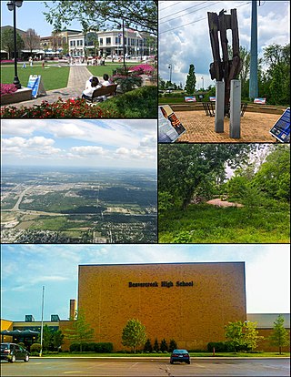
Beavercreek is the largest city in Greene County, Ohio, United States. The population was 46,549 at the 2020 census. Part of the Dayton metropolitan area, it is the second-largest suburb of Dayton.

<span class="mw-page-title-main">Bellbrook, Ohio</span> City in Ohio, United States

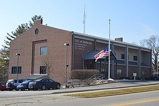
Bellbrook is a city in Greene County, Ohio, United States. The population was 7,317 at the 2020 census. It is part of the Dayton Metropolitan Statistical Area. It sits about 10.7 miles (17.2 km) southeast of Dayton.

<span class="mw-page-title-main">Xenia, Ohio</span> City in Ohio, United States

Xenia is a city in and the county seat of Greene County, Ohio, United States. Located in southwestern Ohio, it is 15 miles (24 km) east of Dayton and is part of the Dayton metropolitan area as well as the Miami Valley region. As of the 2020 census, the city had a population of 25,441. The city's name comes from the Greek word Xenia (ξενία), which means "hospitality".

<span class="mw-page-title-main">Addyston, Ohio</span> Village in Ohio, United States

Addyston is a village in Miami Township, Hamilton County, Ohio, United States. Located along the Ohio River, it is a western suburb of the neighboring city of Cincinnati. The population was 927 at the 2020 census.

<span class="mw-page-title-main">Clayton, Ohio</span> City in Ohio, United States

Clayton is a city in Montgomery County, Ohio, United States. The population was 13,310 at the 2020 census. A suburb of Dayton, it is part of the Dayton metropolitan area.

<span class="mw-page-title-main">Englewood, Ohio</span> City in Ohio, United States

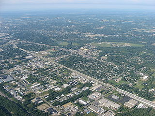
Englewood is a city in Montgomery County, Ohio, United States. The population was 13,463 at the 2020 census. A northern suburb of Dayton, it is part of the Dayton metropolitan area.

<span class="mw-page-title-main">Farmersville, Ohio</span> Village in Ohio, United States

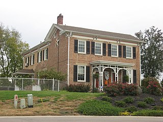
Farmersville is a village in Jackson Township, Montgomery County, Ohio, United States. The population was 975 at the 2020 census. It is part of the Dayton Metropolitan Statistical Area.

<span class="mw-page-title-main">Northridge, Montgomery County, Ohio</span> Unincorporated community and Census-designated place in Ohio, United States

Northridge is an unincorporated community in Harrison Township in Montgomery County, Ohio, United States. It was delineated as a census-designated place (CDP) for the 2000 census, at which time its population was 8,487. It is located directly north of the city of Dayton and is part of the Dayton Metropolitan Statistical Area.

<span class="mw-page-title-main">Riverside, Ohio</span> City in Ohio, United States

Riverside is a city in Montgomery County, Ohio, United States. The population was 24,474 at the 2020 census. A suburb of Dayton, it is part of the Dayton metropolitan area.

Shiloh is a census-designated place (CDP) in Harrison Township in Montgomery County, Ohio, United States. It was delineated as a census-designated place at the 2000 census, at which time its population was 11,272. It was not delineated as a CDP at the 2010 census. It is located directly north of the city of Dayton and is part of the Dayton Metropolitan Statistical Area.

<span class="mw-page-title-main">Woodbourne-Hyde Park, Ohio</span> Unincorporated community and census-designated place in Ohio, United States

Woodbourne-Hyde Park is an unincorporated area in Washington Township in Montgomery County, Ohio, United States. A Suburb of Dayton. It was delineated as a census-designated place (CDP) at the 2000 census, at which time its population was 7,910.

<span class="mw-page-title-main">Vanport Township, Pennsylvania</span> Township in Pennsylvania, United States

Vanport Township is a township that is located in Beaver County, Pennsylvania, United States, located along the Ohio River. The population was 1,289 at the time of the 2020 census. It is part of the Pittsburgh metropolitan area.

<span class="mw-page-title-main">Union, Ohio</span> City in Ohio, United States

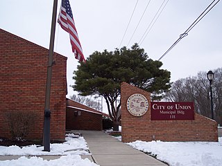
Union is a city in Montgomery and Miami Counties in the U.S. state of Ohio. The population was 6,859 at the time of the 2020 census. It is part of the Dayton Metropolitan Statistical Area.

<span class="mw-page-title-main">Carlisle, Ohio</span> City in Ohio, United States

Carlisle is a city in northwestern Warren and southern Montgomery counties in the southwestern part of the U.S. state of Ohio. The city is in Franklin Township, Warren County, Ohio and German Township, Montgomery County, Ohio.

<span class="mw-page-title-main">Springboro, Ohio</span> City in Ohio, United States

Springboro is a city in the U.S. state of Ohio. A suburb of Cincinnati and Dayton, it is located mostly in Warren County in Clearcreek and Franklin Townships; with a small portion in Miami Township in Montgomery County. The city is part of the Miami Valley. As of the 2020 census, the city had a population of 19,062.

References

  1. "ArcGIS REST Services Directory". United States Census Bureau. Retrieved September 20, 2022.
  2. 1 2 U.S. Geological Survey Geographic Names Information System: Trotwood, Ohio
  3. 1 2 3 "U.S. Census website". United States Census Bureau . Retrieved January 31, 2008.
  4. Overman, William Daniel (1958). Ohio Town Names. Akron, OH: Atlantic Press. p. 134.
  5. "Archived copy" (PDF). Archived from the original (PDF) on November 9, 2013. Retrieved November 9, 2013.{{cite web}}: CS1 maint: archived copy as title (link)
  6. Shively, Holly (May 29, 2019). "59 homes destroyed in Trotwood: 'We live in a trauma now'". Dayton Daily News. Dayton, Ohio: Cox Media Group. Retrieved May 30, 2019.
  7. "US Gazetteer files 2010". United States Census Bureau. Archived from the original on January 25, 2012. Retrieved January 6, 2013.
  8. Williams, Kevin (March 1, 2022). "Creeks, Once Overlooked, Are Now Seen as Assets for Urban Renewal". The New York Times. ISSN   0362-4331 . Retrieved March 3, 2022.
  9. "Archived copy" (PDF). Archived from the original (PDF) on November 9, 2013. Retrieved November 9, 2013.{{cite web}}: CS1 maint: archived copy as title (link)
  10. "Randolph Township Historical Society | Englewood, OH 45322". www.rths.org.
  11. "Population: Ohio" (PDF). 1930 US Census. U.S. Census Bureau. Retrieved November 28, 2013.
  12. "Number of Inhabitants: Ohio" (PDF). 18th Census of the United States. U.S. Census Bureau. 1960. Retrieved May 17, 2020.
  13. "Ohio: Population and Housing Unit Counts" (PDF). U.S. Census Bureau. Retrieved November 22, 2013.
  14. "Trotwood city, Ohio". census.gov. Retrieved July 6, 2022.
  15. "U.S. Census website". United States Census Bureau . Retrieved January 6, 2013.
  16. 2008 Dayton Hamvention - The Greatest Amateur Radio Convention in the World!
  17. "Roscoe Filburn's Farm". www.thefilburnfoundation.com.
  18. "Scrubs' Star "J.D." is from Trotwood |".
  19. "Locations". Dayton Metro Library. Retrieved March 1, 2018.