List of states and territories of the United States

Last updated

A map of the United States showing its 50 states, federal district and five inhabited territories. Alaska, Hawaii, and the territories are shown at different scales, and the Aleutian Islands and the uninhabited northwestern Hawaiian Islands are omitted from this map. Map of USA with state and territory names 2.png
A map of the United States showing its 50 states, federal district and five inhabited territories. Alaska, Hawaii, and the territories are shown at different scales, and the Aleutian Islands and the uninhabited northwestern Hawaiian Islands are omitted from this map.

The United States of America is a federal republic [1] consisting of 50 states, a federal district (Washington, D.C., the capital city of the United States), five major territories, and various minor islands. [2] [3] Both the states and the United States as a whole are each sovereign jurisdictions. [4] The Tenth Amendment to the United States Constitution allows states to exercise all powers of government not delegated to the federal government. Each state has its own constitution and government, and all states and their residents are represented in the federal Congress, a bicameral legislature consisting of the Senate and the House of Representatives. Each state is represented by two senators, while representatives are distributed among the states in proportion to the most recent constitutionally mandated decennial census. [5] Additionally, each state is entitled to select a number of electors to vote in the Electoral College, the body that elects the president of the United States, equal to the total of representatives and senators in Congress from that state. [6] The federal district does not have representatives in the Senate, but has a non-voting delegate in the House, and it is also entitled to electors in the Electoral College. Congress can admit more states, but it cannot create a new state from territory of an existing state or merge two or more states into one without the consent of all states involved, and each new state is admitted on an equal footing with the existing states. [7]

Contents

The United States has control over fourteen territories. Five of them (American Samoa, Guam, the Northern Mariana Islands, Puerto Rico, and the U.S. Virgin Islands) have a permanent, nonmilitary population, while nine of them (the United States Minor Outlying Islands) do not. With the exception of Navassa Island, Puerto Rico, and the U.S. Virgin Islands, which are located in the Caribbean, all territories are located in the Pacific Ocean. One territory, Palmyra Atoll, is considered to be incorporated, meaning the full body of the Constitution has been applied to it; the other territories are unincorporated, meaning the Constitution does not fully apply to them. Ten territories (the Minor Outlying Islands and American Samoa) are considered to be unorganized, meaning they have not had an organic act enacted by Congress; the four other territories are organized, meaning an organic act has been enacted by Congress. The five inhabited territories each have limited autonomy in addition to having territorial legislatures and governors, but residents cannot vote in federal elections, although all are represented by non-voting delegates in the House.

The largest state by population is California, with a population of 39,538,223 people, while the smallest is Wyoming, with a population of 576,851 people; the federal district has a larger population (689,545) than both Wyoming and Vermont. The largest state by area is Alaska, encompassing 665,384 square miles (1,723,340 km2), while the smallest is Rhode Island, encompassing 1,545 square miles (4,000 km2). The most recent states to be admitted, Alaska and Hawaii, were admitted in 1959. The largest territory by population is Puerto Rico, with a population of 3,285,874 people (larger than 21 states), while the smallest is the Northern Mariana Islands, with a population of 47,329 people. Puerto Rico is the largest territory by area, encompassing 5,325 square miles (13,790 km2); the smallest territory, Kingman Reef, encompasses only 0.005 square miles (0.013 km2).

States

Flag, name and
postal abbreviation [8]
CitiesRatification or
admission [upper-alpha 1]
Population
(2020) [10]
Total area [11] Reps.
CapitalLargest [12] mi2km2
Flag of Alabama.svg  Alabama AL Montgomery Huntsville Dec 14, 1819
5,024,279
52,420135,767
7
Flag of Alaska.svg  Alaska AK Juneau Anchorage Jan 3, 1959
733,391
665,3841,723,337
1
Flag of Arizona.svg  Arizona AZ Phoenix Feb 14, 1912
7,151,502
113,990295,234
9
Flag of Arkansas.svg  Arkansas AR Little Rock Jun 15, 1836
3,011,524
53,179137,732
4
Flag of California.svg  California CA Sacramento Los Angeles Sep 9, 1850
39,538,223
163,695423,967
52
Flag of Colorado.svg  Colorado CO Denver Aug 1, 1876
5,773,714
104,094269,601
8
Flag of Connecticut.svg  Connecticut CT Hartford Bridgeport Jan 9, 1788
3,605,944
5,54314,357
5
Flag of Delaware.svg  Delaware DE Dover Wilmington Dec 7, 1787
989,948
2,4896,446
1
Flag of Florida.svg  Florida FL Tallahassee Jacksonville Mar 3, 1845
21,538,187
65,758170,312
28
Flag of Georgia (U.S. state).svg  Georgia GA Atlanta Jan 2, 1788
10,711,908
59,425153,910
14
Flag of Hawaii.svg  Hawaii HI Honolulu Aug 21, 1959
1,455,271
10,93228,313
2
Flag of Idaho.svg  Idaho ID Boise Jul 3, 1890
1,839,106
83,569216,443
2
Flag of Illinois.svg  Illinois IL Springfield Chicago Dec 3, 1818
12,812,508
57,914149,995
17
Flag of Indiana.svg  Indiana IN Indianapolis Dec 11, 1816
6,785,528
36,42094,326
9
Flag of Iowa.svg  Iowa IA Des Moines Dec 28, 1846
3,190,369
56,273145,746
4
Flag of Kansas.svg  Kansas KS Topeka Wichita Jan 29, 1861
2,937,880
82,278213,100
4
Flag of Kentucky.svg  Kentucky [upper-alpha 2] KY Frankfort Louisville Jun 1, 1792
4,505,836
40,408104,656
6
Flag of Louisiana.svg  Louisiana LA Baton Rouge New Orleans Apr 30, 1812
4,657,757
52,378135,659
6
Flag of Maine.svg  Maine ME Augusta Portland Mar 15, 1820
1,362,359
35,38091,633
2
Flag of Maryland.svg  Maryland MD Annapolis Baltimore Apr 28, 1788
6,177,224
12,40632,131
8
Flag of Massachusetts.svg  Massachusetts [upper-alpha 2] MA Boston Feb 6, 1788
7,029,917
10,55427,336
9
Flag of Michigan.svg  Michigan MI Lansing Detroit Jan 26, 1837
10,077,331
96,714250,487
13
Flag of Minnesota.svg  Minnesota MN Saint Paul Minneapolis May 11, 1858
5,706,494
86,936225,163
8
Flag of Mississippi.svg  Mississippi MS Jackson Dec 10, 1817
2,961,279
48,432125,438
4
Flag of Missouri.svg  Missouri MO Jefferson City Kansas City Aug 10, 1821
6,154,913
69,707180,540
8
Flag of Montana.svg  Montana MT Helena Billings Nov 8, 1889
1,084,225
147,040380,831
2
Flag of Nebraska.svg  Nebraska NE Lincoln Omaha Mar 1, 1867
1,961,504
77,348200,330
3
Flag of Nevada.svg  Nevada NV Carson City Las Vegas Oct 31, 1864
3,104,614
110,572286,380
4
Flag of New Hampshire.svg  New Hampshire NH Concord Manchester Jun 21, 1788
1,377,529
9,34924,214
2
Flag of New Jersey.svg  New Jersey NJ Trenton Newark Dec 18, 1787
9,288,994
8,72322,591
12
Flag of New Mexico.svg  New Mexico NM Santa Fe Albuquerque Jan 6, 1912
2,117,522
121,590314,917
3
Flag of New York.svg  New York NY Albany New York City Jul 26, 1788
20,201,249
54,555141,297
26
Flag of North Carolina.svg  North Carolina NC Raleigh Charlotte Nov 21, 1789
10,439,388
53,819139,391
14
Flag of North Dakota.svg  North Dakota ND Bismarck Fargo Nov 2, 1889
779,094
70,698183,108
1
Flag of Ohio.svg  Ohio OH Columbus Mar 1, 1803
11,799,448
44,826116,098
15
Flag of Oklahoma.svg  Oklahoma OK Oklahoma City Nov 16, 1907
3,959,353
69,899181,037
5
Flag of Oregon.svg  Oregon OR Salem Portland Feb 14, 1859
4,237,256
98,379254,799
6
Flag of Pennsylvania.svg  Pennsylvania [upper-alpha 2] PA Harrisburg Philadelphia Dec 12, 1787
13,002,700
46,054119,280
17
Flag of Rhode Island.svg  Rhode Island RI Providence May 29, 1790
1,097,379
1,5454,001
2
Flag of South Carolina.svg  South Carolina SC Columbia Charleston May 23, 1788
5,118,425
32,02082,933
7
Flag of South Dakota.svg  South Dakota SD Pierre Sioux Falls Nov 2, 1889
886,667
77,116199,729
1
Flag of Tennessee.svg  Tennessee TN Nashville Jun 1, 1796
6,910,840
42,144109,153
9
Flag of Texas.svg  Texas TX Austin Houston Dec 29, 1845
29,145,505
268,596695,662
38
Flag of Utah.svg  Utah UT Salt Lake City Jan 4, 1896
3,271,616
84,897219,882
4
Flag of Vermont.svg  Vermont VT Montpelier Burlington Mar 4, 1791
643,077
9,61624,906
1
Flag of Virginia.svg  Virginia [upper-alpha 2] VA Richmond Virginia Beach Jun 25, 1788
8,631,393
42,775110,787
11
Flag of Washington.svg  Washington WA Olympia Seattle Nov 11, 1889
7,705,281
71,298184,661
10
Flag of West Virginia.svg  West Virginia WV Charleston Jun 20, 1863
1,793,716
24,23062,756
2
Flag of Wisconsin.svg  Wisconsin WI Madison Milwaukee May 29, 1848
5,893,718
65,496169,635
8
Flag of Wyoming.svg  Wyoming WY Cheyenne Jul 10, 1890
576,851
97,813253,335
1

Federal district

Name and
postal abbreviation [8]
EstablishedPopulation
[10]
Total area [11] Number
of Reps.
mi2km2
Flag of Washington, D.C.svg  District of Columbia DCJul 16, 1790 [13] 689,545681761 [upper-alpha 3]

Territories

.mw-parser-output .legend{page-break-inside:avoid;break-inside:avoid-column}.mw-parser-output .legend-color{display:inline-block;min-width:1.25em;height:1.25em;line-height:1.25;margin:1px 0;text-align:center;border:1px solid black;background-color:transparent;color:black}.mw-parser-output .legend-text{}
States and federal district
Inhabited territories
Uninhabited territories US insular areas 2.svg
  States and federal district     Inhabited territories     Uninhabited territories

Inhabited territories

Name and
postal abbreviation [8]
Capital Acquired
[15]
Territorial status [16] Population
[10] [17]
Total area [11] Reps.
mi2km2
Flag of American Samoa.svg American Samoa
AS Pago Pago [18] 1900
49,710
5811,505
Flag of Guam.svg Guam
GU Hagåtña [20] 1899
Unincorporated, organized
153,836
5711,478
Flag of the Northern Mariana Islands.svg Northern Mariana Islands
MP Saipan [21] 1986
Unincorporated, organized [upper-alpha 5]
47,329
1,9765,117
Flag of Puerto Rico.svg Puerto Rico
PR San Juan [22] 1899
Unincorporated, organized [upper-alpha 5]
3,285,874
5,32513,791
Flag of the United States Virgin Islands.svg U.S. Virgin Islands
VI Charlotte Amalie [23] 1917
Unincorporated, organized
87,146
7331,898

Uninhabited territories

Territories of the United States with no permanent population
Name Acquired [15] Territorial status [16] Land area [upper-alpha 7]
mi2km2
Baker Island [24] 18560.92.2
Howland Island [24] 1858
Unincorporated, unorganized
0.61.6
Jarvis Island [25] 1856
Unincorporated, unorganized
2.25.7
Johnston Atoll [26] 1859
Unincorporated, unorganized
12.6
Kingman Reef [27] 1860
Unincorporated, unorganized
0.0050.01
Midway Atoll [upper-alpha 8] [29] 1867
Unincorporated, unorganized
37.8
Navassa Island [30] 1858 [upper-alpha 9]
Unincorporated, unorganized
37.8
Palmyra Atoll [upper-alpha 10] [32] 1898
Incorporated, unorganized
1.53.9
Wake Island [upper-alpha 11] [33] 1899 [upper-alpha 12]
Unincorporated, unorganized
2.56.5

Disputed territories

Territories claimed but not administered by the United States
NameClaimed
[15]
Territorial status [35] AreaAdministered by [35] Also claimed by [35]
mi2km2
Bajo Nuevo Bank (Petrel Island) [15] 1869
Unincorporated, unorganized
(disputed sovereignty)
56145 [upper-alpha 13] [36] Flag of Colombia.svg  Colombia Flag of Jamaica.svg  Jamaica
Flag of Nicaragua.svg  Nicaragua
Serranilla Bank [15] 1880
Unincorporated, unorganized
(disputed sovereignty)
4631,200 [upper-alpha 14] [37] Flag of Colombia.svg  Colombia Flag of Honduras.svg  Honduras
Flag of Nicaragua.svg  Nicaragua

See also

Explanatory notes

  1. The original 13 states became sovereign in July 1776 upon agreeing to the United States Declaration of Independence, and each joined the first Union of states between 1777 and 1781, upon ratifying the Articles of Confederation. [9] These states are presented in the order in which each ratified the 1787 Constitution, thus joining the present federal Union of states. Subsequent states are listed in the order of their admission to the Union, and the date given is the official establishment date set by Act of Congress. For further details, see List of U.S. states by date of admission to the Union
  2. 1 2 3 4 Uses the term commonwealth rather than state in its full official name
  3. 1 2 3 4 5 Represented by a non-voting delegate in the House of Representatives. [14]
  4. Although not organized through a federal organic act or other explicit Congressional directive on governance, the people of American Samoa adopted a constitution in 1967, and then in 1977, elected territorial officials for the first time. [19]
  5. 1 2 Organized as a commonwealth.
  6. Represented by a non-voting resident commissioner in the House of Representatives. [14]
  7. Excluding lagoon
  8. Although there are no indigenous inhabitants, around 40 United States Fish and Wildlife Service staff and service contractors live on the island at any given time. [28]
  9. U.S. sovereignty is disputed by Haiti. [31]
  10. Although there are no indigenous inhabitants, between 4 and 20 Nature Conservancy, employees, United States Fish and Wildlife Service staff, and researchers live on the island at any given time. [28]
  11. Although there are no indigenous inhabitants, as of 2009, around 150 U.S. 150 U.S. military personnel and civilian contractors were living on the island, staffing the Wake Island Airfield and communications facilities. [33]
  12. U.S. sovereignty is disputed by the Republic of Marshall Islands. [34]
  13. This is the approximate figure for the land area of the bank, and does not include the surrounding territorial waters.
  14. This figure includes the total land area of the Serranilla Bank and the water area of its lagoon, but not the surrounding territorial waters.

Related Research Articles

<span class="mw-page-title-main">Federal jurisdiction (United States)</span> Legal scope of the powers of the U.S. federal government

Federal jurisdiction refers to the legal scope of the government's powers in the United States of America.

<span class="mw-page-title-main">Puerto Rico</span> Territory of the United States

Puerto Rico, officially the Commonwealth of Puerto Rico, is a Caribbean island, Commonwealth, and unincorporated territory of the United States. It is located in the northeast Caribbean Sea, approximately 1,000 miles (1,600 km) southeast of Miami, Florida, between the Dominican Republic and the U.S. Virgin Islands, and includes the eponymous main island and several smaller islands, such as Mona, Culebra, and Vieques. With roughly 3.2 million residents, it is divided into 78 municipalities, of which the most populous is the capital municipality of San Juan. Spanish and English are the official languages of the executive branch of government, though Spanish predominates.

<span class="mw-page-title-main">Contiguous United States</span> 48 states of the United States apart from Alaska and Hawaii

The contiguous United States consists of the 48 adjoining U.S. states and the District of Columbia of the United States of America in central North America. The term excludes the only two non-contiguous states, which are Alaska and Hawaii, and all other offshore insular areas, such as the U.S. territories of American Samoa, Guam, the Northern Mariana Islands, Puerto Rico, and the U.S. Virgin Islands. The colloquial term "Lower 48" is also used, especially in relation to Alaska.

A dependent territory, dependent area, or dependency is a territory that does not possess full political independence or sovereignty as a sovereign state and remains politically outside the controlling state's integral area. As such, a dependent territory includes a range of non-integrated not fully to non-independent territory types, from associated states to non-self-governing territories.

In the United States, a territory is any extent of region under the sovereign jurisdiction of the federal government of the United States, including all waters. The United States asserts sovereign rights for exploring, exploiting, conserving, and managing its territory. This extent of territory is all the area belonging to, and under the dominion of, the United States federal government for administrative and other purposes. The United States total territory includes a subset of political divisions.

<span class="mw-page-title-main">51st state</span> Proposals to admit a new state into the United States

The 51st state in American political discourse refers to the concept of granting statehood to one of the United States' territories, splitting one or more of the existing states up to form a new state, or granting statehood to the District of Columbia, thereby increasing the number of states in the Union from 50 to 51.

<span class="mw-page-title-main">Insular area</span> U.S. territory that is neither a U.S. state nor the District of Columbia

In the law of the United States, an insular area is a U.S.-associated jurisdiction that is not part of a U.S. state or the District of Columbia. This includes fourteen U.S. territories administered under U.S. sovereignty, as well as three sovereign states each with a Compact of Free Association with the United States. The term also may be used to refer to the previous status of the Swan Islands, Hawaii, Puerto Rico, and the Philippines, as well as the Trust Territory of the Pacific Islands when it existed.

<span class="mw-page-title-main">Territories of the United States</span>

Territories of the United States are sub-national administrative divisions overseen by the federal government of the United States. The various American territories differ from the U.S. states and Indian reservations as they are not sovereign entities. In contrast, each state has a sovereignty separate from that of the federal government and each federally recognized Native American tribe possesses limited tribal sovereignty as a "dependent sovereign nation." Territories are classified by incorporation and whether they have an "organized" government through an organic act passed by the Congress. American territories are under American sovereignty and, consequently, may be treated as part of the United States proper in some ways and not others. Unincorporated territories in particular are not considered to be integral parts of the United States, and the Constitution of the United States applies only partially in those territories.

The Insular Cases are a series of opinions by the Supreme Court of the United States in 1901 about the status of U.S. territories acquired in the Spanish–American War. Some scholars also include cases regarding territorial status decided up until 1914, and others include related cases as late as 1979. The term "insular" signifies that the territories were islands administered by the War Department's Bureau of Insular Affairs. Today, the categorizations and implications put forth by the Insular Cases still govern the United States' territories.

Commonwealth is a term used by two unincorporated territories of the United States in their full official names, which are the Northern Mariana Islands, whose full name is Commonwealth of the Northern Mariana Islands, and Puerto Rico, which is named Commonwealth of Puerto Rico in English and Estado Libre Asociado de Puerto Rico in Spanish, translating to "Free Associated State of Puerto Rico." The term was also used by the Philippines during most of its period under U.S. sovereignty, when it was officially called the Commonwealth of the Philippines.

<span class="mw-page-title-main">Office of Insular Affairs</span> Subsidiary of the Department of the Interior

The Office of Insular Affairs (OIA) is a unit of the United States Department of the Interior that oversees federal administration of several United States insular areas. It is the successor to the Bureau of Insular Affairs of the War Department, which administered certain territories from 1902 to 1939, and the Office of Territorial Affairs in the Interior Department, which was responsible for certain territories from the 1930s to the 1990s. The word "insular" comes from the Latin word insula ("island").

The United States territorial courts are tribunals established in territories of the United States by the United States Congress, pursuant to its power under Article Four of the United States Constitution, the Territorial Clause. Most United States territorial courts are defunct because the territories under their jurisdiction have become states or been retroceded.

<span class="mw-page-title-main">U.S. state</span> Constituent polity of the United States

In the United States, a state is a constituent political entity, of which there are 50. Bound together in a political union, each state holds governmental jurisdiction over a separate and defined geographic territory where it shares its sovereignty with the federal government. Due to this shared sovereignty, Americans are citizens both of the federal republic and of the state in which they reside. State citizenship and residency are flexible, and no government approval is required to move between states, except for persons restricted by certain types of court orders.

<span class="mw-page-title-main">District of Columbia and United States Territories quarters</span> Series of U.S. coins

The District of Columbia and United States Territories quarters were a series of six quarters minted by the United States Mint in 2009 to honor the District of Columbia and the unincorporated United States insular areas of Puerto Rico, Guam, the United States Virgin Islands, American Samoa, and the Northern Mariana Islands. The islands commonly grouped together as the United States Minor Outlying Islands were not featured, as the law defined the word "territory" as being limited to the areas mentioned above. They followed the completion of the 50 State Quarters Program. The coins used the same George Washington obverse as with the quarters of the previous 10 years. The reverse of the quarters featured a design selected by the Mint depicting the federal district and each territory. Unlike on the 50 State quarters, the motto "E Pluribus Unum" preceded and was the same size as the mint date on the reverse.

<span class="mw-page-title-main">Puerto Rico statehood movement</span> Movement to grant Puerto Rico U.S. statehood

The Puerto Rico statehood movement aims to make Puerto Rico a state of the United States. Puerto Rico is an unincorporated territorial possession of the United States acquired in 1898 following the Spanish–American War, making it "the oldest colony in the modern world". As of 2023, the population of Puerto Rico is 3.2 million, around half the average state population and higher than that of 19 U.S. states. Statehood is one of several competing options for the future political status of Puerto Rico, including: maintaining its current status, becoming fully independent, or becoming a freely associated state. Puerto Rico has held six referendums on the topic. These are non-binding, as the power to grant statehood lies with the US Congress. The most recent referendum was in November 2020, with a majority (52.52%) of those who voted opting for statehood.

<span class="mw-page-title-main">Political status of Puerto Rico</span> Unincorporated territory of the United States

The political status of Puerto Rico is that of an unincorporated territory of the United States officially known as the Commonwealth of Puerto Rico. As such, the island of Puerto Rico is neither a sovereign nation nor a U.S. state.

<span class="mw-page-title-main">American Samoan citizenship and nationality</span> Application of United States nationality and citizenship in American Samoa

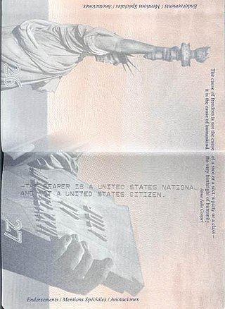
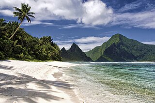
American Samoa consists of a group of two coral atolls and five volcanic islands in the South Pacific Ocean of Oceania. The first permanent European settlement was founded in 1830 by British missionaries, who were followed by explorers from the United States, in 1839, and German traders in 1845. Based upon the Tripartite Convention of 1899, the United States, Great Britain, and Germany agreed to partition the islands into German Samoa and American Samoa. Though the territory was ceded to the United States in a series of transactions in 1900, 1904, and 1925, Congress did not formally confirm its acquisition until 1929. American Samoans are non-citizen nationals of the United States. Non-citizen nationals do not have full protection of their rights, though they may reside in the United States and gain entry without a visa. Territorial citizens do not have the ability for full participation in national politics and American Samoans cannot serve as officers in the US military or in many federal jobs, are unable to bear arms, vote in local elections, or hold public office or civil-service positions even when residing in a US state. Nationality is the legal means in which inhabitants acquire formal membership in a nation without regard to its governance type. Citizenship is the relationship between the government and the governed, the rights and obligations that each owes the other, once one has become a member of a nation.

References

  1. Onuf, Peter S. (1983). The Origins of the Federal Republic: Jurisdictional Controversies in the United States, 1775–1787 . Philadelphia: University of Pennsylvania Press. ISBN   978-0-8122-1167-2.
  2. "Common Core Document of the United States of America: Submitted With the Fourth Periodic Report of the United States of America to the United Nations Committee on Human Rights concerning the International Covenant on Civil and Political Rights". U.S. Department of State, via The Office of Website Management, Bureau of Public Affairs. Retrieved July 9, 2017.
  3. "U.S. Insular Areas: application of the U.S. Constitution" (PDF). Government Accountability Office. November 1997. Archived (PDF) from the original on November 3, 2013. Retrieved July 10, 2013.
  4. Radan, 2007, p. 12
  5. Burnett, Kristin D. "Congressional Apportionment (2010 Census Briefs C2010BR-08)" (PDF). U.S. Department of Commerce, Economics and Statistics Administration. Archived from the original (PDF) on November 19, 2011.
  6. Elhauge, Einer R. "Essays on Article II: Presidential Electors". The Heritage Foundation. Archived from the original on July 24, 2017. Retrieved December 29, 2015.
  7. "Doctrine of the Equality of States". Justia Law. Archived from the original on October 19, 2012. Retrieved June 16, 2017.
  8. 1 2 3 "Appendix B: Two–Letter State and possession Abbreviations". Postal Addressing Standards. Washington, D.C.: United States Postal Service. May 2015. Archived from the original on March 5, 2018. Retrieved March 3, 2018.
  9. Jensen, Merrill (1959). The Articles of Confederation: An Interpretation of the Social-Constitutional History of the American Revolution, 1774–1781. University of Wisconsin Press. pp. xi, 184. ISBN   978-0-299-00204-6.
  10. 1 2 3 "Resident Population for the 50 States, the District of Columbia, and Puerto Rico: 2020 Census" (PDF). U.S. Census Bureau. Archived (PDF) from the original on December 7, 2023.
  11. 1 2 3 "State Area Measurements and Internal Point Coordinates". Washington, D.C.: U.S. Census Bureau. Archived from the original on March 16, 2018. Retrieved March 3, 2018. ... provides land, water and total area measurements for the 50 states, the District of Columbia, Puerto Rico and the Island Areas. The area measurements were derived from the Census Bureau's Master Address File/Topologically Integrated Geographic Encoding and Referencing (MAF/TIGER®) database. The boundaries of the states and equivalent areas are as of January 1, 2010. The land and water areas, ... reflect base feature updates made in the MAF/TIGER® database through August, 2010.
  12. "State and Local Government Finances and Employment" (PDF). United States Census Bureau. 2012. p. 284. Archived from the original (PDF) on October 17, 2011. Retrieved July 8, 2013.
  13. "The History of Washington, DC". Destination DC. March 15, 2016. Archived from the original on March 6, 2018. Retrieved March 3, 2018.
  14. 1 2 "Directory of Representatives". Washington, D.C.: U.S. House of Representatives. Archived from the original on March 5, 2018. Retrieved March 5, 2018.
  15. 1 2 3 4 5 "Acquisition Process of Insular Areas". Office of Insular Affairs. Archived from the original on April 14, 2012. Retrieved July 9, 2013.
  16. 1 2 "Definitions of Insular Area Political Organizations". Washington, D.C.: U.S. Department of the Interior. June 12, 2015. Archived from the original on July 13, 2018. Retrieved March 1, 2018.
  17. 2020 Population of U.S. Island Areas Just Under 339,000, U.S. Census Bureau, October 28, 2021.
  18. "American Samoa". The World Factbook . Central Intelligence Agency . Retrieved July 9, 2013.
  19. "Islands We Serve: American Samoa". Washington, D.C.: U.S. Department of the Interior. June 11, 2015. Archived from the original on March 9, 2018. Retrieved March 1, 2018.
  20. "Guam". The World Factbook. Central Intelligence Agency. Retrieved July 9, 2013.
  21. "Northern Mariana Islands". The World Factbook. Central Intelligence Agency. Retrieved July 9, 2013.
  22. "Puerto Rico". The World Factbook. Central Intelligence Agency. Retrieved July 9, 2013.
  23. "Virgin Islands". The World Factbook. Retrieved July 9, 2013.
  24. 1 2 "Baker Island". Office of Insular Affairs. Archived from the original on April 19, 2012. Retrieved July 9, 2013.
  25. "Jarvis Island". Office of Insular Affairs. Archived from the original on February 7, 2012. Retrieved July 9, 2013.
  26. "Johnston Island". Office of Insular Affairs. Archived from the original on March 14, 2012. Retrieved July 9, 2013.
  27. "Kingman Reef National Wildlife Refuge". United States Fish and Wildlife Service. Archived from the original on May 16, 2013. Retrieved July 9, 2013.
  28. 1 2 "United States Pacific Islands Wildlife Refuges". The World Factbook. Central Intelligence Agency. Retrieved October 10, 2014.
  29. "Midway Atoll". Office of Insular Affairs. Archived from the original on February 4, 2012. Retrieved July 9, 2013.
  30. "Navassa Island". Washington, D.C.: U.S. Department of the Interior. June 12, 2015. Archived from the original on August 15, 2016. Retrieved March 3, 2018.
  31. Colon, Yves (September 25, 1998). "U.S., Haiti Squabble Over Control of Tiny Island". Miami Herald . Webster University. Archived from the original on August 30, 2016. Retrieved November 25, 2016.
  32. "Palmyra Atoll". Office of Insular Affairs. Archived from the original on January 11, 2012. Retrieved July 9, 2013.
  33. 1 2 "Wake Island". The World Factbook. Central Intelligence Agency. Retrieved October 10, 2014.
  34. Earnshaw, Karen (December 17, 2016). "Enen Kio (a.k.a. Wake Island): Island of the kio flower". Marshall Islands Guide. Majuro, Republic of the Marshall Islands. Archived from the original on April 1, 2018. Retrieved March 4, 2018.
  35. 1 2 3 Lewis, Martin W. (March 21, 2011). "When Is an Island Not An Island? Caribbean Maritime Disputes". GeoCurrents. Archived from the original on April 22, 2017. Retrieved June 16, 2017.
  36. "US Minor Outlying Islands – Bajo Nuevo Bank". Geocaching. June 6, 2017. Archived from the original on July 11, 2015. Retrieved July 10, 2015.
  37. "Cayo Serranilla" (in Spanish). Eco Fiwi. Archived from the original on July 31, 2017. Retrieved June 16, 2017.