Forest cover by state and territory in the United States

Last updated

Map of wood-filled areas in the United States, circa 2000 Aboveground Woody Biomass in the United States 2011.jpg
Map of wood-filled areas in the United States, circa 2000

In the United States, the forest cover by state and territory is estimated from tree-attributes using the basic statistics reported by the Forest Inventory and Analysis (FIA) program of the Forest Service. [2] Tree volumes and weights are not directly measured in the field, but computed from other variables that can be measured. [3] [4]

Contents

This is only the total amount of timberland. Actual forest cover for each state may be significantly higher. [5] [1]

List by state, district, or territory

RankState, district
or territory
Percent
forest
(2016) [2]
[note 1]
1Flag of Maine.svg  Maine 89.46%
2Flag of New Hampshire.svg  New Hampshire 84.32%
3Flag of American Samoa.svg  American Samoa 80.84%
4Flag of the Northern Mariana Islands.svg  Northern Mariana Islands 80.37%
5Flag of West Virginia.svg  West Virginia 79.01%
6Flag of Vermont.svg  Vermont 77.811%
7Flag of Alabama.svg  Alabama 70.57%
8Flag of South Carolina.svg  South Carolina 68.19%
9Flag of Georgia (U.S. state).svg  Georgia 67.28%
10Flag of Mississippi.svg  Mississippi 65.07%
11Flag of Virginia.svg  Virginia 62.93%
12Flag of New York.svg  New York 62.88%
13Flag of Massachusetts.svg  Massachusetts 60.57%
14Flag of North Carolina.svg  North Carolina 59.73%
15Flag of Pennsylvania.svg  Pennsylvania 58.60%
16 Flag of the United States Virgin Islands.svg Virgin Islands (U.S.) 57.16%
17Flag of Arkansas.svg  Arkansas 56.31%
18Flag of Puerto Rico.svg  Puerto Rico 55.62%
19Flag of Michigan.svg  Michigan 55.62%
20Flag of Connecticut.svg  Connecticut 55.24%
21Flag of Rhode Island.svg  Rhode Island 54.38%
22Flag of Louisiana.svg  Louisiana 53.20%
23Flag of Tennessee.svg  Tennessee 52.83%
24Flag of Guam.svg  Guam 52.82%
25Flag of Washington.svg  Washington 52.74%
26Flag of Florida.svg  Florida 50.68%
27Flag of Kentucky.svg  Kentucky 49.35%
28Flag of Wisconsin.svg  Wisconsin 48.98%
29Flag of Oregon.svg  Oregon 48.51%
30Flag of Hawaii.svg  Hawaii 42.53%
31Flag of New Jersey.svg  New Jersey 41.72%
32Flag of Idaho.svg  Idaho 40.55%
33Flag of Maryland.svg  Maryland 39.36%
34Flag of Texas.svg  Texas 37.33%
35Flag of Missouri.svg  Missouri 35.16%
36Flag of Alaska.svg  Alaska 35.16%
37Flag of Utah.svg  Utah 34.48%
38Flag of Colorado.svg  Colorado 34.42%
39Flag of Minnesota.svg  Minnesota 34.08%
40Flag of the District of Columbia.svg  District of Columbia 33.90% [6]
41Flag of California.svg  California 32.71%
42Flag of New Mexico.svg  New Mexico 31.99%
43Flag of Ohio.svg  Ohio 30.92%
44Flag of Oklahoma.svg  Oklahoma 28.80%
45Flag of Montana.svg  Montana 27.45%
46Flag of Delaware.svg  Delaware 27.26%
47Flag of Arizona.svg  Arizona 25.64%
48Flag of Indiana.svg  Indiana 21.06%
49Flag of Wyoming.svg  Wyoming 18.42%
50Flag of Nevada.svg  Nevada 15.89%
51Flag of Illinois.svg  Illinois 13.64%
52Flag of Iowa.svg  Iowa 8.43%
53Flag of Kansas.svg  Kansas 4.78%
54Flag of South Dakota.svg  South Dakota 3.93%
55Flag of Nebraska.svg  Nebraska 3.20%
56Flag of North Dakota.svg  North Dakota 1.72%
Flag of the United States.svg U.S. Minor Outlying Islands
[note 2]
No data

List by region

RankRegionPercent
forest
(2016) [2]
1 U.S. territories [note 3] 56.74%
2 Southern region [note 4] 50.13%
3 Pacific Northwest region [note 5] 37.52%
4 Northern region [note 6] 30.04%
5 Interior West region [note 7] 28.14%
Total36.21%

See also

Related Research Articles

In the United States, a territory is any extent of region under the sovereign jurisdiction of the federal government of the United States, including all waters. The United States asserts sovereign rights for exploring, exploiting, conserving, and managing its territory. This extent of territory is all the area belonging to, and under the dominion of, the United States federal government for administrative and other purposes. The United States total territory includes a subset of political divisions.

<span class="mw-page-title-main">Lists of hospitals in the United States</span>

This article contains links to lists of hospitals in the United States, including U.S. States, the national capital of Washington, D.C., insular areas, and outlying islands. Links to more detailed state lists are shown.

In 45 of the 50 states of the United States, the county is used for the level of local government immediately below the state itself. Louisiana uses parishes, and Alaska uses boroughs. In Connecticut, Massachusetts, and Rhode Island, some or all counties within states have no governments of their own; the counties continue to exist as legal entities, however, and are used by states for some administrative functions and by the United States Census bureau for statistical analysis. There are 3,242 counties and county equivalent administrative units in total, including the District of Columbia and 100 county-equivalents in the U.S. territories.

<span class="mw-page-title-main">Insular area</span> U.S. territory that is neither a U.S. state nor the District of Columbia

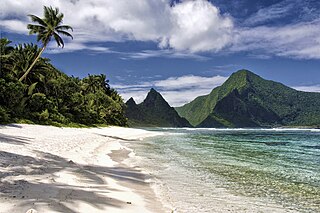
In the law of the United States, an insular area is a U.S.-associated jurisdiction that is not part of the 50 states or the District of Columbia. This includes fourteen U.S. territories administered under U.S. sovereignty, as well as three sovereign states each with a Compact of Free Association with the United States. The term also may be used to refer to the previous status of the Philippine Islands and the Trust Territory of the Pacific Islands when it existed.

<span class="mw-page-title-main">Territories of the United States</span> Overview of U.S. territories

Territories of the United States are sub-national administrative divisions overseen by the federal government of the United States. The various American territories differ from the U.S. states and Indian reservations as they are not sovereign entities. In contrast, each state has a sovereignty separate from that of the federal government and each federally recognized Native American tribe possesses limited tribal sovereignty as a "dependent sovereign nation". Territories are classified by incorporation and whether they have an "organized" government through an organic act passed by the Congress. American territories are under American sovereignty and, consequently, may be treated as part of the United States proper in some ways and not others. Unincorporated territories in particular are not considered to be integral parts of the United States, and the Constitution of the United States applies only partially in those territories.

<span class="mw-page-title-main">Lists of hospitals in Oceania</span>

This is a list of hospitals in Oceania for each sovereign state, associated states of New Zealand, and dependencies, and territories. Links to lists of hospitals in countries are used when there are more than a few hospitals in the country. Oceania has an area of 8,525,989 km2 and population of 41,570,842 (2018). The World Health Organization surveys of healthcare in smaller countries are used to identify hospitals in smaller countries.

<span class="mw-page-title-main">Office of Insular Affairs</span> Subsidiary of the Department of the Interior

The Office of Insular Affairs (OIA) is a unit of the United States Department of the Interior that oversees federal administration of several United States insular areas. It is the successor to the Bureau of Insular Affairs of the War Department, which administered certain territories from 1902 to 1939, and the Office of Territorial Affairs in the Interior Department, which was responsible for certain territories from the 1930s to the 1990s. The word "insular" comes from the Latin word insula ("island").

<span class="mw-page-title-main">Pacific coast</span> Part of a nations coast bordering the Pacific Ocean

Pacific coast may be used to reference any coastline that borders the Pacific Ocean.

<span class="mw-page-title-main">Asia-Pacific</span> Geographical and geopolitical region in Asia and Oceania

Asia-Pacific (APAC) is the part of the world near the western Pacific Ocean. The Asia-Pacific region varies in area depending on the context, but it often includes countries in East Asia, Southeast Asia, and Oceania that border the Pacific Ocean. South Asia, Mongolia, Myanmar, and the Russian Far East are generally included in a wider Asia-Pacific region.

<span class="mw-page-title-main">Forests of the United States</span> Overview of the forests of the United States

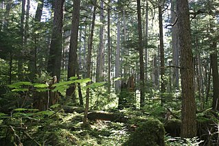
It has been estimated that before European settlement, forests in the United States mainland, covered nearly 1 billion acres (4,000,000 km2). Since the mid-1600s, about 300 million acres (1,200,000 km2) of forest have been cleared, primarily for agriculture during the 19th century.

<span class="mw-page-title-main">Outline of Oceania</span> Overview of and topical guide to Oceania

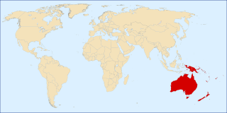
The following outline is provided as an overview and topical guide to Oceania.

A customs territory is a geographic territory with uniform customs regulations and there are no internal customs or similar taxes within the territory. Customs territories may fall into several types:

References

  1. 1 2 "Forest Inventory and Analysis National Program - FIA Library". www.fia.fs.fed.us. Retrieved 21 April 2018.
  2. 1 2 3 "Forest Inventory and Analysis Fiscal Year 2016 Business Report" (PDF). United States Department of Agriculture. Retrieved 25 July 2022.
  3. "FIA Volume Calculations" (PDF). fs.fed.us. Retrieved 21 April 2018.
  4. Bechtold, William A.; Patterson, Paul L. (2005). Bechtold, William A; Patterson, Paul L (eds.). "The enhanced forest inventory and analysis program - national sampling design and estimation procedures". Gen. Tech. Rep. SRS-80. Asheville, NC: U.S. Department of Agriculture, Forest Service, Southern Research Station. 85 p. doi:10.2737/SRS-GTR-80. hdl: 2027/umn.31951d02988399b . Retrieved 25 July 2022.
  5. "United States Map: Percent of Area with Forest, 2002 | The Federal Reserve Bank of Minneapolis". fedgazette. Archived from the original on January 7, 2009.
  6. Nowak, David J.; Greenfield, Eric J. (1 May 2018). "Declining urban and community tree cover in the United States". Urban Forestry & Urban Greening. 32: 32–55. doi: 10.1016/j.ufug.2018.03.006 . ISSN   1618-8667 . Retrieved 25 July 2022.
  7. "Study shows 5,000 percent increase in native trees on rat-free Palmyra Atoll". phys.org. Retrieved 25 July 2022.

Notes

  1. The forest percent is the percent of land that is forested (excluding bodies of water). Data for Puerto Rico, the Virgin Islands, and Guam is from 2013. Data for the Northern Mariana Islands is from 2015. Data for American Samoa is from 2012. Data for the national capital of Washington, D.C. is from 2018.
  2. There is a forest on Palmyra Atoll, [7] but there is no information about what percentage of land the forest covers.
  3. The U.S. territories are American Samoa, Guam, Northern Mariana Islands, Puerto Rico and U.S. Virgin Islands. The U.S. Minor Outlying Islands are not counted.
  4. The FIA defines the Southern region of the U.S. as Alabama, Arkansas, Florida, Georgia, Kentucky, Louisiana, Mississippi, North Carolina, Oklahoma, South Carolina, Tennessee, Texas, and Virginia.
  5. The FIA defines the Pacific Northwest region as Alaska, California, Hawaii, Oregon, and Washington.
  6. The FIA defines the Northern region of the U.S. as Connecticut, Delaware, Illinois, Indiana, Iowa, Kansas, Maine, Maryland, Massachusetts, Michigan, Minnesota, Missouri, Nebraska, New Hampshire, New Jersey, New York, North Dakota, Ohio, Pennsylvania, Rhode Island, South Dakota, Vermont, West Virginia and Wisconsin. The District of Columbia is not counted.
  7. The FIA defines the Interior West region of the U.S. as Arizona, Colorado, Idaho, Montana, Nevada, New Mexico, Utah, and Wyoming.

Further reading