The forest cover in Russia by federal subject as published by the Unified Interdepartmental Statistical Information System. As of 2021 49.4% of Russia is covered in trees.[2]
Contents


The forest cover in Russia by federal subject as published by the Unified Interdepartmental Statistical Information System. As of 2021 49.4% of Russia is covered in trees.[2]

A forest is an area of land dominated by trees. Hundreds of definitions of forest are used throughout the world, incorporating factors such as tree density, tree height, land use, legal standing, and ecological function. The United Nations' Food and Agriculture Organization (FAO) defines a forest as, "Land spanning more than 0.5 hectares with trees higher than 5 meters and a canopy cover of more than 10 percent, or trees able to reach these thresholds in situ. It does not include land that is predominantly under agricultural or urban use." Using this definition, Global Forest Resources Assessment 2020 found that forests covered 4.06 billion hectares, or approximately 31 percent of the world's land area in 2020.

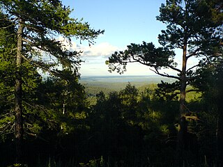
Taiga, generally referred to in North America as a boreal forest or snow forest, is a biome characterized by coniferous forests consisting mostly of pines, spruces, and larches.

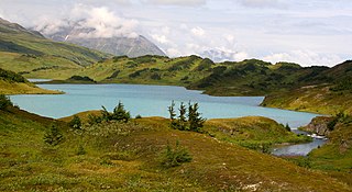
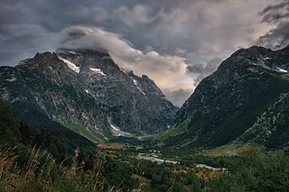
The Caucasus Mountains is a mountain range at the intersection of Asia and Europe. Stretching between the Black Sea and the Caspian Sea, it is surrounded by the Caucasus region and is home to Mount Elbrus, the highest peak in Europe at 5,642 metres (18,510 ft) above sea level.

The Komi Republic, sometimes simply referred to as Komi, is a federal subject of Russia in Eastern Europe. Its capital is the city of Syktyvkar. The population of the republic, as of the 2010 Census was 901,189.
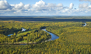
The West Siberian Plain is a large plain that occupies the western portion of Siberia, between the Ural Mountains in the west and the Yenisei River in the east, and by the Altay Mountains on the southeast. Much of the plain is poorly drained and consists of some of the world's largest swamps and floodplains. Important cities include Omsk, Novosibirsk, Tomsk and Chelyabinsk.
The Chugach National Forest is a 6,908,540-acre (27,958 km2) United States National Forest in south central Alaska. Covering portions of Prince William Sound, the Kenai Peninsula and the Copper River Delta, it was formed in 1907 from part of a larger forest reserve. The Chugach includes extensive shorelines, glaciers, forests and rivers, much of which is untouched by roads or trails. It hosts numerous bird, mammal and marine species, including extensive shorebird habitat and a bald eagle population larger than the contiguous 48 states combined. Human industry in the forest includes extensive tourism and some mining and oil and gas operations.
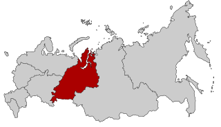
Ural is a geographical region located around the Ural Mountains, between the East European and West Siberian plains. It is considered a part of Eurasian Steppe, extending approximately from the North to the South; from the Arctic Ocean to the end of Ural River near Orsk city. The border between Europe and Asia runs along the Eastern side of the Ural Mountains. Ural mostly lies within Russia but also includes a small part of Northwestern Kazakhstan. This is a historical, not an official entity, with borders overlapping its Western Volga and Eastern Siberia neighboring regions. At some point in the past, parts of the currently existing Ural region were considered a gateway to Siberia, or even Siberia itself, and were combined with the Volga administrative the divisions. Today, there are two official namesake entities; the Ural Federal District and the Ural economic region. While the latter follows the historical borders, the former is a political product; the District omits Western Ural and includes Western Siberia instead.
The Russian forestry industry is a set of Russian industries related to wood harvesting and processing. As one of the oldest sectors in the country's economy, Russia's timber industry continues to bring in about $20 billion per year. Russia has more than a fifth of the world's forests, making it the largest forest country in the world. According to data for 2015, the total forest area has exceeded 885 million hectares, representing 45% of the total area of the country. The stock of wood in the area was 82 billion cubic meters.

Vodlozersky National Park is a national park in the north of Russia, located in Onezhsky District of Arkhangelsk Oblast and Pudozhsky District in the Republic of Karelia. It was established April 20, 1991. Since 2001, the National Park has the status of a UNESCO Biosphere Reserve. The national park was created to protect coniferous forests (taiga) of Northern Russia.

Climate change in Russia has serious effects on Russia's climate, including average temperatures and precipitation, as well as permafrost melting, more frequent wildfires, flooding and heatwaves. Changes may affect inland flash floods, more frequent coastal flooding and increased erosion reduced snow cover and glacier melting, and may ultimately lead to species losses and changes in ecosystem functioning.
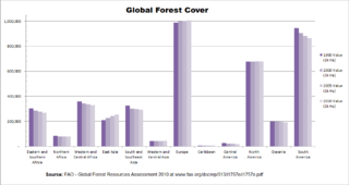
Rates and causes of deforestation vary from region to region around the world. In 2009, 2/3 of the world's forests were in just 10 countries: 1) Russia, 2) Brazil, 3) Canada, 4) United States, 5) China, 6) Australia, 7) Democratic Republic of the Congo, 8) Indonesia, 9) India, and 10) Peru.
The wildlife of Russia inhabits terrain that extends across 12 time zones and from the tundra region in the far north to the Caucasus Mountains and prairies in the south, including temperate forests which cover 70% of the country's territory. Russia's forests comprise 22% of the forest in the world as well as 33% of all temperate forest in the world.

Meshchyorsky National Park covers extensive wetlands and pine/birch woodlands in the Meshchera Lowlands on the East European Plain in the northern section of Ryazan Oblast, Russia, about 120 km east of Moscow. The wetland habitat provides for extremely rich biodiversity among the plants and animals. "Meshchersky" (Мещёрский) National Park is not to be confused with "Meshchyora" (Мещёра) National Park, which is just to the north, over the border in Vladimir Oblast. The park protects a section of the Pra River, Lake Beloye, and associated wetlands and forests. About 54% of the park territory is used and managed for agricultural purposes by local communities.

Nechkinsky National Park is an important biological and cultural reserve of Udmurtia, situated in the middle valley of the Kama River, its tributary the Siva River, and the coastal part of the Votkinsk reservoir. This places Nechkinsky on the western side of the central Ural Mountains. The territory is mostly forest and river floodplains, with a number of ancient archaeological sites on the grounds. It is near the city of Izhevsk.
Teberda Nature Reserve is a Russian 'zapovednik' located on the northern slopes of the western section of the Caucasus Mountains. It is the most visited nature reserve in the Russian Federation, with over 200,000 recorded in 2010. Included in the reserve are a popular tourist complex ("Dombay") and resorts in the surrounding areas. The terrain show extremes in variation: 31.7% forests, 20% meadows, 8.5% glaciers, 38.4% rock and scree, 0.7% water. The reserve is divided into two sections - the Tebardinsky to the east, and the Arkhyz to the west. The two sections were connected in 2010 by a "biosphere polygon", the Caucasus State Nature Reserve. The two sectors are situated in the Karachayevsky District of the Karachay-Cherkess Republic. It is part of a UNESCO World Biosphere Reserve. The reserve was created in 1936, and covers an area of 84,996 ha (328.17 sq mi).
Ilmen Nature Reserve is a Russian 'zapovednik' that was created by decree of Vladimir Lenin, in 1920 as a mineralogical nature reserve. It is the site of deposits of many rare-earth minerals - 16 minerals were first discovered here, including Ilmenite, Monazite, Cancrinite, and Samarskite-(Y). There have been over 400 mines in the area over the years. The Reserve's geological museum is one of the largest in Russia. The forest cover is pine and larch forest on low hills of the Ilmensky Mountains and foothill ridges on east side of the south Ural Mountains. The reserve is situated just north and east of the city of Miass, in the Chebarkulsky District of Chelyabinsk Oblast. It is also 20 kkm east of Taganay National Park and 75 km west of Chelyabinsk.

Khanka Nature Reserve is a Russian 'zapovednik' that covers portions of the shore and waters of Lake Khanka, the largest freshwater lake in the Russian Far East. It is an important area for nesting and migrating waterfowl and other birds. The reserve is divided into five distinct sectors on the southern and eastern shores of the lake. The reserve is situated in the Spassky District, in the southwest of Primorsky Krai. It was formally established in 1990, and covers an area of 437 km2 (169 sq mi). It is part of a UNESCO Biosphere Reserve.
The Okhotsk-Manchurian taiga ecoregion is an area of coniferous forests in the Russian Far East, covering the Amur River delta, the west coast of the Okhotsk Sea, and the rugged extension of the northern Sikhote-Alin Mountains that run southwest-to-northeast through the Primorsky and Khabarovsk regions. It is the southernmost taiga forest in Eurasia. The ecoregion is distinguished from surrounding ecoregions by the slightly warmer climate due to the maritime influence and the shield of the mountains to the west, and by the mixing of flora and fauna species from Okhotsk-Kamchatka communities to the north and Manchurian species from the south. The forest at lower altitudes is "light taiga", and "dark taiga" at higher altitudes.
Forest cover is the amount of land area that is covered by forest. It may be measured as relative or absolute. Around a third of the world's surface is covered with forest, with closed-canopy forest accounting for 4 - 5 billion hectares of land.

The Ussuri broadleaf and mixed forests ecoregion covers a mountainous areas above the lower Amur River and Ussuri River in Primorsky Krai and Khabarovsk Krai in the Russian Far East. The ecoregion is in the Palearctic realm, with a Humid Continental climate. It covers 187,357 km2 (72,339 sq mi).
a. ^ Not recognized internationally as a part of Russia.