
Ust-Orda Buryat Okrug, or Ust-Orda Buryatia, is an administrative division of Irkutsk Oblast, Russia. It was a federal subject of Russia from 1993 to January 1, 2008, when it merged with Irkutsk Oblast. It also had autonomous okrug status from September 26, 1937 to 1993. Prior to the merger, it was called Ust-Orda Buryat Autonomous Okrug. It is one of the two Buryat okrugs in Russia, the other one is Agin-Buryat Okrug in Zabaykalsky Krai.

Agin-Buryat Okrug, or Aga Buryatia, is an administrative division of Zabaykalsky Krai, Russia. It was a federal subject of Russia until it merged with Chita Oblast to form Zabaykalsky Krai on March 1, 2008. Prior to the merger, it was called Agin-Buryat Autonomous Okrug. Its administrative center is the urban-type settlement of Aginskoye. It is one of the two Buryat okrugs in Russia, the other one is Ust-Orda Buryat Okrug of Irkutsk Oblast.
Ust-Ordynsky is a rural locality and the administrative center of Ekhirit-Bulagatsky District of Ust-Orda Buryat Okrug in Irkutsk Oblast, Russia, as well as the administrative center of Ust-Orda Buryat Okrug. It is located on the right bank of the Kuda River 62 kilometers (39 mi) northeast of Irkutsk. Population: 14,891 (2010 Census); 14,335 (2002 Census); 13,030 (1989 Census).

Perm Krai is a federal subject of Russia, located in Eastern Europe. Its administrative center is Perm. The population of the krai was 2,532,405.

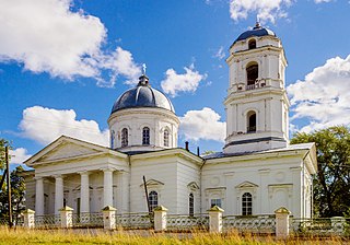
Okhansk is a town and the administrative center of Okhansky District in Perm Krai, Russia, located on the right bank of the Kama River, 119 kilometers (74 mi) southwest of Perm, the administrative center of the krai. Population: 7,250 (2010 Census); 7,994 (2002 Census); 8,414 (1989 Census).

Zabaykalsky Krai is a federal subject of Russia, located in the Russian Far East. Its administrative center is Chita. As of the 2010 Census, the population was 1,107,107.

Kochyovsky District is an administrative district (raion) of Komi-Permyak Okrug of Perm Krai, Russia; one of the thirty-three in the krai. Municipally, it is incorporated as Kochyovsky Municipal District. It is located in the northwest of the krai. The area of the district is 2,700 square kilometers (1,000 sq mi). Its administrative center is the rural locality of Kochyovo. Population: 11,167 (2010 Census); 12,856 (2002 Census); 14,188 (1989 Census). The population of Kochyovo accounts for 31.4% of the district's total population.

Kosinsky District is an administrative district (raion) of Komi-Permyak Okrug of Perm Krai, Russia; one of the thirty-three in the krai. Municipally, it is incorporated as Kosinsky Municipal District. It is located in the northwest of the krai. The area of the district is 3,462 square kilometers (1,337 sq mi). Its administrative center is the rural locality of Kosa. Population: 7,246 (2010 Census); 8,541 (2002 Census); 10,615 (1989 Census). The population of Kosa accounts for 32.9% of the district's total population.

Kudymkarsky District is an administrative district (raion) of Komi-Permyak Okrug in Perm Krai, Russia; one of the thirty-three in the krai. As a municipal division, it is incorporated as Kudymkarsky Municipal District. It is located in the west of the krai. The area of the district is 4,741 square kilometers (1,831 sq mi). Its administrative center is the town of Kudymkar. Population: 25,808 (2010 Census); 29,528 (2002 Census); 35,392 (1989 Census).

Yurlinsky District is an administrative district (raion) of Komi-Permyak Okrug of Perm Krai, Russia; one of the thirty-three in the krai. As a municipal division, it is incorporated as Yurlinsky Municipal District. It is located in the west of the krai. The area of the district is 3,831 square kilometers (1,479 sq mi). Its administrative center is the rural locality of Yurla. Population: 9,609 (2010 Census); 12,162 (2002 Census); 15,889 (1989 Census). The population of Yurla accounts for 42.6% of the district's total population.
Yusvinsky District is an administrative district (raion) of Komi-Permyak Okrug of Perm Krai, Russia; one of the thirty-three in the krai. Municipally, it is incorporated as Yusvinsky Municipal District. It is located in the center of the krai. The area of the district is 3,100 square kilometers (1,200 sq mi). Its administrative center is the rural locality of Yusva. Population: 19,558 (2010 Census); 23,724 (2002 Census); 28,677 (1989 Census). The population of Yusva accounts for 23.9% of the district's total population.

Bolshesosnovsky District is an administrative district (raion) of Perm Krai, Russia; one of the thirty-three in the krai. Municipally, it is incorporated as Bolshesosnovsky Municipal District. It is located in the southwest of the krai. The area of the district is 2,220 square kilometers (860 sq mi). Its administrative center is the rural locality of Bolshaya Sosnova. Population: 13,215 (2010 Census); 15,295 (2002 Census); 16,955 (1989 Census). The population of Bolshaya Sosnova accounts for 33.5% of the district's total population.

Kishertsky District is an administrative district (raion) of Perm Krai, Russia; one of the thirty-three in the krai. Municipally, it is incorporated as Kishertsky Municipal District. It is located in the southeast of the krai. The area of the district is 1,400 square kilometers (540 sq mi). Its administrative center is the rural locality of Ust-Kishert. Population: 12,777 (2010 Census); 15,093 (2002 Census); 17,957 (1989 Census). The population of Ust-Kishert accounts for 32.9% of the district's total population.
Nytvensky District is an administrative district (raion) of Perm Krai, Russia; one of the thirty-three in the krai. Municipally, it is incorporated as Nytvensky Municipal District. It is located in the southwestern central part of the krai. The area of the district is 1,656 square kilometers (639 sq mi). Its administrative center is the town of Nytva. Population: 43,812 (2010 Census); 47,779 (2002 Census); 50,338 (1989 Census). The population of Nytva accounts for 43.5% of the district's total population.
Solikamsky District is an administrative district (raion), one of the thirty-three in Perm Krai, Russia. Within the framework of municipal divisions, it is incorporated as Solikamsky Municipal District. It is located in the northern central part of the krai. The area of the district is 5,421 square kilometers (2,093 sq mi). Its administrative center is the town of Solikamsk. Population: 17,165 (2010 Census); 18,333 (2002 Census); 19,450 (1989 Census).
Yelovsky District is an administrative district (raion) of Perm Krai, Russia; one of the thirty-three in the krai. As a municipal division, it is incorporated as Yelovsky Municipal District. It is located in the southwest of the krai. The area of the district is 1,449 square kilometers (559 sq mi). Its administrative center is the rural locality of Yelovo. Population: 10,743 (2010 Census); 13,121 (2002 Census); 14,127 (1989 Census). The population of Yelovo accounts for 49.7% of the district's total population.
Vsevolodo-Vilva is an urban locality in Perm Krai, Russia. Population: 2,827 (2010 Census); 3,629 (2002 Census); 4,448 (1989 Census).
Shirokovsky is an urban locality in Gubakha Urban Okrug, Perm Krai, Russia. Population: 3,322 (2010 Census); 1,869 (2002 Census); 1,610 (1989 Census).
Usva is an urban locality in Gubakha Urban Okrug, Perm Krai, Russia. Population: 535 (2010 Census); 758 (2002 Census); 1,353 (1989 Census).
Skalny is an urban locality in Chusovoy Urban Okrug, Perm Krai, Russia. Population: 1,853 (2010 Census); 2,122 (2002 Census); 5,951 (1989 Census).