The percent of Australian states covered in closed-canopy forest. Adding open woodland, these figures may be much higher.
The percent of Australian states covered in closed-canopy forest. Adding open woodland, these figures may be much higher.

A forest is an area of land dominated by trees. Hundreds of definitions of forest are used throughout the world, incorporating factors such as tree density, tree height, land use, legal standing, and ecological function. The United Nations' Food and Agriculture Organization (FAO) defines a forest as, "Land spanning more than 0.5 hectares with trees higher than 5 meters and a canopy cover of more than 10 percent, or trees able to reach these thresholds in situ. It does not include land that is predominantly under agricultural or urban use." Using this definition, Global Forest Resources Assessment 2020 found that forests covered 4.06 billion hectares, or approximately 31 percent of the world's land area in 2020.

The Murray River is a river in Southeastern Australia. It is Australia's longest river at 2,508 km (1,558 mi) extent. Its tributaries include five of the next six longest rivers of Australia. Together with that of the Murray, the catchments of these rivers form the Murray–Darling basin, which covers about one-seventh the area of Australia. It is widely considered Australia's most important irrigated region.

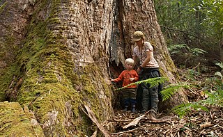
Eucalyptus is a genus of more than 700 species of flowering plants in the family Myrtaceae. Most species of Eucalyptus are trees, often mallees and a few are shrubs. Along with several other genera in the tribe Eucalypteae, including Corymbia and Angophora, they are commonly known as eucalypts. Plants in the genus Eucalyptus have bark that is either smooth, fibrous, hard or stringy, the leaves have oil glands, and the sepals and petals are fused to form a "cap" or operculum over the stamens. The fruit is a woody capsule commonly referred to as a "gumnut".

A woodland is, in the broad sense, land covered with woody plants, or in a narrow sense, synonymous with wood, a low-density forest forming open habitats with plenty of sunlight and limited shade. Some savannas may also be woodlands, such as savanna woodland, where trees and shrubs form a light canopy.

The South East Forests National Park is a national park located in between the Monaro and South Coast regions of New South Wales, Australia. The 115,177-hectare (284,610-acre) national park is situated 378 kilometres (235 mi) southwest of Sydney. It features high quality old growth eucalyptus forest and remnant patches of temperate rainforest.

Temperate rainforests are rainforests with coniferous or broadleaf forests that occur in the temperate zone and receive heavy rain.

The Gondwana Rainforests of Australia, formerly known as the Central Eastern Rainforest Reserves, are the most extensive area of subtropical rainforest in the world. Collectively, the rainforests are a World Heritage Site with fifty separate reserves totalling 366,500 hectares from Newcastle to Brisbane.
East Gippsland is the eastern region of Gippsland, Victoria, Australia covering 31,740 square kilometres (14%) of Victoria. It has a population of 80,114.

Shrubland, scrubland, scrub, brush, or bush is a plant community characterized by vegetation dominated by shrubs, often also including grasses, herbs, and geophytes. Shrubland may either occur naturally or be the result of human activity. It may be the mature vegetation type in a particular region and remain stable over time, or a transitional community that occurs temporarily as the result of a disturbance, such as fire. A stable state may be maintained by regular natural disturbance such as fire or browsing. Shrubland may be unsuitable for human habitation because of the danger of fire. The term was coined in 1903.

Black Forest is an inner southern suburb of Adelaide, South Australia. It is located in the City of Unley, bounded by the Glenelg tram line (north-west), the Seaford railway line (south-east), South Road (west) and East Avenue (east).

Australia has many forests of importance due to significant features, despite being one of the driest continents. As of 2009, Australia has approximately 147 million hectares of native forest, which represents about 19% of Australia's land area. The majority of Australia's trees are hardwoods, typically eucalypts, rather than softwoods like pine. While softwoods dominate some native forests, their total area is judged insufficient to constitute a major forest type in Australia's National Forest Inventory. The Forests Australia website provides up-to-date information on Australia's forests. Detailed information on Australia's forests is available from Australia's State of the Forests Reports that are published every five years.

In the United States, the forest cover by state and territory is estimated from tree-attributes using the basic statistics reported by the Forest Inventory and Analysis (FIA) program of the Forest Service. Tree volumes and weights are not directly measured in the field, but computed from other variables that can be measured.
Hincks Wilderness Protection Area is a protected area in the Australian state of South Australia located in the gazetted locality of Hincks about 87 kilometres north of Port Lincoln and 35 kilometres south east of Lock on the Eyre Peninsula. The wilderness protection area was proclaimed under the Wilderness Protection Act 1992 on 30 September 2004 on land excised from the Hincks Conservation Park.
Talapar Conservation Park is a protected area in the Australian state of South Australia located in the state's Limestone Coast in the gazetted locality of Keppoch about 40 kilometres (25 mi) north-west of the town centre in Naracoorte.
Gower Conservation Park is a protected area located in the Australian state of South Australia in the locality of Tantanoola about 353 kilometres (219 mi) south-east of the state capital of Adelaide and about 25 kilometres (16 mi) north west of the regional city of Mount Gambier.
Glen Roy Conservation Park is a protected area located in the Australian state of South Australia in the locality of Glenroy about 323 kilometres (201 mi) south-east of the state capital of Adelaide and about 25 kilometres (16 mi) north of the town of Penola.
Ramco Point Conservation Park is a protected area located in the Australian state of South Australia in the locality of Sunlands about 150 kilometres (93 mi) north-east of the state capital of Adelaide and about 7 kilometres (4.3 mi) north-west of the municipal seat of Waikerie.
Myponga Conservation Park is a protected area located in the Australian state of South Australia in the locality of Myponga about 59 kilometres (37 mi) south of the state capital of Adelaide and about 5 kilometres (3.1 mi) south-south-west of the town of Myponga.
Deer Reserve National Park is a nature reserve in the Somerset Region of Queensland, in the South East Queensland bioregion. The name "Deer Reserve" refers to a gift of red deer to the Cressbrook Station. Plants protected in Deer Reserve National Park and the adjoining Deer Reserve State Forest include Plectranthus leiperi. It covers an area of 32.3 square kilometers. It is located 480 meters above sea level.
Blackwood River National Park is a national park in Western Australia. It extends along the middle reach of the Blackwood River, the largest river in South West Australia. It is located in the shires of Augusta–Margaret River and Nannup in the South West region. It was designated in 2004, and covers an area of 204.75 km2.