This is a list of bays in the United States.
See also Category:Bays of the United States

The Delmarva Peninsula, or simply Delmarva, is a large peninsula and proposed state on the East Coast of the United States, occupied by the vast majority of the state of Delaware and parts of the Eastern Shore regions of Maryland and Virginia. The peninsula is 170 miles (274 km) long. In width, it ranges from 70 miles (113 km) near its center, to 12 miles (19 km) at the isthmus on its northern edge, to less near its southern tip of Cape Charles. It is bordered by the Chesapeake Bay on the west, Pocomoke Sound on the southwest, and the Delaware River, Delaware Bay, and the Atlantic Ocean on the east.

Raritan River is a major river of New Jersey. Its watershed drains much of the mountainous area of the central part of the state, emptying into the Raritan Bay on the Atlantic Ocean.

A ria is a coastal inlet formed by the partial submergence of an unglaciated river valley. It is a drowned river valley that remains open to the sea.

The Intracoastal Waterway (ICW) is a 3,000-mile (4,800 km) inland waterway along the Atlantic and Gulf of Mexico coasts of the United States, running from Massachusetts southward along the Atlantic Seaboard and around the southern tip of Florida, then following the Gulf Coast to Brownsville, Texas. Some sections of the waterway consist of natural inlets, saltwater rivers, bays, and sounds, while others are artificial canals. It provides a navigable route along its length without many of the hazards of travel on the open sea.

The Atlantic seaboard watershed is a watershed of the Atlantic Ocean in eastern North America along the Atlantic Canada (Maritimes) coast south of the Gulf of Saint Lawrence Watershed, and the East Coast of the United States north of the Kissimmee River watershed of Lake Okeechobee basin in the central Florida Peninsula.

The New York–New Jersey Harbor Estuary, also known as the Hudson-Raritan Estuary, is in the northeastern states of New Jersey and New York on the East Coast of the United States. The system of waterways of the Port of New York and New Jersey forms one of the most intricate natural harbors in the world and one of the busiest ports of the United States. The harbor opens onto the New York Bight in the Atlantic Ocean to the southeast and Long Island Sound to the northeast.
East Bay is a region of the San Francisco Bay Area in Northern California.
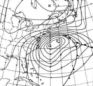
The Ash Wednesday Storm of 1962 occurred on March 5–9, 1962 along the mid-Atlantic coast of the United States. Also known as the Great March Storm of 1962, it was considered by the U.S. Geological Survey to be one of the most destructive storms ever to affect the mid-Atlantic states. Classified as a level 5 or Extreme Nor'easter by the Dolan-Davis scale for classification of Atlantic Nor'easters it was one of the ten worst storms in the United States in the 20th century. It lingered through five high tides over a three-day period, killing 40 people, injuring over 1,000, and causing hundreds of millions in property damage in six states. The storm also deposited significant snowfall over the Southeast, with a regional snowfall index of 12.663.
Ocean Highway was a designation established early in the 20th century for a combination of roadways and water-crossings for motor vehicles which would generally traverse as close as possible to the Atlantic Ocean along the East Coast of the United States from Jacksonville, Florida to North Brunswick, New Jersey. The Ocean Highway concept predated the creation of the Interstate Highway System beginning in the 1950s, and in many states the highways and byways of coastal routes from Florida to North Brunswick still carry the name.

Sinepuxent Bay is an inland waterway which connects Chincoteague Bay to Isle of Wight Bay, and is connected to the Atlantic Ocean via the Ocean City Inlet. It separates Sinepuxent Neck, in Worcester County, Maryland from Assateague Island, and West Ocean City, Maryland from downtown Ocean City. Islands in the Sinepuxent Bay include Horn Island and Skimmer Island. It is crossed by the Harry W. Kelley Memorial Bridge on U.S. Route 50 and the Verrazano Bridge on Maryland Route 611. The bay is the location of the islands that compose the Sinepuxent Bay Wildlife Management Area. Historically the area was referred to by various names including Sinepuxent, Sene Puxon, Synepuxent, Cinnepuxon, et al.

The Great Loop is a system of waterways that encompasses the eastern portion of the United States and part of Canada. It is made up of both natural and man-made waterways, including the Atlantic and Gulf Intracoastal Waterways, the Great Lakes, the Rideau Canal, and the Mississippi and Tennessee-Tombigbee Waterway. The entire loop stretches about 6,000 miles (9,700 km).

USS Blair (DE-147) was an Edsall-class destroyer escort in service with the United States Navy from 1943 to 1946 and from 1951 to 1960. She was scrapped in 1974. Blair was named in honor of Chief Machinist's Mate Eugene Blair, who was awarded the Silver Star posthumously for his brave actions when his ship was attacked and bombed by Japanese planes near Port Darwin, Australia, in mid-February 1942.
The Potawatomi Islands is the most common historic name given to the string of islands that delineate the transition from Green Bay to Lake Michigan, one of the Great Lakes. The archipelago is also termed the "Grand Traverse Islands".
Little Bay, New South Wales is a suburb in south-eastern Sydney, Australia.

The Virginia Barrier Islands are a continuous chain of long, narrow, low-lying, sand and scrub barrier islands separated from one another by narrow inlets and from the mainland by a series of shallow marshy tidal bays along the entire coast of the Virginia end of the Delmarva Peninsula. Several of these islands were once significantly larger, covered with pine forests, and inhabited. After the completion of the New York, Philadelphia and Norfolk Railroad in the late 19th Century, at least five lavish hunting and fishing clubs were established on Virginia's barrier islands and they became a playground for wealthy sportsmen from Northeastern cities who would arrive by train. US President Grover Cleveland visited Hog Island to hunt waterfowl and go fishing in the early 1890s.
