Patchogue Bay

Last updated
Patchogue Bay Great South Bay 11772.JPG
Patchogue Bay

Patchogue Bay is a lagoon [1] on the south-central shores of Long Island in the U.S. state of New York.

Contents

Part of the Great South Bay, Patchogue Bay is a cove between the points of land known as Blue Point and Howells Point, and across which ferries run south to Fire Island.

Ownership

Grant

The Patchogue Bay, bay bottom up to the barrier beach, is owned by Brookhaven town because of a grant from the King of Britain long before the existence of the USA. It has been repeatedly adjudicated that the grant in the Dongan patent (Brookhaven Town, 1686) is valid.[ citation needed ]

Federal government claim

However, since 1968, the Federal Government has been attempting to take title of and claim, by adverse possession, of the bay bottom of both Islip and Brookhaven Towns, extending outward from the barrier beach.[ citation needed ] It (the Federal Government) has repeated published intentionally erroneous maps (as the one below) showing boundaries of the Fire Island Seashore extending out into the bay when the real boundary is the shoreline of the barrier beach. [ citation needed ]

Habitat

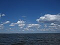
A number of habitats make up the bay bottom; the dominant eelgrass Benthic habitat in the coves of Patchogue Bay which can be classified as muddy sandflat and sandflat habitats. Many species that are found in both habitats. Sandy bottom types worms, slipper shell, and blue mussel, and mud crab. Atlantic oyster dril, a predator of bivalves, is abundant in eelgrass beds in Patchogue and Bellport Bay, and rock crab. The distribution and abundance of benthic species in the bay's eelgrass community is likely controlled by a number of factors that include eelgrass stem density, water temperature and salinity, sediment type, predation, food supply, and human harvest. Much of the bay is open water, while marshes and flats have developed on the protected northern edge of the barrier beach that shelters Patchogue Bay and the mainland from the Atlantic Ocean. Extensive tidal marshes and flats have developed on the bay side of Fire Island as well. Eelgrass beds are concentrated in the shallow waters along the back side of Fire Island, Silversides, killifish, menhaden, and bay anchovy. Forage fish species are found throughout the various aquatic habitats in the bay at different times of the year. Atlantic silverside, the most dominant member through much of the year, in most of the bay. Bay anchovy is the major mid-bay water column occupant in the summer during its spawning time in late June and July. Killifishes include mummichog in the salt marsh habitats, striped killifish over sandy habitat, and sheepshead minnow in both habitats. Sticklebacks, including fourspine and threespine, are spring and summer spawners associated with submerged aquatic vegetation (SAV); although they are very abundant, their use as prey for other fish and birds is limited due to spines, body armor, and close association with vegetative cover. Northern pipefish s) is a zooplankton consumer preyed upon by both striped bass and summer flounder. American sandlance, probably the most abundant winter species, provides important forage for many species of special emphasis in the Bight. Summer flounder enter the bay in winter and spring and grow rapidly in the productive waters. The bay supports significant shellfishery for northern quahog and is a major spawning, nursery, and foraging area for blue crab.

Map showing Patchogue Bay and Fire Island Ferry service. Fire-island-map.jpg
Map showing Patchogue Bay and Fire Island Ferry service.

Other common aquatic species occurring in the backbarrier lagoon systems of Long Island include blue mussel, bay scallop, eastern oyster, horseshoe crab, American eel, spot, Atlantic croaker, northern kingfish, and northern puffer. There are a number of significant trout resources in streams that drain into The Bay. Nine of the twelve verified wild brook trout populations of Long Island occur in the Bay's drainage. Patchogue's Swan River, and many other local tributaries such as Mud Creek, Patchogue Creek, and Terrel Creek all contain naturally reproducing populations of brook trout.

Today, hard clams are the bay's principal resource, but this was not always the case. The once well-known eastern oyster fishery collapsed in the 1940s and 1950s; that collapse was linked to algal blooms of a minute species that inhibited shellfish growth. These blooms were believed to be the result of high inputs of organic wastes, primarily from large-scale duck farms located on tributaries of the bay. A similar problem exists today in lawn fertilizer run off and is directly responsible for brown tide algae bloom and thus indirectly responsible for the collapse of the bay scallop population. During 1999 there was a significant spring drought, which may be verified through the Brookhaven National Laboratory meteorological records. [2] That summer the bay was the cleanest it had been in living memory; one could see clean sand bottom through 5 to 6 feet of water at the edge of the flats. Local baymen and sailors aged 50 and older remarked that they had never seen the bay so clean. There was no "brown tide" algae bloom that year.

Fire Island access and Patchogue bays and bridges

See also

Notes

The original 17th Century Crown Patents, including the Nicolls, Dongan and Fletcher patents, gave certain Long Island townships title to the land within their bounds including the land under water (see O'Brien v Town of Huntington, 66 AD3d 160, 164 [2d Dept 2009]; Melby v Duffy, 304 AD3d 33 [2d Dept 2003]; Nance v Town of Oyster Bay, 23 AD2d 9 [2d Dept 1965]). The townships' ownership and control over these lands and water antedates the State and the Union itself and has been repeatedly upheld (see e.g. Lowndes v Huntington, 153 US 1; Trustees of Brookhaven v Strong, 60 NY 56; Rottenberg v Edwards, 103 AD2d 138 [2d Dept 1984]).

Related Research Articles

East Patchogue, New York Census-designated place in New York, United States

East Patchogue is a census-designated place (CDP) in the Suffolk County town of Brookhaven, New York, United States. The population was 22,469 at the 2010 census. The CDP is a proximate representation of the East Patchogue hamlet used for statistical purposes of the Census Bureau.

Long Island Sound A tidal estuary on the East Coast of the United States

Long Island Sound is a tidal estuary of the Atlantic Ocean, lying predominantly between the U.S. state of Connecticut to the north, and Long Island in New York to the south. From west to east, the sound stretches 110 mi (180 km) from the East River in New York City, along the North Shore of Long Island, to Block Island Sound. A mix of freshwater from tributaries and saltwater from the ocean, Long Island Sound is 21 mi (34 km) at its widest point and varies in depth from 65 to 230 feet.

Brookhaven, New York Town in New York, United States

The Town of Brookhaven is the most populous of the ten towns of Suffolk County, New York, United States. Part of the New York metropolitan area, it is located approximately 50 miles from Manhattan. It is the only town in the county that stretches from the north shore to the south shore of Long Island. It is the largest of New York State's 932 towns by area, and the second most populous after the Town of Hempstead.

Great South Bay

Great South Bay, actually a lagoon, is situated between Long Island and Fire Island, in the State of New York. It is about 45 miles (72 km) long and has an average depth of 4 feet 3 inches and is 20 feet at its deepest. It is protected from the Atlantic Ocean by Fire Island, a barrier island, as well as the eastern end of Jones Beach Island and Captree Island.

Environmental issues in Puget Sound

Puget Sound is a deep inlet of the Pacific Ocean in Washington, extending south from the Strait of Juan de Fuca through Admiralty Inlet. It was explored and named by Captain George Vancouver for his aide, Peter Puget, in 1792.

Yaquina Bay

Yaquina Bay is a coastal estuarine community found in Newport, Oregon, United States. Yaquina Bay is a semi-enclosed body of water, approximately 8 km² (3.2 mi²) in area, with free connection to the Pacific Ocean, but also diluted with freshwater from the Yaquina River land drainage. The Bay is traversed by the Yaquina Bay Bridge. There are three small communities that border the Yaquina River and Bay; Newport, Toledo and Elk City. The Yaquina Bay in Newport is a popular tourist destination along the Pacific Coast Highway. It is also an important estuary for the ecology and economy of the area.

Great Bay (New Hampshire)

Great Bay is a tidal estuary located in Strafford and Rockingham counties in eastern New Hampshire, United States. The bay occupies over 6,000 acres (24 km2), not including its several tidal river tributaries. Its outlet is at Hilton Point in Dover, New Hampshire, where waters from the bay flow into the Piscataqua River, thence proceeding southeast to the Atlantic Ocean near Portsmouth. The northern end of the bay, near its outlet, is referred to as Little Bay.

Outer Barrier

The Outer Barrier, also known as the Long Island and New York City barrier islands, refers to the string of barrier islands that divide the lagoons south of Long Island, New York from the Atlantic Ocean. These islands include Long Beach Barrier Island, Barnum Island, Jones Beach Island, Fire Island and Westhampton Island. The outer barrier extends 75 miles (121 km) along the South Shore of Long Island, from the Rockaway Peninsula in New York City to the east end of Shinnecock Bay in Suffolk County.

Davis Park, New York Hamlet in New York, United States

Davis Park is a hamlet in the Town of Brookhaven, Suffolk County, New York, United States. It is located on Fire Island, a barrier island separated from the southern side of Long Island by the Great South Bay off the South Shore village of Patchogue. It lies within the Fire Island National Seashore.

Great Bay (New Jersey)

Great Bay is located in southern New Jersey's Atlantic Coastal Plain in Ocean and Atlantic Counties, about ten miles (16 km) north of Atlantic City and 87 mi (140 km) south of New York City. The Mullica River flows into the bay, and together they form the Mullica River - Great Bay estuary habitat. The bay is connected to the Atlantic Ocean via the Little Egg Inlet. Great Bay is considered one of the least-disturbed marine wetlands habitats in the northeastern United States.

Topsmelt silverside Species of fish

Atherinops affinis, the topsmelt silverside or simply topsmelt, is a species of Neotropical silverside native to the eastern Pacific Ocean.


The environmental issues on Maury Island are linked to broader Puget Sound environmental issues, which include concerns regarding declining salmon and forage fish populations, degrading critical marine and shoreline habitats, and threatened species such as the Orca.

Swan River (New York)

The Swan River is in Suffolk County on Long Island, New York. It flows into Swan Lake from the north, and then south out of the lake into the mouth of Patchogue Bay, which then becomes the Great South Bay. Originally, the headwaters reached as far north as Medford, New York, near the vicinity of the Long Island Rail Road's Medford station. Swan River is a relatively clean, cold, free flowing, freshwater stream, generally less than 15 feet wide, with a sandy substrate. This segment of the river flows through much undeveloped forested wetland, but has also been encroached upon by residential development, road construction, and a commercial sand mining operation. Below Montauk Highway, the river is tidal, and is bordered by undeveloped marshland and limited development of boat docking facilities. The fish and wildlife habitat encompasses the entire river, including an approximate one and one-half mile tidal segment, and an approximate two and one-half mile freshwater segment, which extends from Swan Lake, above Montauk Highway, to the headwaters of the stream, above Swan Lake, flowing southward into Patchogue Bay.

Sandspit Park Beach & Marina

Sandspit Park Beach & Marina is located on the Patchogue River in the Village of Patchogue in Suffolk County, New York.

Moriches Bay

Moriches Bay is a lagoon system on the south shore of Long Island, New York. The name Moriches comes from Meritces, a Native American who owned land on Moriches Neck.

<i>Zostera marina</i> Species of aquatic plant

Zostera marina is a flowering vascular plant species as one of many kinds of seagrass, with this species known primarily by the English name of eelgrass with seawrack much less used, and refers to the plant after breaking loose from the submerged wetland soil, and drifting free with ocean current and waves to a coast seashore. It is a saline soft-sediment submerged plant native to marine environments on the coastlines of northern latitudes from subtropical to subpolar regions of North America and Eurasia.

Capers Island, South Carolina

Capers Island is a state-owned barrier island on the Atlantic Ocean in Charleston County, South Carolina about 15 miles north of the city of Charleston. It is separated from the mainland by salt marshes and the Intracoastal Waterway. To the southwest it is separated from the barrier island Dewees Island by Capers Inlet. To the northwest, it is separated from the barrier island Bulls Island by Price Inlet.

Climate change in Maryland Effects of climate change in Maryland

Climate change in Maryland encompasses the effects of climate change, attributed to man-made increases in atmospheric carbon dioxide, in the U.S. state of Maryland.

Climate change in Virginia

Climate change in Virginia encompasses the effects of climate change, attributed to man-made increases in atmospheric carbon dioxide, in the U.S. state of Virginia.

References

  1. S. Goodbred, Jr; P. Locicero; V. B onvento; S. Kolbe; S. Holsinger. "History of the Great South Bay estuary: Evidence for a catastrophic origin" (PDF). SUNY.com . Retrieved 2013-10-02.
  2. "Monthly Precipitation Records". Bn1.gov. Retrieved 2014-03-13.

Coordinates: 40°44′32″N73°00′53″W / 40.742315°N 73.014793°W / 40.742315; -73.014793