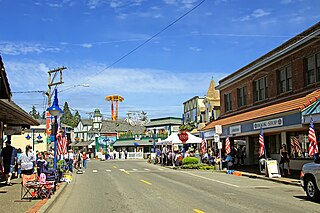
Poulsbo is a city on Liberty Bay in Kitsap County, Washington, United States. It is the smallest of the four cities in Kitsap County. The population was 11,970 at the 2020 census and an estimated 10,927 in 2018.

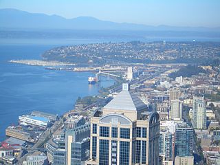
Lake Union is a freshwater lake located entirely within the city limits of Seattle, Washington, United States. It is a major part of the Lake Washington Ship Canal, which carries fresh water from the much larger Lake Washington on the east to Puget Sound on the west. The easternmost point of the lake is the Ship Canal Bridge, which carries Interstate 5 over the eastern arm of the lake and separates Lake Union from Portage Bay. Lake Union is the namesake of the neighborhoods located on three of its shores: Eastlake, Westlake and South Lake Union. Notable destinations on the lake include Lake Union Park, the Museum of History & Industry (MOHAI), and the Center for Wooden Boats on the southern shore and Gas Works Park on the northern shore.

The Duwamish River is the name of the lower 12 miles (19 km) of Washington state's Green River. Its industrialized estuary is known as the Duwamish Waterway. Although heavily polluted, it is an important habitat for the wildlife. Important to the Duwamish people, the Duwamish Longhouse and Cultural Center is on the west bank of the river and several parks have indigenous Lushootseed names.

Haller Lake is a small lake and neighborhood in north central Seattle, Washington, named for Theodore N. Haller, who platted the neighborhood in 1905. His father, Granville O. Haller, was one of Seattle's early settlers, an army officer who amassed a large estate in the region.
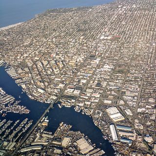
Ballard is a neighborhood in northwestern Seattle, Washington, United States. Formerly an independent city, the City of Seattle's official boundaries define it as bounded to the north by Crown Hill, to the east by Greenwood, Phinney Ridge and Fremont, to the south by the Lake Washington Ship Canal, and to the west by Puget Sound's Shilshole Bay. Other neighborhood or district boundaries existed in the past; these are recognized by various Seattle City Departments, commercial or social organizations, and other Federal, State, and local government agencies.

Salmon Bay is a portion of the Lake Washington Ship Canal, which passes through the city of Seattle, linking Lake Washington to Puget Sound, lying west of the Fremont Cut. It is the westernmost section of the canal and empties into Puget Sound's Shilshole Bay. Because of the Hiram M. Chittenden Locks, the smaller, western half of the bay is salt water, and the eastern half is fresh water.
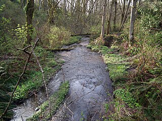
Pipers Creek is a 1.4-mile (2.3 km) urban stream that is located in the Broadview and Blue Ridge neighborhoods of Seattle, Washington, in the United States.
Longfellow Creek is a stream in the Delridge district of West Seattle, in Seattle, Washington. It runs about 3.38 miles (5.4 km) from Roxhill Park north to the Duwamish West Waterway at Elliott Bay. The Duwamish called the creek "Smelt", denoting smelt fish. The creek was a traditional fishery dating back to the 14th century.
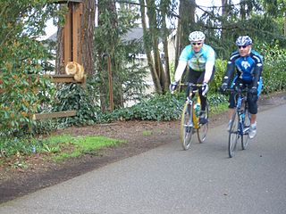
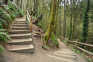
The Burke–Gilman Trail is a rail trail in King County, Washington. The 20-mile (32 km) multi-use recreational trail is part of the King County Regional Trail System and occupies an abandoned Seattle, Lake Shore and Eastern Railway (SLS&E) corridor.

West Point is the westernmost point in Seattle, Washington, United States, jutting into Puget Sound from the Magnolia neighborhood. It also marks the northern extent of Elliott Bay; a line drawn southeastward to Alki Point marks the western extent of the bay. At the point itself is the 1881 West Point Lighthouse, the first staffed light station on Puget Sound. Just to the east is the West Point Treatment Plant, and beyond that, Discovery Park, formerly the U.S. Army's Fort Lawton.

The Ballard Terminal Railroad Company LLC operates two Class III short line terminal railroads in western Washington, United States. Founded in 1997 to operate a three-mile spur through Seattle's Ballard neighborhood, the Ballard Terminal Railroad has expanded to operate two additional lines in the Puget Sound area, including Eastside Freight Railroad from Snohomish to Woodinville, Washington, and Meeker Southern Railroad, a 5 mi (8.0 km) segment from East Puyallup ("Meeker") to McMillin, Washington. Eastside Freight Railroad has ceased operation as of mid 2020.

Golden Gardens Park is a public park in Ballard, a neighborhood of Seattle, Washington. The park includes wetlands, beaches, hiking trails, and picnic and playground areas. The park's bathhouse was designated a historic landmark by the City of Seattle in 2005.
Magnolia is the second largest neighborhood of Seattle, Washington by area, located in northwestern Seattle. It occupies a hilly peninsula northwest of downtown. Magnolia has been a part of the city since 1891. A good portion of the peninsula is taken up by Discovery Park, formerly the U.S. Army's Fort Lawton.
Puget Creek is a small urban creek in the U.S. state of Washington, in the north end of Tacoma, It rises in Puget Park and flows north to Commencement Bay, part of Puget Sound. Its course follows a steep ravine containing Puget Gardens Park. The creek's course is mostly contained within the 66-acre (270,000 m2) natural area of Puget Gulch. Puget Creek is the focus of restoration work by the Puget Creek Restoration Society and community volunteers. One of the restoration goals is the reestablishment of regular runs of coho and chum salmon, as well as sea-run coastal cutthroat trout.

The Old Man House was the largest winter longhouse in what is now the U.S. state of Washington, once standing on the shore of Puget Sound. It was the center of the Suquamish village of dxʷsəq̓ʷəb on Agate Pass, just south of the present-day town of Suquamish. At one time, it was home to the famous Suquamish chiefs Kitsap and Seattle.
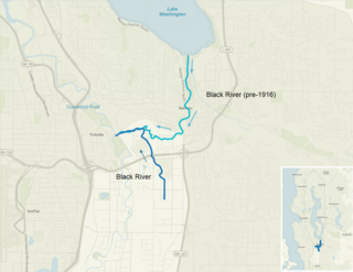
The Black River is a tributary of the Duwamish River in King County in the U.S. state of Washington. It drained Lake Washington until 1916, when the opening of the Lake Washington Ship Canal lowered the lake, causing part of the Black River to dry up. It still exists as a dammed stream about 2 miles (3.2 km) long.

Sunset Hill is an area located in the northwest corner of the Ballard neighborhood of Seattle, Washington. It is home to the Sunset Hill Community Association. Founded in 1922, it was one of the first Seattle neighborhood associations. It is also home to the Sunset Hill Viewpoint Park, located at 7531 34th Ave NW. This park provides a scenic overlook onto the Shilshole and Elliott bays and provides a popular vantage point for photographs of the Olympic Mountains.

Loyal Heights is a neighborhood in Seattle, Washington. It is considered part of greater Ballard.
Ray's Boathouse is a restaurant in the Ballard neighborhood of Seattle, Washington, United States, located on Shilshole Bay along the Puget Sound shoreline. It is noted for its seafood and views of Puget Sound and the Olympic Mountains, and has been listed as one of the city's top restaurants alongside The Herbfarm.

The Shilshole people were a Lushootseed-speaking people whose territory was located around Salmon Bay near Seattle, Washington. Around the 19th century, they had just one village deep inside Salmon Bay. The last Shilshole were removed from their homes in 1914, and moved to the Port Madison Reservation to enable the construction of the Ballard Locks, although some assimilated into the nearby community of Ballard.
