
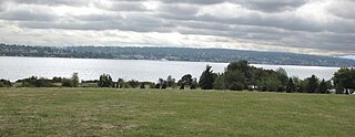
Shilshole Bay is the part of Puget Sound east of a line drawn northeasterly from Seattle's West Point in the southwest to its Golden Gardens Park in the northeast. On its shores lie Discovery Park, the Lawton Wood section of the Magnolia neighborhood, the neighborhood of Ballard, and Golden Gardens Park. It is home to the Shilshole Bay Marina on Ballard's Seaview Avenue N.W. and communicates with the Lake Washington Ship Canal via the Ballard Locks.
Verona Beach State Park is a 1,735-acre (7.02 km2) state park located on the eastern shore of Oneida Lake in the Town of Verona, Oneida County, New York. The park is located on NY 13 northwest of the City of Oneida and south of Sylvan Beach. Oneida Creek enters the Oneida Lake south of the park.

Goose Creek State Park is a North Carolina state park near Washington, Beaufort County, North Carolina in the United States. It covers 1,672 acres (6.77 km2) just off of Pamlico Sound, in North Carolina's Coastal Plain. Goose Creek State Park is home to a wide variety of wildlife that make their homes in the extensive salt water marshes, inlets and creeks on the northern side of the sound. Goose Creek State Park is open for year-round recreation, east of Washington, two miles (3 km) south of U.S. Route 264 on Camp Leach Road.

Seward Park is a municipal park in Seattle, Washington, United States. Located in the city neighborhood of the same name, it covers 300 acres. The park occupies all of Bailey Peninsula, a forested peninsula that juts into Lake Washington. It contains one of the last surviving tracts of old-growth forest within the city of Seattle. The park is named after U.S. Secretary of State William Seward.
Magnuson Park is a park in the Sand Point neighborhood of Seattle, Washington, United States. At 350 acres (140 ha) it is the second-largest park in Seattle, after Discovery Park in Magnolia. Magnuson Park is located at the site of the former Naval Station Puget Sound, on the Sand Point peninsula with Pontiac and Wolf bays that juts into Lake Washington in northeast Seattle.

Carkeek Park is a 216-acre park (87 ha) in the Broadview neighborhood of Seattle, Washington. The park offers various attractions, including Piper Orchard, Pipers Creek with its tributaries, Venema Creek and Mohlendorph Creek, as well as picnic areas, shelters, and hiking trails.

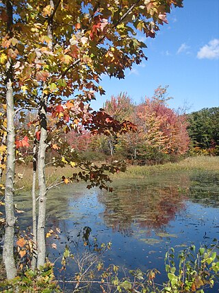
Discovery Park is a 534-acre (2.16 km2) park on the shores of Puget Sound in the Magnolia neighborhood of Seattle, Washington. As the city's largest public park, it contains 11.81 miles (19.01 km) of walking trails. The Discovery Park Loop Trail, designated a National Recreation Trail in 1975, runs 2.8 miles (4.5 km) through the park, connecting to other trails. Forests, beaches, prairies, and bluffs dominate the landscape of the park. Daybreak Star Cultural Center is within the park's boundaries. The West Point Lighthouse is located on West Point, the westernmost point of the park and the entire city of Seattle. On the south side of the North Beach strip is the West Point Treatment Plant which is almost entirely concealed from the marsh, beach, and trail.

Matthews Beach is a neighborhood in Seattle, Washington; it and Meadowbrook are the southern neighborhoods of the annexed township of Lake City (1954). Matthews Beach lies about 2 miles (3.2 km) northeast of the University of Washington, about 8 miles (13 km) northeast of Downtown.

Andrew Haydon Park is a park on the Ottawa River that is managed by the City of Ottawa, Ontario, Canada. It is situated on Carling Avenue at Holly Acres Road.
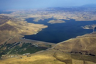
Success Lake is a reservoir near Porterville, California, on the Tule River near the southern end of the Central Valley. It was formed in 1961, when construction of Success Dam was completed.

Miller/Knox Regional Shoreline is a 295-acre (1.19 km2) bayside park near the Brickyard Cove neighborhood of the Point Richmond District in Richmond, California.
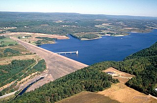
Beltzville State Park is a 2,972.39-acre (1,202.88 ha) Pennsylvania state park in Franklin and Towamensing townships, Carbon County, Pennsylvania in the United States. The park opened in 1972, and was developed around the U.S. Army Corps of Engineers flood control project Beltzville Dam on Pohopoco Creek. The village of Big Creek Valley was vacated in 1966 to make way for Beltzville Lake.

Prince's Island Park is an urban park in the city of Calgary, Alberta, Canada. It is developed on an island on the Bow River, immediately north of downtown Calgary.
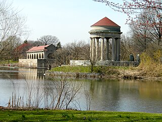
Franklin Delano Roosevelt (FDR) Park is a park located along the Delaware River in the southernmost point of South Philadelphia, Pennsylvania, comprising some 348 acres (1.41 km2), about 125 acres (0.51 km2) of buildings, roadways, pathways for walking, landscaped architecture, and a variety of picnic and recreation areas placed within about 77 acres (310,000 m2) of natural lands including ponds and lagoons.

Camano Island State Park is a publicly owned recreation area on Camano Island in Puget Sound located 14 miles (23 km) southwest of Stanwood in Island County, Washington, United States. The park occupies 173 acres (70 ha) and has 6,700 feet (2,000 m) of shoreline. It is managed by the Washington State Parks and Recreation Commission.

St. Vital Park is a 100 acres (40 ha) park in southern Winnipeg, Manitoba, located on a bend of the Red River. In winter months, a skating pond is situated near the pathways which cover the area. St. Vital Park is also a popular area chosen to have events such as weddings and picnics. It is the third largest park in the city.

Kekaha Kai State Park, formerly known as Kona Coast State Park, is a beach park located along the north Kona coast on the island of Hawaiʻi. The main beach areas are Maniniʻowali Bay, Makalawena beach at Puʻu Aliʻi Bay, and Mahaiʻula Bay. The park's name originates from the Hawaiian language words ke kaha kai which translate to "the shore line" in English.
Mayo River State Park is a North Carolina state park in Rockingham County, North Carolina in the United States. It covers 2,778-acre (11.24 km2) along the Mayo River, and it adjoins a Virginia State Park of the same name. North Carolina's park is near Mayodan, North Carolina. The park is one of the newest in the North Carolina system, having been authorized by the General Assembly in May 2003.
Big Break Regional Shoreline is a 1,648 acre regional park in Oakley, Contra Costa County, northern California. It is a part of the East Bay Regional Park District system and opened in 2005.
Estabrook Park is a Milwaukee County park in the village of Shorewood, Wisconsin and is home to the 1,081 ft (329 m) WITI TV Tower and the historic Benjamin Church House. It was named for Charles E. Estabrook, a distinguished Wisconsin lawyer and politician, and is located on a nearly 125 acre, strip of land between the Milwaukee River and the former Chicago and North Western Railway, now converted into part of the Oak Leaf Trail.

