Bryant, Seattle

Last updated
Bryant, Seattle
Seattle - Bryant School 05.jpg
Bryant School a Historic Landmark located in Bryant.
Seattle - Bryant map.jpg
Bryant Highlighted in Yellow [1]
Coordinates: 47°40′13″N122°17′08″W / 47.67028°N 122.28556°W / 47.67028; -122.28556
CountryUnited States
State Washington
County King
City Seattle
Zip Code
98115
Area Code 206

Bryant is a residential neighborhood in northeast Seattle, Washington. According to the City of Seattle's neighborhood maps (as pictured), [1] it is bounded by 35th Avenue NE and NE 45th Place on the west, beyond which is Ravenna; Sand Point Way NE and 45th Ave NE on the east, beyond which are Laurelhurst and Windermere; and NE 75th Street and NE 65th Street on the north, beyond which are View Ridge and Wedgwood. [1]

Contents

The neighborhood is sometimes known as Ravenna-Bryant, due to its proximity to Ravenna Park. The Burke–Gilman Trail runs along the southern and eastern margins of the neighborhood, paralleling Blakeley Street, Union Bay Place, 45th Street, and Sand Point Way. Bryant Park is located on NE 65th Street at 40th Avenue NE. [2] In late 2012 the Ravenna-Bryant association incorporated a small neighborhood bounded by 35th Avenue NE on the west, 40th Avenue NE on the east, NE 75th Street on the north, and NE 65th Street on the south. The area had previously been a 'donut hole' between the neighborhood belonging to the Ravenna-Bryant association and those of Wedgwood and View Ridge. [3]

The North East branch of the Seattle Public Library, is located at 35th Avenue NE and NE 68th Street. Bryant is also the home to Assumption Catholic Church, University Unitarian Church, Ravenna Methodist, which houses a local preschool cooperative, and three synagogues, Congregation Beth Shalom (Conservative) at 35th Avenue NE and NE 68th Street, Emmanuel Congregation (Modern Orthodox) on NE 65th Street and 35th Avenue NE, and Congregation Shaarei Tefilah–Lubavitch (Orthodox) on NE 65th Street and 43rd Avenue NE.

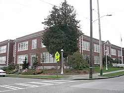
Bryant Elementary School, the Nathan Eckstein Middle School, and the North East Library all have status as Seattle city landmarks, as does Fire Station #38 at 5503 33rd Avenue N.E.

Education

Bryant Elementary School is located at 33rd Avenue NE and NE 60th Street. The school was named after William Cullen Bryant. Bryant School has an event called the Bryant Blast, now in the fall, that offers many games and food, including bouncy toys, cake walks, raffles, and more. On the 4th of July, an annual block party takes place along the two streets west of the elementary school. The neighborhood is also home to the Nathan Eckstein Middle School.

Parks

Bryant Playground Bryant Playground, Seattle, March 2013.jpg
Bryant Playground

Bryant Playground is a 3.1 acre (13,000 m2) playground and park located at N.E. 65th Street and 40th Avenue N.E. This places it at the very northern end of the Hawthorne Hills/Bryant neighborhood or the very southern end of the View Ridge neighborhood. It was acquired by the city in 1976 from Brook Haven Baptist Church for $155,000.[ citation needed ] The park and playground were developed two years later at a cost of $415,000.[ citation needed ]

Calvary Cemetery in Ravenna/Bryant with University of Washington residence towers in background Calvary Cemetery-1.jpg
Calvary Cemetery in Ravenna/Bryant with University of Washington residence towers in background

Commercial Establishments

There are commercial establishments along NE 55th Street between 25th and 35th Avenues NE. The west end is home to the original Kidd Valley burger restaurant. The Duchess Bar on 55th west of 30th Avenue NE is a popular place for patrons to watch University of Washington football games, which are played just south of the neighborhood at Husky Stadium. Across the street is Queen Mary's, a teahouse, and Pair, restaurant specializing in dishes that may be shared. A coffee shop, Ventoux, a Spanish restaurant, Guadi, an Italian café, MioPosto, and several shops, top the hill. The neighborhood is also home to two grocery stores: Puget Consumer Co-op (PCC), a local cooperative chain, at 40th Avenue NE and NE 65th St, and Metropolitan Market, a former Albertsons, [4] on 40th Avenue NE at NE 55th Street, at the southwest corner of the subneighborhood of Hawthorne Hills.

Related Research Articles

<span class="mw-page-title-main">Roosevelt, Seattle</span> Neighborhood in King, Washington, United States

Roosevelt is a neighborhood in north Seattle, Washington. Its main thoroughfare, originally 10th Avenue, was renamed Roosevelt Way upon Theodore Roosevelt's death in 1919. The neighborhood received the name as the result of a Community Club contest held eight years later, in 1927.

<span class="mw-page-title-main">Green Lake, Seattle</span> Seattle Neighborhood in Washington, United States

Green Lake is a neighborhood in north central Seattle, Washington. Its centerpiece is the lake and park after which it is named.

<span class="mw-page-title-main">Wallingford, Seattle</span> Neighborhood of Seattle, Washington

Wallingford is a neighborhood in north central Seattle, lying on a hill above the north shore of Lake Union about four miles from the downtown core. The neighborhood developed quickly during the early 20th century after the establishment of the University of Washington to the east. With trolley tracks laid through the neighborhood as early as 1907, Wallingford is a classic streetcar suburb, typified by its many 1920s era box houses and bungalows. Commercial development is primarily concentrated along North 45th Street where a number of iconic structures stand including the neon "WALLINGFORD" sign, the Wallingford Center, and the original Dick's Drive-In. With its central location, numerous public amenities, including the world-renowned Gas Works Park, and views of both the Olympic and Cascade mountains, Wallingford has long been home to many middle and upper-class families. While Wallingford is mostly residential in nature, the neighborhood's southern edge, along Lake Union, has historically been an industrial and commercial business strip. In recent years, numerous office buildings have been developed as an extension of the burgeoning business center in neighboring Fremont. In 2014 Brooks Sports moved its headquarters from Bothell to a new six-story office building at the southwestern edge of Wallingford.

<span class="mw-page-title-main">Meridian, Seattle</span>

Meridian or Tangletown is the part of Seattle's Wallingford neighborhood that lies north of N 50th Street, near Green Lake. Of note are its "K streets": Kensington, Kenwood, Keystone, and Kirkwood Places N.

<span class="mw-page-title-main">University Village, Seattle</span> Shopping mall in Washington, U.S.

University Village is a shopping mall in Seattle, Washington, United States, located in the south corner of the Ravenna neighborhood to the north of the Downtown area. It is an open-air shopping center which offers restaurants, locally owned boutiques, and national retailers, and is a popular retail destination in the region for home furnishings, popular fashions, gift items, and restaurants.

<span class="mw-page-title-main">Ravenna, Seattle</span> Seattle neighborhood

Ravenna is a neighborhood in northeastern Seattle, Washington named after Ravenna, Italy. Though Ravenna is considered a residential neighborhood, it also is home to several businesses, many of which are located in the University Village, a shopping mall.

<span class="mw-page-title-main">Wedgwood, Seattle</span> Seattle Neighborhood in USA

Wedgwood is a middle class residential neighborhood of northeast Seattle, Washington with a modest commercial strip. Wedgwood is located about two miles (3.2 km) north, and slightly east, of the University of Washington; it is about six miles (9.7 km) northeast of Downtown. The neighborhood is further typical of Seattle neighborhoods in having more than one name and having different, overlapping, but well-documented definitions of the neighborhood.

<span class="mw-page-title-main">Maple Leaf, Seattle</span> Seattle Neighborhood in King, Washington, United States

Maple Leaf is a mostly residential neighborhood located in northeast Seattle.

<span class="mw-page-title-main">Laurelhurst, Seattle</span>

Laurelhurst is a residential neighborhood in Seattle, Washington, US. It is bounded on the northeast by Ivanhoe Place N.E., beyond which is Windermere; on the northwest by Sand Point Way N.E. and N.E. 45th Street, beyond which are Hawthorne Hills, Ravenna, and University Village; on the west by Mary Gates Memorial Drive N.E., beyond which is the East Campus of the University of Washington; on the southwest by Union Bay; and on the east by Lake Washington. Seattle Children's Hospital is located in its northwest corner. Once a seasonal campground of the Duwamish people, the neighborhood has been a part of Seattle since its annexation in 1910.

<span class="mw-page-title-main">Sand Point, Seattle</span>

Sand Point is a neighborhood in Seattle, Washington, United States, named after and consisting mostly of the Sand Point peninsula that juts into Lake Washington, which is itself largely given over to Magnuson Park. Its southern boundary can be said to be N.E. 65th Street, beyond which are Windermere and Hawthorne Hills; its northern boundary, N.E. 95th Street, beyond which is Lake City. The western limit of the neighborhood, beyond which are View Ridge and Wedgwood, is not fixed and can be said to be anywhere up the hill that extends west from Sand Point Way N.E. as far as 35th Avenue N.E. It is also the former home of Seattle Naval Air Station.

<span class="mw-page-title-main">Ravenna Park</span>

Ravenna Park and Cowen Park comprise a single contiguous recreation and green space in the Ravenna neighborhood of Seattle, Washington in the United States. These public parks encompass the ravine with a maximum depth of 115 feet (35 m) through which Ravenna Creek flows.

<span class="mw-page-title-main">View Ridge, Seattle</span> Seattle Neighborhood in King, Washington, United States

View Ridge is a neighborhood in north Seattle, Washington. As with all Seattle neighborhoods, its boundaries are not fixed, but can be thought of as NE 65th Street in the south, 40th and 45th Avenues NE in the west, the Sand Point Country Club in the north, and Sand Point Way NE in the east. Many homes offer views of Lake Washington, Mount Rainier, and the Cascade Range. View Ridge Elementary School is located within the neighborhood, and the neighborhood also offers a large park and playfield across the street from the elementary school. The View Ridge Swim and Tennis Club is located on the eastern edge of View Ridge, and the Sand Point Country Club is located on the northern edge.

Hawthorne Hills is a residential neighborhood in Seattle, Washington. It is officially split between the neighborhoods of Bryant and Windermere, but is generally recognized as a distinct neighborhood. The northern boundary is Northeast 65th Street. The southern and eastern boundary is Sand Point Way. The western boundary is 40th Avenue Northeast. Hawthorne Hills is bounded on the north by View Ridge, on the east by Windermere, on the south by Laurelhurst, and on the west by Bryant. There is a sign for the neighborhood along Sand Point Way.

<span class="mw-page-title-main">Meadowbrook, Seattle</span> Seattle Neighborhood in King, Washington, United States

Meadowbrook is a neighborhood in the Lake City district of Seattle, Washington. Meadowbrook is centered on open fields adjacent to the Community Center, Meadowbrook swimming pool, and Nathan Hale High School. It is bounded on the south by NE 95th Street and the Wedgwood neighborhood, on the north by NE 120th Street and Cedar Park, on the west by Lake City Way NE and Victory Heights, and on the east by 35th Avenue NE and Matthews Beach.

<span class="mw-page-title-main">Cedar Park, Seattle</span>

Cedar Park is a neighborhood in the Lake City district of Seattle, Washington. The name generally refers to the residential neighborhoods east of Lake City adjoining Lake Washington.

<span class="mw-page-title-main">Passyunk Square, Philadelphia</span> Neighborhood of Philadelphia in Philadelphia County, Pennsylvania, United States

Passyunk Square is a neighborhood in South Philadelphia bounded by Broad Street to the west, 6th Street to the east, Tasker Street to the south and Washington Avenue to the north. Passyunk Square is bordered by the Bella Vista, Hawthorne, Central South Philadelphia, Wharton, and Point Breeze neighborhoods. The neighborhood got its Lenape name from the 1800s Passyunk Township, Pennsylvania which named Passyunk Square Park, located between 12th, 13th, Reed and Wharton Streets. The park was eventually renamed Columbus Square Park, and subsequently the neighborhood became known as Columbus Square. Sue Montella, Geoff DiMasi, and a group of neighbors revived the Passyunk Square name when forming the Passyunk Square Civic Association in 2003.

<span class="mw-page-title-main">Cowen Park Bridge</span> Bridge

The Cowen Park Bridge is a reinforced concrete arch bridge in Seattle, Washington. The bridge has a length of 358 feet (109 m) and carries 15th Avenue NE across a ravine in the Cowen Park. The bridges acts as a dividing line in the Ravenna-Cowen Park contiguous area, with the smaller area west of the bridge deemed Cowen Park and the larger area east of the bridge considered Ravenna Park. The bridge, which spans from NE 62nd Street to Cowen Place NE, connects the northern Roosevelt/Ravenna neighborhood with the beginning of the University District. The Cowen Park Bridge is one of two bridges that span the Ravenna Park ravine but is the only one open to vehicular traffic.

References

  1. 1 2 3 "Seattle City Clerk's Geographic Indexing Atlas". City of Seattle. Retrieved 11 June 2023.
  2. "Ravenna-Bryant neighborhood boundary" . Retrieved January 7, 2007.
  3. Sarah Swanberg, "'Donut Hole Adopted by Ravenna-Bryant Community Association", Wedgwood Echo, Volume 27, Issue 1, January 2012, p. 5. http://wedgwoodcc.org/wp-content/uploads/2010/11/Wedgwood-Echo-January-2012.pdf
  4. Gonzalez, Angel (7 September 2015). "Metropolitan Market sticks with slow growth, foodie focus". The Seattle Times. Seattle, WA. Retrieved 22 March 2021.