The Lake Washington Ship Canal is a canal that runs through the city of Seattle and connects the fresh water body of Lake Washington to the salt water inland sea of Puget Sound. The Hiram M. Chittenden Locks accommodate the approximately 20-foot (6.1 m) difference in water level between Lake Washington and the sound. The canal runs east–west and connects Union Bay, the Montlake Cut, Portage Bay, Lake Union, the Fremont Cut, Salmon Bay, and Shilshole Bay, which is part of the sound.

Lake Union is a freshwater lake located entirely within the city limits of Seattle, Washington, United States. It is a major part of the Lake Washington Ship Canal, which carries fresh water from the much larger Lake Washington on the east to Puget Sound on the west. The easternmost point of the lake is the Ship Canal Bridge, which carries Interstate 5 over the eastern arm of the lake and separates Lake Union from Portage Bay. Lake Union is the namesake of the neighborhoods located on three of its shores: Eastlake, Westlake and South Lake Union. Notable destinations on the lake include Lake Union Park, the Museum of History & Industry (MOHAI), and the Center for Wooden Boats on the southern shore and Gas Works Park on the northern shore.

The Fremont Cut is a canal in Seattle, Washington, United States, that connects Lake Union to the east with Salmon Bay to the west. It is part of the Lake Washington Ship Canal linking Lake Washington to Puget Sound, and is 5,800 feet (1,800 m) long and 270 feet (82 m) wide. The center channel is 100 feet (30 m) wide and 30 feet (9.1 m) deep.
Ballard is a neighborhood in northwestern Seattle, Washington, United States. Formerly an independent city, the City of Seattle's official boundaries define it as bounded to the north by Crown Hill, to the east by Greenwood, Phinney Ridge and Fremont, to the south by the Lake Washington Ship Canal, and to the west by Puget Sound's Shilshole Bay. Other neighborhood or district boundaries existed in the past; these are recognized by various Seattle City Departments, commercial or social organizations, and other Federal, State, and local government agencies.

Green Lake is a neighborhood in north central Seattle, Washington. Its centerpiece is the lake and park after which it is named.

The Fremont Troll is a public sculpture in the Fremont neighborhood of Seattle, Washington, United States.

State Route 99 (SR 99), also known as the Pacific Highway, is a state highway in the Seattle metropolitan area, part of the U.S. state of Washington. It runs 49 miles (79 km) from Fife to Everett, passing through the cities of Federal Way, SeaTac, Seattle, Shoreline, and Lynnwood. The route primarily follows arterial streets, including Aurora Avenue, and has several freeway segments, including the tolled SR 99 Tunnel in Downtown Seattle. SR 99 was officially named the William P. Stewart Memorial Highway by the state legislature in 2016, after a campaign to replace an unofficial moniker honoring Confederate president Jefferson Davis.

Wallingford is a neighborhood in north central Seattle, lying on a hill above the north shore of Lake Union about four miles from the downtown core. The neighborhood developed quickly during the early 20th century after the establishment of the University of Washington to the east. With trolley tracks laid through the neighborhood as early as 1907, Wallingford is a classic streetcar suburb, typified by its many 1920s era box houses and bungalows. Commercial development is primarily concentrated along North 45th Street where a number of iconic structures stand including the neon "WALLINGFORD" sign, the Wallingford Center, and the original Dick's Drive-In. With its central location, numerous public amenities, including the Gas Works Park, and views of both the Olympic and Cascade mountains, Wallingford has long been home to many middle and upper-class families. While Wallingford is mostly residential in nature, the neighborhood's southern edge, along Lake Union, has historically been an industrial and commercial business strip. In recent years, numerous office buildings have been developed as an extension of the burgeoning business center in neighboring Fremont. In 2014 Brooks Sports moved its headquarters from Bothell to a new six-story office building at the southwestern edge of Wallingford.

Queen Anne is a neighborhood in northwestern Seattle, Washington. Queen Anne covers an area of 7.3 square kilometers (2.8 sq mi), and has a population of about 28,000. It is bordered by Belltown to the south, Lake Union to the east, the Lake Washington Ship Canal to the north and Interbay to the west.

Interbay is a neighborhood in northwestern Seattle, Washington. It consists of the valley between Queen Anne Hill on the east and Magnolia on the west, plus filled-in areas of Smith Cove and Salmon Bay. The neighborhood is bounded on the north by Salmon Bay, part of the Lake Washington Ship Canal, across which is Ballard; on the south by what remains of Smith Cove, an inlet of Elliott Bay; on the east by 15th Avenue W. and Elliott Avenue W.; and on the west by the BNSF Railway. The Ballard Bridge crosses the ship canal from Interbay to Ballard.

The Fremont Bridge is a double-leaf bascule bridge that spans the Fremont Cut in Seattle, Washington. The bridge, which connects Fremont Avenue North and 4th Avenue North, connects the neighborhoods of Fremont and Queen Anne.

The Aurora Bridge is a cantilever and truss bridge in Seattle, Washington, United States. It carries State Route 99 over the west end of Seattle's Lake Union and connects Queen Anne and Fremont. The bridge is located just east of the Fremont Cut, which itself is spanned by the Fremont Bridge.

Phinney Ridge is a neighborhood in north central Seattle, Washington, United States. It is named after the ridge which runs north and south, separating Ballard from Green Lake, from approximately N. 45th to N. 80th Street. The ridge, in turn, is named after Guy C. Phinney, lumber mill owner and real estate developer, whose estate was bought by the city and turned into Woodland Park in 1899. Phinney's estate had included a private menagerie, and the western half of the park became what is now the Woodland Park Zoo.

Greenwood is a neighborhood in north central Seattle, Washington, United States. The intersection of Greenwood Avenue North and North 85th Street is the commercial center. Greenwood is known for its numerous bars, restaurants, coffee houses, theatres and specialty stores. Greenwood's main thoroughfares are Greenwood Avenue North and N. 85th streets.
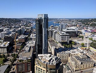
South Lake Union is a neighborhood in central Seattle, Washington, so named because it is at the southern tip of Lake Union.
The Fremont Arts Council (FAC) is a community-run organization that supports arts and artists. The Council resides at the Powerhouse in Fremont, Seattle, Washington with members throughout the city.
Founded in 1998, the History House of Greater Seattle is a historical museum dedicated to the history and heritage of Seattle and its neighborhoods.

Westlake Avenue is a major street in Seattle, Washington, connecting Downtown Seattle to the neighborhoods of South Lake Union, Westlake and northeastern Queen Anne. The street runs north–south along the west side of Lake Union for 2.5 miles (4.0 km) from McGraw Square to the Fremont Bridge.