
Haller Lake is a small lake and neighborhood in north central Seattle, Washington, named for Theodore N. Haller, who platted the neighborhood in 1905. His father, Granville O. Haller, was one of Seattle's early settlers, an army officer who amassed a large estate in the region.

The University District is a neighborhood and a major district in central northeastern Seattle, Washington, comprising several distinct neighborhoods. The main campus of the University of Washington (UW) is located in the district, lending its name to both the district as well as University Way NE.

Roosevelt is a neighborhood in northern Seattle, Washington. Its main thoroughfare, originally 10th Avenue, was renamed Roosevelt Way upon Theodore Roosevelt's death in 1919. The neighborhood received the name as the result of a Community Club contest held eight years later, in 1927.

Green Lake is a neighborhood in north central Seattle, Washington. Its centerpiece is the lake and park after which it is named.

Windermere is a residential neighborhood in northeastern Seattle, Washington, named after Windermere in England's Lake District. It is bounded on the north by Magnuson Park, part of Sand Point; on the northwest by Sand Point Way N.E., beyond which is Hawthorne Hills; on the southwest by Ivanhoe Place N.E., beyond which is Laurelhurst; and on the southeast by Lake Washington. The area has been a part of Seattle since 1910.

State Route 513 (SR 513) is a 3.35-mile-long (5.39 km) state highway in the U.S. state of Washington, located entirely within the city of Seattle in King County. The highway travels north as Montlake Boulevard from an interchange with SR 520 and over the Montlake Bridge to the University of Washington campus in the University District. SR 513 continues past University Village before it turns northeast onto Sand Point Way and ends at the entrance to Magnuson Park in the Sand Point neighborhood.

Meridian or Tangletown is the part of Seattle's Wallingford neighborhood that lies north of N 50th Street, near Green Lake. Of note are its "K streets": Kensington, Kenwood, Keystone, and Kirkwood Places N.
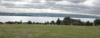
Magnuson Park is a park in the Sand Point neighborhood of Seattle, Washington, United States. At 350 acres (140 ha) it is the second-largest park in Seattle, after Discovery Park in Magnolia. Magnuson Park is located at the site of the former Naval Station Puget Sound, on the Sand Point peninsula with Pontiac and Wolf bays that juts into Lake Washington in northeast Seattle.
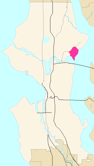
Laurelhurst is a residential neighborhood in northeastern Seattle, Washington, US. It is bounded on the northeast by Ivanhoe Place N.E., beyond which is Windermere; on the northwest by Sand Point Way N.E. and N.E. 45th Street, beyond which are Hawthorne Hills, Ravenna, and University Village; on the west by Mary Gates Memorial Drive N.E., beyond which is the East Campus of the University of Washington; on the southwest by Union Bay; and on the east by Lake Washington. Seattle Children's Hospital is located in its northwest corner. Once a seasonal campground of the Duwamish people, the neighborhood has been a part of Seattle since its annexation in 1910.
Sand Point is a peninsula that juts into Lake Washington from north Seattle, Washington, United States. It is mostly occupied by Magnuson Park and gives its name to the Sand Point neighborhood to the west. Formerly a U.S. naval air station, it is mostly public park area, but with a portion occupied by NOAA.

Bryant is a residential neighborhood in northeastern Seattle, Washington. According to the City of Seattle's neighborhood maps, it is bounded by 35th Avenue NE and NE 45th Place on the west, beyond which is Ravenna; Sand Point Way NE and 45th Ave NE on the east, beyond which are Laurelhurst and Windermere; and NE 75th Street and NE 65th Street on the north, beyond which are View Ridge and Wedgwood.
Houghton is one of the lakeside neighborhoods of the city of Kirkland, Washington. Consisting mostly of upscale, single-family homes, Houghton overlooks Lake Washington and is one of the wealthier districts of the Eastside suburbs of Seattle. The village was named for Willard Houghton, a local lumberman. Houghton incorporated in 1948. In 1950, Census records showed there were 1,065 people living in the town of Houghton. The city of Houghton was annexed by Kirkland in 1968 and became the first community in Washington with a neighborhood council.

Matthews Beach is a neighborhood in Seattle, Washington; it and Meadowbrook are the southern neighborhoods of the annexed township of Lake City (1954). Matthews Beach lies about 2 miles (3.2 km) northeast of the University of Washington, about 8 miles (13 km) northeast of Downtown.

View Ridge is a neighborhood in north Seattle, Washington. As with all Seattle neighborhoods, its boundaries are not fixed, but can be thought of as NE 65th Street in the south, 40th and 45th Avenues NE in the west, the Sand Point Country Club in the north, and Sand Point Way NE in the east. Many homes offer views of Lake Washington, Mount Rainier, and the Cascade Range. View Ridge Elementary School is located within the neighborhood, and the neighborhood also offers a large park and playfield across the street from the elementary school. The View Ridge Swim and Tennis Club is located on the eastern edge of View Ridge, and the Sand Point Country Club is located on the northern edge.
Hawthorne Hills is a residential neighborhood in Seattle, Washington. It is officially split between the neighborhoods of Bryant and Windermere, but is generally recognized as a distinct neighborhood. The northern boundary is Northeast 65th Street. The southern and eastern boundary is Sand Point Way. The western boundary is 40th Avenue Northeast. Hawthorne Hills is bounded on the north by View Ridge, on the east by Windermere, on the south by Laurelhurst, and on the west by Bryant. There is a sign for the neighborhood along Sand Point Way.

Cedar Park is a neighborhood in the Lake City district of Seattle, Washington. The name generally refers to the residential neighborhoods east of Lake City adjoining Lake Washington.
Victory Heights is a neighborhood in the Lake City district of Seattle, Washington. It was named after the Victory Highway, which formed the eastern border of the area. The highway was originally called the Gerhart Erickson Road, the namesake of which was Gerhart Erickson, who sponsored the Good Roads legislation in 1903. The road was then renamed Bothell Road, changed to Victory Highway in 1924, before returning to Bothell Road; it is now called Lake City Way NE. The neighborhood was annexed to the city of Seattle in 1954.
Pinehurst is a neighborhood in the Northgate area of Seattle, Washington, United States. It is bounded by NE 145th Street to the north, NE Northgate Way to the south, I-5 to the west, and Lake City Way to the east. These boundaries were determined by the Pinehurst Community Council. Pinehurst's northern boundary of NE 145th Street makes Pinehurst one of the northernmost neighborhoods in the city of Seattle.

Naval Station Puget Sound is a former United States Naval station located on Sand Point in Seattle, Washington. Today, the land is occupied by Magnuson Park.

Straight Shot is a 2007 public art work at the Sand Point calibration baseline in Magnuson Park, Seattle. It was created by Seattle artist Perri Lynch, and funded by the City of Seattle's 1% for Art program, Trimble and the Washington Surveyors Association. The baseline at Sand Point predates the development of Magnuson Park, and was originally at the western edge of the Navy's Naval Air Station Seattle runway at the location. The artwork was created in part to illustrate the importance of the baseline to surveyors and to preserve the baseline – "in peril of being destroyed" – as a part of the park. The work has been nicknamed "Linehenge" by surveyors.

