Related Research Articles

Shoreline is a city in King County, Washington, United States. It is located between the city limits of Seattle and the Snohomish County border, approximately 9 miles (14 km) north of Downtown Seattle. As of the 2020 census, the population of Shoreline was 58,608, making it the 22nd largest city in the state. Based on per capita income, one of the more reliable measures of affluence, Shoreline ranks 91st of 522 areas in the state of Washington to be ranked.

Haller Lake is a small lake and neighborhood in north central Seattle, Washington, named for Theodore N. Haller, who platted the neighborhood in 1905. His father, Granville O. Haller, was one of Seattle's early settlers, an army officer who amassed a large estate in the region.

The Fremont Cut is a canal in Seattle, Washington, United States, that connects Lake Union to the east with Salmon Bay to the west. It is part of the Lake Washington Ship Canal linking Lake Washington to Puget Sound, and is 5,800 feet (1,800 m) long and 270 feet (82 m) wide. The center channel is 100 feet (30 m) wide and 30 feet (9.1 m) deep.
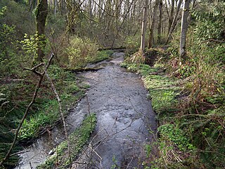
Pipers Creek is a 1.4-mile (2.3 km) urban stream that is located in the Broadview and Blue Ridge neighborhoods of Seattle, Washington, in the United States.

Green Lake is a neighborhood in north central Seattle, Washington. Its centerpiece is the lake and park after which it is named.

The Issaquah Alps is the unofficial name for the highlands near Issaquah, Washington, a suburb of Seattle, including Cougar Mountain, Squak Mountain, Tiger Mountain, Taylor Mountain, Rattlesnake Ridge, Rattlesnake Mountain, and Grand Ridge. The term was invented in 1977 by noted nature author Harvey Manning within the pages of his trail guidebook Footsore 1, elevating their status from foothills to "Alps" to advocate preservation. Manning himself lived on a developed section of Cougar Mountain in his "200 meter hut".

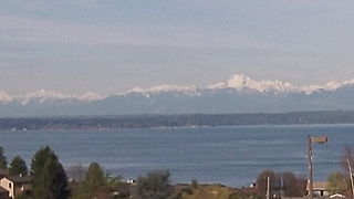
West Seattle is a conglomeration of neighborhoods in Seattle, Washington, United States. It comprises two of the thirteen districts, Delridge and Southwest, and encompasses all of Seattle west of the Duwamish River. It was incorporated as an independent town in 1902 before being annexed by Seattle five years later. Among the area's attractions are its saltwater beach parks along Elliott Bay and Puget Sound, including Alki Beach Park and Lincoln Park. The area is also known for its views of the Olympic Mountains to the west and the Cascade Range to the east. One-third of Seattle's green space and urban forest is located in West Seattle, much of it in the West Duwamish Greenbelt.

West Point is the westernmost point in Seattle, Washington, United States, jutting into Puget Sound from the Magnolia neighborhood. It also marks the northern extent of Elliott Bay; a line drawn southeastward to Alki Point marks the western extent of the bay. At the point itself is the 1881 West Point Lighthouse, the first staffed light station on Puget Sound. Just to the east is the West Point Treatment Plant, and beyond that, Discovery Park, formerly the U.S. Army's Fort Lawton.

Meridian or Tangletown is the part of Seattle's Wallingford neighborhood that lies north of N 50th Street, near Green Lake. Of note are its "K streets": Kensington, Kenwood, Keystone, and Kirkwood Places N.

Greenwood is a neighborhood in north central Seattle, Washington, United States. The intersection of Greenwood Avenue North and North 85th Street is the commercial center. Greenwood is known for its numerous bars, restaurants, coffee houses, theatres and specialty stores. Greenwood's main thoroughfares are Greenwood Avenue North and N. 85th streets.
Broadview is a neighborhood in northwestern Seattle, Washington, United States.

Broadmoor is an 85 acre gated residential community with a 115 acre golf course in Seattle, Washington, United States. It is bounded on the west by the Washington Park Arboretum; on the south by East Madison Street, beyond which is the Washington Park neighborhood; on the east by 37th Avenue East, beyond which is the Madison Park neighborhood; and on the north by Union Bay marshland. It was founded on September 10, 1924.

Delridge is a district in Seattle, Washington, United States that stretches along Delridge Way, an arterial that follows the eastern slope of the valley of Longfellow Creek, from near its source just within the southern city limits north to the West Seattle Bridge over the Duwamish River. It is generally associated with the neighborhing district of West Seattle, or even considered a sub-district of West Seattle.

Crown Hill is a neighborhood in the city of Seattle, in the U.S. state of Washington.

The Suquamish Indian Tribe of the Port Madison Reservation is a federally recognized tribe and Indian reservation in the U.S. state of Washington.

Matthews Beach is a neighborhood in Seattle, Washington; it and Meadowbrook are the southern neighborhoods of the annexed township of Lake City (1954). Matthews Beach lies about 2 miles (3.2 km) northeast of the University of Washington, about 8 miles (13 km) northeast of Downtown.

Atlantic is a neighborhood in the Central District of Seattle, Washington, United States. It is the northernmost neighborhood in the Rainier Valley area, located between Mount Baker Ridge and Beacon Hill, and may also be considered part of South Seattle. It is home to the Judkins Park neighborhood.

Seaview is a neighborhood in West Seattle, Washington. Seaview is bordered by Puget Sound to the west, the Alki and Genesee neighborhoods to the north, Fairmount Park to the east, and Gatewood to the south.

The Facts, also known as Seattle Facts, is an African-American weekly newspaper that serves Seattle, Washington. Headquartered in the Central District, it was founded September 7, 1961 by Fitzgerald Redd Beaver. Printed by Pacific Media Inc. His children, Marla, LaVonne Beaver are currently the publishers and editors. Leaving Mrs.Elizabeth Beaver as the current leader after Beaver's death in 1992 The Facts is a member of the West Coast Black Publishers Association and bills itself as the "Voice of the Black Community."

Loyal Heights is a neighborhood in Seattle, Washington. It is considered part of greater Ballard.
References
- ↑ "Seattle City Clerk's Office Geographic Indexing Atlas". seattle.wa.us. Retrieved 9 August 2015.
- ↑ "Blue Ridge Architectural Review Procedures". blueridgeseattle.com. Retrieved 10 September 2015.
- ↑ "BLUE RIDGE ARCHITECTURAL REVIEW PROCEDURES" . Retrieved 16 August 2020.
47°42′10″N122°22′42″W / 47.702888°N 122.37844°W
| | This King County, Washington state location article is a stub. You can help Wikipedia by expanding it. |