Maple Leaf, Seattle

Last updated

Maple Leaf, Seattle
Seattle Map - Maple Leaf.png
Coordinates: 47°41′44″N122°19′03″W / 47.69556°N 122.31750°W / 47.69556; -122.31750
CountryUnited States
State Washington
County King
City Seattle
Zip Code
98115
Area code 206

Maple Leaf is a mostly residential neighborhood located in northeast Seattle.

Contents

History

The area that is now the Maple Leaf neighborhood appeared on maps in 1894 as a plat by real estate promoters and was called the Maple Leaf Addition to the Green Lake Tract. [1] The name may have come from the Maple Saw Mill that operated to the east on Lake Washington or from some maple trees that once grew in the area. There is also an apocryphal story that Maple Leaf was so far north of downtown Seattle that it got its name for being near Canada. [2]

It wasn't until after World War II that the entirety of Maple Leaf neighborhood was within the Seattle city limits. Prior to 1954 the city line was located at 85th Street, but after a series of annexations took place the city limits moved to its current location of 145th Street. [3]

Neighborhood of the Year

In 1986 Maple Leaf was given the title of national "Neighborhood of the Year" by Neighborhoods USA. Seattle Mayor Charles Royer nominated Maple Leaf for the award. [4]

Boundaries and geography

Although Seattle neighborhood boundaries are unofficial, Maple Leaf lies between Interstate 5 in the west and State Route 522 (also known as Lake City Way) in the east. The neighborhood goes as far north as Northgate Way and as far south as NE 75th Street. [5]

Bordering neighborhoods include Roosevelt neighborhood to the south; Pinehurst and Victory Heights neighborhoods of the Northgate district to the north; Lake City and Wedgwood neighborhoods to the east; North College Park or Licton Springs neighborhood to the west. [6]

The highest point in Maple Leaf, located on 92nd Street and Roosevelt Way, is 466 feet above sea level, making it the third highest point of elevation in Seattle. [7]

Distinctive features of the neighborhood include the water tower and reservoir located at 85th and Roosevelt, plus historic Waldo Hospital at 85th NE and NE 15th, which has since been replaced by an Aegis Living senior housing complex. The water tower is painted with a distinctive coupling of maple leaves viewable from Interstate 5.

Park and reservoir

The Maple Leaf reservoir was completed in 1910 with the purpose of creating a reservoir for residential and commercial water use. [8] In 2009 the Seattle city government began plans to move the reservoir underground. This was part of a citywide plan to replace all open reservoirs with underground structures in order to improve the quality and security of the water supply and provide new public open spaces on reservoir lids throughout Seattle. [9] In 2013 the 16-acre park was completed. [10]

Maple Leaf Playground from near the butterfly garden .jpg
Maple Leaf Playground, near the water tower and the covered Maple Leaf Reservoir that serve as the main recreation area in the neighborhood

Schools and library

Schools

There are two public elementary schools in Maple Leaf which are part of the citywide Seattle Public Schools district.

Along with the two public elementary schools Maple Leaf is home to a handful of private schools.

The Maple Leaf School

Although it would be considered outside of the current Maple Leaf neighborhood's boundaries, the Maple Leaf School opened in 1896 near Lake Washington. [17]

Library

The Northgate Library, which is a branch of the Seattle Public Library system, is located on 10500 block of 5th Avenue, across from Northgate Mall. The library and the adjacent community center and park opened in July 2006. [18]

Related Research Articles

<span class="mw-page-title-main">Fremont, Seattle</span> Seattle Neighborhood in Washington, United States

Fremont is a neighborhood in Seattle, Washington, United States. Originally a separate city, it was annexed to Seattle in 1891. It is named after Fremont, Nebraska, the hometown of two of its founders: Luther H. Griffith and Edward Blewett.

<span class="mw-page-title-main">Roosevelt, Seattle</span> Neighborhood in King, Washington, United States

Roosevelt is a neighborhood in north Seattle, Washington. Its main thoroughfare, originally 10th Avenue, was renamed Roosevelt Way upon Theodore Roosevelt's death in 1919. The neighborhood received the name as the result of a Community Club contest held eight years later, in 1927.

<span class="mw-page-title-main">Thornton Creek</span> Creek in North Seattle that empties into Lake Washington

Thornton Creek is 18 miles (29 km) of urban creeks and tributaries from southeast Shoreline through northeast Seattle to Lake Washington. Its 12-square-mile (31 km2) watershed, the largest in Seattle, exhibits relatively dense biodiversity for an urban setting; it is home to frogs, newts, ducks, herons, and beavers, in addition to more than 75,000 people. From west of Jackson Park Golf Course in Shoreline, from Sunny Walter-Pillings Pond in Licton Springs–North College Park, and north Northgate Thornton Creek flows through Maple Leaf and Lake City, including the Victory Heights, Meadowbrook, and Matthews Beach neighborhoods, and empties into the lake at Matthews Beach Park.

<span class="mw-page-title-main">Green Lake, Seattle</span> Seattle Neighborhood in Washington, United States

Green Lake is a neighborhood in north central Seattle, Washington. Its centerpiece is the lake and park after which it is named.

<span class="mw-page-title-main">Greenwood, Seattle</span> Seattle Neighborhood in King, Washington, United States

Greenwood is a neighborhood in north central Seattle, Washington, United States. The intersection of Greenwood Avenue North and North 85th Street is the commercial center. Greenwood is known for its numerous bars, restaurants, coffee houses, theatres and specialty stores. Greenwood's main thoroughfares are Greenwood Avenue North and North 80th and 85th streets.

<span class="mw-page-title-main">Northgate, Seattle</span> Seattle Neighborhood in King, Washington, United States

Northgate is a neighborhood in north Seattle, Washington, named for and surrounding Northgate Mall, the first covered mall in the United States. Its north-south principal arterials are NE Northgate Way and 130th Street, and its east-west principal arterials are Roosevelt Way NE and Aurora Avenue N. Minor arterials are College Way-Meridian Avenue N, 1st, 5th, and 15th avenues NE. Interstate 5 runs through the district. Besides the eponymous mall, the most characteristic distinctions of the area are North Seattle College (NSC) and the south fork of the Thornton Creek watershed and Seattle Kraken Iceplex center.
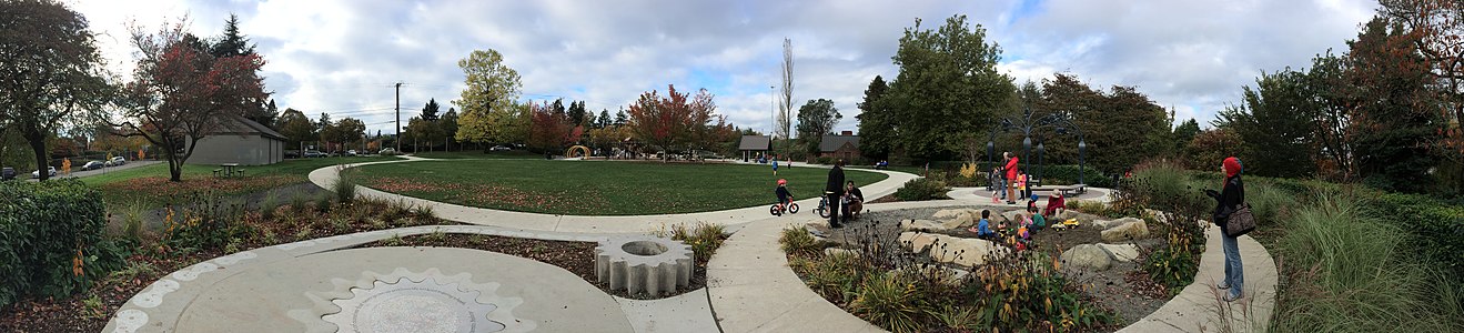
<span class="mw-page-title-main">Wedgwood, Seattle</span> Seattle Neighborhood in USA

Wedgwood is a middle class residential neighborhood of northeast Seattle, Washington with a modest commercial strip. Wedgwood is located about two miles (3.2 km) north, and slightly east, of the University of Washington; it is about six miles (9.7 km) northeast of Downtown. The neighborhood is further typical of Seattle neighborhoods in having more than one name and having different, overlapping, but well-documented definitions of the neighborhood.

<span class="mw-page-title-main">South Lake Union, Seattle</span> Neighborhood of Seattle

South Lake Union is a neighborhood in Seattle, Washington, so named because it is at the southern tip of Lake Union.

<span class="mw-page-title-main">Licton Springs, Seattle</span> Seattle Neighborhood in King, Washington, United States

Licton Springs or North College Park is a neighborhood in the informal Northgate district of North Seattle. It is bounded by Interstate 5 to the east, beyond which is Maple Leaf neighborhood and the Northgate Mall; Aurora Avenue N to the west, beyond which is Greenwood; N 85th Street to the south, beyond which is Green Lake, and N Northgate Way to the north, beyond which is Haller Lake.

<span class="mw-page-title-main">P-Patch</span>

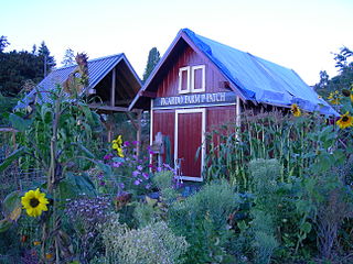
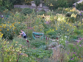
A P-Patch is a parcel of property used for gardening; the term is specific to Seattle, Washington. The "P" originally stood for "Picardo", after the family who owned Picardo Farm in Seattle's Wedgwood neighborhood, part of which became the original P-Patch.

<span class="mw-page-title-main">Northgate Station (shopping mall)</span> Shopping mall

Northgate Station is an enclosed shopping mall in Seattle, Washington, United States. It is located in the Northgate neighborhood on Interstate 5, adjacent to Northgate Way and Northgate station, a light rail station. The mall is anchored by Barnes & Noble, and Nordstrom Rack.

<span class="mw-page-title-main">Northgate Link tunnel</span> Light rail extension and tunnel in Seattle, Washington, U.S.

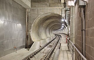
The Northgate Link tunnel is a light rail tunnel in Seattle, Washington, United States. The twin-bore Link light rail tunnel, built as part of the Northgate Link extension, carries a section of the 1 Line and connects the University District to Northgate.

<span class="mw-page-title-main">U District station</span> Light rail station in Seattle, Washington

U District station is a light rail station on the 1 Line of Sound Transit's Link light rail system in Seattle, Washington, United States. It is located in the University District neighborhood, near the University of Washington campus. The underground station has two entrances along Brooklyn Avenue Northeast at 43rd and 45th streets.

<span class="mw-page-title-main">Roosevelt station (Sound Transit)</span> Light rail station in Seattle, Washington

Roosevelt station is a light rail station located in the Roosevelt neighborhood of Seattle, Washington, United States. It is served by the 1 Line of Sound Transit's Link light rail system, which continues north to Northgate station and south to Downtown Seattle and SeaTac. The underground station consists of a single island platform connected to the surface via a mezzanine and two entrances along 12th Avenue Northeast at Northeast 65th and 67th streets.

<span class="mw-page-title-main">Northgate station (Sound Transit)</span> Light rail and bus station in Seattle, Washington, U.S.

Northgate is a light rail and bus station in the Northgate neighborhood of Seattle, Washington, United States. It is the northern terminus of the 1 Line on Sound Transit's Link light rail system. The transit center, located adjacent to the Northgate Mall, has four bus bays served by 22 routes. The station also has parking for 1,525 vehicles.

<span class="mw-page-title-main">Maple Leaf, Toronto</span> Neighbourhood in Toronto, Ontario, Canada

Maple Leaf is a neighbourhood in the city of Toronto, Ontario, Canada. It is located in the southwest of the North York district. Its approximate borders are Lawrence Avenue to the south, Culford Road to the west, Highway 401 to the north, and the CNR rail lines east of Keele Street to the east.

<span class="mw-page-title-main">Peaceful Valley, Spokane</span> Spokane Neighborhood in Washington, United States

Peaceful Valley is a neighborhood in Spokane, Washington. It sits directly below Downtown Spokane on the Spokane River under its falls. The neighborhood snakes along the thin floodplain on the valley floor of the Spokane River Gorge. It is the smallest neighborhood in the city by both area and population, but due to its central location and unique character it is quite notable. The neighborhood has a working class and bohemian culture.

References

  1. Wilma, David. "Seattle Neighborhoods: Maple Leaf -- Thumbnail History". History Link. Retrieved November 11, 2015.
  2. Friedman, Spike. "How Seattle's Neighborhoods Got Their Names". Mental Floss. Retrieved November 11, 2015.
  3. Sheridan, Mimi. "HISTORIC PROPERTY SURVEY REPORT: SEATTLE'S NEIGHBORHOOD COMMERCIAL DISTRICTS" (PDF). City of Seattle. p. 11. Retrieved November 11, 2015.
  4. Case, Fredrick (June 26, 1986). "A PRIZE NEIGHBORHOOD - IT'S MAPLE LEAF'S HOME-SPUN CHARM THAT'S ATTRACTIVE". The Seattle Times. p. E1.
  5. "Neighborhood Map". Maple Leaf Community Council. Archived from the original on August 3, 2012. Retrieved November 11, 2015.
  6. "Seattle City Clerk's Geographic Indexing Atlas". City of Seattle. Retrieved November 11, 2015.
  7. "We're No. 2! Actually Maple Leaf is a proud No. 3". Maple Leaf Life. Retrieved November 11, 2015.
  8. "Periodic Dam Safety Inspection Report" (PDF). Washington State Dept. of Ecology. Retrieved November 11, 2015.
  9. "Maple Leaf Play Area Renovation & Reservoir Park Development Parks and Green Spaces Levy Project Information". Seattle City Government. Seattle Parks and Recreation. Retrieved November 11, 2015.
  10. "Maple Leaf Reservoir Park". Seattle City Government. Seattle Parks and Recreation. Retrieved November 11, 2015.
  11. "Seattle Public Schools, 1862-2000: Olympic View School". Historylink.org. Retrieved December 19, 2013.
  12. "Seattle Public Schools, 1862-2000: Sacajawea Elementary School". Historylink.org. Retrieved December 19, 2013.
  13. "About the Fairview Church". The Fairview Church. Retrieved December 29, 2013.
  14. "Fairview" (PDF). Built for Learning: Seattle Public Schools History. Seattle Public Schools. Archived from the original (PDF) on December 22, 2014.
  15. "Our History". St. Catherine School. Retrieved December 29, 2013.
  16. "History of The Perkins School". The Perkins School. Retrieved December 29, 2013.
  17. "Seattle Public Schools, 1862-2000: Maple Leaf School". History Link. Retrieved November 11, 2015.
  18. "About the Northgate Branch". The Seattle Public Library. Retrieved January 1, 2014.