
Haller Lake is a small lake and neighborhood in north central Seattle, Washington, named for Theodore N. Haller, who platted the neighborhood in 1905. His father, Granville O. Haller, was one of Seattle's early settlers, an army officer who amassed a large estate in the region.

The University District is a neighborhood and a major district in central northeastern Seattle, Washington, comprising several distinct neighborhoods. The main campus of the University of Washington (UW) is located in the district, lending its name to both the district as well as University Way NE.

Fremont is a neighborhood in the North Central District of Seattle, Washington, United States. Originally a separate city, it was annexed to Seattle in 1891. It is named after Fremont, Nebraska, the hometown of two of its founders: Luther H. Griffith and Edward Blewett.

Roosevelt is a neighborhood in northern Seattle, Washington. Its main thoroughfare, originally 10th Avenue, was renamed Roosevelt Way upon Theodore Roosevelt's death in 1919. The neighborhood received the name as the result of a Community Club contest held eight years later, in 1927.

Ravenna Creek is a stream in the Ravenna and Roosevelt neighborhoods of Seattle, Washington, whose present daylighted length of nearly 3,500 feet (1.1 km) is entirely within the Ravenna & Cowen Parks.
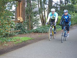
The Burke–Gilman Trail is a rail trail in King County, Washington. The 20-mile (32 km) multi-use recreational trail is part of the King County Regional Trail System and occupies an abandoned Seattle, Lake Shore and Eastern Railway (SLS&E) corridor.

Wallingford is a neighborhood in north central Seattle, lying on a hill above the north shore of Lake Union about four miles from the downtown core. The neighborhood developed quickly during the early 20th century after the establishment of the University of Washington to the east. With trolley tracks laid through the neighborhood as early as 1907, Wallingford is a classic streetcar suburb, typified by its many 1920s era box houses and bungalows. Commercial development is primarily concentrated along North 45th Street where a number of iconic structures stand including the neon "WALLINGFORD" sign, the Wallingford Center, and the original Dick's Drive-In. With its central location, numerous public amenities, including the Gas Works Park, and views of both the Olympic and Cascade mountains, Wallingford has long been home to many middle and upper-class families. While Wallingford is mostly residential in nature, the neighborhood's southern edge, along Lake Union, has historically been an industrial and commercial business strip. In recent years, numerous office buildings have been developed as an extension of the burgeoning business center in neighboring Fremont. In 2014 Brooks Sports moved its headquarters from Bothell to a new six-story office building at the southwestern edge of Wallingford.

Phinney Ridge is a neighborhood in north central Seattle, Washington, United States. It is named after the ridge which runs north and south, separating Ballard from Green Lake, from approximately N. 45th to N. 80th Street. The ridge, in turn, is named after Guy C. Phinney, lumber mill owner and real estate developer, whose estate was bought by the city and turned into Woodland Park in 1899. Phinney's estate had included a private menagerie, and the western half of the park became what is now the Woodland Park Zoo.

Meridian or Tangletown is the part of Seattle's Wallingford neighborhood that lies north of N 50th Street, near Green Lake. Of note are its "K streets": Kensington, Kenwood, Keystone, and Kirkwood Places N.

Greenwood is a neighborhood in north central Seattle, Washington, United States. The intersection of Greenwood Avenue North and North 85th Street is the commercial center. Greenwood is known for its numerous bars, restaurants, coffee houses, theatres and specialty stores. Greenwood's main thoroughfares are Greenwood Avenue North and N. 85th streets.

Maple Leaf is a mostly residential neighborhood located in northeast Seattle.
Laurelhurst is a residential neighborhood in northeastern Seattle, Washington, US. It is bounded on the northeast by Ivanhoe Place N.E., beyond which is Windermere; on the northwest by Sand Point Way N.E. and N.E. 45th Street, beyond which are Hawthorne Hills, Ravenna, and University Village; on the west by Mary Gates Memorial Drive N.E., beyond which is the East Campus of the University of Washington; on the southwest by Union Bay; and on the east by Lake Washington. Seattle Children's Hospital is located in its northwest corner. Once a seasonal campground of the Duwamish people, the neighborhood has been a part of Seattle since its annexation in 1910.
Houghton is one of the lakeside neighborhoods of the city of Kirkland, Washington. Consisting mostly of upscale, single-family homes, Houghton overlooks Lake Washington and is one of the wealthier districts of the Eastside suburbs of Seattle. The village was named for Willard Houghton, a local lumberman. Houghton incorporated in 1948. In 1950, Census records showed there were 1,065 people living in the town of Houghton. The city of Houghton was annexed by Kirkland in 1968 and became the first community in Washington with a neighborhood council.

Mount Baker is a neighborhood in southeastern Seattle, Washington. The neighborhood's name comes from the view of Mount Baker in Whatcom County, that is seen by looking north over Lake Washington. It is bounded by Lake Washington to the east, Interstate 90 and then Leschi to the north, Rainier Valley to the west, and Columbia City to the south. The neighborhood has a community club and a rowing team. It hosts Seattle's annual Seafair, which includes an airshow featuring the U.S. Navy Blue Angels, hydroplane races, a fireworks show, and other festivities. Franklin High School and Garfield High School serve this area. It is part of Seattle's South End.

Northlake is a neighborhood in Seattle, Washington, that consists of the southern part of Wallingford, below N 40th Street. It is so named for being on the northern shore of Lake Union. Landmarks include the Northlake Shipyard, Gas Works Park, the Wallingford Steps art installation, and Ivar's Salmon House. Circa 1900, the eastern part of Northlake was known as Latona, and the John Stanford International School building was formerly the Latona School. Nowadays, the name Latona is likely to refer to anywhere along Latona Ave. NE from Northlake north to NE 65th St. near Green Lake.

Atlantic is a neighborhood in the Central District of Seattle, Washington, United States. It is the northernmost neighborhood in the Rainier Valley area, located between Mount Baker Ridge and Beacon Hill, and may also be considered part of South Seattle. It is home to the Judkins Park neighborhood.

Cedar Park is a neighborhood in the Lake City district of Seattle, Washington. The name generally refers to the residential neighborhoods east of Lake City adjoining Lake Washington.

Olympic Hills is a neighborhood in the Lake City district of Seattle, Washington.
Pinehurst is a neighborhood in the Northgate area of Seattle, Washington, United States. It is bounded by NE 145th Street to the north, NE Northgate Way to the south, I-5 to the west, and Lake City Way to the east. These boundaries were determined by the Pinehurst Community Council. Pinehurst's northern boundary of NE 145th Street makes Pinehurst one of the northernmost neighborhoods in the city of Seattle.

Marra Farm, a 4-acre (1.6 ha) plot of land in Marra-Desimone Park, South Park, Seattle, Washington is one of only two historic agricultural parcels inside Seattle city limits that retains an agricultural use today; the other is Picardo Farm.

