Freeway Park

Last updated

Freeway Park
Aerial view of Freeway Park at night, looking south from Pine and 9th.jpg
Aerial view of Freeway Park at night
Freeway Park
Type Urban park
Location
Coordinates 47°36′35″N122°19′52″W / 47.60972°N 122.33111°W / 47.60972; -122.33111
Area5.2 acres (2.1 ha; 0.0081 sq mi; 0.021 km2) [1]
OpenedJuly 4, 1976;47 years ago (1976-07-04)
Owned by Seattle Parks and Recreation
Operated byFreeway Park Association
Open6:00 a.m. to 10:00 p.m. [2]
Public transit access Sound Transit logo simplified.svg University Street
Architect Lawrence Halprin, Angela Danadjieva
Architectural style Brutalism
NRHP reference No. 100004789
Significant dates
Added to NRHPDecember 19, 2019 [3]
Designated WHROctober 25, 2019 [4]
Designated SEATLMay 18, 2022 [5]

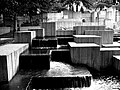
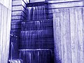
Freeway Park, officially known as Jim Ellis Freeway Park, is an urban park in Seattle, Washington, United States, connecting the city's downtown to the Washington State Convention Center and First Hill. The park sits atop a section of Interstate 5 and a large city-owned parking lot; 8th Avenue also bridges over the park. An unusual mixture of brutalist architecture and greenery, the 5.2-acre (21,000 m2) park, designed by Lawrence Halprin's office under the supervision of Angela Danadjieva, opened to the public on July 4, 1976, at a cost of $23.5 million. [6] An expansion of the park that stretches several blocks up First Hill, including a stairway and wheelchair ramp, was opened in 1982. [7]

Contents

The park is also a cultural landscape and a precedent setting park that, according to The Cultural Landscape Foundation, helped define a new land-use typology for American cities. [8] It was listed on the National Register of Historic Places on December 19, 2019, having been listed on the Washington Heritage Register in a unanimous vote on October 25; [3] [4] it was also declared a Seattle Landmark by the city's landmarks preservation board in a unanimous vote on May 18, 2022. [5]

The park's unique architecture has made it famous among parkour enthusiasts. The World Freerunning and Parkour Federation listed Freeway Park second on its list of the seven best parkour locations in the world. [9]

History

A series of crimes, in particular a murder on January 18, 2002, briefly gave the park a reputation as a haven for crime and led to calls for a radical redesign. [10] Many at first attributed the dangers to the design of the park. A neighborhood group formed under the name Freeway Park Neighborhood Association (FPNA) collaborated with the city's parks and recreation department to produce an "activation plan" for the park, published in 2005 as "A New Vision for Freeway Park". The report has concluded that the park's problems could be remedied by numerous small changes: increased security patrols, better lighting, pruning back of certain plants, and above all increased use, both in terms of organized events and simply encouraging more convention center visitors to use the park. [11] The strategy, only partly implemented as of summer 2005, seems to be succeeding: according to David Brewster of the FPNA, crime in the park is down 90% compared to that of 2002. [12] [13] The park was renovated in 2008 and renamed to honor civic leader Jim Ellis. [14]

Related Research Articles

<span class="mw-page-title-main">Parkour</span> Athletic training disciplines

Parkour is an athletic training discipline or sport in which practitioners attempt to get from point A to point B in the fastest and most efficient way possible, without assisting equipment and often while performing feats of acrobatics. With roots in military obstacle course training and martial arts, parkour includes flipping, running, climbing, swinging, vaulting, jumping, plyometrics, rolling, and quadrupedal movement—whatever is suitable for a given situation. Parkour is an activity that can be practiced alone or with others, and is usually carried out in urban spaces, though it can be done anywhere. It involves seeing one's environment in a new way, and envisioning the potential for navigating it by movement around, across, through, over and under its features.

<span class="mw-page-title-main">Little Red Lighthouse</span> Lighthouse in Manhattan, New York

The Little Red Lighthouse, officially Jeffrey's Hook Light, is a small lighthouse located in Fort Washington Park along the Hudson River in Manhattan, New York City, under the George Washington Bridge. It was made notable by the 1942 children's book The Little Red Lighthouse and The Great Gray Bridge, written by Hildegarde Swift and illustrated by Lynd Ward.

<span class="mw-page-title-main">Washington State Route 520</span> Freeway in Washington state

State Route 520 (SR 520) is a state highway and freeway in the Seattle metropolitan area, part of the U.S. state of Washington. It runs 13 miles (21 km) from Seattle in the west to Redmond in the east. The freeway connects Seattle to the Eastside region of King County via the Evergreen Point Floating Bridge on Lake Washington. SR 520 intersects several state highways, including Interstate 5 (I-5) in Seattle, I-405 in Bellevue, and SR 202 in Redmond.

<span class="mw-page-title-main">Washington State Route 99</span> Highway in the Seattle metropolitan area, Washington, U.S.

State Route 99 (SR 99), also known as the Pacific Highway, is a state highway in the Seattle metropolitan area, part of the U.S. state of Washington. It runs 49 miles (79 km) from Fife to Everett, passing through the cities of Federal Way, SeaTac, Seattle, Shoreline, and Lynnwood. The route primarily follows arterial streets, including Aurora Avenue, and has several freeway segments, including the tolled SR 99 Tunnel in Downtown Seattle. SR 99 was officially named the William P. Stewart Memorial Highway by the state legislature in 2016, after a campaign to replace an unofficial moniker honoring Confederate president Jefferson Davis.

<span class="mw-page-title-main">Volunteer Park (Seattle)</span> Park in Seattle, Washington, U.S.

Volunteer Park is a 48.3-acre (19.5 ha) park in the Capitol Hill neighborhood of Seattle, Washington, United States.

<span class="mw-page-title-main">Queen Anne, Seattle</span> Seattle Neighborhood

Queen Anne is a neighborhood and geographic feature in Seattle, Washington, United States, located northwest of downtown. Queen Anne covers an area of 7.3 square kilometers (2.8 sq mi), and has a population of about 28,000. It is bordered by Belltown to the south, Lake Union to the east, the Lake Washington Ship Canal to the north and Interbay to the west.

<span class="mw-page-title-main">Alaskan Way Viaduct</span> Former elevated highway in Seattle, Washington

The Alaskan Way Viaduct was an elevated freeway in Seattle, Washington, United States, that carried a section of State Route 99. The double-decked freeway ran north–south along the city's waterfront for 2.2 miles (3.5 km), east of Alaskan Way and Elliott Bay, and traveled between the West Seattle Freeway in SoDo and the Battery Street Tunnel in Belltown.

<span class="mw-page-title-main">Washington Park Arboretum</span> Arboretum at the University of Washington

Washington Park is a public park in Seattle, Washington, United States, most of which is taken up by the Washington Park Arboretum, a joint project of the University of Washington, the Seattle Parks and Recreation, and the nonprofit Arboretum Foundation. Washington Park also includes a playfield and the Seattle Japanese Garden in its southwest corner. To the north is Union Bay; to the west are Montlake and Madison Valley; to the south is the Washington Park neighborhood; and to the east is the Broadmoor Golf Club.

<span class="mw-page-title-main">Meridian Hill Park</span> United States historic place

Meridian Hill Park is an urban park in Washington, D.C., located in the Meridian Hill neighborhood that straddles the border between Adams Morgan and Columbia Heights, in Northwest D.C. The park was built between 1912-40 and covers 12-acre (49,000 m2). Meridian Hill Park is bordered by 15th, 16th, W, and Euclid streets NW, and sits on a prominent hill 1.5 miles (2.4 km) directly north of the White House. Since 1969, the name Malcolm X Park is used by some in honor of Malcolm X.

Freerunning is an athletic and acrobatic discipline incorporating an aesthetic element, and can be considered either a sport or a performance art, or both. Freerunning is similar to parkour, from which it is derived, but emphasizes artistry over efficiency and speed. Freerunning involves interacting with physical obstacles in creative ways, such as by climbing, jumping or running; the obstacles may be purpose-built or may be part of a pre-existing natural or man-made environment. The movements are usually adopted from other sports, such as gymnastics, tricking or breakdancing. Freerunners can create their own moves, flows and lines in different landscapes. Practitioners of freerunning usually do parkour as well. Freerunning was founded by Sebastien Foucan, who discussed the subject in 2003 documentary film Jump London.

<span class="mw-page-title-main">Interstate 405 (Washington)</span> Interstate highway bypassing Seattle, Washington, U.S.

Interstate 405 (I-405) is a north–south auxiliary Interstate Highway serving the Seattle region of Washington, United States. It bypasses Seattle east of Lake Washington, traveling through the Eastside area of King and Snohomish counties, providing an alternate route to I-5. The 30-mile (48 km) freeway serves the cities of Renton, Bellevue, Kirkland, and Bothell. I-405 terminates at I-5 in Tukwila and Lynnwood, and also intersects several major highways, including SR 167, I-90, SR 520, and SR 522.

<span class="mw-page-title-main">11th Street Bridges</span> Complex of three bridges across the Anacostia River in Washington, D.C.

The 11th Street Bridges are a complex of three bridges across the Anacostia River in Washington, D.C., United States. The bridges convey Interstate 695 across the Anacostia to its southern terminus at Interstate 295 and DC 295. The bridges also connect the neighborhood of Anacostia with the rest of the city of Washington.

<span class="mw-page-title-main">Crotona Park</span> Public park in the Bronx, New York

Crotona Park is a public park in the South Bronx in New York City, covering 127.5 acres (51.6 ha). The park is bounded by streets of the same name on its northern, eastern, southern, and western borders, and is adjacent to the Crotona Park East and Morrisania neighborhoods of the Bronx. It is divided into four portions by Claremont Parkway and Crotona Avenue, which run through it.

<span class="mw-page-title-main">Interstate 90 in Washington</span> Interstate highway in Washington

Interstate 90 (I-90), designated as the American Veterans Memorial Highway, is a transcontinental Interstate Highway that runs from Seattle, Washington, to Boston, Massachusetts. It crosses Washington state from west to east, traveling 298 miles (480 km) from Seattle across the Cascade Mountains and into Eastern Washington, reaching the Idaho state line east of Spokane. I-90 intersects several of the state's other major highways, including I-5 in Seattle, I-82 and U.S. Route 97 (US 97) near Ellensburg, and US 395 and US 2 in Spokane.

<span class="mw-page-title-main">Interstate 5 in Washington</span> Interstate highway in Washington

Interstate 5 (I-5) is an Interstate Highway on the West Coast of the United States that serves as the region's primary north–south route. It spans 277 miles (446 km) across the state of Washington, from the Oregon state border at Vancouver, through the Puget Sound region, to the Canadian border at Blaine. Within the Seattle metropolitan area, the freeway connects the cities of Tacoma, Seattle, and Everett.

<span class="mw-page-title-main">Waterfront Park (Seattle)</span>

Waterfront Park is a public park on the Central Waterfront, Downtown, Seattle, Washington, USA. Designed by the Bumgardner Partnership and consultants, it was constructed on the site of the former Schwabacher Wharf.

<i>Jump City: Seattle</i> American TV series or program

Jump City: Seattle is an American television series that aired on G4 from February 15 to April 5, 2011. It featured four of the top freerunning and parkour teams in the United States participating in a parkour competition. Each week, the athletes competed in different parkour challenges spread out across the streets of Seattle. The series ran for eight episodes and was not renewed for a second season. Team Tempest, led by Levi Meeuwenberg and Brian Orosco of American Ninja Warrior fame, won the competition.

<span class="mw-page-title-main">Statue of Chief Seattle</span> Statue in Seattle, Washington, U.S.

An outdoor life-size sculpture of Chief Seattle by local artist James Wehn is installed in Tilikum Place in Seattle, Washington, in the United States.

Angela Danadjieva is a landscape architect who founded the multidisciplinary design firm Danadjieva & Koenig Associates with her partner Thomas Koenig. She is well known for her work with Lawrence Halprin & Associates, including the Ira Keller Fountain in Portland, Oregon and Freeway Park in Seattle, Washington.

<span class="mw-page-title-main">Betsy Head Park</span> Public park in Brooklyn, New York

Betsy Head Park is a 10.55-acre (4.27 ha) public park in the Brownsville neighborhood of Brooklyn in New York City. The park occupies two non-contiguous plots diagonally across from each other at the intersection of Dumont Avenue and Thomas S. Boyland Street, covering a collective 10.55 acres (4.27 ha). The modern-day park contains a playground, a swimming complex, and fields for baseball, football, tennis, and basketball. The park's swimming complex, the Betsy Head Play Center, was designed by Ely Jacques Kahn and consists of a bathhouse, a general swimming pool, and an infilled diving pool. The park is operated by the New York City Department of Parks and Recreation, also known as NYC Parks.

References

  1. Annual Report 2019 (Report). Freeway Park Association. April 13, 2020. Retrieved October 25, 2021 via Issuu.
  2. "Freeway Park - Seattle Parks and Recreation". Seattle.gov. City of Seattle . Retrieved October 25, 2021.
  3. 1 2 "Weekly List 20191220 - National Register of Historic Places". National Park Service . United States Department of the Interior. December 20, 2019. Retrieved October 25, 2021.
  4. 1 2 Reiner-Roth, Shane (November 5, 2019). "Seattle's Brutalist Freeway Park is reviewed for National Register and approved for renovation". The Architect's Newspaper . Retrieved October 25, 2021.
  5. 1 2 "Freeway Park in downtown Seattle declared city landmark". KIRO 7 News . May 20, 2022. Retrieved July 8, 2022.
  6. Beckner, Chrisanne (September 2019). "National Register of Historic Places Registration Form: Freeway Park" (PDF). United States Department of the Interior. Archived from the original on October 25, 2021. Retrieved October 25, 2021.
  7. Easton, Valerie (July 27, 2008). "In the concrete jungle, Freeway Park will offer respite once again". The Seattle Times . Archived from the original on June 16, 2018. Retrieved October 27, 2019.
  8. Maryman, Brice; Birkholz, Liz (2005). "Freeway Park/Past, Present and Future?". The Cultural Landscape Foundation. Archived from the original on February 28, 2009. Retrieved May 31, 2009.
  9. Parham, Sam (February 18, 2020). "The 7 Best Parkour Locations in the World". World Freerunning and Parkour Federation . Retrieved February 21, 2021.
  10. Mudede, Charles (August 22, 2002). "Topography of Terror". The Stranger . Retrieved May 31, 2009.
  11. A New Vision for Freeway Park (PDF) (Report). Project for Public Spaces. January 2005. Archived from the original (PDF) on February 18, 2007. Retrieved September 3, 2005.
  12. Brewster, David (August 16, 2005). "Freeway Park". Weekday (Interview). Interviewed by Steve Scher. Seattle, Washington: KUOW. Archived from the original on August 12, 2009. Retrieved May 31, 2009.
  13. Iwasaki, John (July 19, 2005). "Improvements bringing people back to Freeway Park". Seattle Post-Intelligencer . Retrieved May 31, 2009.
  14. Gilmore, Susan (September 3, 2008). "Group pushing to rename Freeway Park". The Seattle Times. p. B4. Retrieved October 27, 2019.

Further reading