
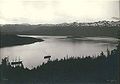
Orca Inlet is an arm of Prince William Sound in southern Alaska. The town of Cordova was founded on its coast in 1906. All marine traffic reaches the town through Orca Inlet.
Orca Inlet is an arm of Prince William Sound in southern Alaska. The town of Cordova was founded on its coast in 1906. All marine traffic reaches the town through Orca Inlet.


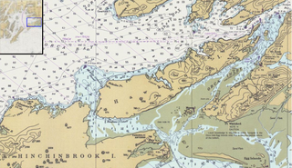
Orca Inlet lies south and east of Hawkins Island at 60°31′25″N145°52′46″W / 60.52361°N 145.87944°W . [1] The Inlet is about 16 miles (26 km) long running southwest and about 3 miles (4.8 km) wide at its widest point. The south end opens into the Gulf of Alaska while the north end joins with Orca Bay. [2]
The city of Cordova, Alaska is situated on the southeast shore of Orca Inlet.
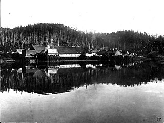
Orca Inlet was listed in the Geographic Dictionary of Alaska in 1906, citing J.F. Moser's report from 1897. The Orca Cannery operated on the south shore of the inlet; there was a post office at that location from 1894. The Odiak Cannery was located 3 miles (4.8 km) southwest of Orca, at the present location of Cordova. [3]
There were once large Pacific razor clam beds in the intertidal zones of Orca Inlet which were harvested and shipped out of Cordova. Harvests reached 3.5 million pounds (1.6 million kilograms) at its peak. Populations began to decline in the late 1950s. When the 1964 Good Friday earthquake struck the clam beds were uplifted around 6 feet (1.8 m) exposing them out of the intertidal zone. This led to moderate mortality and eventually the industry crashed. [4]
Like other arms of Prince William Sound, Orca Inlet is a fjord. There are large areas on its coast with large rounded rocks as well as many cirques and hanging valleys. Glacial erosion created steep walls on the sides of the fjord. In one area the elevation rises to 1,600 feet (490 m) within 1⁄2 mile (0.80 km) of the coastline. The southern and central areas are filled with sediment making the area very shallow. These deposits resulted from the receded glacier that once filled the fjord as well as current inflow through the seaward end of the inlet from the Copper River and other smaller glacial streams. These deposits drift westward along the coast until they reach the entrance of Orca Inlet. Orca Inlet can serve as an entrance to Prince William Sound from the Gulf of Alaska but the shallow water limits the size of vessels that can use the route. In 1914, the southern two-thirds of the inlet was generally 12 feet (3.7 m) deep or less with a few, discontinuous channels, while the north part was 90 to 228 feet (27 to 69 m) deep. [2]
Copper ore has been found in the area around Orca Inlet but there has been little development to mine it. [5]
The tidal current flows southward on the flood and northward on the ebb. Mean velocity at the peak of the flood is 1.5 knots (2.8 km/h; 1.7 mph) and 0.8 knots (1.5 km/h; 0.92 mph) at the peak of the ebb. [6]


Puget Sound is a sound of the Pacific Northwest, an inlet of the Pacific Ocean, and part of the Salish Sea. It is located along the northwestern coast of the U.S. state of Washington. It is a complex estuarine system of interconnected marine waterways and basins, with one major and two minor connections to the open Pacific Ocean via the Strait of Juan de Fuca—Admiralty Inlet being the major connection and Deception Pass and Swinomish Channel being the minor.

The City and Borough of Yakutat is a borough in the U.S. state of Alaska and was the name of a former city within it. The name is Tlingit, Yaakwdáat but it originally derives from an Eyak name diyaʼqudaʼt and was influenced by the Tlingit word yaakw. The borough covers an area about six times the size of the U.S. state of Rhode Island, making it one of the largest counties in the United States. As of the 2010 census, the population was 662, making it the ninth-least populous county nationwide down from 680 in 2000.

Cordova is a city in Chugach Census Area, Alaska, United States. It lies near the mouth of the Copper River, at the head of Orca Inlet on the east side of Prince William Sound. The population was 2,239 at the 2010 census, down from 2,454 in 2000. Cordova was named Puerto Cordova by Spanish explorer Salvador Fidalgo in 1790. No roads connect Cordova to other Alaskan communities, so a plane or ferry is required to travel there. In the Exxon Valdez oil spill of March 1989, an oil tanker ran aground northwest of Cordova, heavily damaging ecology and fishing. It was cleaned up shortly after, but there are lingering effects, such as a lowered population of some birds.

The Kenai Peninsula is a large peninsula jutting from the coast of Southcentral Alaska. The name Kenai is derived from the word "Kenaitze" or "Kenaitze Indian Tribe", the name of the Native Athabascan Alaskan tribe, the Kahtnuht’ana Dena’ina, who historically inhabited the area. They called the Kenai Peninsula Yaghanen.
The Eyak are a Native American indigenous group historically located on the Copper River Delta and near the town of Cordova, Alaska. Today, Eyak people live in Cordova, Yakutat, and across Alaska and the U.S. Many of them do not qualify to be tribal members in the Native Village of Eyak, a federally recognized Alaska Native tribe established through the Alaska Native Claims Settlement Act in 1971, due to the enrollment qualifications that extend tribal membership only to be those who reside in the town of Cordova, Alaska for the majority of the year.

The Copper River or Ahtna River, Ahtna Athabascan ‘Atna’tuu, "river of the Ahtnas", Tlingit Eeḵhéeni, "river of copper", is a 290-mile (470 km) river in south-central Alaska in the United States. It drains a large region of the Wrangell Mountains and Chugach Mountains into the Gulf of Alaska. It is known for its extensive delta ecosystem, as well as for its prolific runs of wild salmon, which are among the most highly prized stocks in the world. The river is the tenth largest in the United States, as ranked by average discharge volume at its mouth.
Glacier Bay Basin in southeastern Alaska, in the United States, encompasses the Glacier Bay and surrounding mountains and glaciers, which was first proclaimed a U.S. National Monument on February 25, 1925, and which was later, on December 2, 1980, enlarged and designated as the Glacier Bay National Park and Preserve under the Alaska National Interest Lands Conservation Act, covering an area of 3,283,000 acres. In 1986, UNESCO declared an area of 57,000 acres within a World Biosphere Reserve. This is the largest UNESCO protected biosphere in the world. In 1992, UNESCO included this area as a part of a World Heritage site, extending over an area of 24,300,000-acre (98,000 km2) which also included the Wrangell-St. Elias National Park, Kluane National Park (Canada) and Tatshenshini-Alsek Park (Canada). Part of the National Park is also designated a Wilderness area covering 2,658,000 acres.
The Chugach National Forest is a 6,908,540-acre (27,958 km2) United States National Forest in south central Alaska. Covering portions of Prince William Sound, the Kenai Peninsula and the Copper River Delta, it was formed in 1907 from part of a larger forest reserve. The Chugach includes extensive shorelines, glaciers, forests and rivers, much of which is untouched by roads or trails. It hosts numerous bird, mammal and marine species, including extensive shorebird habitat and a bald eagle population larger than the contiguous 48 states combined. Human industry in the forest includes extensive tourism and some mining and oil and gas operations.

Yale Glacier is a 20-mile-long (32 km) glacier in the U.S. state of Alaska. It begins at the saddle between Mount Witherspoon and Mount Einstein, and trends southwest to Yale Arm of College Fjord, 47 miles (76 km) west of Valdez. It was named for Yale University by members of the 1899 Harriman Alaska Expedition.
Hawkins Island is an island in the northern part of the Gulf of Alaska in the state of Alaska, United States. It lies just west of the city of Cordova, between that city and the further offshore Hinchinbrook Island. Prince William Sound lies to the north side of the island, while Orca Inlet and the main body of the Gulf of Alaska lie to its south. Hawkins Island has a land area of 176.388 km2 and a population of four persons was reported as of the 2000 census.

Porcher Island is an island in Hecate Strait, British Columbia, Canada, near the mouth of the Skeena River and southwest of the port city of Prince Rupert. The locality of Porcher Island is located near the island's northern tip at Humpback Bay, 54°05′11″N130°23′23″W. Stephens and Prescott Islands are located off its northwestern tip.

Wales Island is an island on the North Coast of British Columbia, Canada, situated east of the Dixon Entrance at the entrance to Portland Inlet.
Holyoke Glacier is a 1.5-mile-long (2.4 km) glacier in the U.S. state of Alaska. It trends southeast on the west bank of College Fjord, 6.8 mi (10.9 km) southwest of College Point and 65 mi (105 km) east of Anchorage. It was named by U.S. Grant and D.F. Higgins, USGS, in 1908. It was named for Mount Holyoke College in South Hadley, Massachusetts.
Orca Bay is a bay in Prince William Sound, Alaska.
Aquaculture in Alaska is dominated by the production of shellfish and aquatic plants. These include Pacific oysters, blue mussels, littleneck clams, scallops, and bull kelp. Finfish farming has been prohibited in Alaska by the 16.40.210 Alaskan statute, however non-profit mariculture continues to provide a steady supply of aquaculture in the state. Many organizations that helped the ban, now encourage the growing of shellfish and other oysters.

Cordova Bay is a bay in the Alexander Archipelago of southeast Alaska. It opens onto Dixon Entrance to the south, between Cape Muzon on Dall Island and Point Marsh. The name Puerto Cordova y Cordova was given by the Spanish explorer Lieutenant Don Jacinto Caamaño in 1792, in honor of Admiral Luis de Córdova y Córdova. The name was published by George Vancouver in 1798.

William Henry Bay is a waterway in the U.S. state of Alaska. It is located near Haines in the Alexander Archipelago. The only commercial copper deposit in Southeast Alaska situated north of Prince of Wales Island was located in the bay. Significant gold and strategic mineral anomalies were found at William Henry Bay during surveys in 2011.
Hunter Bay is a waterway by Prince Edward Island, part of the Alexander Archipelago, in the U.S. state of Alaska. It is situated 2.5 miles (4.0 km) eastward of Turn Point. The entrance of the bay is about 0.75 miles (1.21 km) wide and is obstructed on its northern side by a number of islets, but the channel close around Turn Point is comparatively clear. About 1 mile (1.6 km) above the entrance, the bay contracts to a width of 825 feet (251 m), with a small grassy islet lying in the middle. The best channel is on the northern side of the islet. At approximately 0.5 miles (0.80 km) eastward of the islet is an arm making northward about 2 miles (3.2 km). The depths are shallow and the tidal currents are strong in the narrowest part. There is good anchorage in Hunter Bay. Near the south shore of the bay is an islet surrounded by a flat of considerable extent. Klinkwan is a native village on the north shore of Hunter Bay at its entrance; it has a white church with two spires. Back of the village is a prominent conical mountain, 2,400 feet (730 m) high. Klakas Inlet joins Cordova Bay westward of the entrance to Hunter Bay.
Moira Sound is a branching inlet on the east side of the southern end of Prince of Wales Island in U.S. state of Alaska. It is situated within the Tongass National Forest.
Cholmondeley Sound is a deep bay or inlet on the southeast side of Prince of Wales Island, in the Alexander Archipelago of southeast Alaska, in Tongass National Forest and connecting to Clarence Strait. The sound's entrance lies between Chasina Point and Skin Island. It is about 20 miles (32 km) west of Ketchikan, Alaska. Cholmondeley Sound has several bays and inlets within it, including Kitkun Bay, Dora Bay, Brennan Bay, and Sunny Cove. At its western end Cholmondeley Sound splits into two fjord-like inlets: West Arm Chomondeley Sound, about 7.5 miles (12.1 km) long, and South Arm Cholmondeley Sound, about 8 miles (13 km) long. The full length from the entrance of the sound to the head of West Arm is about 16 miles (26 km).
|journal= (help)