Related Research Articles

Vermilion Parish is a parish located in the U.S. state of Louisiana. As of the 2010 census, the population was 57,999. The parish seat is Abbeville. The parish was created in 1844.
Abbeville is a city in, and the parish seat of, Vermilion Parish, Louisiana, United States, 150 miles (240 km) west of New Orleans and 60 miles (97 km) southwest of Baton Rouge. The population was 12,257 at the 2010 census.

Intracoastal City is an unincorporated community in Vermilion Parish, Louisiana, United States. It is situated on the west bank of the Vermilion River at its junction with the Gulf Intracoastal Waterway and has various port facilities and some permanent residents.
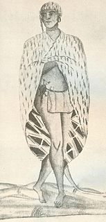
The Atakapa, are an indigenous people of the Southeastern Woodlands, who spoke the Atakapa language and historically lived along the Gulf of Mexico. The competing Choctaw people used this term for this people, and European settlers adopted the term from them. The Atakapan people were made up of several bands. They called themselves the Ishak, which translates as "the people." Within the Ishak there were two moieties which the Ishak identified as "The Sunrise People" and "The Sunset People". Although the people were decimated by infectious disease after European contact and declined as a people, survivors joined other nations. Their descendants still live in the traditional territory of southern Louisiana and Texas. People identifying as Atakapa-Ishak had a gathering in 2006.
USS Vermillion could be referring to a number of different ships in the United States Navy. All of these vessels are named for a bay located in the Gulf of Mexico off the coast of Louisiana, southeast of Vermilion Parish and southwest of Iberia Parish.

The Mississippi Sound is a sound along the Gulf Coast of the United States. It runs east-west along the southern coasts of Mississippi and Alabama, from Waveland, Mississippi, to the Dauphin Island Bridge, a distance of about 90 miles (145 km). The sound is separated from the Gulf on its southern side by the Mississippi–Alabama barrier islands: Cat, Ship, Horn, West Petit Bois, Petit Bois, and Dauphin. Ship, Horn, West Petit Bois and Petit Bois Islands are part of the National Park Service's Gulf Islands National Seashore. Those islands separate the sound from the Gulf of Mexico. The sediment of the islands was created partly by the ancient Mississippi River when the St. Bernard Lobe of the Mississippi Delta was active over two thousand years ago. The expansion of the St. Bernard subdelta slowly isolated the Mississippi Sound from ocean dynamics of the open Gulf of Mexico.
Pecan Island is an unincorporated community with a population of about 300 located in Vermilion Parish, Louisiana, United States. It is located directly under the southern peak of White Lake and two ridges comprise the island, which are actually cheniers or "ridges of high ground" in the coast marsh. There is minimal land in the region, with the island being "an old Gulf beach, composed of crushed shells and sand".

The Vermilion River is a 70.0-mile-long (112.7 km) bayou in southern Louisiana in the United States. It is formed on the common boundary of Lafayette and St. Martin parishes by a confluence of small bayous flowing from St. Landry Parish, and flows generally southward through Lafayette and Vermilion parishes, past the cities of Lafayette and Abbeville. At the port of Intracoastal City, the Gulf Intracoastal Waterway crosses the river before the latter flows into Vermilion Bay, an inlet of the Gulf of Mexico. The river originates at Bayou Fusilier, which is fed by Bayou Teche; winds its way through Lafayette Parish; and drains into the Vermilion Bay below Vermilion Parish.
Marsh Island is an island off the coast of southern Louisiana in the United States.

Barataria Bay, also Barrataria Bay, is a bay of the Gulf of Mexico, about 15 miles (24 km) long and 12 miles (19 km) wide, in southeastern Louisiana, in Jefferson Parish and Plaquemines Parish, United States. It is separated from the gulf by two barrier islands, Grand Isle and Grand Terre.

The Mermentau River is a 72.3-mile-long (116.4 km) river in southern Louisiana in the United States. It enters the Gulf of Mexico between Calcasieu Lake and Vermilion Bay on the Chenier Coastal Plain.
The Delcambre Canal, also known as Bayou Carlin, runs from Lake Peigneur in Louisiana to Vermilion Bay near Weeks Island. It serves to connect the shrimping center of Delcambre to the Gulf of Mexico. It also has a spur connection to Avery Island and crosses the Gulf Intracoastal Waterway. The canal was first dredged in 1906.
Timbalier Bay is a bay in southeastern Louisiana in the United States.
Timbalier Island is an island off southeastern Louisiana in the United States.
The Matagorda Peninsula is a narrow spit of land on the southeastern coast of Texas in the United States.
Lafayette, Louisiana is part of the Gulf Coastal Plain region of the United States and is located at coordinates 30°12′50″N 92°01′46″W. It has an elevation of 36 feet. One of the physical characteristics of the geography include many streams that drain the parish. The primary river that runs through the city is the Vermillion River (Louisiana). This river was formed by the confluence of a few small bayous, stretches about 70 miles long, and drains into the Gulf of Mexico. Most of Lafayette's landscape is urban; however its humid and subtropic climate during the summer allow it to house many species of birds, alligators, and fish. The winter season is mild. While Lafayette is situated in a geographic location that is overall relatively safe, the city is susceptible to flooding; hurricanes are also a common natural disaster.
Southwest Pass is one of the channels at the mouth of the Mississippi River. It empties into the Gulf of Mexico at the southwesternmost tip of the Mississippi River Delta. It lies in Plaquemines Parish in southeastern Louisiana in the United States. It has been the main shipping channel in the Mississippi River Delta since 1853.
Southwest Pass is a narrow strait in Vermilion Parish in southern Louisiana in the United States. It connects the Gulf of Mexico to its south with Vermilion Bay to its north. It is bounded on the east by Marsh Island and on the west by the Louisiana mainland in southeastern Vermilion Parish.
Cote Blanche Bay is a bay in southern Louisiana in the United States. It is divided into East Cote Blanche Bay and West Cote Blanche Bay.
The Vermilion Block 380 A Platform is a fixed offshore platform located in 340 ft (104 m) of water approximately 110 mi (180 km) off the Louisiana coast in the Gulf of Mexico. The platform was originally installed as an oil and gas drilling and production platform in early 1980.
References
- Webster's New Geographical Dictionary. Springfield, Massachusetts: Merriam-Webster, Inc., 1984. ISBN 0-87779-446-4.
Coordinates: 29°43′11″N91°58′34″W / 29.71972°N 91.97611°W
| | This Louisiana state location article is a stub. You can help Wikipedia by expanding it. |