
Lake and Peninsula Borough is a borough in the state of Alaska. As of the 2020 census, the population was 1,476, down from 1,631 in 2010. The borough seat of King Salmon is located in neighboring Bristol Bay Borough, although is not the seat of that borough. The most populous community in the borough is the census-designated place of Port Alsworth. With an average of 0.017 inhabitants per square kilometre, the Lake and Peninsula Borough is the second least densely populated organized county-equivalent in the United States; only the unorganized Yukon-Koyukuk Census Area has a lower density.

The North Slope Borough is the northernmost borough in the US state of Alaska and thus, the northernmost county or equivalent of the United States as a whole. As of the 2020 census, the population was 11,031. The borough seat and largest city, comprising nearly 1/2 of the borough’s population, is Utqiaġvik, the northernmost settlement in the United States.

Carlton is a city in Dickinson County, Kansas, United States. As of the 2020 census, the population of the city was 40.

Hope is a city in southern Dickinson County, Kansas, United States. As of the 2020 census, the population of the city was 317.

Ottawa is a city in, and the county seat of, Franklin County, Kansas, United States. It is located on both banks of the Marais des Cygnes River near the center of Franklin County. As of the 2020 census, the population of the city was 12,625. It is the home of Ottawa University.

Edgerton is a city in Johnson County, Kansas, United States, and part of the Kansas City metropolitan area. As of the 2020 census, the population of the city was 1,748. It is home to a large BNSF intermodal train facility named Logistics Park Kansas City.

Lansing is a city in Leavenworth County, Kansas, United States. It is situated along the west side of the Missouri River and Kansas-Missouri state border. As of the 2020 census, the population of the city was 11,239. It is the second most populous city of Leavenworth County and is a part of the Kansas City metropolitan area. The Lansing Correctional Facility, which includes the state's main maximum-security prison, is located in Lansing.

Lincolnville is a city in Marion County, Kansas, United States. As of the 2020 census, the population of the city was 168. The city was named after Abraham Lincoln, the 16th president of the United States. It is located northeast of Marion, west of the intersection of U.S. Route 77 highway and 290th Street next to the Union Pacific Railroad.

Lyndon is a city in, and the county seat of Osage County, Kansas, United States. As of the 2020 census, the population of the city was 1,037.

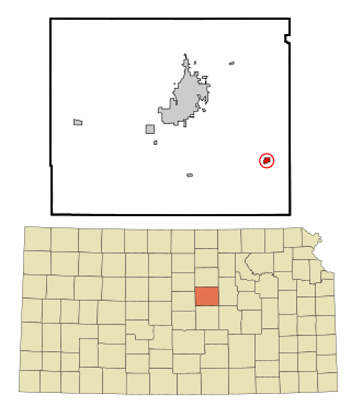
Chase is a city in Rice County, Kansas, United States. As of the 2020 census, the population of the city was 396.
Gypsum is a city in Saline County, Kansas, United States. As of the 2020 census, the population of the city was 400.
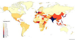
Population density is a measurement of population per unit land area. It is mostly applied to humans, but sometimes to other living organisms too. It is a key geographical term.
In 45 of the 50 states of the United States, the county is used for the level of local government immediately below the state itself. Louisiana uses parishes, and Alaska uses boroughs. In Connecticut, Massachusetts, and Rhode Island, some or all counties within states have no governments of their own; the counties continue to exist as legal entities, however, and are used by states for some administrative functions and by the United States Census bureau for statistical analysis. There are 3,242 counties and county equivalent administrative units in total, including the District of Columbia and 100 county-equivalents in the U.S. territories.
Combined Statistical Area (CSA) is a United States Office of Management and Budget (OMB) term for a combination of adjacent metropolitan (MSA) and micropolitan statistical areas (µSA) across the 50 U.S. states and the territory of Puerto Rico that can demonstrate economic or social linkage. CSAs were first designated in 2003. OMB defines a CSA by various combinations of adjacent metropolitan and micropolitan areas with economic ties measured by commuting patterns. CSAs retain their own designations as metropolitan or micropolitan statistical areas in their respective larger combined statistical areas.

Pilsen is an unincorporated community in Marion County, Kansas, United States. As of the 2020 census, the population of the community and nearby areas was 65. The community is named after the city Plzeň in Czech Republic, formerly Bohemia. It is located north of Marion and west of Lincolnville at the intersection of Remington Road and 275th Street.
 New Jersey is the most densely populated state.
 New York is home to the most populous city in the country, and ranks 8th among the states in density.
 Despite a small population, Vermont has fairly average population density because of its small area.
 Idaho's population has increased rapidly in recent decades, but its population density is lower than other states.
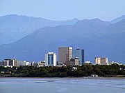 About half of the population of Alaska lives in the Anchorage metropolitan area.
 Puerto Rico is the fourth most densely populated of states and possessions of the U.S.


