List of Guano Island claims

Last updated
Tern island and La Perouse Pinnacle of the French Frigate Shoals Line5394 - Flickr - NOAA Photo Library.jpg
Tern island and La Perouse Pinnacle of the French Frigate Shoals

A number of islands were claimed as insular areas on behalf of the United States under the Guano Islands Act of 1856. These claims were made by private individuals to the U.S. Department of State and were not accepted by the United States unless certain conditions were met. The islands had to be unoccupied and outside the jurisdiction of another government; the claims also had to be bonded before the U.S. government would consider them insular areas of the country. As of 2023, only the eight islands administered as the US Minor Islands and the ones now part of Hawaii and American Samoa remain under the jurisdiction of the United States. Any other unresolved claims, if they exist, are dormant, and have not been contested by the United States in many years with the exception of Navassa.

Contents

Table

IslandRegionAlternate nameCoordinatesCurrent statusResolution of U.S. claim [1]
Alto Velo Island CaribbeanAlta Vela Island; Isla Alto Velo 17°28′42″N71°38′05″W / 17.47833°N 71.63472°W / 17.47833; -71.63472 (Alto Velo Island) Dominican Republic  Claim rejected with U.S. acknowledging Dominican claims. See Alto Velo Claim.
Atafu OceaniaDuke of York Group 8°33′06″S172°30′03″W / 8.55167°S 172.50083°W / -8.55167; -172.50083 (Atafu) Tokelau Claim bonded in 1860, but was never acted upon. Britain claimed in 1899. Final renouncement of any U.S. claim with Treaty of Tokehega
Bajo Nuevo Bank CaribbeanPetrel Islands 15°53′N78°38′W / 15.883°N 78.633°W / 15.883; -78.633 (Bajo Nuevo Bank) DisputedRemains in place as an unincorporated territory.
De facto administered by Colombia, and also claimed by Jamaica and Nicaragua.
Baker Island OceaniaNew Nantucket 0°11′41″N176°28′46″W / 0.19472°N 176.47944°W / 0.19472; -176.47944 (Baker Island) US Minor Islands Unincorporated territory
Birnie Island Oceania 3°35′S171°33′W / 3.583°S 171.550°W / -3.583; -171.550 (Birnie Island) Kiribati Treaty of Tarawa
Butaritari OceaniaMakin Atoll, Makin Island, Touching Island 3°10′04″N172°49′33″E / 3.16778°N 172.82583°E / 3.16778; 172.82583 (Butaritari) Kiribati Treaty of Tarawa
Caroline Island OceaniaMillennium Island 9°56′13″S150°12′42″W / 9.93694°S 150.21167°W / -9.93694; -150.21167 (Caroline Island) Kiribati Treaty of Tarawa
Carondelet Reef Oceania 5°34′S173°51′W / 5.567°S 173.850°W / -5.567; -173.850 (Carondelet Reef) Kiribati Treaty of Tarawa
Clipperton Island Pacific OceanPassion Island 10°18′N109°13′W / 10.300°N 109.217°W / 10.300; -109.217 (Clipperton Island) France U.S. claim never bonded with the U.S. acknowledging France's claim. French and Mexican dispute settled via arbitration in France's favor by King Victor Emmanuel III of Italy in 1931.
Ducie Island Oceania 24°40′09″S124°47′11″W / 24.66917°S 124.78639°W / -24.66917; -124.78639 (Ducie Island) British Territory Never bonded. Administered by Pitcairn Islands.
Enderbury Island OceaniaGuano Island 3°08′S171°05′W / 3.133°S 171.083°W / -3.133; -171.083 (Enderbury Island) Kiribati Treaty of Tarawa
Fakaofo OceaniaBowditch Island 9°21′55″S171°12′54″W / 9.36528°S 171.21500°W / -9.36528; -171.21500 (Fakaofo) Tokelau No formal claim filed; however, any U.S. claim renounced in Treaty of Tokehega
Flint Island Oceania 11°25′48″S151°49′9″W / 11.43000°S 151.81917°W / -11.43000; -151.81917 (Flint Island) Kiribati Treaty of Tarawa
French Frigate Shoals  OceaniaKānemilohaʻi 23°44′56″N166°8′46″W / 23.74889°N 166.14611°W / 23.74889; -166.14611 (French Frigate Shoals) Hawaii Assumed sole competing claim through annexation of Hawaii
(1898); included in State of Hawaii (1959).
Funafuti OceaniaEllice's Group 8°31′S179°13′E / 8.517°S 179.217°E / -8.517; 179.217 (Funafuti) Tuvalu TuvaluUS Treaty of 1983
Howland Island OceaniaWorth Island 0°48′07″N176°38′3″W / 0.80194°N 176.63417°W / 0.80194; -176.63417 (Howland Island) US Minor Islands Unincorporated territory
Isla de Aves CaribbeanIsla de Aves 15°40′18″N63°36′59″W / 15.67167°N 63.61639°W / 15.67167; -63.61639 (Isla Aves) Venezuela United States–Venezuela Maritime Boundary Treaty
Îles du Connétable Atlantic Ocean Constable Islands 4°49′25″N51°56′11″W / 4.82361°N 51.93639°W / 4.82361; -51.93639 (Iles du Connétable) France Rescinded. Administered by French Guiana.
Jarvis Island OceaniaBunker Island 0°22′S160°01′W / 0.367°S 160.017°W / -0.367; -160.017 (Jarvis Island) US Minor Islands Unincorporated territory
Johnston Atoll Oceania 16°44′13″N169°31′26″W / 16.73694°N 169.52389°W / 16.73694; -169.52389 (Johnston Atoll) US Minor Islands Unincorporated territory
Kanton Island OceaniaCanton Island 2°50′S171°40′W / 2.833°S 171.667°W / -2.833; -171.667 (Kanton Island) Kiribati Treaty of Tarawa
Kingman Reef OceaniaDanger Rock 6°24′N162°24′W / 6.400°N 162.400°W / 6.400; -162.400 (Kingman Reef) US Minor Islands Unincorporated territory
Kiritimati OceaniaChristmas Island 1°52′N157°24′W / 1.867°N 157.400°W / 1.867; -157.400 (Kiritimati) Kiribati Treaty of Tarawa
Lacepede Islands OceaniaLacapade [ sic ] Islands 16°51′55″S122°08′12″E / 16.86528°S 122.13667°E / -16.86528; 122.13667 (Lacepede Islands) Australia Claim made on 26 June 1876; repudiated by US government in 1877.
Makin (atoll) OceaniaLittle Makin 3°23′00″N173°00′00″E / 3.38333°N 173.00000°E / 3.38333; 173.00000 (Makin (islands)) Kiribati Treaty of Tarawa
Malden Island OceaniaIndependence Island 4°01′S154°56′W / 4.017°S 154.933°W / -4.017; -154.933 (Malden Island) Kiribati Treaty of Tarawa
Manihiki OceaniaIsland of Pearls 10°24′S161°00′W / 10.400°S 161.000°W / -10.400; -161.000 (Manihiki) Cook Islands Cook Islands–United States Maritime Boundary Treaty
Manra OceaniaSydney Island 4°27′S171°16′W / 4.450°S 171.267°W / -4.450; -171.267 (Manra Island) Kiribati Treaty of Tarawa
McKean Island OceaniaWigram Island 3°35′S174°02′W / 3.583°S 174.033°W / -3.583; -174.033 (McKean Island) Kiribati Treaty of Tarawa
Midway Atoll OceaniaMiddlebrook Islands 28°12′N177°21′W / 28.200°N 177.350°W / 28.200; -177.350 (Midway Atoll) US Minor Islands Unincorporated territory
Minami-Tori-shima OceaniaMarcus Island 24°18′N153°58′E / 24.300°N 153.967°E / 24.300; 153.967 (Minami Torishima) Japan Returned to Japan in 1968 after it had been given to US by Treaty of San Francisco
Navassa Island CaribbeanNavaza 18°24′10″N75°0′45″W / 18.40278°N 75.01250°W / 18.40278; -75.01250 (Navassa Island) DisputedAdministered by the United States as an unincorporated territory and one of the US Minor Islands. Also claimed by Haiti.
Nikumaroro OceaniaGardner Island 4°40′S174°31′W / 4.667°S 174.517°W / -4.667; -174.517 (Nikumaroro) Kiribati Treaty of Tarawa
Niulakita OceaniaSophia Island, Rocky Island, Nurakita 10°45′S179°30′E / 10.750°S 179.500°E / -10.750; 179.500 (Niulakita) Tuvalu TuvaluUS Treaty of 1983
Nukufetau OceaniaDe Peyster's Group 8°00′S178°30′E / 8.000°S 178.500°E / -8.000; 178.500 (Nukufetau) Tuvalu TuvaluUS Treaty of 1983
Nukulaelae OceaniaMitchell's Group 9°22′52″S179°51′08″E / 9.38111°S 179.85222°E / -9.38111; 179.85222 (Nukulaelae) Tuvalu TuvaluUS Treaty of 1983
Nukunonu OceaniaDuke of Clarence Island 9°10′06″S171°48′35″W / 9.16833°S 171.80972°W / -9.16833; -171.80972 (Nukunonu) Tokelau Claim bonded in 1860, but was never acted upon. Britain claimed in 1899. Final renouncement of any U.S. claim with Treaty of Tokehega
Orona OceaniaHull Island 4°30′S172°10′W / 4.500°S 172.167°W / -4.500; -172.167 (Orona) Kiribati Treaty of Tarawa
Palmyra Atoll Oceania 5°53′N162°5′W / 5.883°N 162.083°W / 5.883; -162.083 (Palmyra Atoll) US Minor Islands Incorporated territory. [2] U.S. assumed sole competing claim through annexation of Hawaii (1898), but not included in State of Hawaii (1959).
Penrhyn Island OceaniaTongareva 9°00′20″S157°58′10″W / 9.00556°S 157.96944°W / -9.00556; -157.96944 (Penrhyn Island) Cook Islands Cook Islands–United States Maritime Boundary Treaty
Providence Island Indian Ocean 9°13′7″S51°1′47″E / 9.21861°S 51.02972°E / -9.21861; 51.02972 (Providence Island) Seychelles Claim never bonded. Administered by Seychelles.
Pukapuka OceaniaSan Bernardo Island 10°53′S165°40′W / 10.883°S 165.667°W / -10.883; -165.667 (Pukapuka) Cook Islands Cook Islands–United States Maritime Boundary Treaty
Quita Sueño Bank CaribbeanQuitasueño 14°19′N81°10′W / 14.317°N 81.167°W / 14.317; -81.167 (Quita Sueño Bank) Colombia Vásquez–Saccio Treaty of 1972
Rakahanga OceaniaGrand Duke Alexander Island  10°02′S161°05′W / 10.033°S 161.083°W / -10.033; -161.083 (Rakahanga) Cook Islands Cook Islands–United States Maritime Boundary Treaty
Rawaki Island OceaniaPhoenix Island 3°42′40″S170°42′43″W / 3.71111°S 170.71194°W / -3.71111; -170.71194 (Rawaki Island) Kiribati Treaty of Tarawa
Roncador Bank Caribbean 13°34′N80°05′W / 13.567°N 80.083°W / 13.567; -80.083 (Roncador Bank) Colombia Vásquez–Saccio Treaty of 1972
Scorpion Reef Gulf of Mexico Arrecife Alacranes (Isla Pérez, Isla Chica, Isla Pájaros) 22°24′N89°42′W / 22.400°N 89.700°W / 22.400; -89.700 (Scorpion Reef) Mexico The islets of Pájaros, Pérez, and Chica were bonded in 1884. In response to a protest by Mexico, the U.S. claims were abandoned in 1894. [3]
Serrana Bank Caribbean 14°20′N80°20′W / 14.333°N 80.333°W / 14.333; -80.333 (Serrana Bank) Colombia Vásquez–Saccio Treaty of 1972
Serranilla Bank Caribbean 15°50′N79°50′W / 15.833°N 79.833°W / 15.833; -79.833 (Serranilla Bank) DisputedRemains in place as an unincorporated territory. Colombia and Jamaica agreed to a condominium of Serranilla's exclusive economic zone; Nicaragua also lays claim.
Starbuck Island OceaniaVolunteer Island 5°37′S155°56′W / 5.617°S 155.933°W / -5.617; -155.933 (Starbuck Island) Kiribati Treaty of Tarawa
Swains Island [4] OceaniaOlohega, Olosega, Quirós, Isla de la Gente Hermosa, Jennings Island 11°03′20″S171°04′40″W / 11.05556°S 171.07778°W / -11.05556; -171.07778 (Swains Island) American Samoa Occupied by an American since 1856. Bonded under the Guano Islands Act in 1860. Acknowledged as U.S. territory by Britain in 1910. In 1925 was incorporated into the territory of American Samoa. U.S. claim recognized in Treaty of Tokehega.
Swan Islands CaribbeanIslas Santanilla 17°24′38″N83°55′19″W / 17.41056°N 83.92194°W / 17.41056; -83.92194 (Swan Islands) Honduras HondurasUS Treaty of 1972
Tabuaeran OceaniaFanning Island 3°51′36″N159°21′52″W / 3.86000°N 159.36444°W / 3.86000; -159.36444 (Tabuaeran) Kiribati Treaty of Tarawa
Teraina OceaniaWashington Island 4°41′00″N160°22′40″W / 4.68333°N 160.37778°W / 4.68333; -160.37778 (Teraina) Kiribati Treaty of Tarawa
Vostok Island OceaniaStaver Island 10°06′S152°23′W / 10.100°S 152.383°W / -10.100; -152.383 (Vostok Island) Kiribati Treaty of Tarawa
Winslow Reef Oceania 1°36′S174°57′W / 1.600°S 174.950°W / -1.600; -174.950 (Winslow Reef) Kiribati Treaty of Tarawa

Images

Map all coordinates using: OpenStreetMap

See also

Related Research Articles

<span class="mw-page-title-main">Baker Island</span> Uninhabited Pacific atoll administered by the United States

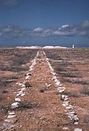
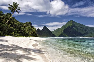
Baker Island, formerly known as New Nantucket, is an uninhabited atoll just north of the Equator in the central Pacific Ocean about 3,090 km (1,920 mi) southwest of Honolulu. The island lies almost halfway between Hawaii and Australia. Its nearest neighbor is Howland Island, 42 mi (68 km) to the north-northwest; both have been claimed as territories of the United States since 1857, though the United Kingdom considered them part of the British Empire between 1897 and 1936.

<span class="mw-page-title-main">Howland Island</span> US-controlled coral island in the central Pacific Ocean

Howland Island is an uninhabited coral island located just north of the equator in the central Pacific Ocean, about 1,700 nautical miles (3,100 km) southwest of Honolulu. The island lies almost halfway between Hawaii and Australia and is an unorganized, unincorporated territory of the United States. Together with Baker Island it forms part of the Phoenix Islands. For statistical purposes, Howland is grouped as one of the United States Minor Outlying Islands. The island has an elongated cucumber-shape on a north–south axis, 1.40 by 0.55 miles, and covers 1 square mile.

<span class="mw-page-title-main">Kingman Reef</span> Reef and unincorporated U.S. territory in the Pacific Ocean

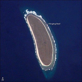
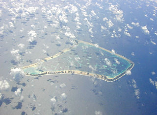
Kingman Reef is a largely submerged, uninhabited, triangle-shaped reef, geologically an atoll, 9.0 nmi (20 km) east-west and 4.5 nmi (8 km) north-south, in the North Pacific Ocean, roughly halfway between the Hawaiian Islands and American Samoa. It has an area of 3 hectares and is one of the unincorporated territories of the United States in Oceania. The reef is administered by the United States Fish and Wildlife Service as the Kingman Reef National Wildlife Refuge.

<span class="mw-page-title-main">Navassa Island</span> Caribbean island administered by the United States, claimed by Haiti

Navassa Island is a small uninhabited island in the Caribbean Sea. Located northeast of Jamaica, south of Cuba, and 40 nautical miles west of Jérémie on the Tiburon Peninsula of Haiti, it is subject to an ongoing territorial dispute between Haiti and the United States, which administers the island through the U.S. Fish and Wildlife Service.

<span class="mw-page-title-main">United States Minor Outlying Islands</span> Statistical designation of small islands of the United States

The United States Minor Outlying Islands is a statistical designation defined by the International Organization for Standardization's ISO 3166-1 code. The entry code is ISO 3166-2:UM. The minor outlying islands and groups of islands consist of eight United States insular areas in the Pacific Ocean and one in the Caribbean Sea.

In the United States, a territory is any extent of region under the sovereign jurisdiction of the federal government of the United States, including all waters. The United States asserts sovereign rights for exploring, exploiting, conserving, and managing its territory. This extent of territory is all the area belonging to, and under the dominion of, the United States federal government for administrative and other purposes. The United States total territory includes a subset of political divisions.

<span class="mw-page-title-main">Insular area</span> U.S. territory that is neither a U.S. state nor the District of Columbia

In the law of the United States, an insular area is a U.S.-associated jurisdiction that is not part of the 50 states or the District of Columbia. This includes fourteen U.S. territories administered under U.S. sovereignty, as well as three sovereign states each with a Compact of Free Association with the United States. The term also may be used to refer to the previous status of the Philippine Islands and the Trust Territory of the Pacific Islands when it existed.

<span class="mw-page-title-main">Territories of the United States</span>

Territories of the United States are sub-national administrative divisions overseen by the federal government of the United States. The various American territories differ from the U.S. states and Indian reservations as they are not sovereign entities. In contrast, each state has a sovereignty separate from that of the federal government and each federally recognized Native American tribe possesses limited tribal sovereignty as a "dependent sovereign nation." Territories are classified by incorporation and whether they have an "organized" government through an organic act passed by the Congress. American territories are under American sovereignty and, consequently, may be treated as part of the United States proper in some ways and not others. Unincorporated territories in particular are not considered to be integral parts of the United States, and the Constitution of the United States applies only partially in those territories.

<span class="mw-page-title-main">Guano Islands Act</span> Congressional act of the United States

The Guano Islands Act is a United States federal law passed by the Congress that enables citizens of the United States to take possession in the name of the United States of unclaimed islands containing guano deposits. The islands can be located anywhere, so long as they are not occupied by citizens of another country and not within the jurisdiction of another government. It also empowers the president to use the military to protect such interests and establishes the criminal jurisdiction of the United States in these territories.

<span class="mw-page-title-main">Serranilla Bank</span> Colombian-controlled uninhabited reef in the western Caribbean Sea

Serranilla Bank is a partially submerged reef, with small uninhabited islets, in the western Caribbean Sea. It is situated about 350 kilometres (220 mi) northeast of Punta Gorda, Nicaragua, and roughly 280 kilometres (170 mi) southwest of Jamaica. The closest neighbouring land feature is Bajo Nuevo Bank, located 110 kilometres (68 mi) to the east.

<span class="mw-page-title-main">Fakaofo</span> Atoll in the South Pacific

Fakaofo, formerly known as Bowditch Island, is a South Pacific Ocean atoll located in the Tokelau Group. The actual land area is only about 3 km2, consisting of islets on a coral reef surrounding a central lagoon of some 45 km2. According to the 2006 census 483 people officially live on Fakaofo. Of those present 70% belong to the Congregational Church and 22% to the Catholic Church.

<span class="mw-page-title-main">Canton and Enderbury Islands</span> Former US-British territory in the Pacific

The Canton and Enderbury Islands consist of the coral atolls of Canton Island and Enderbury in the northeastern part of the Phoenix Islands, about 1,850 miles (3,000 km) south of Hawaii in the central Pacific Ocean.

<span class="mw-page-title-main">Charles Edward Magoon</span> American lawyer and diplomat

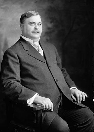
Charles Edward Magoon was an American lawyer, judge, diplomat, and administrator who is best remembered as a governor of the Panama Canal Zone; he also served as Minister to Panama at the same time. His successes led to his appointment as an occupation governor of Cuba in 1906. He was the subject of several scandals during his career. As a legal advisor working for the United States Department of War, he drafted recommendations and reports that were used by Congress and the executive branch in governing the United States' new territories following the Spanish–American War. These reports were collected as a published book in 1902, then considered the seminal work on the subject. During his time as a governor, Magoon worked to put these recommendations into practice. In summary: Magoon was hugely successful in Panama but criticized for his tenure in Cuba.

The Alto Velo Claim, also referred to as the Alta Vela Affair, was a territorial claim against the Dominican government by American adventurers ejected from Alto Velo Island by Dominican officials in October 1860. In all, three companies claimed U.S. protection of their right to mine guano from the island under the Guano Islands Act of 1856, but the U.S. Department of State never recognized U.S. interests in the island.

While the United States has relatively complicated maritime boundaries, it shares international land borders with only two nations:

<span class="mw-page-title-main">Lulu Town</span> Former human settlement on Navassa Island

Lulu Town, also known as Lulu Ville, is a now uninhabited, former settlement on Navassa Island, claimed by both the United States and neighbouring Haiti, in the Windward Passage.

Alto Velo Island is a small uninhabited island south of the island of Hispaniola in the Caribbean Sea. Its maximum height is about 152 metres (499 ft) above sea level. It lies on an underwater mountain range which continues to Beata Island and the southwestern coast of the Dominican Republic. It has an area of 1.02 km2 (0.39 sq mi) and is 1.4 km (0.87 mi) long, being oval in shape.

Sarah Ann Island is a vanished island, previously located at 4°0′N154°22′W. It was supposedly discovered in 1858 by Captain William W. Taylor and reported to the U.S. State Department on February 12, 1859, along with 41 other atolls and islands he claimed under the Guano Islands Act. Taylor assigned his interest in Sarah Ann Island and the other islands to the U.S. Guano Company of New York, which bonded them with the U.S. Treasury Department in February 1860; however, a 1933 review of Guano Islands Act claims found no evidence that the island was ever mined. Furthermore, the report noted that no island could be found at the reported coordinates of 4° 0' N, 154° 22' W.

Jones v. United States 137 U.S. 202 (1890) is a United States Supreme Court case in which the court upheld the constitutionality of the Guano Islands Act, which states that any island that fell under the act was under the jurisdiction of any existing statues or laws pertaining to high seas. The case originated from claims the United States government could not prosecute Henry Jones for committing murder on Navassa Island during a riot.

References

  1. "Formerly Disputed Islands". Office of Insular Affairs. 2007-01-11. Archived from the original on 2007-09-30. Retrieved 2009-09-09.
  2. "History: Under the American Flag". Office of Insular Affairs. 2006-01-30. Archived from the original on 2012-01-11. Retrieved 2009-09-09.
  3. Magoon 1900, p. 16.
  4. Skaggs, Jimmy M. (1994). The Great Guano Rush: Entrepreneurs and American Overseas Expansion. New York: St. Martin's Press. p. 213. ISBN   0-312-10316-6. OCLC   28506113..

Further reading