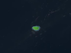
Niulakita

Last updated

Niulakita
Reef Island
Niulakita.png
Satellite picture
Niulakita 2022.png
Map of the island
Tuvalu location map.svg
Red pog.svg
Niulakita
Location in Tuvalu
Coordinates: 10°47′21″S179°28′23″E / 10.78917°S 179.47306°E / -10.78917; 179.47306
Country Tuvalu
Area
  Total0.40 km2 (0.15 sq mi)
Elevation
4.6 m (15.1 ft)
Population
 (2017)
  Total34
  Density85/km2 (220/sq mi)

Niulakita is the southernmost island of Tuvalu, [1] and also the name of the only village on this island. Niulakita has a population of 34 (2017 Census). [2] The residents of Niulakita have moved to the island from Niutao. Niulakita is represented in the Parliament of Tuvalu by the members of the constituency of Niutao.

Contents

History

The discovery of Niulakita is claimed by travellers from Nui, led by Kaunatu who was taking people home to Vaitupu, however their canoe drifted off course to the south and they arrived at Niulakita. There was only saltbrush ( Atriplex ) and pukavai trees ( Pisonia grandis ) on the islands. Kaeula, one of the passengers, died and was buried with the last of their coconuts planted at the head of his grave. The island was named by Kaunatu after a place of that name on Nui. [3]

The first sighting recorded by Europeans of Niulakita was on 29 August 1595 by the Spanish navigator Alvaro de Mendaña during his second expedition encountered Niulakita. The island was charted as 'La Solitaria' (Lonesome in Spanish). [4] [5] [6] An attempt was made to find a port with two small vessels in its southern part but the bottom was uneven and rocky and they abandoned their attempts. [7]

In 1821 Captain George Barrett, of the Nantucket whaler Independence II, visited Niulakita, which he named 'Rocky (Group)'. [5] This name was never much used, but 'Independence Island', after Barrett's ship, was one of the several names which came into general use for Niulakita during the 19th century. Niulakita was also known as 'Sophia'. [5]

In about 1879 the elders of Vaitupu were interested in Niulakita and send a working party to plant coconuts on the island. [8] However, in 1880 they were informed that J. C. Godeffroy und Sohn of Hamburg (operating out of Samoa) claimed ownership of the island. [8] Notwithstanding this claim in 1884 the Vaitupu elders transferred their claim to Niulakita to H. M. Ruge and Company, a German trading firm that operated from Apia, for $400 in part payment of a debt of $13,000 owed to the company. [9] Ruge & Co became insolvent in about 1888. On 15 April 1889 Niulakita was sold for $1,000 to Harry Jay Moors, an American citizen living in Apia, Samoa. [8] On 16 September 1896, Captain Herbert Gibson of HMS Curacoa, recorded in his journal that six men and six women, natives of various islands, were living on Niulakita working for Moors. Captain Gibson determined that the island was not under American protection so he hoisted the Union Jack and delivered the flag, with a copy of the Declaration of British Protectorate, to the headman of the working party. [8] [10]

In August 1896, the sailing ship Seladon of Stavanger was wrecked on the coral reef of Starbuck Island. The crew of 16 men were in the lifeboats with little food and water for 30 days, until they arrived at Niulakita. The crew were stranded for ten months until rescued by a passing steam ship. [11]

In 1914 Niulakita was purchased from Moors by the Samoa Shipping Trading Co Ltd, which was owned by Captain Ernest Frederick Hughes Allen. [12] It was bought by the Gilbert and Ellice Islands Colony administration in 1944. The administration gave people from Vaitupu permission to settle Niulakita. However, in 1949 a later administration decided to have Niulakita settled by the community from Niutao, which was considered to be overpopulated. The removal of the Vaitupuans was controversial. [13]

The United States asserted a claim to Niulakita under the Guano Islands Act of 1856; this claim was renounced under the 1983 treaty of friendship between Tuvalu and the United States. [14]

Geography

Niulakita is a reef island. [15] There are four ponds or lakes and the village has a maneapa (a community hall) in Tuvalu, which provides meeting and recreational functions as well. The isle has an oval outline, with the longer axis running east–west (about 1 km long). This island features highest point of Tuvalu (4.6 metres (15 ft) above sea level). A fringing reef surrounds the whole island, which makes local fishing and transport into and out of the island difficult.

Education

Niulakita's junior school is Lotoalofa Primary School.

See also

Related Research Articles

<span class="mw-page-title-main">Tuvalu</span> Country in Oceania

Tuvalu, formerly known as the Ellice Islands, is an island country in the Polynesian subregion of Oceania in the Pacific Ocean, about midway between Hawaii and Australia. It lies east-northeast of the Santa Cruz Islands, northeast of Vanuatu, southeast of Nauru, south of Kiribati, west of Tokelau, northwest of Samoa and Wallis and Futuna, and north of Fiji.

<span class="mw-page-title-main">Geography of Tuvalu</span> Overview of the geography of Tuvalu

The Western Pacific nation of Tuvalu, formerly known as the Ellice Islands, is situated 4,000 kilometers (2,500 mi) northeast of Australia and is approximately halfway between Hawaii and Australia. It lies east-northeast of the Santa Cruz Islands, southeast of Nauru, south of Kiribati, west of Tokelau, northwest of Samoa and Wallis and Futuna and north of Fiji. It is a very small island country of 26 km2 (10 sq mi). Due to the spread out islands it has the 38th largest Exclusive Economic Zone of 749,790 km2 (289,500 sq mi). In terms of size, it is the second-smallest country in Oceania.

<span class="mw-page-title-main">History of Tuvalu</span>

The first inhabitants of Tuvalu were Polynesians, so the origins of the people of Tuvalu can be traced to the spread of humans out of Southeast Asia, from Taiwan, via Melanesia and across the Pacific islands of Polynesia.

<span class="mw-page-title-main">Vaitupu</span> Atoll and one of nine districts of Tuvalu

Vaitupu is the largest atoll of the nation of Tuvalu. It is located at 7.48 degrees south and 178.83 degrees east. There are 1,061 people living on 5.6 square kilometres with the main village being Asau.

<span class="mw-page-title-main">Gilbert and Ellice Islands</span> 1892–1976 British colony in the Pacific

The Gilbert and Ellice Islands in the Pacific Ocean were part of the British Empire from 1892 to 1976. They were a protectorate from 1892 to 12 January 1916, and then a colony until 1 January 1976, and were administered as part of the British Western Pacific Territories (BWPT) until they became independent. The history of GEIC was mainly characterized by phosphate mining on Ocean Island. In October 1975, these islands were divided by force of law into two separate colonies, and they became independent nations shortly thereafter: the Ellice Islands became Tuvalu in 1978, and the Gilbert Islands became part of Kiribati in 1979.

<span class="mw-page-title-main">Nanumea</span> Atoll and one of nine districts of Tuvalu

Nanumea is the northwesternmost atoll in the Polynesian nation of Tuvalu, a group of nine coral atolls and islands spread over about 400 miles (640 km) of the Pacific Ocean just south of the equator and west of the International Date Line. Nanumea is 4 km2 (1.5 sq mi) with a population of 512 people.

<span class="mw-page-title-main">Nui (atoll)</span> Atoll and one of nine districts of Tuvalu

Nui is an atoll and one of nine districts of the Pacific Ocean state of Tuvalu. It has a land area of 3.37 km2 and a population of 610.

<span class="mw-page-title-main">Niutao</span> Reef island and one of nine districts of Tuvalu

Niutao is a reef island in the northern part of Tuvalu. It is one of the nine districts (islands) of Tuvalu. It is also one of the three districts that consist of only one island — not counting the three islets inside the closed lagoon. Niutao has a population of 582.

<span class="mw-page-title-main">Nukulaelae</span> Atoll and one of nine districts of Tuvalu

Nukulaelae is an atoll that is part of the nation of Tuvalu, and it has a population of 300. The largest settlement is Pepesala on Fangaua islet with a population of 300 people. It has the form of an oval and consists of at least 15 islets. The inhabited islet is Fangaua, which is 1.5 kilometres (0.93 mi) long and 50 to 200 metres wide. The easternmost point of Tuvalu is Niuoko islet. The Nukulaelae Conservation Area covers the eastern end of the lagoon. A baseline survey of marine life in the conservation zone was conducted in 2010.

<span class="mw-page-title-main">Nukufetau</span> Atoll and one of nine districts of Tuvalu

Nukufetau is an atoll that is part of the nation of Tuvalu. The atoll was claimed by the US under the Guano Islands Act some time in the 19th century and was ceded in a treaty of friendship concluded in 1979 and coming into force in 1983. It has a population of 597 who live on Savave islet.

<span class="mw-page-title-main">Tuvalu–United States relations</span> Bilateral relations

Tuvalu – United States relations are bilateral relations between Tuvalu and the United States.

<span class="mw-page-title-main">Outline of Tuvalu</span> Overview of and topical guide to Tuvalu

The following outline is provided as an overview of and topical guide to Tuvalu:

<span class="mw-page-title-main">Postage stamps and postal history of Tuvalu</span>

This is a survey of the postage stamps and postal history of Tuvalu.

<span class="mw-page-title-main">Timeline of the history of Tuvalu</span> Timeline of notable events in the history of Tuvalu

This timeline of the history of Tuvalu chronologically lists important events occurring within the present political boundaries of the Pacific island state of Tuvalu. This time line is introduced by the theories as to the origins of the Polynesian people and the migration across the Pacific Ocean to create Polynesia, which includes the islands of Tuvalu.

<span class="mw-page-title-main">Tuvaluan mythology</span>

Tuvaluan mythology tells stories of the creation of the islands of Tuvalu and of the founding ancestors of each island. While on some of the islands there are stories of spirits creating the islands, a creation story that is found on many of the islands is that te Pusi mo te Ali created the islands of Tuvalu; te Ali is believed to be the origin of the flat atolls of Tuvalu and te Pusi is the model for the coconut palms that are important in the lives of Tuvaluans. The strength of this belief has the consequence that Moray eel are tapu and are not eaten.

<span class="mw-page-title-main">Martin Kleis</span>

Christian Martin Kleis (1850–1908), known as Martin Kleis, was born in Denmark and died in the Ellice Islands (Tuvalu). Kleis was the resident trader on Nui in the late 19th century.

<span class="mw-page-title-main">Donald Gilbert Kennedy</span> British teacher and colonial official

Donald Gilbert Kennedy was a teacher, then an administrator in the British colonial service in the Gilbert and Ellice Islands Colony and the British Solomon Islands Protectorate. For his services as a Coastwatcher during the Pacific War, he was awarded the DSO, and the Navy Cross (U.S.). He published journal articles and books on the material culture of Vaitupu atoll, land tenure and the language of the Ellice Islands.

<span class="mw-page-title-main">Paopao (canoe)</span>

A paopao, is the name used by the Polynesian-speaking inhabitants of the Ellice Islands for their single-outrigger canoes, of which the largest could carry four to six adults. The large double-hulled sailing canoes had ceased to be constructed in the Ellice Islands some time before contact with Europeans.

<span class="mw-page-title-main">Tuvaluan nationality law</span>

Tuvaluan nationality law is regulated by the 1986 Constitution of Tuvalu, as amended; the 1979 Citizenship Ordinance, and its revisions; and various British Nationality laws. These laws determine who is, or is eligible to be, a national of Tuvalu. Tuvaluan nationality is typically obtained either on the principle of jus soli, i.e. by birth in Tuvalu or under the rules of jus sanguinis, i.e. by birth abroad to parents with Tuvaluan nationality. It can be granted to persons with an affiliation to the country, or to a permanent resident who has lived in the country for a given period of time through naturalisation. Nationality establishes one's international identity as a member of a sovereign nation. Though it is not synonymous with citizenship, for rights granted under domestic law for domestic purposes, the United Kingdom, and thus the Commonwealth, have traditionally used the words interchangeably.

References

  1. "Maps of Tuvalu" . Retrieved 15 January 2021.
  2. "Population of communities in Tuvalu". Thomas Brinkhoff. 2017. Retrieved 27 September 2020.
  3. Pape, Sotaga (1983). "Chapter 10 – Nui". In Laracy, Hugh (ed.). Tuvalu: A History. Institute of Pacific Studies, University of the South Pacific and Government of Tuvalu. p. 77.
  4. Maude, Islands and Men: Studies in Pacific History, Melbourne: Oxford University Press (1986) p.307
  5. 1 2 3 Keith S. Chambers & Doug Munro, The Mystery of Gran Cocal: European Discovery and Mis-Discovery in Tuvalu, 89(2) (1980) The Journal of the Polynesian Society, 167–198
  6. Laumua Kofe, Palagi and Pastors, Tuvalu: A History, Ch. 15, (U.S.P./Tuvalu)
  7. Maude, H.E. Spanish discoveries in the Central Pacific. A study in identification Journal of the Polynesian Society, Wellington, LXVIII, 1959, pp.306,307.
  8. 1 2 3 4 Roberts, R.G. (1958). Te Atu Tuvalu: A short history of the Ellice Islands. 67 (4) Journal of the Polynesian Society. pp. 196–197.
  9. Laupepa, Kalaaki (1983). "Chapter 11 – Vaitupu". In Laracy, Hugh (ed.). Tuvalu: A History. Institute of Pacific Studies, University of the South Pacific and Government of Tuvalu. p. 78.
  10. Laracy, Hugh, ed. (1983). "The 'Ownership' of Niulakita, 1880–1896". Tuvalu: A History. Institute of Pacific Studies, University of the South Pacific and Government of Tuvalu. pp. 196–197.
  11. Wincent Rege, Malvin Rege & Eli Rege (2012). The wreck of the Seladon: A true survival on an island story. CreateSpace. ISBN   978-1470002459.
  12. Laracy, Hugh (2013). "Ernest Frederick Hughes Allen (1867–1924): South Seas trader". Further Pacific Islands Portraits (Watriama and Co). p. 127-140. Retrieved 22 March 2024.
  13. "Foua Tofiga". tighar.org. Archived from the original on 2 February 2017. Retrieved 26 April 2015.
  14. "DOI Office of Insular Affairs (OIA) – FORMERLY DISPUTED ISLANDS". Doi.gov. Archived from the original on 30 September 2007. Retrieved 15 September 2009.
  15. British Admiralty Nautical Chart 766 Ellice Islands (1893 ed.). United Kingdom Hydrographic Office (UKHO). 21 March 1872.