Onslow County, North Carolina

Last updated

Onslow County
Onslow County Courthouse, North Carolina.jpg
Onslow County Courthouse
Onslow County Flag.gif
Onslow County Seal.png
Onslow County Logo.png
Map of North Carolina highlighting Onslow County.svg
Location within the U.S. state of North Carolina
North Carolina in United States.svg
North Carolina's location within the U.S.
Coordinates: 34°46′N77°30′W / 34.76°N 77.50°W / 34.76; -77.50
CountryFlag of the United States.svg United States
StateFlag of North Carolina.svg  North Carolina
Founded1734
Named for Arthur Onslow
Seat Jacksonville
Largest communityJacksonville
Area
  Total905.20 sq mi (2,344.5 km2)
  Land762.08 sq mi (1,973.8 km2)
  Water143.12 sq mi (370.7 km2)  15.81%
Population
 (2020)
  Total204,576
  Estimate 
(2023)
213,676
  Density268.44/sq mi (103.65/km2)
Time zone UTC−5 (Eastern)
  Summer (DST) UTC−4 (EDT)
Congressional district 3rd
Website www.onslowcountync.gov

Onslow County is a county located in the U.S. state of North Carolina. As of the 2020 census, the population was 204,576. [1] Its county seat is Jacksonville. [2] The county was created in 1734 as Onslow Precinct and gained county status in 1739. [3] Onslow County comprises the Jacksonville, NC Metropolitan Statistical Area. The southern border is the coast of the Atlantic Ocean.

Contents

History

European, mainly English, settlers arrived here in 1713 in what was originally part of the colonial precincts of Carteret and New Hanover. Onslow County was formed in 1734 and was named for Arthur Onslow, the longest serving speaker of the House of Commons. After a lethal 1752 hurricane, the county courthouse was relocated from Town Point to Wantland's Ferry; this settlement was eventually incorporated in 1842 and named Jacksonville after President Andrew Jackson. Through much of the first half of the 20th century, the county was largely rural, with an economy based on agrarian and maritime communities.

During World War II, Onslow County was dramatically changed in the early 1940s with the establishment of the United States Army Camp Davis near Holly Ridge (now defunct), and the creation of Camp Lejeune in 1941. This increased county population and generated related growth in housing and businesses.

Onslow County's flat, rolling terrain covers 767 square miles (1,990 km2) and is located in the southeastern coastal plain of North Carolina, about 120 miles (190 km) east of Raleigh and 50 miles (80 km) north of Wilmington. The city of Jacksonville is the county seat, and the areas surrounding the city constitute the major population centers and growth areas in the county. The county is home to more than 200,000 people and includes the incorporated towns of Holly Ridge, Richlands, Swansboro, North Topsail Beach, part of Surf City and unincorporated Sneads Ferry. The U.S. Marine Corps Base, Camp Lejeune, comprises roughly 156,000 acres (630 km2); more than 43,000 marines and sailors are stationed there.

Geography

Onslow County, North Carolina
Interactive map of Onslow County

According to the U.S. Census Bureau, the county has a total area of 905.20 square miles (2,344.5 km2), of which 762.08 square miles (1,973.8 km2) are land and 143.12 square miles (370.7 km2) (15.81%) are covered by water. [4] It is bordered by Jones County, Carteret County, Pender County, and Duplin County. [5]

Wildlife

The New River and its vicinity is sometimes inhabited by bald eagles, dolphins, and cownose rays. [6]

State and local protected areas

Major water bodies

Major highways

Major infrastructure

Demographics

Historical population
CensusPop.Note
1790 5,387
1800 5,6234.4%
1810 6,66918.6%
1820 7,0165.2%
1830 7,81411.4%
1840 7,527−3.7%
1850 8,28310.0%
1860 8,8566.9%
1870 7,569−14.5%
1880 9,82929.9%
1890 10,3034.8%
1900 11,94015.9%
1910 14,12518.3%
1920 14,7034.1%
1930 15,2894.0%
1940 17,93917.3%
1950 42,047134.4%
1960 82,70696.7%
1970 103,12624.7%
1980 112,7849.4%
1990 149,83832.9%
2000 150,3550.3%
2010 177,77218.2%
2020 204,57615.1%
2023 (est.)213,676 [1] 4.4%
U.S. Decennial Census [15]
1790–1960 [16] 1900–1990 [17]
1990–2000 [18] 2010 [19] 2020 [1]

2020 census

Onslow County racial composition [20]
RaceNumberPercentage
White (non-Hispanic)129,49965.7%
Black or African American (non-Hispanic)26,93915.8%
Native American 1,0190.5%
Asian 4,5082.2%
Pacific Islander 7770.38%
Other/Mixed 14,1936.94%
Hispanic or Latino 27,64112.9%

As of the 2020 census, there were 204,576 people, 63,604 households, and 46,202 families residing in the county.

2000 census

At the 2000 census, [21] 150,355 people, 48,122 households, and 36,572 families resided in the county. The population density was 196 people per square mile (76 people/km2). The 55,726 housing units averaged 73 units per square mile (28 units/km2). The racial makeup of the county was 72.06% White, 18.48% African American, 0.74% Native American, 1.68% Asian, 0.19% Pacific Islander, 3.62% from other races, and 3.22% from two or more races. About 7.25% of the population were Hispanic or Latino of any race.

Of the 48,122 households, 42.60% had children under the age of 18 living with them, 61.00% were married couples living together, 11.60% had a female householder with no husband present, and 24.00% were not families. About 18.60% of all households were made up of individuals, and 5.20% had someone living alone who was 65 years of age or older. The average household size was 2.72 and the average family size was 3.09.

In the county, the population was distributed as 26.20% under the age of 18, 23.80% from 18 to 24, 29.20% from 25 to 44, 14.40% from 45 to 64, and 6.30% who were 65 years of age or older. The median age was 25 years. For every 100 females, there were 123.20 males. For every 100 females age 18 and over, there were 131.30 males.

The median income for a household in the county was $33,756, and for a family was $36,692. Males had a median income of $22,061 versus $20,094 for females. The per capita income for the county was $14,853. About 10.80% of families and 12.90% of the population were below the poverty line, including 16.70% of those under age 18 and 14.70% of those age 65 or over.

Government and politics

Onslow is a typical "Solid South" county in its voting patterns. Except for the 1928 election, when anti-Catholic sentiment allowed Herbert Hoover to carry the county over Al Smith, it was solidly Democratic until 1968, during the FDR years by margins of as much as 13 to one in 1936. However, the 1960s onwards had Onslow turn to George Wallace in 1968 and then overwhelmingly to Richard Nixon over George McGovern in 1972. Since then, Onslow has become a strongly Republican county; the last Democrat to carry it was Jimmy Carter in 1976, and Carter in 1980 remains the last of his party to top 40%.

United States presidential election results for Onslow County, North Carolina [22] [23]
Year Republican Democratic Third party
No.%No.%No.%
2020 46,07863.79%24,26633.59%1,8912.62%
2016 37,12264.97%17,51430.65%2,4994.37%
2012 32,24362.69%18,49035.95%7021.36%
2008 30,27860.31%19,49938.84%4260.85%
2004 25,89069.45%11,25030.18%1370.37%
2000 19,65765.06%10,26933.99%2890.96%
1996 13,39655.70%8,68536.11%1,9688.18%
1992 11,84248.70%8,04533.08%4,43118.22%
1988 12,25362.87%7,16236.75%730.37%
1984 13,92870.75%5,71329.02%460.23%
1980 8,86152.95%7,37144.04%5043.01%
1976 5,95342.61%7,95456.94%630.45%
1972 10,34380.05%2,42418.76%1541.19%
1968 3,44428.08%3,28126.75%5,54245.18%
1964 3,77138.77%5,95561.23%00.00%
1960 2,81233.57%5,56466.43%00.00%
1956 1,62625.74%4,69274.26%00.00%
1952 1,26122.78%4,27577.22%00.00%
1948 3168.32%3,31887.34%1654.34%
1944 43313.77%2,71186.23%00.00%
1940 27110.21%2,38389.79%00.00%
1936 2357.85%2,75892.15%00.00%
1932 2538.79%2,61590.89%90.31%
1928 1,25353.89%1,07246.11%00.00%
1924 42326.84%1,12271.19%311.97%
1920 85335.39%1,55764.61%00.00%
1916 78539.53%1,19760.27%40.20%
1912 664.35%90159.39%55036.26%
1908 71044.94%87055.06%00.00%
1904 45133.78%82862.02%564.19%
1900 61831.86%1,32268.14%00.00%
1896 58927.42%1,55972.58%00.00%
1892 37919.42%1,13758.25%43622.34%
1888 45327.79%1,17772.21%00.00%
1884 50428.06%1,29271.94%00.00%
1880 53733.11%1,08566.89%00.00%

Onslow County is a member of the regional Eastern Carolina Council of Governments.

The structure of local government in Onslow County was changed in 2016 to have seven commissioners in 2018 board of commissioners, all elected at-large for four-year terms. In contrast to electing members from districts, this structure means that candidates are elected by the majority population in the county, which gives a more accurate view of the entire electorate. On November 8, 2016, citizens voted in favor to alter the number of commissioners from five commissioners with concurrent terms to seven with staggered terms. In 2018, citizens elected two more county commissioners in the general election on November 6, 2018, to four-year terms. The citizens of the county will elect five commissioners in 2020, but the four candidates who receive the highest number of votes in the general election of 2020 will receive a four-year term and the candidate who receives the fifth-highest number of votes in the general election of 2020 to a two-year term. Thereafter, all county commissioners would be elected to serve four-year terms. The board establishes policies and ordinances implemented by the county manager and his staff. Commissioners are Jack Bright (chair), Royce Bennett (vice chair), Paul Buchanan, Robin Knapp, Mark Price, Tim Foster, and William Shanahan.

In the North Carolina Senate, Onslow County is located in the 6th Senate district, which is represented by Republican Michael Lazzara. In the North Carolina House of Representatives, Onslow County is split into three House districts with the 14th and 15th house districts completely in Onslow County and the 16th House district in part of Onslow County and all of neighboring Pender County. The 14th district is represented by Republican George Cleveland, the 15th district is represented by Republican Phil Shepard, and the 16th district is represented by Republican Carson Smith. [24]

The main law enforcement agency for Onslow County is the County Sheriff's Department. The elected sheriff is Chris Thomas. [25]

Education

Onslow County Schools serves the county, except for Camp Lejeune and Marine Corps Air Station New River, which are served by Department of Defense Education Activity (DoDEA) schools. [26]

Communities

Map of Onslow County with municipal and township labels Map of Onslow County North Carolina With Municipal and Township Labels.PNG
Map of Onslow County with municipal and township labels

Incorporated communities

Unincorporated communities

Census-designated places

Townships

Camp Lejeune and Hofmann Forest are classified as unorganized territories instead of townships. [27] [28]

See also

Related Research Articles

<span class="mw-page-title-main">Pender County, North Carolina</span> County in North Carolina, United States

Pender County is a county located in the U.S. state of North Carolina. As of the 2020 census, the population was 60,203. Its county seat is Burgaw. Pender County is part of the Wilmington, NC Metropolitan Statistical Area.

<span class="mw-page-title-main">Jones County, North Carolina</span> County in North Carolina, United States

Jones County is a county located in the U.S. state of North Carolina. As of the 2020 census, the population was 9,172, making it the fourth-least populous county in North Carolina. Its county seat is Trenton. Jones County is part of the New Bern, NC Micropolitan Statistical Area.

<span class="mw-page-title-main">Durham County, North Carolina</span> County in North Carolina, United States

Durham County is a county located in the U.S. state of North Carolina. As of the 2020 census, the population was 324,833, making it the sixth-most populous county in North Carolina. Its county seat is Durham, which is the only incorporated municipality predominantly in the county, though very small portions of cities and towns mostly in neighboring counties also extend into Durham County. The central and southern parts of Durham County are highly urban, consisting of the city as well as several unincorporated suburbs. Southeastern Durham County is dominated by the Research Triangle Park, most of which is in Durham County. The northern third of Durham County is rural in nature.

<span class="mw-page-title-main">Carteret County, North Carolina</span> County in North Carolina, United States

Carteret County is a county located in the U.S. state of North Carolina. As of the 2020 census, the population was 67,686. Its county seat is Beaufort. The county was created in 1722 as Carteret Precinct and gained county status in 1739. It was named for Sir George Carteret, one of the 17th century English Lords Proprietor, or for his descendant and heir John Carteret, 2nd Earl Granville.

<span class="mw-page-title-main">Brunswick County, North Carolina</span> County in North Carolina, United States

Brunswick County is a county located in the U.S. state of North Carolina. It is the southernmost county in the state. As of the 2020 census, the population was 136,693. Its population was only 73,143 in 2000, making it one of the fastest-growing counties in the state. With a nominal growth rate of approximately 47% in ten years, much of the growth is centered in the eastern section of the county in the suburbs of Wilmington such as Leland, Belville and Southport. The county seat is Bolivia, which at a population of around 150 people is among the least populous county seats in the state.

<span class="mw-page-title-main">Beaufort County, North Carolina</span> County in North Carolina, United States

Beaufort County is a county located in the U.S. state of North Carolina. As of the 2020 census, the population was 44,652. Its county seat is Washington. The county was founded in 1705 as Pamptecough Precinct. Originally included in Bath County, it was renamed Beaufort Precinct in 1712 and became Beaufort County in 1739.

<span class="mw-page-title-main">Cedar Point, North Carolina</span> Town in North Carolina, United States

Cedar Point is a town in Carteret County, North Carolina, United States. The population was 1,297 in 2010.

<span class="mw-page-title-main">Morehead City, North Carolina</span> Town in North Carolina, United States

Morehead City is a port town in Carteret County, North Carolina, United States. The population was 8,661 at the 2010 census. Morehead City celebrated the 150th anniversary of its founding on May 5, 2007. It forms part of the Crystal Coast.

<span class="mw-page-title-main">Holly Ridge, North Carolina</span> Town in North Carolina, United States

Holly Ridge is a town in Onslow County, North Carolina, United States. The 2010 population was 1,268. The 2020 census population was 4,171. It is part of the Jacksonville, North Carolina Metropolitan Statistical Area. It is considered the gateway to Topsail Island.

<span class="mw-page-title-main">Jacksonville, North Carolina</span> City in North Carolina, United States

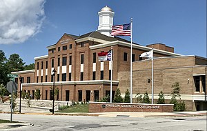
Jacksonville is a city in Onslow County, North Carolina, United States. As of the 2020 census, the population was 72,723, which makes Jacksonville the 14th-most populous city in North Carolina. Jacksonville is the county seat and most populous community of Onslow County, which is coterminous with the Jacksonville, NC Metropolitan Statistical Area. Demographically, Jacksonville is the youngest city in the United States, with an average age of 22.8 years old, which can be attributed to the large military presence. The low age may also be in part due to the population drastically going up over the past 80 years, from 783 in the 1930 census to 72,723 in the 2020 census.

<span class="mw-page-title-main">Richlands, North Carolina</span> Town in North Carolina, United States

Richlands is a town in Onslow County, North Carolina, United States. In the 2020 U.S. census, the population was 2,287. It is included in the Jacksonville, North Carolina Metropolitan Statistical Area. Incorporated on March 29, 1880, it was the first town in Onslow County to have its own library and museum. Richlands was also the first town in Onslow County to have a female mayor, Annette Hargett.

<span class="mw-page-title-main">Sneads Ferry, North Carolina</span> CDP in North Carolina, United States

Sneads Ferry is a census-designated place (CDP) in Onslow County, North Carolina, United States. It is the second largest municipality in Onslow County, behind Jacksonville and is part of the Jacksonville, North Carolina Metropolitan Statistical Area. Once a rural fishing village, Sneads Ferry has experienced a surge in development since 2000. Based on U.S. Census data, the study area has grown from 5,425 residents in 2000 to approximately 9,750 residents in 2014, an 80% increase. Growth primarily has been driven by accessibility to MCB Camp Lejeune from the gate on NC 172 and expansion of the United States Marine Corps Special Operations Command (MARSOC) accessed from NC 210. Sneads Ferry is expected to continue growing rapidly at 3.3% annually, adding 17,500 new residents through 2040 reaching 20,000 in total population by 2030.

<span class="mw-page-title-main">Swansboro, North Carolina</span> Town in North Carolina, United States

Swansboro is a town in Onslow County, North Carolina, United States, located along the Crystal Coast. In 2020, the population was 3,744.

<span class="mw-page-title-main">Hammocks Beach State Park</span> State park in North Carolina, United States

Hammocks Beach State Park is a North Carolina state park in Onslow County, North Carolina in the United States. Located near Swansboro, along the Southern Outer Banks, or Crystal Coast, the state park covers 1,611 acres (6.52 km2) and consists mainly of Bear Island. The park also owns three smaller islands, Dudley, Huggins and Jones, located in the nearby mouth of the White Oak River. After a recently completed deal, 319 acres (1.29 km2) acres on the mainland were added to the park.

<span class="mw-page-title-main">Marine Corps Base Camp Lejeune</span> Marine Corps base in North Carolina, US

Marine Corps Base Camp Lejeune is a 246-square-mile (640-square-kilometer) United States military training facility in Jacksonville, North Carolina. Its 14 miles of beaches make the base a major area for amphibious assault training, and its location between two deep-water ports allows for fast deployments. The main base is supplemented by six satellite facilities: Marine Corps Air Station New River, Camp Geiger, Stone Bay, Courthouse Bay, Camp Johnson, and the Greater Sandy Run Training Area. The Marine Corps port facility is in Beaufort, at the southern tip of Radio Island. It is occupied only during military port operations.

<span class="mw-page-title-main">North Carolina Highway 24</span> State highway in North Carolina, US

North Carolina Highway 24 (NC 24) is the longest primary state highway in the U.S. state of North Carolina. It travels east–west between the Charlotte metropolitan area and the Crystal Coast, connecting the cities of Charlotte, Fayetteville, Jacksonville and Morehead City.

<span class="mw-page-title-main">Verona, North Carolina</span> CDP in North Carolina, United States

Verona is a small town in rural Onslow County, on the outskirts of Jacksonville, North Carolina, United States. It is located off U.S. Route 17, seven miles (11 km) to the south of Jacksonville, and ten miles (16 km) to the north of Holly Ridge. Verona is bordered by Highway 17 to the east, Verona Rd. to the north, and High Hill Rd. to the South. High Hill and Verona Rds. intersect to form the western boundary. The population of Verona in the 2000 census was approximately 178 people. The demographic breakdown was: Caucasian: 86%, Hispanic: 9%, African-American: < 5%, Other: < 2%.

Hubert is an unincorporated community in the eastern portion of Onslow County, North Carolina, United States, near the city of Swansboro. Hubert is part of the Jacksonville Metropolitan Statistical Area. The community is located on the northeast side of Marine Corps Base Camp Lejeune. The ZIP code for Hubert is 28539. Hubert’s main roads are Freedom Way, Hubert Boulevard, Sand Ridge Road, Riggs Road, and Queens Creek Road.

The Daily News is an American, English language daily newspaper headquartered in Jacksonville, North Carolina. It has served the city of Jacksonville, Marine Corps Base Camp Lejeune, and the surrounding parts of Onslow County including, Richlands, Swansboro, Sneads Ferry, Holly Ridge, and North Topsail since 1953.

Onslow County Schools (OSC) is a school district headquartered in Jacksonville, North Carolina.

References

  1. 1 2 3 "QuickFacts: Onslow County, North Carolina". United States Census Bureau. Retrieved March 21, 2024.
  2. "Find a County". National Association of Counties. Retrieved June 7, 2011.
  3. "North Carolina: Individual County Chronologies". North Carolina Atlas of Historical County Boundaries. The Newberry Library. 2009. Archived from the original on March 4, 2016. Retrieved January 25, 2015.
  4. "2020 County Gazetteer Files – North Carolina". United States Census Bureau. August 23, 2022. Retrieved September 9, 2023.
  5. "Onslow County, North Carolina". U.S. Census Bureau . Retrieved March 14, 2022.
  6. Wall, Julia (March 14, 2023). "An Oyster Highway Is the New River's Future". The Assembly. Retrieved March 14, 2023.
  7. 1 2 "Outstanding Resource Waters" (PDF). files.nc.gov. July 1, 2009. Archived (PDF) from the original on August 31, 2020. Retrieved July 27, 2022.
  8. 1 2 3 4 "NCWRC Game Lands". www.ncpaws.org. Retrieved March 30, 2023.
  9. Am; Rodriguez, a (March 27, 2015). "Is Hofmann Forest Safe?". www.dogwoodalliance.org. Retrieved July 27, 2022.
  10. "Permuda Island Reserve". www.deq.nc.gov. Retrieved April 6, 2023.
  11. 1 2 "North Carolina Department of Environmental and Natural Resources Division of Marine Fisheries" (PDF). www.nrc.gov. July 1, 2006. Archived (PDF) from the original on March 22, 2017. Retrieved July 27, 2022.
  12. 1 2 "Strategic Habitat Area Nominations for Region 3: The White Oak River Basin in North Carolina". deq.nc.gov. November 2014. Retrieved July 27, 2022.
  13. "Queen Creek (in Onslow County, NC)". northcarolina.hometownlocator.com. Retrieved July 27, 2022.
  14. "Stones Bay (in Onslow County, NC)". northcarolina.hometownlocator.com. Retrieved May 11, 2023.
  15. "U.S. Decennial Census". United States Census Bureau. Retrieved January 18, 2015.
  16. "Historical Census Browser". University of Virginia Library. Retrieved January 18, 2015.
  17. Forstall, Richard L., ed. (March 27, 1995). "Population of Counties by Decennial Census: 1900 to 1990". United States Census Bureau. Retrieved January 18, 2015.
  18. "Census 2000 PHC-T-4. Ranking Tables for Counties: 1990 and 2000" (PDF). United States Census Bureau. April 2, 2001. Archived (PDF) from the original on March 27, 2010. Retrieved January 18, 2015.
  19. "State & County QuickFacts". United States Census.[ permanent dead link ]
  20. "Explore Census Data". data.census.gov. Retrieved December 24, 2021.
  21. "U.S. Census website". United States Census Bureau . Retrieved January 31, 2008.
  22. Leip, David. "Dave Leip's Atlas of U.S. Presidential Elections". uselectionatlas.org. Retrieved March 16, 2018.
  23. "Géographie électorale". geoelections.free.fr (in French). Archived from the original on November 18, 2005. Retrieved January 13, 2021.
  24. "DRA 2020". Daves Redistricting. Retrieved April 19, 2022.
  25. "Sheriff Christopher D. Thomas". www.onslowcountync.gov. Retrieved September 2, 2023.
  26. "2020 CENSUS - SCHOOL DISTRICT REFERENCE MAP: Onslow County, NC" (PDF). U.S. Census Bureau. Archived (PDF) from the original on July 5, 2022. Retrieved July 5, 2022. - Text list - "Camp Lejeune Schools" refers to the DoDEA schools.
  27. "Census profile: Camp Lejeune UT, Onslow County, NC". Census Reporter. Retrieved April 18, 2023.
  28. "Census profile: Hofmann Forest UT, Onslow County, NC". Census Reporter. Retrieved April 18, 2023.