Half Moon, North Carolina

Last updated

Half Moon, North Carolina
CDP
NCMap-doton-HalfMoon.PNG
Location of Half Moon, North Carolina
Coordinates: 34°49′47″N77°27′33″W / 34.82972°N 77.45917°W / 34.82972; -77.45917
CountryUnited States
State North Carolina
County Onslow
Area
[1]
  Total7.42 sq mi (19.22 km2)
  Land7.42 sq mi (19.22 km2)
  Water0.00 sq mi (0.00 km2)
Elevation
[2]
33 ft (10 m)
Population
 (2020)
  Total7,543
  Density1,016.44/sq mi (392.44/km2)
Time zone UTC-5 (Eastern (EST))
  Summer (DST) UTC-4 (EDT)
FIPS code 37-28900 [3]
GNIS feature ID2402561 [2]

Half Moon is a census-designated place (CDP) in Onslow County, North Carolina, United States. The population was 6,645 at the 2000 census. It is part of the Jacksonville, North Carolina Metropolitan Statistical Area.

Contents

Geography

According to the United States Census Bureau, the CDP has a total area of 4.3 square miles (11 km2), all land.

Demographics

Historical population
CensusPop.Note
2020 7,543
U.S. Decennial Census [4]

2020 census

Half Moon racial composition [5]
RaceNumberPercentage
White (non-Hispanic)4,10054.36%
Black or African American (non-Hispanic)1,58020.95%
Native American 460.61%
Asian 1832.43%
Pacific Islander 490.65%
Other/Mixed 6748.94%
Hispanic or Latino 91112.08%

As of the 2020 United States census, there were 7,543 people, 2,769 households, and 2,027 families residing in the CDP.

2000 census

As of the census [3] of 2000, there were 6,645 people, 2,261 households, and 1,817 families residing in the CDP. The population density was 1,548.1 inhabitants per square mile (597.7/km2). There were 2,398 housing units at an average density of 558.7 per square mile (215.7/km2). The racial makeup of the CDP was 65.13% White, 24.47% African American, 0.57% Native American, 2.59% Asian, 0.17% Pacific Islander, 2.75% from other races, and 4.32% from two or more races. Hispanic or Latino of any race were 6.71% of the population.

There were 2,261 households, out of which 47.3% had children under the age of 18 living with them, 64.0% were married couples living together, 13.6% had a female householder with no husband present, and 19.6% were non-families. 14.0% of all households were made up of individuals, and 2.2% had someone living alone who was 65 years of age or older. The average household size was 2.94 and the average family size was 3.22.

In the CDP, the population was spread out, with 32.4% under the age of 18, 12.7% from 18 to 24, 33.8% from 25 to 44, 17.1% from 45 to 64, and 4.0% who were 65 years of age or older. The median age was 28 years. For every 100 females, there were 98.2 males. For every 100 females age 18 and over, there were 95.4 males.

The median income for a household in the CDP was $41,143, and the median income for a family was $42,357. Males had a median income of $27,730 versus $20,698 for females. The per capita income for the CDP was $15,233. About 5.9% of families and 7.7% of the population were below the poverty line, including 11.1% of those under age 18 and 8.1% of those age 65 or over.

Related Research Articles

<span class="mw-page-title-main">Rock Creek, Alabama</span> CDP in Alabama, United States

Rock Creek is a census-designated place in Jefferson County, Alabama, United States. Its location is northwest of Hueytown. At the 2020 census, the population was 1,471. This area was damaged by an F5 tornado on April 8, 1998. An EF2 tornado struck northwest from here on January 23, 2012.

<span class="mw-page-title-main">Pine Hills, California</span> Census-designated place in California, United States

Pine Hills is a census-designated place (CDP) in Humboldt County, California, United States, adjacent to Eureka. The population was 3,131 at the 2010 census, up from 3,108 at the 2000 census. Pine Hills includes areas like Ridgewood and areas as far south as the small neighborhood of Elk River. An area near this artificial census construct is called Pine Hill by Local government agencies and officials. Pine Hill is a much smaller area than "Pine Hills" and as defined by local agencies is actually within an adjacent CDP named Bayview.

<span class="mw-page-title-main">Dixon Lane-Meadow Creek, California</span> Census-designated place in California, United States

Dixon Lane-Meadow Creek is a census-designated place (CDP) in Inyo County, California, United States. The population was 2,645 at the 2010 census, down from 2,702 at the 2000 census.

Heritage Village is a census-designated place (CDP) in the town of Southbury in New Haven County, Connecticut, United States. The population was 3,736 at the 2010 census.

<span class="mw-page-title-main">Highland, Vanderburgh County, Indiana</span> Census-designated place in Indiana, United States

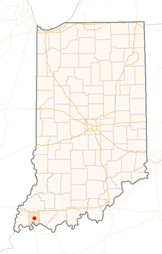
Highland is a census-designated place (CDP) in Center Township, Vanderburgh County, in the U.S. state of Indiana. The population was 4,489 at the 2010 census.

<span class="mw-page-title-main">Lemay, Missouri</span> CDP in Missouri, United States

Lemay is a census-designated place (CDP) in south St. Louis County, Missouri, United States. The population was 16,645 at the 2010 census.

<span class="mw-page-title-main">Butters, North Carolina</span> Census-designated place in North Carolina, United States

Butters is a census-designated place (CDP) in Bladen County, North Carolina, United States. As of the 2010 census, the population was 294.

Brices Creek is an unincorporated area and census-designated place (CDP) in Craven County, North Carolina, United States. The population was 3,073 at the 2010 census. It is part of the New Bern, North Carolina Metropolitan Statistical Area.

<span class="mw-page-title-main">White Plains, North Carolina</span> CDP in North Carolina, United States

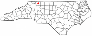
White Plains is a census-designated place (CDP) in Surry County, North Carolina, United States. The population was 1,049 at the 2000 census.

<span class="mw-page-title-main">Russellton, Pennsylvania</span> Census-designated place in Pennsylvania, United States

Russellton is a census-designated place (CDP) in Allegheny County, Pennsylvania, United States. The population was 1,330 at the 2020 census.

<span class="mw-page-title-main">Lenape Heights, Pennsylvania</span> Census-designated place in Pennsylvania, United States

Lenape Heights is a census-designated place (CDP) in Armstrong County, Pennsylvania, United States. The population was 1,144 at the 2020 census.

<span class="mw-page-title-main">Hyde, Pennsylvania</span> Census-designated place in Pennsylvania, United States

Hyde is an unincorporated community and census-designated place (CDP) in Clearfield County, Pennsylvania, United States. The population was 1,303 at the 2020 census.

Ravine is a census-designated place (CDP) in Schuylkill County, Pennsylvania, United States. The population was 629 at the 2000 census.

<span class="mw-page-title-main">North Hartsville, South Carolina</span> Census-designated place in South Carolina, United States

North Hartsville is a census-designated place (CDP) in Darlington County, South Carolina, United States. The population was 3,251 at the 2010 census. It is part of the Florence Metropolitan Statistical Area and the Hartsville Urban Cluster.

Wade Hampton is a census-designated place (CDP) in Greenville County, South Carolina, United States. The population was 20,622 at the 2010 census. It is named for American Civil War general and South Carolina governor Wade Hampton.

<span class="mw-page-title-main">Inman Mills, South Carolina</span> CDP in South Carolina, United States

Inman Mills is a census-designated place (CDP) in Spartanburg County, South Carolina, United States. The population was 1,050 at the 2010 census.

<span class="mw-page-title-main">Lake Wazeecha, Wisconsin</span> CDP in Wisconsin, United States

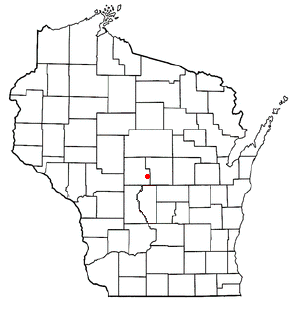
Lake Wazeecha is a census-designated place (CDP) in the town of Grand Rapids, Wood County, Wisconsin, United States. The population was 2,651 at the 2010 census.

Howland is a census-designated place (CDP) in Penobscot County, Maine, United States. The population was 1,096 at the 2010 census.

<span class="mw-page-title-main">Holland (CDP), New York</span> Census-designated place in New York, United States

Holland is a hamlet and census-designated place (CDP) in Erie County, New York, United States. The population was 1,206 at the 2010 census. It is in the town of Holland and is part of the Buffalo–Niagara Falls Metropolitan Statistical Area.

Duncott is a census-designated place (CDP) in Schuylkill County, Pennsylvania, United States, near Minersville in the Coal Region. The population was 76 at the 2000 census. It is located in Cass Township.

References

  1. "ArcGIS REST Services Directory". United States Census Bureau. Retrieved September 20, 2022.
  2. 1 2 U.S. Geological Survey Geographic Names Information System: Half Moon, North Carolina
  3. 1 2 "U.S. Census website". United States Census Bureau . Retrieved January 31, 2008.
  4. "Census of Population and Housing". Census.gov. Retrieved June 4, 2016.
  5. "Explore Census Data". data.census.gov. Retrieved December 24, 2021.