Piney Green, North Carolina

Last updated

Piney Green, North Carolina
CDP
NCMap-doton-PineyGreen.PNG
Location of Piney Green, North Carolina
Coordinates: 34°44′59″N77°19′15″W / 34.74972°N 77.32083°W / 34.74972; -77.32083
Country United States
State North Carolina
County Onslow
Area
[1]
  Total13.72 sq mi (35.54 km2)
  Land13.63 sq mi (35.30 km2)
  Water0.09 sq mi (0.24 km2)
Elevation
[2]
3 ft (0.9 m)
Population
 (2020)
  Total14,386
  Density1,055.39/sq mi (407.48/km2)
Time zone UTC-5 (Eastern (EST))
  Summer (DST) UTC-4 (EDT)
FIPS code 37-52260 [3]
GNIS feature ID2403422 [2]

Piney Green is a census-designated place (CDP) in Onslow County, North Carolina, United States. The population was 11,658 at the 2000 census. It is part of the Jacksonville, North Carolina Metropolitan Statistical Area.

Contents

Geography

According to the United States Census Bureau, the CDP has a total area of 13.5 square miles (35 km2), of which 13.4 square miles (35 km2) is land and 0.1 square miles (0.26 km2) (0.37%) is water.

Demographics

Historical population
CensusPop.Note
2020 14,386
U.S. Decennial Census [4]

2020 census

Piney Green racial composition [5]
RaceNumberPercentage
White (non-Hispanic)7,43951.71%
Black or African American (non-Hispanic)2,86719.93%
Native American 650.45%
Asian 3752.61%
Pacific Islander 470.33%
Other/Mixed 1,3179.15%
Hispanic or Latino 2,27615.82%

As of the 2020 United States census, there were 14,386 people, 4,742 households, and 3,430 families residing in the CDP.

2000 census

At the 2000 census, [3] there were 148,658 people, 4,202 households, and 3,193 families residing in the CDP. The population density was 868.7 inhabitants per square mile (335.4/km2). There were 4,671 housing units at an average density of 348.1 per square mile (134.4/km2). The racial makeup of the CDP was 64.74% White, 24.56% African American, 0.75% Native American, 2.58% Asian, 0.25% Pacific Islander, 3.12% from other races, and 4.01% from two or more races. Hispanic or Latino of any race were 7.61% of the population.

There were 5,126 households, out of which 43.5% had children under the age of 18 living with them, 60.2% were married couples living together, 12.6% had a female householder with no husband present, and 24.0% were non-families. 17.8% of all households were made up of individuals, and 2.7% had someone living alone who was 65 years of age or older. The average household size was 2.77 and the average family size was 3.12.

In the CDP, the population was spread out, with 30.2% under the age of 18, 16.0% from 18 to 24, 33.6% from 25 to 44, 15.6% from 45 to 64, and 4.5% who were 65 years of age or older. The median age was 27 years. For every 100 females, there were 98.0 males. For every 100 females age 18 and over, there were 96.2 males.

The median income for a household in the CDP was $36,636, and the median income for a family was $40,117. Males had a median income of $27,994 versus $20,278 for females. The per capita income for the CDP was $15,353. About 7.3% of families and 10.5% of the population were below the poverty line, including 13.9% of those under age 18 and 15.4% of those age 65 or over.

Related Research Articles

<span class="mw-page-title-main">Kachina Village, Arizona</span> CDP in Coconino County, Arizona

Kachina Village is a census-designated place (CDP) in Coconino County, Arizona, United States. The population was 2,622 at the 2010 census. Kachina Village is primarily a bedroom community for Flagstaff.

<span class="mw-page-title-main">Piney, Garland County, Arkansas</span> CDP in Arkansas, United States

Piney is a census-designated place (CDP) in Garland County, Arkansas, United States. The population was 4,699 at the 2010 census.

<span class="mw-page-title-main">Concordia, New Jersey</span> Populated place in Middlesex County, New Jersey, US

Concordia is an unincorporated community and census-designated place (CDP) located within Monroe Township, in Middlesex County, in the U.S. state of New Jersey. The CDP is oriented around the age restricted gated community of Concordia. As of the 2010 United States Census, the CDP's population was 3,092.

<span class="mw-page-title-main">Woodlawn, North Carolina</span> Census-designated place in North Carolina, United States

Woodlawn is a census-designated place in Alamance County, North Carolina, United States.

<span class="mw-page-title-main">White Plains, North Carolina</span> CDP in North Carolina, United States

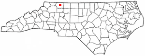
White Plains is a census-designated place (CDP) in Surry County, North Carolina, United States. The population was 1,049 at the 2000 census.

<span class="mw-page-title-main">Hilltop, Ohio</span> Census-designated place in Ohio, United States

Hilltop is an unincorporated community and census-designated place in central Weathersfield Township, Trumbull County, Ohio, United States. The population was 658 at the 2020 census. It is part of the Youngstown–Warren metropolitan area.

<span class="mw-page-title-main">Sandy, Pennsylvania</span> Census-designated place in Pennsylvania, United States

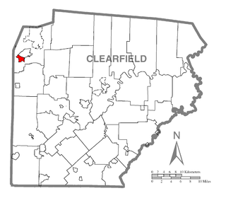
Sandy is a census-designated place (CDP) in Clearfield County, Pennsylvania, United States. The population was 1,362 at the 2020 census.

<span class="mw-page-title-main">Berea, South Carolina</span> CDP in South Carolina, United States

Berea is a census-designated place (CDP) in Greenville County, South Carolina, United States. The population was 14,295 at the 2010 census. It is part of the Greenville–Mauldin–Easley Metropolitan Statistical Area.

Wade Hampton is a census-designated place (CDP) in Greenville County, South Carolina, United States. The population was 20,622 at the 2010 census. It is named for American Civil War general and South Carolina governor Wade Hampton.

<span class="mw-page-title-main">Red Hill, South Carolina</span> Census-designated place in South Carolina, United States

Red Hill is a census-designated place (CDP) in Horry County, South Carolina, United States. The population was 13,223 at the 2010 census, up from 10,509 at the 2000 census.

Seven Oaks is a census-designated place (CDP) in Lexington County, South Carolina, United States, 8 miles (13 km) northwest of downtown Columbia, the state capital. The population of the CDP was 15,144 at the 2010 census. It is part of the Columbia Metropolitan Statistical Area.

<span class="mw-page-title-main">Dentsville, South Carolina</span> Census-designated place in South Carolina, United States

Dentsville is a census-designated place (CDP) in Richland County, South Carolina, United States. The population was 14,062 at the 2010 census. It is part of the Columbia, South Carolina, Metropolitan Statistical Area.

Shiloh is a census-designated place (CDP) in Sumter County, South Carolina, United States. The population was 259 at the 2000 census. It is included in the Sumter, South Carolina Metropolitan Statistical Area.

<span class="mw-page-title-main">India Hook, South Carolina</span> CDP in South Carolina, United States

India Hook is a census-designated place (CDP) in York County, South Carolina, United States. The majority of India Hook is annexed into the city of Rock Hill, but as of 2010 India Hook is still considered to be a CDP. It is one of the three communities located on Lake Wylie.

<span class="mw-page-title-main">Del Mar Heights, Texas</span> Census-designated place in Texas, United States

Del Mar Heights is a census-designated place (CDP) in Cameron County, Texas, United States. The population was 113 at the 2010 census. It is part of the Brownsville–Harlingen Metropolitan Statistical Area.

<span class="mw-page-title-main">Chula Vista, Maverick County, Texas</span> CDP in Texas, United States

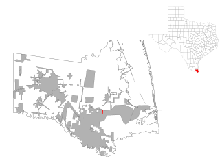
Chula Vista, formerly known as Rosita North, is a census-designated place (CDP) in Maverick County, Texas, United States. The population was 3,400 at the 2000 census.

<span class="mw-page-title-main">East Wenatchee Bench, Washington</span> Former CDP in Washington, United States

East Wenatchee Bench is a former census-designated place in Douglas County, Washington, United States. Most of the area has been annexed by the city of East Wenatchee. It was part of the Wenatchee–East Wenatchee Metropolitan Statistical Area. The population was 13,658 at the 2000 census, but it was no longer a CDP in the 2010 census.

<span class="mw-page-title-main">Piney View, West Virginia</span> Census-designated place in West Virginia, United States

Piney View is a census-designated place (CDP) in Raleigh County, West Virginia, United States. The population was 989 at the 2010 census.

<span class="mw-page-title-main">Calpet, Wyoming</span> Unincorporated community in Wyoming, United States

Calpet is an unincorporated community in Sublette County, Wyoming, United States. The population was 7 at the 2000 census, when it was a census-designated place (CDP).

<span class="mw-page-title-main">Loveland Park, Ohio</span> Census-designated place in Ohio, United States

Loveland Park is a census-designated place (CDP) located in Symmes Township, Hamilton County and Deerfield Township, Warren County, in the southwestern part of the U.S. state of Ohio. The CDP is named after the city of Loveland. The population was 1,737 at the 2020 census.

References

  1. "ArcGIS REST Services Directory". United States Census Bureau. Retrieved September 20, 2022.
  2. 1 2 U.S. Geological Survey Geographic Names Information System: Piney Green, North Carolina
  3. 1 2 "U.S. Census website". United States Census Bureau . Retrieved January 31, 2008.
  4. "Census of Population and Housing". Census.gov. Retrieved June 4, 2016.
  5. "Explore Census Data". data.census.gov. Retrieved December 24, 2021.