Richlands, North Carolina

Last updated

Richlands
Town
Richlands, North Carolina 03.jpg
North Wilmington Street
NCMap-doton-Richlands.PNG
Coordinates: 34°54′01″N77°32′34″W / 34.90028°N 77.54278°W / 34.90028; -77.54278
Country United States
State North Carolina
County Onslow
Area
[1]
  Total1.65 sq mi (4.28 km2)
  Land1.65 sq mi (4.28 km2)
  Water0.00 sq mi (0.00 km2)
Elevation
[2]
52 ft (16 m)
Population
 (2020)
  Total2,287
  Density1,385.22/sq mi (534.80/km2)
Time zone UTC-5 (Eastern (EST))
  Summer (DST) UTC-4 (EDT)
ZIP code
28574
Area codes 910, 472
FIPS code 37-56360 [3]
GNIS feature ID2407208 [2]
Website http://www.richlandsnc.gov/

Richlands is a town in Onslow County, North Carolina, United States. In the 2020 U.S. census, the population was 2,287. [4] It is included in the Jacksonville, North Carolina Metropolitan Statistical Area. Incorporated on March 29, 1880, it was the first town in Onslow County to have its own library and museum (home of the Onslow County Museum). [5] Richlands was also the first town in Onslow County to have a female mayor, Annette Hargett. [6]

Contents

Richlands is located 12 miles northwest of Jacksonville.

History

A post office called Richlands has been in operation since 1806. [7] The town was so named on account of its rich soil. [8]

The Avirett-Stephens Plantation, Richlands Historic District, Taylor Farm, and Venters Farm Historic District are listed on the National Register of Historic Places. [9]

Geography

According to the United States Census Bureau, the town has a total area of 1.2 square miles (3.1 km2), all land.

Demographics

Historical population
CensusPop.Note
1890 198
1900 160−19.2%
1910 445178.1%
1920 54823.1%
1930 503−8.2%
1940 68836.8%
1950 87727.5%
1960 1,07923.0%
1970 935−13.3%
1980 825−11.8%
1990 99620.7%
2000 928−6.8%
2010 1,52063.8%
2020 2,28750.5%
U.S. Decennial Census [10]

2020 census

Richlands racial composition [11]
RaceNumberPercentage
White (non-Hispanic)1,43062.53%
Black or African American (non-Hispanic)38416.79%
Native American 160.7%
Asian 311.36%
Pacific Islander 40.17%
Other/Mixed 1918.35%
Hispanic or Latino 23110.1%

As of the 2020 United States census, there were 2,287 people, 772 households, and 525 families residing in the town.

2000 census

As of the census [3] of 2000, there were 928 people, 399 households, and 244 families residing in the town. The population density was 781.1 inhabitants per square mile (301.6/km2). There were 424 housing units at an average density of 356.9 per square mile (137.8/km2). The racial makeup of the town was 71.44% White, 25.11% African American, 0.43% Native American, 0.75% Asian, 0.75% from other races, and 1.51% from two or more races. Hispanic or Latino of any race were 2.16% of the population.

There were 399 households, out of which 27.8% had children under the age of 18 living with them, 40.4% were married couples living together, 16.8% had a female householder with no husband present, and 38.6% were non-families. 35.1% of all households were made up of individuals, and 20.6% had someone living alone who was 65 years of age or older. The average household size was 2.33 and the average family size was 3.03.

In the town, the population was spread out, with 23.3% under the age of 18, 8.1% from 18 to 24, 26.0% from 25 to 44, 23.9% from 45 to 64, and 18.8% who were 65 years of age or older. The median age was 41 years. For every 100 females, there were 78.1 males. For every 100 females age 18 and over, there were 73.2 males.

The median income for a household in the town was $20,263, and the median income for a family was $31,667. Males had a median income of $26,875 versus $20,000 for females. The per capita income for the town was $18,615. About 23.1% of families and 24.5% of the population were below the poverty line, including 30.8% of those under age 18 and 24.0% of those age 65 or over.

Schools

Farmer's Day

Farmer's Day was an annual celebration of Richland's agrarian roots. Traditionally held on the first Saturday after Labor Day each year, the festival began in 1966 and ran for 50 years before ending in 2016. The celebration began in the morning with a parade through town and continued on the grounds of Richlands Primary School (now Heritage Elementary School). The day includes live music, local vendors, games, and food. [12]

Notable people

Related Research Articles

<span class="mw-page-title-main">Kershaw County, South Carolina</span> County in South Carolina, United States

Kershaw County is a county located in the U.S. state of South Carolina. As of the 2020 census, its population was 65,403. The county seat and largest community is Camden. The county was created in 1791 from parts of Claremont, Lancaster, Fairfield, and Richland counties. It is named for Col. Joseph Kershaw (1727–1791), an early settler and American Revolutionary War patriot.

<span class="mw-page-title-main">Yancey County, North Carolina</span> County in North Carolina, United States

Yancey County is a county located in the U.S. state of North Carolina. As of the 2020 census, the population was 18,470. Its county seat is Burnsville.

<span class="mw-page-title-main">Onslow County, North Carolina</span> County in North Carolina, United States

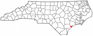
Onslow County is a county located in the U.S. state of North Carolina. As of the 2020 census, the population was 204,576. Its county seat is Jacksonville. The county was created in 1734 as Onslow Precinct and gained county status in 1739. Onslow County comprises the Jacksonville, NC Metropolitan Statistical Area. The southern border is the coast of the Atlantic Ocean.

<span class="mw-page-title-main">Towns County, Georgia</span> County in Georgia, United States

Towns County is a county located in the northeastern part of the U.S. state of Georgia. As of the 2020 census, the population was 12,493. Its county seat is Hiawassee. The county was created on March 6, 1856, and named for lawyer, legislator, and politician George W. Towns.

<span class="mw-page-title-main">Argos, Indiana</span> American town in Indiana

Argos is a town in Green and Walnut townships, Marshall County, Indiana, United States. The population was 1,777 at the 2020 census.

<span class="mw-page-title-main">Mount Desert, Maine</span> Town in the state of Maine, United States

Mount Desert is a town on Mount Desert Island in Hancock County, Maine, United States. The population was 2,146 at the 2020 census. Incorporated in 1789, the town currently encompasses the villages of Otter Creek, Seal Harbor, Northeast Harbor, Somesville, Hall Quarry, and Pretty Marsh.

<span class="mw-page-title-main">Graham, North Carolina</span> City in North Carolina, United States

Graham is a city in Alamance County, North Carolina, United States. It is part of the Burlington, North Carolina Metropolitan Statistical Area. As of the 2020 census the population was 17,153. It is the county seat of Alamance County.

<span class="mw-page-title-main">Jackson, North Carolina</span> Town in North Carolina, United States

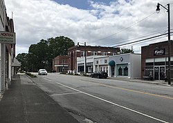
Jackson is a town in Northampton County, North Carolina, United States. The population was 513 at the 2010 census. It is the county seat of Northampton County.

<span class="mw-page-title-main">Holly Ridge, North Carolina</span> Town in North Carolina, United States

Holly Ridge is a town in Onslow County, North Carolina, United States. The 2010 population was 1,268. The 2020 census population was 4,171. It is part of the Jacksonville, North Carolina Metropolitan Statistical Area. It is considered the gateway to Topsail Island.

<span class="mw-page-title-main">Jacksonville, North Carolina</span> City in North Carolina, United States

Jacksonville is a city in Onslow County, North Carolina, United States. As of the 2020 census, the population was 72,723, which makes Jacksonville the 14th-most populous city in North Carolina. Jacksonville is the county seat and most populous community of Onslow County, which is coterminous with the Jacksonville, NC Metropolitan Statistical Area. Demographically, Jacksonville is the youngest city in the United States, with an average age of 22.8 years old, which can be attributed to the large military presence. The low age may also be in part due to the population drastically increasing over the past 80 years, from 783 in the 1930 census to 72,723 in the 2020 census.

<span class="mw-page-title-main">Sneads Ferry, North Carolina</span> CDP in North Carolina, United States

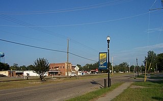
Sneads Ferry is a census-designated place (CDP) in Onslow County, North Carolina, United States. It is the second largest municipality in Onslow County, behind Jacksonville and is part of the Jacksonville, North Carolina Metropolitan Statistical Area. Once a rural fishing village, Sneads Ferry has experienced a surge in development since 2000. Based on U.S. Census data, the study area has grown from 5,425 residents in 2000 to approximately 9,750 residents in 2014, an 80% increase. Growth primarily has been driven by accessibility to MCB Camp Lejeune from the gate on NC 172 and expansion of the United States Marine Corps Special Operations Command (MARSOC) accessed from NC 210. Sneads Ferry is expected to continue growing rapidly at 3.3% annually, adding 17,500 new residents through 2040 reaching 20,000 in total population by 2030.

<span class="mw-page-title-main">Swansboro, North Carolina</span> Town in North Carolina, United States

Swansboro is a town in Onslow County, North Carolina, United States, located along the Crystal Coast. In 2020, the population was 3,744.

<span class="mw-page-title-main">Lucas, Ohio</span> Village in Ohio, United States

Lucas is a village in southeastern Richland County, Ohio, United States. Lucas is part of the Mansfield, Ohio Metropolitan Statistical Area. The population was 589 at the 2020 census.

<span class="mw-page-title-main">Pamplico, South Carolina</span> Town in South Carolina, United States

Pamplico is a town in southeastern Florence County, South Carolina, United States. The population was 1,226 at the 2010 census. It is part of the Florence Metropolitan Statistical Area.

<span class="mw-page-title-main">Gilbert, South Carolina</span> Town in South Carolina, United States

Gilbert is a town in Lexington County, South Carolina, United States. The population was 569 at the 2010 census. It is part of the Columbia, South Carolina Metropolitan Statistical Area.

<span class="mw-page-title-main">Eastover, South Carolina</span> Town in South Carolina, United States

Eastover is a town in Richland County, South Carolina, United States. The population was 813 at the 2010 census, down from 830 in 2000. It is part of the Columbia, South Carolina, Metropolitan Statistical Area.

<span class="mw-page-title-main">St. Andrews, South Carolina</span> Census-designated place in South Carolina, United States

St. Andrews is a census-designated place (CDP) in Richland County, South Carolina, United States. The population was 20,493 at the 2010 census. It is part of the Columbia, South Carolina Metropolitan Statistical Area.

<span class="mw-page-title-main">Richlands, Virginia</span> Town in Virginia, United States

Richlands is a town in Tazewell County, Virginia, United States. The population was 5,261 at the 2020 census. It is part of the Bluefield, WV-VA micropolitan area which has a population of 107,578.

<span class="mw-page-title-main">Blythewood, South Carolina</span> Town in South Carolina, United States

Blythewood is a town in Richland and Fairfield counties, South Carolina, United States. It is a suburb of Columbia, South Carolina. The 2020 United States census puts the population at 4,772. It is part of the Columbia, South Carolina, Metropolitan Statistical Area. It is located around 15 miles from downtown Columbia.

<span class="mw-page-title-main">Irmo, South Carolina</span> Town in South Carolina, United States

Irmo is a town in Lexington and Richland counties, South Carolina, United States and a suburb of Columbia. It is part of the Columbia Metropolitan Statistical Area and is located 12 miles (19 km) northwest of the city center. The population of Irmo was 11,097 at the 2010 census.

References

  1. "ArcGIS REST Services Directory". United States Census Bureau. Retrieved September 20, 2022.
  2. 1 2 U.S. Geological Survey Geographic Names Information System: Richlands, North Carolina
  3. 1 2 "U.S. Census website". United States Census Bureau . Retrieved January 31, 2008.
  4. Richlands, North Carolina
  5. Onslow County Museum
  6. Town of Richlands
  7. "Onslow County". Jim Forte Postal History. Retrieved November 1, 2015.
  8. Proffitt, Martie (April 17, 1983). "Local history offers tasty tidbits". Star-News. pp. 8C. Retrieved November 1, 2015.
  9. "National Register Information System". National Register of Historic Places . National Park Service. July 9, 2010.
  10. "Census of Population and Housing". Census.gov. Retrieved June 4, 2015.
  11. "Explore Census Data". data.census.gov. Retrieved December 24, 2021.
  12. Farmer's Day Promotional Information