Pumpkin Center, North Carolina

Last updated

Pumpkin Center, North Carolina
CDP
NCMap-doton-PumpkinCenter.PNG
Location of Pumpkin Center, North Carolina
Coordinates: 34°47′10″N77°21′51″W / 34.78611°N 77.36417°W / 34.78611; -77.36417
Country United States
State North Carolina
County Onslow
Area
[1]
  Total1.27 sq mi (3.28 km2)
  Land1.27 sq mi (3.28 km2)
  Water0.00 sq mi (0.00 km2)
Elevation
[2]
36 ft (11 m)
Population
 (2020)
  Total1,855
  Density1,464.09/sq mi (565.36/km2)
Time zone UTC-5 (Eastern (EST))
  Summer (DST) UTC-4 (EDT)
ZIP code
28546 [3]
Area codes 910, 472
FIPS code 37-54160 [4]
GNIS feature ID2403454 [2]

Pumpkin Center is a census-designated place (CDP) in Onslow County, North Carolina, United States. The population was 2,228 at the 2000 census. It is part of the Jacksonville, North Carolina Metropolitan Statistical Area.

Contents

Geography

According to the United States Census Bureau, the CDP has a total area of 1.4 square miles (3.5 km2), all land.

Demographics

Historical population
CensusPop.Note
2020 1,855
U.S. Decennial Census [5]

As of the census [4] of 2000, there were 2,228 people, 734 households, and 609 families residing in the CDP. The population density was 1,641.0 inhabitants per square mile (633.6/km2). There were 769 housing units at an average density of 566.4 per square mile (218.7/km2). The racial makeup of the CDP was 68.94% White, 19.08% African American, 0.49% Native American, 3.32% Asian, 1.26% Pacific Islander, 2.78% from other races, and 4.13% from two or more races. Hispanic or Latino of any race were 6.46% of the population.

There were 734 households, out of which 41.8% had children under the age of 18 living with them, 68.1% were married couples living together, 11.2% had a female householder with no husband present, and 16.9% were non-families. 13.4% of all households were made up of individuals, and 4.6% had someone living alone who was 65 years of age or older. The average household size was 3.04 and the average family size was 3.30.

In the CDP, the population was spread out, with 30.7% under the age of 18, 9.4% from 18 to 24, 28.8% from 25 to 44, 23.5% from 45 to 64, and 7.6% who were 65 years of age or older. The median age was 33 years. For every 100 females, there were 97.0 males. For every 100 females age 18 and over, there were 92.8 males.

The median income for a household in the CDP was $42,730, and the median income for a family was $42,443. Males had a median income of $30,911 versus $21,122 for females. The per capita income for the CDP was $16,144. About 3.0% of families and 3.9% of the population were below the poverty line, including 4.9% of those under age 18 and none of those age 65 or over.

Related Research Articles

<span class="mw-page-title-main">Underwood-Petersville, Alabama</span> Census-designated place in Alabama, United States

Underwood-Petersville is a census-designated place (CDP) in Lauderdale County, Alabama United States. It is part of the Florence - Muscle Shoals Metropolitan Statistical Area known as "The Shoals". As of the 2010 census, the population of the CDP is 3,247.

<span class="mw-page-title-main">Zephyrhills South, Florida</span> CDP in Florida, United States

Zephyrhills South is a census-designated place (CDP) in Pasco County, Florida, United States. The population was 4,435 at the 2000 census.

<span class="mw-page-title-main">Mehlville, Missouri</span> CDP in Missouri, United States

Mehlville is a census-designated place (CDP) in south St. Louis County, Missouri, United States, an area locally known as "South County". It is an inner-ring suburb of St. Louis, and part of the Greater St. Louis metropolitan area.

<span class="mw-page-title-main">Brinckerhoff, New York</span> Census-designated place in New York, United States

Brinckerhoff is a hamlet and census-designated place (CDP) in Dutchess County, New York, United States. The population was 2,900 at the 2010 census. It is part of the Poughkeepsie–Newburgh–Middletown, NY Metropolitan Statistical Area as well as the larger New York–Newark–Bridgeport, NY-NJ-CT-PA Combined Statistical Area.

<span class="mw-page-title-main">Altamahaw, North Carolina</span> Census-designated place in North Carolina, United States

Altamahaw is a census-designated place (CDP) in Alamance County, North Carolina, United States. It is part of the Burlington, North Carolina Metropolitan Statistical Area. As of the 2010 census it had a population of 347. The community was listed as Altamahaw-Ossipee at the 2000 census, at which time the population was 996. The town of Ossipee incorporated in 2002 and currently has a population of 543. The remainder of the territory was reassigned as the Altamahaw CDP.

<span class="mw-page-title-main">Woodlawn, North Carolina</span> Census-designated place in North Carolina, United States

Woodlawn is a census-designated place in Alamance County, North Carolina, United States.

<span class="mw-page-title-main">Icard, North Carolina</span> Census-designated place in North Carolina, United States

Icard is a census-designated place (CDP) in Burke County, North Carolina, United States. The population was 2,664 at the 2010 census. It is part of the Hickory–Lenoir–Morganton Metropolitan Statistical Area.

<span class="mw-page-title-main">Fairplains, North Carolina</span> CDP in North Carolina, United States

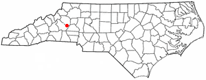
Fairplains is a census-designated place (CDP) in Wilkes County, North Carolina, United States. The population was 2,051 at the 2000 census. The community was named "fairplains" because it was located at the geographic point where the foothills of the Blue Ridge Mountains begin to level off to the gently rolling Piedmont region of central North Carolina.

<span class="mw-page-title-main">West Hills, Pennsylvania</span> Census-designated place in Pennsylvania, United States

West Hills is a census-designated place (CDP) in Armstrong County, Pennsylvania, United States. The population was 1,228 at the 2020 census.

<span class="mw-page-title-main">Sanatoga, Pennsylvania</span> Census-designated place in Pennsylvania, United States

Sanatoga is a community and census-designated place (CDP) that is located in Lower Pottsgrove Township, Montgomery County, Pennsylvania, United States. It is situated immediately east of the borough of Pottstown on U.S. Route 422.

<span class="mw-page-title-main">Sheppton, Pennsylvania</span> CDP in Pennsylvania, United States

Sheppton is a census-designated place (CDP) in Schuylkill County, Pennsylvania, United States. The population was 239 at the 2000 census.

<span class="mw-page-title-main">Thompsonville, Pennsylvania</span> Census-designated place in Pennsylvania, United States

Thompsonville is a census-designated place (CDP) in Washington County, Pennsylvania, United States. The population was 3,520 at the 2010 census.

<span class="mw-page-title-main">Spry, Pennsylvania</span> CDP in Pennsylvania, United States

Spry is a census-designated place (CDP) that is located in York County, Pennsylvania, United States. The population was 4,891 at the time of the 2010 census.

<span class="mw-page-title-main">Susquehanna Trails, Pennsylvania</span> CDP in Pennsylvania, United States

Susquehanna Trails is a census-designated place (CDP) in York County, Pennsylvania, United States. The population was 2,264 at the 2010 census.

<span class="mw-page-title-main">Burnettown, South Carolina</span> Town in South Carolina, United States of America

Burnettown is a town in Aiken County, South Carolina, United States. The population was 3,105 at the 2020 census. It is part of the Augusta, Georgia metropolitan area. Burnettown is located in historic Horse Creek Valley.

<span class="mw-page-title-main">Dentsville, South Carolina</span> Census-designated place in South Carolina, United States

Dentsville is a census-designated place (CDP) in Richland County, South Carolina, United States. The population was 14,062 at the 2010 census. It is part of the Columbia, South Carolina, Metropolitan Statistical Area.

<span class="mw-page-title-main">Mayo, South Carolina</span> CDP in South Carolina, United States

Mayo is a census-designated place (CDP) in Spartanburg County, South Carolina, United States. The population was 1,592 at the 2010 census.

<span class="mw-page-title-main">Cana, Virginia</span> CDP in Virginia, United States

Cana is a census-designated place (CDP) in Carroll County, Virginia, United States. The population was 1,254 at the 2010 census, up from 1,228 in 2000. It is the only CDP designated area in the county that is outside of the Appalachian Mountains in the Virginia Piedmont.

Rumford is a census-designated place (CDP) in the town of Rumford in Oxford County, Maine, United States. The population was 4,795 at the 2000 census.

East Millinocket is a census-designated place (CDP) consisting of the main settlement in the town of East Millinocket in Penobscot County, Maine, United States. The population was 1,567 at the 2010 census.

References

  1. "ArcGIS REST Services Directory". United States Census Bureau. Retrieved September 20, 2022.
  2. 1 2 U.S. Geological Survey Geographic Names Information System: Pumpkin Center, North Carolina
  3. "Pumpkin Center ZIP Code". zipdatamaps.com. 2023. Retrieved January 12, 2023.
  4. 1 2 "U.S. Census website". United States Census Bureau . Retrieved January 31, 2008.
  5. "Census of Population and Housing". Census.gov. Retrieved June 4, 2016.