Holly Ridge, North Carolina

Last updated

Holly Ridge, North Carolina
NCMap-doton-HollyRidge.PNG
Location of Holly Ridge, North Carolina
Coordinates: 34°29′28″N77°33′19″W / 34.49111°N 77.55528°W / 34.49111; -77.55528
Country United States
State North Carolina
County Onslow
Area
[1]
  Total4.23 sq mi (10.96 km2)
  Land4.23 sq mi (10.95 km2)
  Water0.00 sq mi (0.01 km2)
Elevation
[2]
49 ft (15 m)
Population
 (2020)
  Total4,171
  Density986.75/sq mi (380.95/km2)
Time zone UTC-5 (Eastern (EST))
  Summer (DST) UTC-4 (EDT)
ZIP code
28445
Area codes 910, 472
FIPS code 37-32180 [3]
GNIS feature ID2405853 [2]
Website https://hollyridgenc.org/

Holly Ridge is a town in Onslow County, North Carolina, United States. The 2010 population was 1,268. [4] The 2020 census population was 4,171. It is part of the Jacksonville, North Carolina Metropolitan Statistical Area. It is considered the gateway to Topsail Island.

Contents

Population Boom: In 1940, the town had 28 residents. Just three years later in 1943, the town had ballooned to 1,000 residents due to the establishing of the Camp Davis Army post.

Industry: The town's largest employer is J&J Snack Foods. Industrial growth is strengthening with the growth of the Camp Davis Industrial Park which resides on the same land that Camp Davis had occupied. The industrial park's largest tenants are Gulfstream Steel and Onslow Bay Boatworks. Atlantic Seafood is planning a 63,000 square foot facility with construction slated to begin in 2021. Plans for developing an additional 60 acres (referred to Camp Davis Industrial Park Phase 2) is underway with hopes to have shovel ready lots available for purchase in 2023.

Geography

According to the United States Census Bureau, the town has a total area of 1.4 square miles (3.6 km2), all land.

Demographics

Historical population
CensusPop.Note
1950 1,082
1960 731−32.4%
1970 415−43.2%
1980 46512.0%
1990 72856.6%
2000 83114.1%
2010 1,26852.6%
2020 4,171228.9%
2023 (est.)5,17024.0%
U.S. Decennial Census [5]

2020 census

Holly Ridge racial composition [6]
RaceNumberPercentage
White (non-Hispanic)3,19276.53%
Black or African American (non-Hispanic)19014.56%
Native American 170.41%
Asian 691.65%
Pacific Islander 130.31%
Other/Mixed 3017.22%
Hispanic or Latino 3899.33%

As of the 2020 United States census, there were 4,171 people, 981 households, and 702 families residing in the town.

2000 census

As of the census [3] of 2000, there were 831 people, 321 households, and 226 families residing in the town. The population density was 604.9 inhabitants per square mile (233.6/km2). There were 498 housing units at an average density of 362.5 per square mile (140.0/km2). The racial makeup of the town was 79.78% White, 14.56% African American, 1.32% Native American, 0.60% Asian, 0.12% Pacific Islander, 2.53% from other races, and 1.08% from two or more races. Hispanic or Latino of any race were 3.85% of the population.

There were 321 households, out of which 37.4% had children under the age of 18 living with them, 42.4% were married couples living together, 22.7% had a female householder with no husband present, and 29.3% were non-families. 19.6% of all households were made up of individuals, and 9.0% had someone living alone who was 65 years of age or older. The average household size was 2.49 and the average family size was 2.87.

In the town, the population was spread out, with 27.6% under the age of 18, 10.1% from 18 to 24, 27.4% from 25 to 44, 20.6% from 45 to 64, and 14.3% who were 65 years of age or older. The median age was 33 years. For every 100 females, there were 86.3 males. For every 100 females age 18 and over, there were 78.1 males.

The median income for a household in the town was $25,573, and the median income for a family was $26,979. Males had a median income of $27,059 versus $21,000 for females. The per capita income for the town was $12,585. About 19.0% of families and 24.1% of the population were below the poverty line, including 35.1% of those under age 18 and 14.3% of those age 65 or over.

Education

Related Research Articles

<span class="mw-page-title-main">Pender County, North Carolina</span> County in North Carolina, United States

Pender County is a county located in the U.S. state of North Carolina. As of the 2020 census, the population was 60,203. Its county seat is Burgaw. Pender County is part of the Wilmington, NC Metropolitan Statistical Area.

<span class="mw-page-title-main">Onslow County, North Carolina</span> County in North Carolina, United States

Onslow County is a county located in the U.S. state of North Carolina. As of the 2020 census, the population was 204,576. Its county seat is Jacksonville. The county was created in 1734 as Onslow Precinct and gained county status in 1739. Onslow County comprises the Jacksonville, NC Metropolitan Statistical Area. The southern border is the coast of the Atlantic Ocean.

<span class="mw-page-title-main">Jones County, North Carolina</span> County in North Carolina, United States

Jones County is a county located in the U.S. state of North Carolina. As of the 2020 census, the population was 9,172, making it the fourth-least populous county in North Carolina. Its county seat is Trenton. Jones County is part of the New Bern, NC Micropolitan Statistical Area.

<span class="mw-page-title-main">Tiger, Georgia</span> Town in Georgia, United States

Tiger is a town in Rabun County, Georgia, United States. The population was 574 at the 2020 census, up from 408 at the 2010 census.

<span class="mw-page-title-main">Cedar Point, North Carolina</span> Town in North Carolina, United States

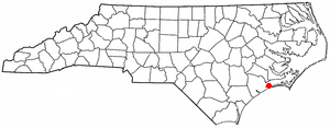
Cedar Point is a town in Carteret County, North Carolina, United States. The population was 1,297 in 2010.

<span class="mw-page-title-main">Peletier, North Carolina</span> Town in North Carolina, United States

Peletier is a town in Carteret County, North Carolina, United States. The population was 644 at the 2010 census.

<span class="mw-page-title-main">Kenansville, North Carolina</span> Town in North Carolina, United States

Kenansville is a town in Duplin County, North Carolina, United States. Its population was 770 at the 2020 census. It is the county seat of Duplin County. The town was named for James Kenan, a member of the North Carolina Senate. Liberty Hall, his early 1800s era historic home, is located within Kenansville.

<span class="mw-page-title-main">Oak Ridge, North Carolina</span> Town in North Carolina, United States

Oak Ridge is a town in northwestern Guilford County, North Carolina, United States. As of the census of 2020, the town had a population of 7,474. Oak Ridge is 15 miles (24 km) northwest of the center of Greensboro, North Carolina's third-most populous city. Oak Ridge is a part of the Piedmont Triad urban area.

<span class="mw-page-title-main">Jacksonville, North Carolina</span> City in North Carolina, United States

Jacksonville is a city in Onslow County, North Carolina, United States. As of the 2020 census, the population was 72,723, which makes Jacksonville the 14th-most populous city in North Carolina. Jacksonville is the county seat and most populous community of Onslow County, which is coterminous with the Jacksonville, NC Metropolitan Statistical Area. Demographically, Jacksonville is the youngest city in the United States, with an average age of 22.8 years old, which can be attributed to the large military presence. The low age may also be in part due to the population drastically increasing over the past 80 years, from 783 in the 1930 census to 72,723 in the 2020 census.

<span class="mw-page-title-main">North Topsail Beach, North Carolina</span> Town in North Carolina, United States

North Topsail Beach is a town in Onslow County, North Carolina, United States. As of the 2020 U.S. census, the population was 1,005. It is located on Topsail Island. North Topsail Beach is part of the Jacksonville, North Carolina Metropolitan Statistical Area.

<span class="mw-page-title-main">Richlands, North Carolina</span> Town in North Carolina, United States

Richlands is a town in Onslow County, North Carolina, United States. In the 2020 U.S. census, the population was 2,287. It is included in the Jacksonville, North Carolina Metropolitan Statistical Area. Incorporated on March 29, 1880, it was the first town in Onslow County to have its own library and museum. Richlands was also the first town in Onslow County to have a female mayor, Annette Hargett.

<span class="mw-page-title-main">Sneads Ferry, North Carolina</span> CDP in North Carolina, United States

Sneads Ferry is a census-designated place (CDP) in Onslow County, North Carolina, United States. It is the second largest municipality in Onslow County, behind Jacksonville and is part of the Jacksonville, North Carolina Metropolitan Statistical Area. Once a rural fishing village, Sneads Ferry has experienced a surge in development since 2000. Based on U.S. Census data, the study area has grown from 5,425 residents in 2000 to approximately 9,750 residents in 2014, an 80% increase. Growth primarily has been driven by accessibility to MCB Camp Lejeune from the gate on NC 172 and expansion of the United States Marine Corps Special Operations Command (MARSOC) accessed from NC 210. Sneads Ferry is expected to continue growing rapidly at 3.3% annually, adding 17,500 new residents through 2040 reaching 20,000 in total population by 2030.

<span class="mw-page-title-main">Swansboro, North Carolina</span> Town in North Carolina, United States

Swansboro is a town in Onslow County, North Carolina, United States, located along the Crystal Coast. In 2020, the population was 3,744.

<span class="mw-page-title-main">Winterville, North Carolina</span> Town in North Carolina, United States

Winterville is a town in Pitt County, North Carolina, United States. The population was 10,591 as of the 2020 census. The town is a part of the Greenville Metropolitan Area.

<span class="mw-page-title-main">Randleman, North Carolina</span> City in North Carolina, United States

Randleman is a city in Randolph County, North Carolina, United States. The population was 4,113 at the 2010 census. It is the home of NASCAR's Petty family, the Victory Junction Gang Camp and was the location of the Richard Petty Museum from 2003 to 2014.

<span class="mw-page-title-main">Rosman, North Carolina</span> Town in North Carolina, United States

Rosman is a town in Transylvania County, North Carolina, United States. The population was 576 at the 2010 census. The northern terminus of U.S. Route 178 is less than one mile northwest of Rosman on U.S. Route 64.

<span class="mw-page-title-main">Johnston, South Carolina</span> Town in South Carolina, United States

Johnston is a town in Edgefield County, South Carolina, United States. The population was 2,362 at the 2010 census. It is part of the Augusta, Georgia, metropolitan area. The town's official welcome sign states that it is "Peach Capital of the World".

<span class="mw-page-title-main">Gaston, South Carolina</span> Town in South Carolina, United States

Gaston is a town in Lexington County, South Carolina, United States. The population was 1,645 at the 2010 census. It is part of the Columbia, South Carolina Metropolitan Statistical Area.

<span class="mw-page-title-main">Holly Hill, South Carolina</span> Town in South Carolina, United States

Holly Hill is a town in Orangeburg County, South Carolina, United States. The population was 1,277 at the 2010 census. Prior to 1910 it was located in the northwest portion of Saint James Goose Creek Township.

<span class="mw-page-title-main">Surf City, North Carolina</span> Town in North Carolina, United States

Surf City is a town in Onslow and Pender counties in the U.S. state of North Carolina. The population was 3,867 at the 2020 census. It is located on Topsail Island.

References

  1. "ArcGIS REST Services Directory". United States Census Bureau. Retrieved September 20, 2022.
  2. 1 2 U.S. Geological Survey Geographic Names Information System: Holly Ridge, North Carolina
  3. 1 2 "U.S. Census website". United States Census Bureau . Retrieved January 31, 2008.
  4. Holly Ridge, North Carolina (NC) Detailed Profile - relocation, real estate, travel, jobs, hospitals, schools, crime, news, sex offenders
  5. "Census of Population and Housing". Census.gov. Retrieved June 4, 2015.
  6. "Explore Census Data". data.census.gov. Retrieved December 24, 2021.