Lee County, North Carolina

Last updated

Lee County
Lee County Courthouse - Sanford, NC 1.jpg
Lee County Flag.gif
Lee County seal.jpg
Motto: 
"Committed Today for a Better Tomorrow"
Map of North Carolina highlighting Lee County.svg
Location within the U.S. state of North Carolina
North Carolina in United States.svg
North Carolina's location within the U.S.
Coordinates: 35°29′N79°10′W / 35.48°N 79.17°W / 35.48; -79.17
CountryFlag of the United States.svg United States
StateFlag of North Carolina.svg  North Carolina
FoundedMarch 6, 1907
Named for Robert E. Lee
Seat Sanford
Largest communitySanford
Area
  Total259.20 sq mi (671.3 km2)
  Land255.06 sq mi (660.6 km2)
  Water4.14 sq mi (10.7 km2)  1.60%
Population
 (2020)
  Total63,285
  Estimate 
(2023)
67,059
  Density281.2/sq mi (108.6/km2)
Time zone UTC−5 (Eastern)
  Summer (DST) UTC−4 (EDT)
Congressional district 9th
Website www.leecountync.gov

Lee County is a county located in the U.S. state of North Carolina. As of the 2020 census, the population was 63,285. [1] The county seat is Sanford. [2]

Contents

Lee County comprises the Sanford, NC Micropolitan Statistical Area, which is a part of the Raleigh-Durham-Cary, NC Combined Statistical Area, which had an estimated population of 2,368,947 in 2023. [3] [4]

History

Lee County was established on March 6, 1907, from parts of Chatham and Moore counties, and named for General Robert E. Lee, who served as the General in Chief of the Armies of the Confederate States in 1865. [5]

Geography

Lee County, North Carolina
Interactive map of Lee County

According to the U.S. Census Bureau, the county has a total area of 259.20 square miles (671.3 km2), of which 255.06 square miles (660.6 km2) is land and 4.14 square miles (10.7 km2) (1.60%) is water. [6]

State and local protected areas

Major water bodies

Adjacent counties

Major highways

Major infrastructure

Demographics

Historical population
CensusPop.Note
1910 11,376
1920 13,40017.8%
1930 16,99626.8%
1940 18,74310.3%
1950 23,52225.5%
1960 26,56112.9%
1970 30,46714.7%
1980 36,71820.5%
1990 41,37412.7%
2000 49,04018.5%
2010 57,86618.0%
2020 63,2859.4%
2023 (est.)67,059 [1] 6.0%
U.S. Decennial Census [8]
1790–1960 [9] 1900–1990 [10]
1990–2000 [11] 2010 [12] 2020 [1]

2020 census

Lee County racial composition [13]
RaceNumberPercentage
White (non-Hispanic)36,05556.97%
Black or African American (non-Hispanic)10,70116.91%
Native American 2310.37%
Asian 6431.02%
Pacific Islander 430.07%
Other/Mixed 2,4903.93%
Hispanic or Latino 13,12220.73%

As of the 2020 census, there were 63,285 people, 21,894 households, and 15,223 families residing in the county.

2000 census

At the 2000 census, [14] there were 49,040 people, 18,466 households, and 13,369 families residing in the county. The population density was 191 people per square mile (74 people/km2). There were 19,909 housing units at an average density of 77 units per square mile (30 units/km2). The racial makeup of the county was 70.03% White, 20.46% Black or African American, 0.42% Native American, 0.67% Asian, 0.04% Pacific Islander, 7.33% from other races, and 1.06% from two or more races. 11.65% of the population were Hispanic or Latino of any race. By 2005 14.2% of the County population was Latino. 20.2% of the population was African-American. 64.2% of the population was non-Hispanic whites.

In 2000 there were 18,466 households, out of which 33.30% had children under the age of 18 living with them, 54.30% were married couples living together, 13.40% had a female householder with no husband present, and 27.60% were non-families. 23.50% of all households were made up of individuals, and 8.80% had someone living alone who was 65 years of age or older. The average household size was 2.61 and the average family size was 3.05. In the county, the population was spread out, with 25.70% under the age of 18, 9.00% from 18 to 24, 29.70% from 25 to 44, 22.70% from 45 to 64, and 12.90% who were 65 years of age or older. The median age was 36 years. For every 100 females there were 97.50 males. For every 100 females age 18 and over, there were 95.00 males. The median income for a household in the county was $38,900, and the median income for a family was $45,373. Males had a median income of $32,780 versus $23,660 for females. The per capita income for the county was $19,147. About 9.80% of families and 12.80% of the population were below the poverty line, including 16.50% of those under age 18 and 12.20% of those age 65 or over.

Government and politics

Lee is a typical "Solid South" county in terms of voting patterns. From its first election in 1908 it voted Democratic by large margins until 1968, except in the 1928 election when anti-Prohibition Catholic Al Smith held the county by single digits. In 1968, Lee's Democratic streak was broken when its electorate chose the American Independent candidate George Wallace. After 1972, Lee has voted Republican in every election except for Jimmy Carter's two elections in 1976 and 1980.

United States presidential election results for Lee County, North Carolina [15]
Year Republican Democratic Third party
No.%No.%No.%
2020 16,46956.77%12,14341.86%3961.37%
2016 13,71254.66%10,46941.74%9033.60%
2012 13,15854.28%10,80144.56%2801.16%
2008 12,77553.70%10,78445.33%2290.96%
2004 11,83460.55%7,65739.18%520.27%
2000 9,40657.77%6,78541.67%920.57%
1996 7,32150.04%6,29042.99%1,0196.97%
1992 6,65845.42%5,85239.92%2,14914.66%
1988 7,10462.47%4,23137.21%360.32%
1984 8,19867.47%3,92532.30%280.23%
1980 4,84745.84%5,42651.31%3012.85%
1976 3,69141.80%5,10457.80%360.41%
1972 5,83672.71%2,02425.22%1662.07%
1968 2,58629.32%2,52428.61%3,71142.07%
1964 2,75336.79%4,73063.21%00.00%
1960 2,56335.42%4,67364.58%00.00%
1956 1,94831.88%4,16368.12%00.00%
1952 2,10530.99%4,68869.01%00.00%
1948 87120.03%3,23474.38%2435.59%
1944 80818.98%3,44881.02%00.00%
1940 52712.52%3,68287.48%00.00%
1936 67015.25%3,72384.75%00.00%
1932 68118.15%3,05881.50%130.35%
1928 1,41645.23%1,71554.77%00.00%
1924 71027.80%1,83471.81%100.39%
1920 1,14332.94%2,32767.06%00.00%
1916 57335.22%1,05464.78%00.00%
1912 45132.85%86262.78%604.37%

Lee County is a member of the regional Triangle J Council of Governments. The county is governed by a seven-member board of County Commissioners, elected at large to serve four-year terms. Terms are staggered so that, every two years, three or four Commissioners are up for election. The Commissioners enact policies such as establishment of the property tax rate, regulation of land use and zoning outside municipal jurisdictions, and adoption of the annual budget. Commissioners usually meet on the first and third Mondays of each month.

Communities

Map of Lee County with municipal and township labels Map of Lee County North Carolina With Municipal and Township Labels.PNG
Map of Lee County with municipal and township labels

City

Town

Unincorporated communities

Townships

The county is divided into seven townships, which are both numbered and named:

  • 1 (Greenwood)
  • 2 (Jonesboro)
  • 3 (Cape Fear)
  • 4 (Deep River)
  • 5 (East Sanford)
  • 6 (West Sanford)
  • 7 (Pocket)

Trivia

See also

Related Research Articles

<span class="mw-page-title-main">Wilson County, North Carolina</span> County in North Carolina, United States

Wilson County is a county located in the U.S. state of North Carolina. As of the 2020 census, the population was 78,784. The county seat is Wilson. The county comprises the Wilson, NC Micropolitan Statistical Area, which is also included within the Rocky Mount-Wilson-Roanoke Rapids, NC Combined Statistical Area.

<span class="mw-page-title-main">Vance County, North Carolina</span> County in North Carolina, United States

Vance County is a county located in the U.S. state of North Carolina. As of the 2020 census, the population was 42,578. Its county seat is Henderson.

<span class="mw-page-title-main">Transylvania County, North Carolina</span> County in North Carolina, United States

Transylvania County is a county in the U.S. state of North Carolina. As of the 2020 census the population is 32,986. Its county seat is Brevard.

<span class="mw-page-title-main">Stanly County, North Carolina</span> County in North Carolina, United States

Stanly County is a county in the U.S. state of North Carolina. As of the 2020 census, the population was 62,504. Its county seat is Albemarle.

<span class="mw-page-title-main">Pender County, North Carolina</span> County in North Carolina, United States

Pender County is a county located in the U.S. state of North Carolina. As of the 2020 census, the population was 60,203. Its county seat is Burgaw. Pender County is part of the Wilmington, NC Metropolitan Statistical Area.

<span class="mw-page-title-main">Pamlico County, North Carolina</span> County in North Carolina, United States

PamlicoCounty is a county located in the U.S. state of North Carolina. As of the 2020 census, the population was 12,276. Its county seat is Bayboro.

<span class="mw-page-title-main">Northampton County, North Carolina</span> County in North Carolina, United States

Northampton County is a county located in the U.S. state of North Carolina. As of the 2020 census, the population was 17,471. Its county seat is Jackson.

<span class="mw-page-title-main">Pasquotank County, North Carolina</span> County in North Carolina, United States

Pasquotank County is a county located in the U.S. state of North Carolina. As of the 2020 census, the population was 40,568. Its county seat is Elizabeth City.

<span class="mw-page-title-main">Nash County, North Carolina</span> County in North Carolina, United States

Nash County is a county located in the U.S. state of North Carolina. As of the 2020 census, the population was 94,970. Its county seat is Nashville.

<span class="mw-page-title-main">Lenoir County, North Carolina</span> County in North Carolina, United States

Lenoir County is a county in the U.S. state of North Carolina. As of the 2020 census, its population was 55,122. Its county seat is Kinston, located on the Neuse River, across which the county has its territory.

<span class="mw-page-title-main">Franklin County, North Carolina</span> County in North Carolina, United States

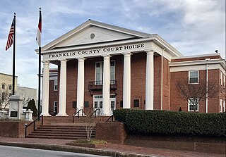
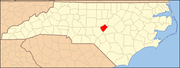
Franklin County is a county located in the U.S. state of North Carolina. As of the 2020 census, the population was 68,573. Its county seat is Louisburg.

<span class="mw-page-title-main">Forsyth County, North Carolina</span> County in North Carolina, United States

Forsyth County is located in the northwest Piedmont of the U.S. state of North Carolina. As of the 2020 census, the population was 382,590, making it the fourth-most populous county in North Carolina. Its county seat is Winston-Salem. Forsyth County is part of the Winston-Salem, NC, Metropolitan Statistical Area, which is also included in the Greensboro–Winston-Salem–High Point, NC, Combined Statistical Area. Portions of Forsyth County are in the Yadkin Valley wine region.

<span class="mw-page-title-main">Durham County, North Carolina</span> County in North Carolina, United States

Durham County is a county located in the U.S. state of North Carolina. As of the 2020 census, the population was 324,833, making it the sixth-most populous county in North Carolina. Its county seat is Durham, which is the only incorporated municipality predominantly in the county, though very small portions of cities and towns mostly in neighboring counties also extend into Durham County. The central and southern parts of Durham County are highly urban, consisting of the city as well as several unincorporated suburbs. Southeastern Durham County is dominated by the Research Triangle Park, most of which is in Durham County. The northern third of Durham County is rural in nature.

<span class="mw-page-title-main">Dare County, North Carolina</span> County in North Carolina, United States

Dare County is the easternmost county in the U.S. state of North Carolina. As of the 2020 census, the population was 36,915. Its county seat is Manteo.

<span class="mw-page-title-main">Cleveland County, North Carolina</span> County in North Carolina, United States

Cleveland County is a county located in the foothills of the Blue Ridge Mountains and the western Piedmont, on the southern border of the U.S. state of North Carolina. As of the 2020 census, the population was 99,519. Its county seat is Shelby. Cleveland County comprises the Shelby-Kings Mountain, NC Micropolitan Statistical Area, which is also included in the Charlotte-Concord, NC-SC Combined Statistical Area.

<span class="mw-page-title-main">Camden County, North Carolina</span> Consolidated city-county in North Carolina, United States

Camden County is a consolidated city-county located in the U.S. state of North Carolina. As of the 2020 census, the population was 10,355, making it the fourth-least populous county in North Carolina. Its county seat is Camden. Camden County is included in the Virginia Beach-Chesapeake, VA-NC Combined Statistical Area.

<span class="mw-page-title-main">Brunswick County, North Carolina</span> County in North Carolina, United States

Brunswick County is a county located in the U.S. state of North Carolina. It is the southernmost county in the state. As of the 2020 census, the population was 136,693. Its population was only 73,143 in 2000, making it one of the fastest-growing counties in the state. With a nominal growth rate of approximately 47% in ten years, much of the growth is centered in the eastern section of the county in the suburbs of Wilmington such as Leland, Belville and Southport. The county seat is Bolivia, which at a population of around 150 people is among the least populous county seats in the state.

<span class="mw-page-title-main">Beaufort County, North Carolina</span> County in North Carolina, United States

Beaufort County is a county located in the U.S. state of North Carolina. As of the 2020 census, the population was 44,652. Its county seat is Washington. The county was founded in 1705 as Pamptecough Precinct. Originally included in Bath County, it was renamed Beaufort Precinct in 1712 and became Beaufort County in 1739.

<span class="mw-page-title-main">Lillington, North Carolina</span> Town in North Carolina, United States

Lillington is a town and county seat of Harnett County, North Carolina, United States. Its population was 3,194 at the 2010 census, and was 4,735 in the 2020 census. Lillington is a part of the Dunn micropolitan area, which is also a part of the greater Raleigh–Durham–Cary combined statistical area as defined by the United States Census Bureau.

<span class="mw-page-title-main">Sanford, North Carolina</span> City in North Carolina, United States

Sanford is a city in Lee County, North Carolina, United States. The population was 30,261 at the 2020 census. It is the county seat of Lee County. The geographic center of North Carolina is located northwest of the city, in Chatham County.

References

  1. 1 2 3 "QuickFacts: Lee County, North Carolina". United States Census Bureau. Retrieved March 21, 2024.
  2. "Find a County". National Association of Counties. Retrieved June 7, 2011.
  3. "OMB Bulletin No. 23-01: Revised Delineations of Metropolitan Statistical Areas, Micropolitan Statistical Areas, and Combined Statistical Areas, and Guidance on Uses of the Delineations of These Areas" (PDF). United States Office of Management and Budget . July 21, 2023. Retrieved August 10, 2023.
  4. "Metropolitan and Micropolitan Statistical Areas Population Totals: 2020-2023". United States Census Bureau, Population Division. March 14, 2024. Retrieved March 15, 2024.
  5. "Establishment of Lee County". www.leecountync.gov. Retrieved March 16, 2018.
  6. "2020 County Gazetteer Files – North Carolina". United States Census Bureau. August 23, 2022. Retrieved September 9, 2023.
  7. "NCWRC Game Lands". www.ncpaws.org. Retrieved March 30, 2023.
  8. "U.S. Decennial Census". United States Census Bureau. Retrieved January 17, 2015.
  9. "Historical Census Browser". University of Virginia Library. Retrieved January 17, 2015.
  10. Forstall, Richard L., ed. (March 27, 1995). "Population of Counties by Decennial Census: 1900 to 1990". United States Census Bureau. Retrieved January 17, 2015.
  11. "Census 2000 PHC-T-4. Ranking Tables for Counties: 1990 and 2000" (PDF). United States Census Bureau. April 2, 2001. Archived (PDF) from the original on March 27, 2010. Retrieved January 17, 2015.
  12. "US Census Bureau Qi=uickFacts".
  13. "Explore Census Data". data.census.gov. Retrieved December 22, 2021.
  14. "U.S. Census website". United States Census Bureau . Retrieved January 31, 2008.
  15. Leip, David. "Dave Leip's Atlas of U.S. Presidential Elections". uselectionatlas.org. Retrieved March 16, 2018.
  16. The Longest Covered Bridge In North Carolina, At Ole Gilliam Mill Park, Is 140 Feet Long https://www.onlyinyourstate.com/north-carolina/ole-gilliam-mill-park-covered-bridge-sanford-nc/amp/