
North Carolina is a state in the Southeastern region of the United States. The state is the 28th largest and 9th-most populous of the 50 United States. It is bordered by Virginia to the north, the Atlantic Ocean to the east, Georgia and South Carolina to the south, and Tennessee to the west. Raleigh is the state's capital and Charlotte is its largest city. The Charlotte metropolitan area, with an estimated population of 2,754,842 in 2020, is the most-populous metropolitan area in North Carolina, the 23rd-most populous in the United States, and the largest banking center in the nation after New York City. The Raleigh-Durham-Cary combined statistical area is the second-largest metropolitan area in the state and 32nd-most populous in the United States, with an estimated population of 2,043,867 in 2020, and is home to the largest research park in the United States, Research Triangle Park.

South Carolina is a state in the coastal Southeastern region of the United States. It is bordered to the north by North Carolina, to the southeast by the Atlantic Ocean, and to the southwest by Georgia across the Savannah River. South Carolina is the 40th most extensive and 23rd most populous U.S. state with a recorded population of 5,124,712 according to the 2020 census. In 2019, its GDP was $213.45 billion. South Carolina is composed of 46 counties. The capital is Columbia with a population of 133,273 in 2019; while its largest city is Charleston with a 2020 population of 150,277. The Greenville–Spartanburg-Anderson metropolitan area is the most populous in the state, with a 2018 population estimate of 906,626.

Raleigh is the capital of the state of North Carolina and the seat of Wake County in the United States. It is the second-most populous city in North Carolina, tenth-most populous city in the Southeast, 41st-most populous city in the U.S., and the largest city of the Research Triangle metro area. Raleigh is known as the "City of Oaks" for its many oak trees, which line the streets in the heart of the city. The city covers a land area of 147.6 square miles (382 km2). The U.S. Census Bureau counted the city's population as 474,069 in 2020. It is one of the fastest-growing cities in the country. The city of Raleigh is named after Walter Raleigh, who established the lost Roanoke Colony in present-day Dare County.

The East Coast of the United States, also known as the Eastern Seaboard, the Atlantic Coast, and the Atlantic Seaboard, is the coastline along which the Eastern United States meets the North Atlantic Ocean. Regionally, the term refers to the coastal states and area east of the Appalachian Mountains that have shoreline on the Atlantic Ocean, from north to south, Maine, New Hampshire, Massachusetts, Rhode Island, Connecticut, New York, New Jersey, Delaware, Maryland, Virginia, North Carolina, South Carolina, Georgia, and Florida.
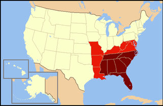
The southeastern United States, also referred to as the American Southeast or simply the Southeast, is broadly the eastern portion of the southern United States and the southern portion of the eastern United States. It comprises at least a core of states on the lower East Coast of the United States and eastern Gulf Coast. Expansively, it includes everything south of the Mason–Dixon line and Ohio River, stretching as far west as Arkansas and Louisiana, and as far north as West Virginia and Maryland. There is no official U.S. government definition of the region, though various agencies and departments use different definitions.
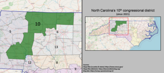
The 10th congressional district of North Carolina is a congressional district in central and western North Carolina. It currently includes all of Cleveland, Gaston, Lincoln, Polk, and Rutherford counties, and part of Catawba, Iredell, and Buncombe counties.

North Carolina's 2nd congressional district is located in the central part of the state. The district contains most of Wake County. Prior to court-mandated redistricting in 2019, it also included northern Johnston County, southern Nash County, far western Wilson County, and all of Franklin and Harnett counties. The 2nd district has been represented by Democratic Rep. Deborah Ross since 2021.

North Carolina's 11th congressional district encompasses most of Western North Carolina. Since January 3, 2021, the district has been represented by Madison Cawthorn.
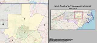
The 4th congressional district of North Carolina is located in the central region of the state. The district includes all of Durham County, Orange County, Granville County, and Franklin County, as well as portions of Chatham County, northern Wake County, and southern Vance County.

North Carolina's eighth congressional district is a United States congressional district that comprises a large portion of the southern Piedmont area of North Carolina from Concord to Spring Lake, including China Grove, Albemarle, Troy, Pinehurst and Raeford. The district includes all of Cabarrus County, Montgomery County, Moore County, Hoke County and Stanly County, as well as portions of Rowan County and Cumberland County.

North Carolina's 5th congressional district covers the central western portion of North Carolina from the Appalachian Mountains to the Metrolina western suburbs. the district borders Tennessee, Virginia and South Carolina While the bulk of its territory is in the mountains it stretches south into the Piedmont where its largest city, Gastonia, can be found. The district is overwhelmingly Republican. Large portions were controlled by Republicans even during the “Solid South” era as much of northwestern North Carolina was Quaker or mountaineer and therefore resisted secession. Two counties in the district – Avery and Yadkin – have never voted for a Democratic presidential candidate since their creation, and Wilkes County has never done so since before the Second Party System. For the 2020 election the district has been updated per House Bill 1029 enacted by the NC General Assembly on November 15, 2019, becoming Session Law 2019–249. District boundaries are based on 2010 census tabulation blocks.

North Carolina's 3rd congressional district is located on the Atlantic coast of North Carolina. It covers the Outer Banks and the counties adjacent to the Pamlico Sound.

North Carolina's 6th congressional district is located in north central portion of the state. As a result of court-mandated redistricting in 2019, it was shifted into the central Triad region and contains all of Guilford County and a portion of Forsyth County. The cities of Greensboro, Winston-Salem, and High Point are located in the district.

North Carolina's 7th congressional district stretches from Wilmington and the South Carolina border to the southern suburbs of Raleigh.
The following outline is provided as an overview of and topical guide to the U.S. state of North Carolina. Wikipedia:WikiProject North Carolina Category:Top-importance North Carolina articles are indicated.
The Gen. Joseph Arrington House is a historic plantation house located near Hilliardston, Nash County, North Carolina.

This is a list of elections in the U.S. state of North Carolina.


